
4.4: Earthquakes
- Page ID
- 12687

\( \newcommand{\vecs}[1]{\overset { \scriptstyle \rightharpoonup} {\mathbf{#1}} } \)
\( \newcommand{\vecd}[1]{\overset{-\!-\!\rightharpoonup}{\vphantom{a}\smash {#1}}} \)
\( \newcommand{\dsum}{\displaystyle\sum\limits} \)
\( \newcommand{\dint}{\displaystyle\int\limits} \)
\( \newcommand{\dlim}{\displaystyle\lim\limits} \)
\( \newcommand{\id}{\mathrm{id}}\) \( \newcommand{\Span}{\mathrm{span}}\)
( \newcommand{\kernel}{\mathrm{null}\,}\) \( \newcommand{\range}{\mathrm{range}\,}\)
\( \newcommand{\RealPart}{\mathrm{Re}}\) \( \newcommand{\ImaginaryPart}{\mathrm{Im}}\)
\( \newcommand{\Argument}{\mathrm{Arg}}\) \( \newcommand{\norm}[1]{\| #1 \|}\)
\( \newcommand{\inner}[2]{\langle #1, #2 \rangle}\)
\( \newcommand{\Span}{\mathrm{span}}\)
\( \newcommand{\id}{\mathrm{id}}\)
\( \newcommand{\Span}{\mathrm{span}}\)
\( \newcommand{\kernel}{\mathrm{null}\,}\)
\( \newcommand{\range}{\mathrm{range}\,}\)
\( \newcommand{\RealPart}{\mathrm{Re}}\)
\( \newcommand{\ImaginaryPart}{\mathrm{Im}}\)
\( \newcommand{\Argument}{\mathrm{Arg}}\)
\( \newcommand{\norm}[1]{\| #1 \|}\)
\( \newcommand{\inner}[2]{\langle #1, #2 \rangle}\)
\( \newcommand{\Span}{\mathrm{span}}\) \( \newcommand{\AA}{\unicode[.8,0]{x212B}}\)
\( \newcommand{\vectorA}[1]{\vec{#1}} % arrow\)
\( \newcommand{\vectorAt}[1]{\vec{\text{#1}}} % arrow\)
\( \newcommand{\vectorB}[1]{\overset { \scriptstyle \rightharpoonup} {\mathbf{#1}} } \)
\( \newcommand{\vectorC}[1]{\textbf{#1}} \)
\( \newcommand{\vectorD}[1]{\overrightarrow{#1}} \)
\( \newcommand{\vectorDt}[1]{\overrightarrow{\text{#1}}} \)
\( \newcommand{\vectE}[1]{\overset{-\!-\!\rightharpoonup}{\vphantom{a}\smash{\mathbf {#1}}}} \)
\( \newcommand{\vecs}[1]{\overset { \scriptstyle \rightharpoonup} {\mathbf{#1}} } \)
\(\newcommand{\longvect}{\overrightarrow}\)
\( \newcommand{\vecd}[1]{\overset{-\!-\!\rightharpoonup}{\vphantom{a}\smash {#1}}} \)
\(\newcommand{\avec}{\mathbf a}\) \(\newcommand{\bvec}{\mathbf b}\) \(\newcommand{\cvec}{\mathbf c}\) \(\newcommand{\dvec}{\mathbf d}\) \(\newcommand{\dtil}{\widetilde{\mathbf d}}\) \(\newcommand{\evec}{\mathbf e}\) \(\newcommand{\fvec}{\mathbf f}\) \(\newcommand{\nvec}{\mathbf n}\) \(\newcommand{\pvec}{\mathbf p}\) \(\newcommand{\qvec}{\mathbf q}\) \(\newcommand{\svec}{\mathbf s}\) \(\newcommand{\tvec}{\mathbf t}\) \(\newcommand{\uvec}{\mathbf u}\) \(\newcommand{\vvec}{\mathbf v}\) \(\newcommand{\wvec}{\mathbf w}\) \(\newcommand{\xvec}{\mathbf x}\) \(\newcommand{\yvec}{\mathbf y}\) \(\newcommand{\zvec}{\mathbf z}\) \(\newcommand{\rvec}{\mathbf r}\) \(\newcommand{\mvec}{\mathbf m}\) \(\newcommand{\zerovec}{\mathbf 0}\) \(\newcommand{\onevec}{\mathbf 1}\) \(\newcommand{\real}{\mathbb R}\) \(\newcommand{\twovec}[2]{\left[\begin{array}{r}#1 \\ #2 \end{array}\right]}\) \(\newcommand{\ctwovec}[2]{\left[\begin{array}{c}#1 \\ #2 \end{array}\right]}\) \(\newcommand{\threevec}[3]{\left[\begin{array}{r}#1 \\ #2 \\ #3 \end{array}\right]}\) \(\newcommand{\cthreevec}[3]{\left[\begin{array}{c}#1 \\ #2 \\ #3 \end{array}\right]}\) \(\newcommand{\fourvec}[4]{\left[\begin{array}{r}#1 \\ #2 \\ #3 \\ #4 \end{array}\right]}\) \(\newcommand{\cfourvec}[4]{\left[\begin{array}{c}#1 \\ #2 \\ #3 \\ #4 \end{array}\right]}\) \(\newcommand{\fivevec}[5]{\left[\begin{array}{r}#1 \\ #2 \\ #3 \\ #4 \\ #5 \\ \end{array}\right]}\) \(\newcommand{\cfivevec}[5]{\left[\begin{array}{c}#1 \\ #2 \\ #3 \\ #4 \\ #5 \\ \end{array}\right]}\) \(\newcommand{\mattwo}[4]{\left[\begin{array}{rr}#1 \amp #2 \\ #3 \amp #4 \\ \end{array}\right]}\) \(\newcommand{\laspan}[1]{\text{Span}\{#1\}}\) \(\newcommand{\bcal}{\cal B}\) \(\newcommand{\ccal}{\cal C}\) \(\newcommand{\scal}{\cal S}\) \(\newcommand{\wcal}{\cal W}\) \(\newcommand{\ecal}{\cal E}\) \(\newcommand{\coords}[2]{\left\{#1\right\}_{#2}}\) \(\newcommand{\gray}[1]{\color{gray}{#1}}\) \(\newcommand{\lgray}[1]{\color{lightgray}{#1}}\) \(\newcommand{\rank}{\operatorname{rank}}\) \(\newcommand{\row}{\text{Row}}\) \(\newcommand{\col}{\text{Col}}\) \(\renewcommand{\row}{\text{Row}}\) \(\newcommand{\nul}{\text{Nul}}\) \(\newcommand{\var}{\text{Var}}\) \(\newcommand{\corr}{\text{corr}}\) \(\newcommand{\len}[1]{\left|#1\right|}\) \(\newcommand{\bbar}{\overline{\bvec}}\) \(\newcommand{\bhat}{\widehat{\bvec}}\) \(\newcommand{\bperp}{\bvec^\perp}\) \(\newcommand{\xhat}{\widehat{\xvec}}\) \(\newcommand{\vhat}{\widehat{\vvec}}\) \(\newcommand{\uhat}{\widehat{\uvec}}\) \(\newcommand{\what}{\widehat{\wvec}}\) \(\newcommand{\Sighat}{\widehat{\Sigma}}\) \(\newcommand{\lt}{<}\) \(\newcommand{\gt}{>}\) \(\newcommand{\amp}{&}\) \(\definecolor{fillinmathshade}{gray}{0.9}\)|
LEARNING OUTCOMES
|
Causes and Types of Tectonic Stress

Enormous slabs of lithosphere move unevenly over the planet’s spherical surface, resulting in earthquakes. This chapter deals with two types of geological activity that occur because of plate tectonics: mountain building and earthquakes. First, we will consider what can happen to rocks when they are exposed to stress. Stress is the force applied to an object. In geosciences, stress is the force per unit area that is placed on a rock. Four types of stresses act on materials.
- A deeply buried rock is pushed down by the weight of all the material above it. Since the rock cannot move, it cannot deform called confining stress.
- Compression squeezes rocks together, causing rocks to fold or fracture. Compression is the most common stress at convergent plate boundaries.
- Rocks that are pulled apart are under tension. Rocks under tension lengthen or break apart. Tension is the major type of stress at divergent plate boundaries.
- When forces are parallel but moving in opposite directions, the stress is called shear. Shear stress is the most common stress at transform plate boundaries.
When stress causes a material to change shape, it has undergone strain or deformation. Deformed rocks are common in geologically active areas. A rock’s response to stress depends on the rock type, the surrounding temperature, and pressure conditions the rock is under, the length of time the rock is under stress, and the type of stress. The rocks then have three possible responses to increasing stress: elastic deformation, plastic deformation, or fracturing. Elastic deformation occurs when the rock returns to its original shape when the stress is removed. When rocks under stress do not return to its original shape when the stress is removed, it is called plastic deformation. Finally, when a rock under stress breaks, it’s called a fracture. Fractures can be either joints or faults.
Under what conditions do you think a rock is more likely to fracture? Is it more likely to break deep within Earth’s crust or at the surface? What if the stress applied is sharp rather than gradual? At the Earth’s surface, rocks usually break quite quickly, but deeper in the crust, where temperatures and pressures are higher, rocks are more likely to deform plastically. Sudden stress, such as a hit with a hammer, is more likely to make a rock break. Stress applied over time often leads to plastic def
Geologic Structures: Joints and Faults
FAULTS
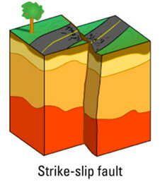
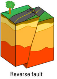
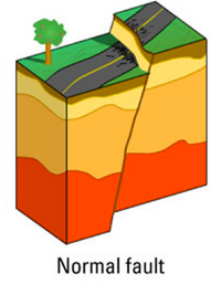
A rock under enough stress will eventually fracture. If there is no movement on either side of a fracture, the fracture is called a joint. But if the blocks of rock on one or both sides of a fracture move, the fracture is called a fault. Sudden motions along faults cause rocks to break and move suddenly, releasing the stored up stress energy to create an earthquake.A slip is the distance rocks move along a fault and can be up or down the fault plane. Slip is relative, because there is usually no way to know whether both sides moved or only one. Faults lie at an angle to the horizontal surface of the Earth. That angle is called the fault’s dip. The dip defines which of two basic types a fault is. If the fault’s dip is inclined relative to the horizontal, the fault is a dip-slip fault. There are two types of dip-slip faults. In normal faults, the hanging wall drops down relative to the footwall. Normal faults can be huge and are often times responsible for uplifting mountain ranges in regions experiencing tensional stress.With reverse faults, the footwall drops down relative to the hanging wall. A type of reverse fault is a thrust fault, in which the fault plane angle is nearly horizontal. Rocks can slip many miles along thrust faults.A strike-slip fault is a dip-slip fault in which the dip of the fault plane is vertical and result from shear stresses. California’s San Andreas Fault is the world’s most famous strike-slip fault. It is a right-lateral strike slip fault.
Causes of Earthquakes
An earthquake is sudden ground movement caused by the sudden release of energy stored in rocks, called the elastic rebound theory. Earthquakes happen when so much stress builds up in the rocks that the rocks rupture. The energy is transmitted by seismic waves. Each year there are more than 150,000 earthquakes strong enough to be felt by people and 900,000 recorded by seismometers!
In an earthquake, the initial point where the rocks rupture in the crust is called the focus (sometimes called the hypocenter). The epicenter is the point on the land surface that is directly above the focus. In about 75% of earthquakes, the focus is in the top 10 to 15 kilometers (6 to 9 miles) of the crust. Shallow earthquakes cause the most damage because the focus is near where people live. However, it is the epicenter of an earthquake that is reported by scientists and the media.
|
An interactive or media element has been excluded from this version of the text. You can view it online here: http://pb.libretexts.org/es/?p=58 |
An interactive or media element has been excluded from this version of the text. You can view it online here: http://pb.libretexts.org/es/?p=58 |
Earthquake Zones
Nearly 95% of all earthquakes take place along one of the three types of tectonic plate boundaries, but earthquakes do occur along all three types of plate boundaries. About 80% of all earthquakes strike around the Pacific Ocean basin because it is lined with convergent and transform boundaries. Called the Ring of Fire, this is also the location of most volcanoes around the planet. About 15% take place in the Mediterranean-Asiatic Belt, where convergence is causing the Indian Plate to run into the Eurasian Plate creating the largest mountain ranges in the world. The remaining 5% are scattered around other plate boundaries or are intraplate earthquakes.
TRANSFORM PLATE BOUNDARIES
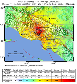
Recall that transform plate boundaries occur where two tectonic plates are grinding parallel to each other rather than colliding or subducting. Deadly earthquakes occur at transform plate boundaries, creating strike-slip faults, because they tend to have shallow focuses where the rupture occurs. The faults along the San Andreas Fault zone produce around 10,000 earthquakes a year. Most are tiny, but occasionally one is massive. In the San Francisco Bay Area, the Hayward Fault was the site of a magnitude 7.0 earthquake in 1868. The 1906 quake on the San Andreas Fault had a magnitude estimated at about 7.9.During the 1989 World Series, a magnitude 7.1 earthquake struck Loma Prieta, near Santa Cruz, California, killing 63 people, injuring 3,756, and cost $6 billion. A few years later in Northridge, California, a magnitude 6.7 earthquake killed 72 people, injured 12,000 people, and caused $12.5 billion in damage. This earthquake occurred on an unknown fault, because it was a blind thrust fault near Los Angeles, California.Although California is prone to many natural hazards, including volcanic eruptions at Mt. Shasta or Mt. Lassen, and landslides on coastal cliffs, the natural hazard the state is linked with is earthquakes. New Zealand also has strike-slip earthquakes, about 20,000 a year, but only a small percentage of those are large enough to be felt. A 6.3 quake in Christchurch in February 2011 killed about 180 people.
CONVERGENT PLATE BOUNDARIES
Earthquakes at convergent plate boundaries mark the motions of subducting lithosphere as it plunges through the mantle, creating reverse and thrust faults. Convergent plate boundaries produce earthquakes all around the Pacific Ocean basin. The Philippine Plate and the Pacific Plate subduct beneath Japan, creating a chain of volcanoes and produces as many as 1,500 earthquakes annually.In March 2011 an enormous 9.0 earthquake struck off of Sendai in northeastern Japan. This quake, called the 2011 Tōhoku earthquake, was the most powerful ever to strike Japan and one of the top five known in the world. Damage from the earthquake was nearly overshadowed by the tsunami it generated, which wiped out coastal cities and towns. Two months after the earthquake, about 25,000 people were dead or missing, and 125,000 buildings had been damaged or destroyed. Aftershocks, some as large as major earthquakes, have continued to rock the region. A map of aftershocks is seen here. Recently, the New York Times created an interactive website of the Japan earthquake and tsunami.The Pacific Northwest of the United States is at risk from a potentially massive earthquake that could strike any time. Subduction of the Juan de Fuca plate beneath North America produces active volcanoes, but large earthquakes only hit every 300 to 600 years. The last was in 1700, with an estimated magnitude of around 9.0. The elastic rebound theory as applied to subduction zones can be viewed here.
|
Massive earthquakes are the hallmark of the thrust faulting and folding when two continental plates converge. The 2001 Gujarat earthquake in India was responsible for about 20,000 deaths, and many more people became injured or homeless. In Understanding Earthquakes: From Research to Resilience, scientists try to understand the mechanisms that cause earthquakes and tsunamis and the ways that society can deal with them. |
An interactive or media element has been excluded from this version of the text. You can view it online here: http://pb.libretexts.org/es/?p=58 |
DIVERGENT PLATE BOUNDARIES
Earthquakes at mid-ocean ridges are small and shallow because the plates are young, thin, and hot. On land where continents split apart, earthquakes are larger and stronger. A classic example of normal faulting along divergent boundaries is the Wasatch Front in Utah and the entire Basin and Range through Nevada.
INTRAPLATE BOUNDARIES
Intraplate earthquakes are the result of stresses caused by plate motions acting in solid slabs of lithosphere. In 1812, a magnitude 7.5 earthquake struck near New Madrid, Missouri. The earthquake was strongly felt over approximately 50,000 square miles and altered the course of the Mississippi River. Because very few people lived there at the time, only 20 people died. Many more people live there today. A similar earthquake today would undoubtedly kill many people and cause a great deal of property damage.
Seismic Waves
Physics shows us that energy is always transmitted in waves. Every wave has a high point called a crest and a low point called a trough. The height of a wave from the center line to its crest is its amplitude. The distance between waves from crest to crest (or trough to trough) is its wavelength.
The energy from earthquakes travels in seismic waves, which were discussed in the chapter “Plate Tectonics.” The study of seismic waves is known as seismology. Seismologists use seismic waves to learn about earthquakes and also to learn about the Earth’s interior. The two types of seismic waves described in “Plate Tectonics,” P-waves and S-waves, are known as body waves because they move through the solid body of the Earth. P-waves travel through solids, liquids, and gases. S-waves only move through solids.Surface waves travel along the ground, outward from an earthquake’s epicenter. Surface waves are the slowest of all seismic waves, traveling at 2.5 km (1.5 miles) per second. In an earthquake, body waves produce sharp jolts, while rolling motions of surface waves do most of the damage in an earthquake.
MEASURING MAGNITUDE
Seismograms record seismic waves. Over the past century, scientists have developed several ways of measuring earthquake intensity. The currently accepted method is the moment magnitude scale, which measures the total amount of energy released by the earthquake. At this time, seismologists have not found a reliable method for predicting earthquakes.A seismograph produces a graph-like representation of the seismic waves it receives and records them onto a seismogram. Seismograms contain information that can be used to determine how strong an earthquake was, how long it lasted, and how far away it was. Modern seismometers record ground motions using electronic motion detectors. The data are then kept digitally on a computer.
If a seismogram records P-waves and surface waves but not S-waves, the seismograph was on the other side of the Earth from the earthquake because those waves cannot travel through the liquid core of the earth. The amplitude of the waves can be used to determine the magnitude of the earthquake, which will be discussed in a later section.
In order to locate an earthquake epicenter, scientists must first determine the epicenter distance from three different seismographs. The longer the time between the arrival of the P-wave and S-wave, the farther away is the epicenter. So the difference in the P and S wave arrival times determines the distance between the epicenter and a seismometer. This animation shows how distance is determined using P, S, and surface waves.
The scientist then draws a circle with a radius equal to the distance from the epicenter for that seismograph. The epicenter is somewhere along that circle. This is done for three locations. Using data from two seismographs, the two circles will intercept at two points. A third circle will intercept the other two circles at a single point. This point is the earthquake epicenter. Although useful for decades, this technique has been replaced by digital calculations. Seismic stations record ten earthquakes in this animation.
MEASURING EARTHQUAKES
People have always tried to quantify the size of and damage done by earthquakes. Since early in the 20th century, there have been three methods The oldest of the scales is called the Mercalli Intensity scale. Earthquakes are described in terms of what nearby residents felt and the damage that was done to nearby structures. This scale is more qualitative in information because it’s based on visual damage and not the actual energy released by the earthquake. Today these maps are still important and various seismological stations will create shake maps of the surface damage.With the invention of the seismograph station, the Richter magnitude scale was created. Developed in 1935 by Charles Richter, this scale uses a seismometer to measure the magnitude of the largest jolt of energy released by an earthquake. Today, the moment magnitude scale has replaced the Richter scale. The moment magnitude scale measures the total energy released by an earthquake. Moment magnitude is calculated from the area of the fault that is ruptured and the distance the ground moved along the fault.The Richter scale and the moment magnitude scale are logarithmic. The amplitude of the largest wave increases ten times from one integer to the next. An increase in one integer means that thirty times more energy was released. These two scales often give very similar measurements.How does the amplitude of the largest seismic wave of a magnitude 5 earthquake compare with the largest wave of a magnitude 4 earthquake? How does it compare with a magnitude 3 quake? The amplitude of the largest seismic wave of a magnitude 5 quake is 10 times that of a magnitude 4 quake and 100 times that of a magnitude 3 quake.Each scale has their benefits. As mentioned above, the Mercalli Intensity scale is based on how much damage someone would see. This is relative though because some places have strong building codes, and the rock material underneath will impact ground shaking without changing the energy released at the focus. With the Richter scale, a single sharp jolt measures higher than a very long intense earthquake that releases more energy. The moment magnitude scale more accurately reflects the energy released and the damage caused. Today, most seismologists now use the moment magnitude scale.
Annual Earthquakes
In a single year, on average, more than 900,000 earthquakes are recorded and 150,000 of them are strong enough to be felt. Each year about 18 earthquakes are major with a Richter magnitude of 7.0 to 7.9, and on average one earthquake has a magnitude of 8 to 8.9.
Magnitude 9 earthquakes are rare. The United States Geological Survey lists five since 1900 (see table below). All but the Great Indian Ocean Earthquake of 2004 occurred somewhere around the Pacific Ocean basin.
| Location Valdivia, Chile Prince Williams Sound, Alaska Great Indian Ocean Earthquake Kamchatka, Alaska Tohoku, Japan |
Year 1960 1964 2004 1952 2011 |
Magnitude 9.5 9.2 9.1 9.0 9.0 |
Earthquake Prediction
Scientists are a long way from being able to predict earthquakes. A good prediction must be accurate as to where an earthquake will occur, when it will occur, and at what magnitude it will be so that people can evacuate. An unnecessary evacuation is expensive and causes people not to believe authorities the next time an evacuation is ordered.
Where an earthquake will occur is the easiest feature to predict. Scientists know that earthquakes take place at plate boundaries and tend to happen where they’ve occurred before. Earthquake-prone communities should always be prepared for an earthquake. These communities can implement building codes to make structures earthquake safe.
When an earthquake will occur is much more difficult to predict. Since stress on a fault builds up at the same rate over time, earthquakes should occur at regular intervals. But so far scientists cannot predict when quakes will occur even to within a few years. Signs sometimes come before a large earthquake. Small quakes, called foreshocks, sometimes occur a few seconds to a few weeks before a major quake. However, many earthquakes do not have foreshocks and small earthquakes are not necessarily followed by a large earthquake. Often, the rocks around a fault will dilate as microfractures form.
Ground tilting, caused by the buildup of stress in the rocks, may precede a large earthquake, but not always. Water levels in wells fluctuate as water moves into or out of fractures before an earthquake. This is also an uncertain predictor of large earthquakes. The relative arrival times of P-waves and S-waves also decreases just before an earthquake occurs.
Folklore tells of animals behaving erratically just before an earthquake. Mostly these anecdotes are told after the earthquake. If indeed animals sense danger from earthquakes or tsunami, scientists do not know what it is they could be sensing, but they would like to find out.
The geology of California underlies the state’s wealth of natural resources as well as its natural hazards. This video explores the enormous diversity of California’s geology: http://www.youtube.com/watch?v=QzdBx9zL0ZY(57:50).
DAMAGE FROM EARTHQUAKES
Earthquakes are natural disasters that cause enormous amounts of damage, second only to hurricanes. Earthquake-safe construction techniques, securing heavy objects, and preparing an emergency kit are among the precautions people can take to minimize damage.Earthquakes kill people and cause property damage. However, the ground shaking almost never kills people, and the ground does not swallow someone up. The damage depends somewhat on the earthquake size but mostly on the quality of structures. Structures falling on people injure and kill them. More damage is done and more people are killed by the fires that follow an earthquake than the earthquake itself.
There are a variety of ways earthquakes become deadly. Probably the greatest influence is population density. The magnitude 9.2 Great Alaska Earthquake, near Anchorage, of 1964 resulted in only 131 deaths. At the time few people lived in the area. Oddly enough, size doesn’t matter. Only about 2,000 people died in the 1960 Great Chilean earthquake, the largest earthquake ever recorded. The Indian Ocean earthquake of 2004 was one of the largest ever, but most of the 230,000 fatalities were caused by the tsunami, not the earthquake itself.
Ground type is an important factor in earthquake damage. Solid bedrock vibrates less than soft sediments so there is less damage on bedrock. Sediments that are saturated with water under go liquefaction and become like quicksand. This will have dangerous implications for Salt Lake City and the Wasatch Front in Utah. Much of the Wasatch Front is loose soil, left over from the remnants of Lake Bonneville. Along the middle of the two mountain ranges, between the Wasatch Mountains and the Oquirrh Mountains, is the Jordan River which flows from Utah Lake northward to the Great Salt Lake. Near the river and surrounding floodplain, the water table is near the surface. When the ground shakes, the water near the surface shifts upward and over-saturates the soil making it extremely unstable. Earthquake effects on buildings are seen in this animation.
EARTHQUAKE-SAFE STRUCTURES
Construction is a large factor in what happens during an earthquake. For example, many more people died in the 1988 Armenia earthquake where people live in mud houses than in the 1989 earthquake in Loma Prieta. Most buildings in California’s earthquake country are designed to be earthquake safe.The key to earthquake safety are the structures we live in. It is often said that earthquakes don’t kill people, it’s the buildings that kill people. But the reason why not all buildings are not built to withstand earthquakes is cost. More sturdy structures are much more expensive to build, so communities must weigh how great the hazard is, what different building strategies cost, and make an informed decision. But this is the crucial factor in earthquake safety. Let’s compare Salt Lake City, UT and Port-au-Prince, Haiti. When Salt Lake City has it’s expected 7.0 magnitude earthquake, worst case scenario is that 3,000-4,000 will die. But on January 12, 2010, Haiti experienced a 7.0 magnitude earthquake that killed nearly 300,000 people. The difference – building codes.Skyscrapers and other large structures built on soft ground must be anchored to bedrock, even if it lies hundreds of meters below the ground surface. Larger buildings must sway, but not so much that they touch nearby buildings. Counterweights and diagonal steel beams are used to hold down sway. Large buildings can also be placed on rollers so that they move with the ground.Earthquake prone areas should have building codes that require the use of correct building materials. Houses should also be built with wood and steel rather than brick and stone because they need to be able to bend and sway. New buildings should be built on layers of steel and rubber to absorb the shock of the waves. Connections, such as where the walls meet the foundation, must be made strong to withstand the shaking. In a multi-story building, the first story must be well supported.To make older buildings more earthquake safe, retrofitting with steel or wood can reinforce a building’s structure and its connections. Elevated freeways and bridges can also be retrofitted so that they do not collapse.
Fires often cause more damage than the earthquake. Fires start because seismic waves rupture gas and electrical lines, and breaks in water mains make it difficult to fight the fires. Builders zigzag pipes so that they bend and flex when the ground shakes. In San Francisco, water and gas pipelines are separated by valves so that areas can be isolated if one segment breaks.
HUMAN-INDUCED EARTHQUAKES
Can humans create earthquakes? Maybe not intentionally, but the answer is yes and here is why. If a water reservoir is built on top of an active fault line, the water may actually lubricate the fault and weaken the stress built up within it. This may either create a series of small earthquakes or potentially create a large earthquake. Also the shear weight of the reservoir’s water can weaken the bedrock causing it to fracture. Then the obvious concern is if the dam fails. Earthquakes can also be generated if humans inject other fluids into a fault such as sewage or chemical waste. Finally, nuclear explosions can trigger earthquakes. In fact, one way to determine if a nation has tested a nuclear bomb is by monitoring the earthquakes and energy released by the explosion.
An interactive or media element has been excluded from this version of the text. You can view it online here: http://pb.libretexts.org/es/?p=58
- Provided by: Open Geography. Located at: http://www.opengeography.org/ch-5-tectonic-forces.html. License: CC BY: Attribution