

13.4: Landforms formed by glacial deposition
- Page ID
- 42720

\( \newcommand{\vecs}[1]{\overset { \scriptstyle \rightharpoonup} {\mathbf{#1}} } \)
\( \newcommand{\vecd}[1]{\overset{-\!-\!\rightharpoonup}{\vphantom{a}\smash {#1}}} \)
\( \newcommand{\dsum}{\displaystyle\sum\limits} \)
\( \newcommand{\dint}{\displaystyle\int\limits} \)
\( \newcommand{\dlim}{\displaystyle\lim\limits} \)
\( \newcommand{\id}{\mathrm{id}}\) \( \newcommand{\Span}{\mathrm{span}}\)
( \newcommand{\kernel}{\mathrm{null}\,}\) \( \newcommand{\range}{\mathrm{range}\,}\)
\( \newcommand{\RealPart}{\mathrm{Re}}\) \( \newcommand{\ImaginaryPart}{\mathrm{Im}}\)
\( \newcommand{\Argument}{\mathrm{Arg}}\) \( \newcommand{\norm}[1]{\| #1 \|}\)
\( \newcommand{\inner}[2]{\langle #1, #2 \rangle}\)
\( \newcommand{\Span}{\mathrm{span}}\)
\( \newcommand{\id}{\mathrm{id}}\)
\( \newcommand{\Span}{\mathrm{span}}\)
\( \newcommand{\kernel}{\mathrm{null}\,}\)
\( \newcommand{\range}{\mathrm{range}\,}\)
\( \newcommand{\RealPart}{\mathrm{Re}}\)
\( \newcommand{\ImaginaryPart}{\mathrm{Im}}\)
\( \newcommand{\Argument}{\mathrm{Arg}}\)
\( \newcommand{\norm}[1]{\| #1 \|}\)
\( \newcommand{\inner}[2]{\langle #1, #2 \rangle}\)
\( \newcommand{\Span}{\mathrm{span}}\) \( \newcommand{\AA}{\unicode[.8,0]{x212B}}\)
\( \newcommand{\vectorA}[1]{\vec{#1}} % arrow\)
\( \newcommand{\vectorAt}[1]{\vec{\text{#1}}} % arrow\)
\( \newcommand{\vectorB}[1]{\overset { \scriptstyle \rightharpoonup} {\mathbf{#1}} } \)
\( \newcommand{\vectorC}[1]{\textbf{#1}} \)
\( \newcommand{\vectorD}[1]{\overrightarrow{#1}} \)
\( \newcommand{\vectorDt}[1]{\overrightarrow{\text{#1}}} \)
\( \newcommand{\vectE}[1]{\overset{-\!-\!\rightharpoonup}{\vphantom{a}\smash{\mathbf {#1}}}} \)
\( \newcommand{\vecs}[1]{\overset { \scriptstyle \rightharpoonup} {\mathbf{#1}} } \)
\(\newcommand{\longvect}{\overrightarrow}\)
\( \newcommand{\vecd}[1]{\overset{-\!-\!\rightharpoonup}{\vphantom{a}\smash {#1}}} \)
\(\newcommand{\ket}[1]{\left| #1 \right>}\)
\(\newcommand{\bra}[1]{\left< #1 \right|}\)
\(\newcommand{\braket}[2]{\left< #1 \vphantom{#2} \right| \left. #2 \vphantom{#1} \right>}\)
\(\newcommand{\braopket}[3]{\left< #1 \vphantom{#2}\vphantom{#3} \right| #2 \vphantom{#1}\vphantom{#3} \left| #3 \vphantom{#1}\vphantom{#2} \right>}\)
\(\newcommand{\qmvec}[1]{\mathbf{\vec{#1}}}\)
\(\newcommand{\op}[1]{\hat{\mathbf{#1}}}\)
\(\newcommand{\expect}[1]{\langle #1 \rangle}\)
\(\newcommand{\dfn}[1]{\emph{\textbf{#1}}}\)
Depositional Processes of Glaciers
A receding continental glacier exposes a variety of depositional landforms, like drumlins, eskers, kettle lakes and moraines shown in Figure \(\PageIndex{1}\). Refer to this diagram as you read about the various depositional landforms created by glaciers.
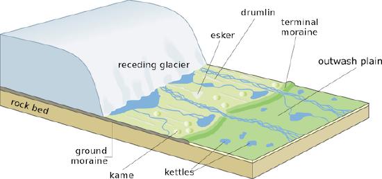
Figure \(\PageIndex{1}\) shows a receding glacier and several landforms created by glacial deposition. The glacier occupies the left side of the image and rests on a rock bed. In front of the glacier are deposits and features formed by melting ice and flowing water. Labeled landforms include a ground moraine beneath the glacier, a terminal moraine marking the glacier's former extent, an outwash plain formed by meltwater sediments, an esker created by sediment deposited by streams flowing within or beneath the ice, a drumlin shaped by moving ice, a kame formed by sediment accumulation, and kettles created when buried ice blocks melt and leave depressions. The diagram illustrates how retreating glaciers reshape landscapes through erosion, deposition, and meltwater processes.
Drumlin
These are oval, elongated hummocks made of boulder clay that resemble a whale's back. As illustrated in Figure \(\PageIndex{2}\), the downstream side is elongated in the direction of ice flow. Drumlins are low hills that are steeper on the windward side and taper off in the leeward side. Since they are commonly arranged diagonally and are often referred to as "basket of eggs" topography. The Ontario Drumlin field in Upper New York State is an example of this landform.

Figure \(\PageIndex{2}\) is a three-dimensional block model showing a retreating continental glacier and the depositional landforms left behind as the ice melts.
On the left side, a large mass of ice labeled receding glacier sits on a rock bed. The glacier is retreating away from the landscape in front of it, exposing sediment and depositional features created by glacial activity.
Several glacial landforms are labeled:
- Ground moraine – a broad, gently rolling deposit of unsorted glacial sediment left beneath the glacier as it melts. It covers much of the landscape immediately in front of the ice.
- Kame – a rounded hill of sand and gravel deposited by meltwater flowing on, within, or beneath the glacier.
- Kettles – small depressions scattered across the landscape. These form when isolated blocks of buried ice melt, leaving holes that may later fill with water to become kettle lakes.
- Esker – a long, winding ridge of sand and gravel deposited by a meltwater stream flowing beneath the glacier. The esker follows a sinuous path across the landscape.
- Drumlin – an elongated, streamlined hill of glacial sediment. Its long axis is aligned with the direction of former ice movement, giving it a smooth, tapered shape.
- Terminal moraine – a ridge of till marking the furthest advance of the glacier before it began retreating.
- Outwash plain – a broad, relatively flat area beyond the terminal moraine where braided meltwater streams deposit sorted sand and gravel.
Blue channels represent meltwater streams flowing away from the glacier. These streams spread across the outwash plain, transporting and depositing sediment as the glacier melts.
Esker
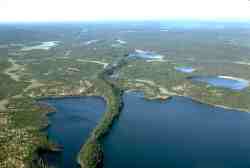
Eskers are long narrow sinuous ridges made up of highly porous gravel and sand found where the subglacial meltwater streams existed. As shown in Figure \(\PageIndex{3}\), they are depositional features and are observed as a glacier retreats. The winding (sinuous) shape of an esker mirrors the meandering path of the ancient subglacial river that formed it. Figure \(\PageIndex{4}\) shows the winding shape of an esker. Meltwater streams have a lot of energy and can carry and sort a lot of sediment. As the water deposits its load, it leaves behind sorted, stratified sediments like sand and gravel, which are highly porous. Water rapidly drains from their crests so they do not support heavy tree growth. Mason Esker in Michigan, USA is an example of an esker. Eskers are good sources for sand and gravel, and many of them have been destroyed by mining for these materials.
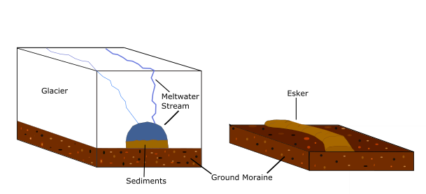
Figure \(\PageIndex{3}\) shows how an esker forms beneath a glacier and what remains after the glacier melts.
Left panel: Esker formation beneath a glacier - A large block of ice labeled Glacier rests on the landscape. Beneath the glacier, a channel labeled Meltwater Stream carries flowing meltwater through or under the ice. The meltwater stream deposits layers of sediments composed mainly of sand and gravel within the channel. Because the stream is confined beneath the glacier, the sediment accumulates in a long, narrow ridge-shaped deposit.
Right panel: Esker exposed after ice retreat - After the glacier melts away, the sediment deposited by the subglacial stream remains as a raised, winding ridge labeled Esker. The surrounding landscape is covered by Ground Moraine, a blanket of unsorted glacial sediment left behind by the ice. The esker stands above the surrounding ground because the sand and gravel deposited by the meltwater stream remain in place after the ice disappears.
Kames and Kettle Lakes
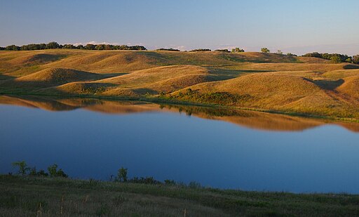
Kames are small rounded hills of gravel and sand that cover parts of a plain. Some kames form in holes in the ice where sediment accumulates. A mound of glacial drift is left behind once the ice melts. Here deposition occurs in the form of alternating ridges and depressions. Kettle Lakes form in these depressions and may not be occupied by water. They form when an isolated block of ice is surrounded by till or stratified drift. After a period of time the ice block melts away leaving behind a hole in the surface. Kettles are often found on outwash plains or embedded in moraines (hence the name for Kettle Moraine State Forest in Wisconsin). Figure \(\PageIndex{5}\) illustrates a landscape with Kames and Kettle lake.
Erratics
Glacial erratics shown in Figure \(\PageIndex{6}\) are depositional features created by the action of glaciers. A glacier's immense mass and erosive power enable it to pick up and transport large fragments of rock, including huge boulders, sometimes over vast distances. As the climate warms, the glacier melts and recedes, depositing its sediment load. These transported boulders are termed "erratics" because the composition of the deposited rock is different from the bedrock and local native rocks of the area where they are found, indicating they originated elsewhere.

Outwash
The process of outwash formation begins when water melting from a glacier transports its sediment load (glacial drift). As this meltwater flows across the ground surface, its velocity decreases, reducing the energy available to carry the material. This causes the progressive deposition of sediment. The constant fluctuation in water speed ensures the drift is meticulously sorted and layered—a characteristic known as stratification. Furthermore, these streams, which are commonly overburdened with sediment, are forced to continuously deposit and reroute around bars, resulting in the formation of distinctive braided stream networks within the outwash plain. Figure \(\PageIndex{7}\) illustrates the different features like moraine and outwash that are revealed as the glacier retreats.

Figure \(\PageIndex{7}\): Features created by a glacier. (Public Domain; National Parks Gallery).
Figure \(\PageIndex{7}\) is a three-dimensional block model showing a retreating valley glacier and the depositional landforms created as the ice melts.
At the upper right is a glacier labeled Glacier Front. An arrow labeled Glacial Retreat indicates that the glacier is shrinking and moving back upslope. Several crevasses are visible on the glacier surface.
Along the sides of the glacier are ridges labeled Lateral Moraine, formed from rock debris deposited along the glacier margins. At the former edge of the glacier is a ridge labeled Terminal Moraine, marking the furthest advance of the glacier before retreat began.
In front of the glacier is a broad area of sediment and braided meltwater channels. This area is labeled Outwash Sand and Gravel and represents an outwash plain formed by meltwater streams carrying and sorting glacial sediment. Numerous channels spread across the plain, illustrating the braided nature of glacial meltwater streams.
Near the glacier margin, a label Recent outwash over bedrock identifies newly deposited sediment resting directly on exposed rock surfaces.
Beneath much of the landscape is a layer labeled Ground Moraine, a blanket of unsorted glacial sediment deposited beneath the ice as it melted. On the right side, the underlying Bedrock is visible beneath the moraine and outwash deposits.
Moraine
Moraines are made up of material eroded by a glacier, materials weathered by frost action, and materials carried within it and brought down the valley. A moraine is a glacially formed accumulation of unconsolidated debris. Moraines often take the form of a belt of low hills composed of till. Figure \(\PageIndex{8}\) illustrates the different types of moraines. Materials deposited on the side of a glacier are called lateral moraines. When two glaciers converge, lateral moraines converge to form medial moraines. Often, uplands will cause an ice sheet to separate into lobes. Interlobate moraines form between lobes of the ice sheet. Ground moraines are unconsolidated material deposited along the floor of the glacier as it melts. Wetland areas are often created in ground moraine which is a convenient way of identifying them from a topographic map.At the leading edge of the glacier, end moraine can be found. A terminal moraine is an end moraine that marks the furthest advance of the ice sheet.When end moraines are deposited in succeeding waves, recessional moraines are formed.
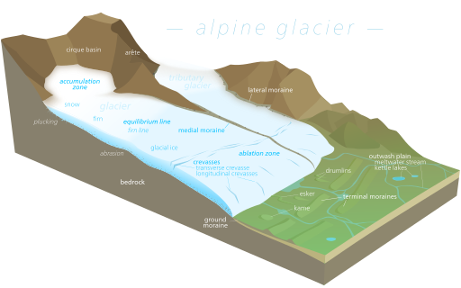
Figure \(\PageIndex{8}\) is a three-dimensional block model of an alpine glacier and the major erosional and depositional landforms associated with glaciation.
At the upper left, the glacier originates in a bowl-shaped cirque basin surrounded by steep mountain walls. A sharp ridge labeled arête separates adjacent glacial valleys. The upper portion of the glacier is labeled the accumulation zone, where snowfall exceeds melting and snow gradually compacts into firn and then glacial ice.
A blue line labeled equilibrium line marks the boundary between the accumulation zone and the lower ablation zone, where melting exceeds snowfall.
The glacier flows downslope through a mountain valley. Along the valley sides are deposits labeled lateral moraines, formed from rock debris carried along the glacier margins. Where a tributary glacier joins the main glacier, their lateral moraines merge to form a medial moraine running down the center of the ice.
Several crevasses are shown on the glacier surface, including transverse and longitudinal crevasses created by ice movement and stress.
Beneath the glacier, the bedrock is modified by two major erosional processes:
- Plucking, which removes rock fragments from the valley walls and floor.
- Abrasion, which grinds and smooths the bedrock as rock fragments embedded in the ice scrape across the surface.
As the glacier reaches lower elevations and melts, it leaves behind a variety of depositional landforms:
- Ground moraine, a blanket of sediment deposited beneath the ice.
- Terminal moraines, ridges of till marking former positions of the glacier margin.
- Drumlins, streamlined hills aligned with former ice flow.
- Eskers, winding ridges of sand and gravel deposited by subglacial meltwater streams.
- Kames, irregular hills of sand and gravel deposited by meltwater.
- Kettle lakes, depressions formed by melting blocks of buried ice.
- Outwash plain, a broad area of sediment deposited by braided meltwater streams flowing away from the glacier.