

12.3: Depositional Forms
- Page ID
- 42710

\( \newcommand{\vecs}[1]{\overset { \scriptstyle \rightharpoonup} {\mathbf{#1}} } \)
\( \newcommand{\vecd}[1]{\overset{-\!-\!\rightharpoonup}{\vphantom{a}\smash {#1}}} \)
\( \newcommand{\dsum}{\displaystyle\sum\limits} \)
\( \newcommand{\dint}{\displaystyle\int\limits} \)
\( \newcommand{\dlim}{\displaystyle\lim\limits} \)
\( \newcommand{\id}{\mathrm{id}}\) \( \newcommand{\Span}{\mathrm{span}}\)
( \newcommand{\kernel}{\mathrm{null}\,}\) \( \newcommand{\range}{\mathrm{range}\,}\)
\( \newcommand{\RealPart}{\mathrm{Re}}\) \( \newcommand{\ImaginaryPart}{\mathrm{Im}}\)
\( \newcommand{\Argument}{\mathrm{Arg}}\) \( \newcommand{\norm}[1]{\| #1 \|}\)
\( \newcommand{\inner}[2]{\langle #1, #2 \rangle}\)
\( \newcommand{\Span}{\mathrm{span}}\)
\( \newcommand{\id}{\mathrm{id}}\)
\( \newcommand{\Span}{\mathrm{span}}\)
\( \newcommand{\kernel}{\mathrm{null}\,}\)
\( \newcommand{\range}{\mathrm{range}\,}\)
\( \newcommand{\RealPart}{\mathrm{Re}}\)
\( \newcommand{\ImaginaryPart}{\mathrm{Im}}\)
\( \newcommand{\Argument}{\mathrm{Arg}}\)
\( \newcommand{\norm}[1]{\| #1 \|}\)
\( \newcommand{\inner}[2]{\langle #1, #2 \rangle}\)
\( \newcommand{\Span}{\mathrm{span}}\) \( \newcommand{\AA}{\unicode[.8,0]{x212B}}\)
\( \newcommand{\vectorA}[1]{\vec{#1}} % arrow\)
\( \newcommand{\vectorAt}[1]{\vec{\text{#1}}} % arrow\)
\( \newcommand{\vectorB}[1]{\overset { \scriptstyle \rightharpoonup} {\mathbf{#1}} } \)
\( \newcommand{\vectorC}[1]{\textbf{#1}} \)
\( \newcommand{\vectorD}[1]{\overrightarrow{#1}} \)
\( \newcommand{\vectorDt}[1]{\overrightarrow{\text{#1}}} \)
\( \newcommand{\vectE}[1]{\overset{-\!-\!\rightharpoonup}{\vphantom{a}\smash{\mathbf {#1}}}} \)
\( \newcommand{\vecs}[1]{\overset { \scriptstyle \rightharpoonup} {\mathbf{#1}} } \)
\(\newcommand{\longvect}{\overrightarrow}\)
\( \newcommand{\vecd}[1]{\overset{-\!-\!\rightharpoonup}{\vphantom{a}\smash {#1}}} \)
\(\newcommand{\ket}[1]{\left| #1 \right>}\)
\(\newcommand{\bra}[1]{\left< #1 \right|}\)
\(\newcommand{\braket}[2]{\left< #1 \vphantom{#2} \right| \left. #2 \vphantom{#1} \right>}\)
\(\newcommand{\braopket}[3]{\left< #1 \vphantom{#2}\vphantom{#3} \right| #2 \vphantom{#1}\vphantom{#3} \left| #3 \vphantom{#1}\vphantom{#2} \right>}\)
\(\newcommand{\qmvec}[1]{\mathbf{\vec{#1}}}\)
\(\newcommand{\op}[1]{\hat{\mathbf{#1}}}\)
\(\newcommand{\expect}[1]{\langle #1 \rangle}\)
\(\newcommand{\dfn}[1]{\emph{\textbf{#1}}}\)
Dunes
A sand dune is an accumulation of loose sand grains piled up by the wind. Dunes are most likely to form where winds are strong and generally blow from the same direction. Some of the most extensive dune fields are found in the world's great deserts like the Sahara. The dune fields of these great sandy deserts are called sand seas. Patches of dunes are found in the southwest desert of the United States. Ancient dune fields are found in regions that were dry in the past but now exhibit a more humid climate. Dune systems are found landward of beaches where sand is blown landward. Beach dunes are common along the coasts of the world's oceans and large lakes like the Great Lakes of North America.
Dune formation
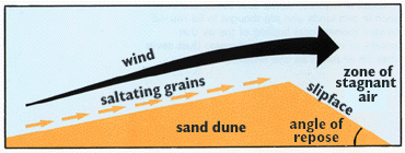
Figure \(\PageIndex{1}\) illustrates the movement of sand in a dune environment. Wind blows from left to right across a sand dune. Sand grains move up the windward side by saltation, a series of short hops driven by the wind. At the dune crest, the wind slows and sand accumulates before moving down the steep leeward slope, known as the slip face. The slip face is maintained at the angle of repose, the steepest angle at which sand remains stable. Behind the crest, a zone of relatively stagnant air develops. The process of erosion on the windward side and deposition on the leeward side causes the sand dune to migrate in the direction of the wind.
Dunes are primarily made up of accumulated sand grains. Finer silt and clay are carried further by the wind leaving the heavier sand grains behind. Generally, a dune forms an asymmetric cross-sectional form with a gentle windward or "stoss" slope and an steep leeward slope called the slip face. Saltating grains move up the windward slope and then come to rest at their angle of repose on the downwind side in a zone of stagnant air.
Dune types

Barchans, also spelled barkhans, are active, crescent-shaped sand dunes that develop individually or in groups across arid regions lacking vegetation, most notably in the Sahara and Turkestan deserts. They typically begin by chance when sand accumulates against a minor obstacle like a patch of grass or a heap of rocks. Positioned transversely to the wind, a barchan features a convex, gently sloping windward side and a steep, concave leeward side known as the slip-face. Because wind experiences less frictional resistance around the edges of the dune, the outer margins move faster, causing the elongated tips or horns to thin out and point directly downwind. When these dunes are perfectly symmetrical, it indicates that the prevailing winds are blowing from a constant, unchanging direction.
The migration of a barchan is a continuous process driven by the wind. Sand grains are pushed up the gentle windward slope and, upon reaching the crest, slide down the steep leeward face, causing the entire dune to advance across non-sandy surfaces of gravel or clay. The speed of this advancement is closely tied to the size of the dune. Smaller dunes that stand only a dozen meters high travel faster, covering about fifteen meters or fifty feet a year. Conversely, massive high dunes measuring up to thirty meters or one hundred feet tall move more slowly, advancing at a rate of roughly eight meters or twenty-five feet per year.
This steady movement can present a serious threat to desert life and communities. Migrating barchans frequently encroach upon oases, where they can completely bury houses, palm trees, and vital agricultural land. To combat this destruction and halt the encroaching sand, long-rooted trees and specialized sand-holding grasses are planted to stabilize the ground and block the advance. Furthermore, under the influence of fluctuating winds, barchans can lose their neat symmetry and dissolve into a chaotic, ever-changing pattern. Multiple dunes often collide and merge into long, irregular ridges. These vast, shifting sandy deserts, known as ergs, are constantly reshaped by the wind, making them incredibly difficult and treacherous to navigate.
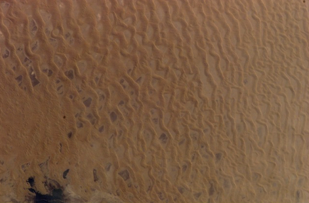
Transverse dunes are large, elongated ridges of sand that establish themselves perpendicular to the direction of the prevailing wind. They develop in environments with an abundant supply of loose, well-sorted sand that ranges from very fine to medium in texture. Geologically, these expansive structures form when multiple individual barchan dunes migrate together, merge, and align into continuous, sweeping lines. This phenomenon is famously visible in massive dune fields like the Great Sand Dunes National Park, where vast quantities of sand accumulate at the base of mountain barriers.
The structural profile of a transverse dune is highly asymmetrical, defined by two distinct slopes shaped entirely by wind dynamics. The windward side, also known as the stoss slope, faces the incoming airflow and features a very gentle, gradual incline that is typically less than 15 degrees. Wind steadily pushes the loose sand grains up this long slope until they reach the crest. Once the accumulation passes the peak, it reaches its angle of repose and collapses down the sheltered leeward side. This backside, called the slip face, is remarkably steep, holding a sharp angle of roughly 32 degrees as the sand cascades downward.
Parabolic dunes are U-shaped sand formations characterized by elongated arms or horns that point backward, directly into the prevailing upwind direction. Unlike dunes that thrive in completely dry, barren environments, these structures develop in areas that feature a mix of moisture and specialized vegetation, such as the expansive sand sheets surrounding Great Sand Dunes National Park.
The unique U-shape of a parabolic dune is a direct result of how wind interacts with plants and damp ground. As the wind blows sand across the landscape, the vegetation and moisture anchor the base and the lower outer edges of the mound, significantly dragging down their movement. Meanwhile, the dry, unanchored sand at the crest faces no such resistance, allowing the top center of the dune to break free and migrate forward. This causes the central body of the dune to advance downwind while the anchored arms are left trailing behind upwind. Over time, these stabilized formations slowly migrate across the landscape, often traveling toward larger, central dune fields.

Blowout dunes form from sand deposited at the end of an open-ended deflation hollow. Blowout dunes are common to many sandy coasts (coastal blowout dunes). The deflation hollow focuses the wind toward the center of the depression causing the sand to migrate landward as a dune. With little wind energy on the side of the hollow, the tails of the dune move much slower. As a result, beach plants like dune grass, sea oats or sand cherry can find a suitable habitat to flourish in. Once established, the plants help anchor the flanks to promote the formation of the characteristic parabolic shape.
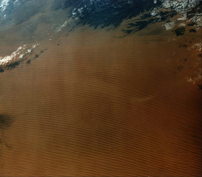
Longitudinal dunes form where wind blows from more than one direction in a region with an abundant supply of sand. In some places longitudinal dunes form long smooth "whalebacks', while in other regions they display knife-edged crests. Unlike transverse dunes, these do not migrate, but lengthen in size over time. Seifs are elongate dunes that resemble great windrows of sand. They form parallel to the direction of the wind, though are a product of shifting wind direction. The changing wind direction sends sand back and forth across the dune crest leaving a sharp knife-like profile.
Star dunes are pyramidal-shaped mounds of sand with slipfaces on three or more arms radiating from the center and common to ergs. They tend to accumulate in areas where the wind comes from several different directions. Star dunes grow vertically rather than laterally.
Ergs
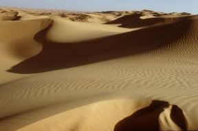
Individual sand seas are referred to as ergs. Small ergs are present in most desert regions. North Africa and the Arabian desert contain the most spectacular forms on Earth with waves of sand covering tens of thousands of square kilometers. Ergs are also found in India, western China, and Australia. The Sand Hills of Nebraska are remnants of an ancient sand sea.
Loess
When we look at eolian landscapes, loess stands out as a fascinating windblown sedimentary deposit. Composed mostly of fine, unstratified silt grains loosely held together by clay or calcium carbonate, it typically originates during glacial periods. Strong winds sweep across barren, dry terrains to pick up fine rock flour from glacial outwash plains, though it can also blow in from hyper-arid desert basins. Because the silt particles are incredibly uniform in size and densely packed, loess possesses a high degree of vertical porosity. This internal structure gives the material a striking mechanical property: vertical cleavage. This is why we see it maintain remarkably stable, near-vertical walls and cliffs when cut by rivers or roads, even though the material itself is soft enough to dig into easily with basic hand tools.
From a regional perspective, loess blankets vast areas of the globe and directly drives agricultural productivity thanks to its rich mineral content and excellent water-retaining capabilities. The most massive accumulations on Earth are found on the Loess Plateau of China, where windblown material from the Gobi Desert has piled up in strata hundreds of feet thick over millions of years. In North America and Europe, widespread loess sheets cover prime agricultural zones, like our own American Midwest and the fertile plains of Central Europe, dropped there during the retreat of Pleistocene ice sheets. However, because these deposits are highly vulnerable to water erosion once the stabilizing natural vegetation is cleared, managing loess landscapes remains a major soil conservation challenge.
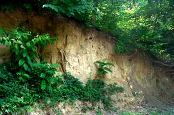
As glaciers advanced across North America they ground the underlying rock into a powder-like "glacial flour". This sediment is laid down by glacial melt water and later eroded from the dry deposit by strong wind. The Loess Hills of Iowa and Loess Plateau of China are two well-known examples of loess topography.
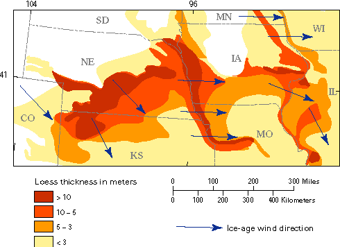
Figure \(\PageIndex{8}\) is a map that shows the distribution and thickness of loess deposits across parts of Colorado, Nebraska, Kansas, South Dakota, Minnesota, Iowa, Missouri, Illinois, and Wisconsin. Loess thickness is grouped into four classes: less than 3 meters, 3 to 5 meters, 5 to 10 meters, and greater than 10 meters. The thickest deposits, exceeding 10 meters, occur in elongated bands along portions of the Missouri and Mississippi River valleys. Surrounding these areas are progressively thinner zones of loess, indicating that sediment thickness decreases with distance from the source regions. Blue arrows labeled “Ice-age wind direction” show prevailing winds that transported fine sediment across the region. The pattern demonstrates that wind-blown silt was carried from glacially influenced river valleys and deposited over broad areas of the Midwest, creating extensive loess deposits that became thinner farther from the source.