

10.5: Landforms created by running water
- Page ID
- 42705

\( \newcommand{\vecs}[1]{\overset { \scriptstyle \rightharpoonup} {\mathbf{#1}} } \)
\( \newcommand{\vecd}[1]{\overset{-\!-\!\rightharpoonup}{\vphantom{a}\smash {#1}}} \)
\( \newcommand{\dsum}{\displaystyle\sum\limits} \)
\( \newcommand{\dint}{\displaystyle\int\limits} \)
\( \newcommand{\dlim}{\displaystyle\lim\limits} \)
\( \newcommand{\id}{\mathrm{id}}\) \( \newcommand{\Span}{\mathrm{span}}\)
( \newcommand{\kernel}{\mathrm{null}\,}\) \( \newcommand{\range}{\mathrm{range}\,}\)
\( \newcommand{\RealPart}{\mathrm{Re}}\) \( \newcommand{\ImaginaryPart}{\mathrm{Im}}\)
\( \newcommand{\Argument}{\mathrm{Arg}}\) \( \newcommand{\norm}[1]{\| #1 \|}\)
\( \newcommand{\inner}[2]{\langle #1, #2 \rangle}\)
\( \newcommand{\Span}{\mathrm{span}}\)
\( \newcommand{\id}{\mathrm{id}}\)
\( \newcommand{\Span}{\mathrm{span}}\)
\( \newcommand{\kernel}{\mathrm{null}\,}\)
\( \newcommand{\range}{\mathrm{range}\,}\)
\( \newcommand{\RealPart}{\mathrm{Re}}\)
\( \newcommand{\ImaginaryPart}{\mathrm{Im}}\)
\( \newcommand{\Argument}{\mathrm{Arg}}\)
\( \newcommand{\norm}[1]{\| #1 \|}\)
\( \newcommand{\inner}[2]{\langle #1, #2 \rangle}\)
\( \newcommand{\Span}{\mathrm{span}}\) \( \newcommand{\AA}{\unicode[.8,0]{x212B}}\)
\( \newcommand{\vectorA}[1]{\vec{#1}} % arrow\)
\( \newcommand{\vectorAt}[1]{\vec{\text{#1}}} % arrow\)
\( \newcommand{\vectorB}[1]{\overset { \scriptstyle \rightharpoonup} {\mathbf{#1}} } \)
\( \newcommand{\vectorC}[1]{\textbf{#1}} \)
\( \newcommand{\vectorD}[1]{\overrightarrow{#1}} \)
\( \newcommand{\vectorDt}[1]{\overrightarrow{\text{#1}}} \)
\( \newcommand{\vectE}[1]{\overset{-\!-\!\rightharpoonup}{\vphantom{a}\smash{\mathbf {#1}}}} \)
\( \newcommand{\vecs}[1]{\overset { \scriptstyle \rightharpoonup} {\mathbf{#1}} } \)
\(\newcommand{\longvect}{\overrightarrow}\)
\( \newcommand{\vecd}[1]{\overset{-\!-\!\rightharpoonup}{\vphantom{a}\smash {#1}}} \)
\(\newcommand{\ket}[1]{\left| #1 \right>}\)
\(\newcommand{\bra}[1]{\left< #1 \right|}\)
\(\newcommand{\braket}[2]{\left< #1 \vphantom{#2} \right| \left. #2 \vphantom{#1} \right>}\)
\(\newcommand{\braopket}[3]{\left< #1 \vphantom{#2}\vphantom{#3} \right| #2 \vphantom{#1}\vphantom{#3} \left| #3 \vphantom{#1}\vphantom{#2} \right>}\)
\(\newcommand{\qmvec}[1]{\mathbf{\vec{#1}}}\)
\(\newcommand{\op}[1]{\hat{\mathbf{#1}}}\)
\(\newcommand{\expect}[1]{\langle #1 \rangle}\)
\(\newcommand{\dfn}[1]{\emph{\textbf{#1}}}\)
River Courses, Stream Types, and Fluvial Landforms
The source of a river maybe a glacier, lake, spring or marsh but it is generally an upland region where precipitation is high and the river flows down following the slope of the land pulled by gravity. The natural downward slope of the land transports water from higher elevations to lower ones eventually reaching its mouth forming deltas or estuaries. It is this movement along the slope that drives the entire river system. Figure \(\PageIndex{1}\) classifies the different types of streams based on their direction of flow.

Figure \(\PageIndex{1}\) illustrates four types of streams classified by their relationship to topography and geologic structure: consequent, subsequent, resequent, and obsequent streams.
A large stream labeled Consequent Stream flows diagonally across the center of the figure. Arrows within the channel indicate flow in the downslope direction. Consequent streams are the first streams to develop on a newly formed landscape and generally follow the original slope of the land. Several smaller streams connect to the consequent stream:
- A Subsequent Stream enters from the upper right side of the diagram. It flows along zones of weaker rock or structural weaknesses rather than following the original slope.
- Another Subsequent Stream is shown in the lower portion of the figure, also flowing along a structurally controlled path before joining the main drainage system.
- A Resequent Stream appears on the left side. Its flow direction is generally the same as that of the original consequent stream, but it develops later as the drainage network expands.
- An Obsequent Stream is shown on the lower right. Arrows indicate that it flows in the opposite direction to the original consequent drainage, often developing through erosion on adjacent slopes.
The arrows throughout the diagram indicate stream flow directions and demonstrate how the various stream types are connected within a drainage network.
The figure shows how stream systems evolve over time in response to topography and underlying geologic structure. It distinguishes streams that follow the original land slope (consequent and resequent) from those controlled by structural weaknesses (subsequent) and those that flow opposite to the original drainage direction (obsequent). Together, these stream types illustrate the progressive development and complexity of drainage networks.
Consequent stream is the initial stream that exists as a consequence of the slope of the land. It is the first slope to form and the direction of flow follows the dip of the strata. It is often considered as the first stream to form in a region like a fold or a coastal plain and follows the path with least obstacles. As the consequent stream flows down slope, it erodes the surface and deepens the channel downwards. Subsequent stream develops after the consequent stream and are considered tributary streams that join the consequent stream obliquely or at right angles. This stream flows along a weak rock layer, creating a valley that runs parallel to the rock's tilt or fold. The angle at which they join the consequent stream depends on the alignment of hard and soft rocks. Obsequent stream flows opposite to the direction if the consequent stream where the stream carves its own valley through headward erosion. These streams flow against the original slope of the land. Resequent stream follows the same slope as the consequent stream but it develops after the consequent stream and at a lower elevation. Such streams commonly develop when new surfaces are exposed after a second cycle of erosion. Insequent streams are streams that develop randomly on homogeneous landscapes with no relation to the geology of the land. Such streams commonly appear erratic.

Figure \(\PageIndex{2}\) shows a river's longitudinal profile from its steep upper course near the source to its gentle lower course at the sea. The upper course has the steepest gradient and is dominated by erosion. Typical landforms include interlocking spurs, gorges, rapids, waterfalls, and river capture features.
In the middle course, the gradient becomes gentler and transportation is the dominant process. Common landforms include meanders, river cliffs, and floodplains.
In the lower course, the river has a very low gradient and deposition becomes the dominant process. Characteristic landforms include oxbow lakes, levees, floodplains, and deltas.
The diagram illustrates the downstream transition from erosion to transportation to deposition as the river approaches sea level.
As illustrated in Figure \(\PageIndex{2}\), the course of a river maybe divided into three distinct parts which are upper or mountain course, middle or valley course and lower or plain course. In these courses, the rivers energy and water flow varies and thus we see different types of features predominate. In the upper course, the river starts. It is normally in a high elevation region with high precipitation. In this region, the rivers energy is high aided by the slope of the land. In this stage of the river, it carves out its V shaped valley and mostly creates erosional features like waterfalls. From the mountains the river moves into the valleys. In this area the slope reduces however the river water increases as it is joined by tributaries. In this stage the river carves out a wider V shaped valley and has the available water to transport the sediments eroded by it. Meanders are common in the middle course of a river. The lower course of the river is when the river enters its plain course. In this stage the slope of the land is the least and the river's energy is least. In this stage it primarily deposits the sediments carried by it. So in this stage depositional features like flood plains, levees, ox-bow lakes and deltas predominate.
From its source in the watershed the river swiftly descends down slope under the influence of gravity by eroding and carving itself a V shaped valley along which it flows. In this stage erosion is predominant and vertical erosion occurs more rapidly than lateral erosion. When the river encounters very resistant rocks, the rate of down cutting is still greater than lateral erosion, which results in a very narrow, steep-sided valley.
Rapids and waterfalls

Figure \(\PageIndex{3}\) illustrates how rapids form when a river flows across alternating layers of soft rock and hard rock.
A river channel slopes downward from left to right across a landscape composed of bands of soft rock interrupted by several narrower bands of hard rock. The harder rock layers are labeled and appear as resistant ridges crossing the path of the river.
At each location where the river encounters a hard rock layer, a label “Rapids” marks a sudden increase in channel gradient. Curved arrows indicate water flowing rapidly downhill over these resistant rock outcrops.
The softer rock surrounding the hard rock erodes more quickly because it is less resistant to weathering and stream erosion. The hard rock erodes more slowly and remains elevated above the surrounding channel bed.
As erosion removes the softer rock on either side, the hard rock forms a step or ledge in the river profile. Water flowing over these steps becomes turbulent, creating rapids.
The diagram demonstrates that rapids develop because of differential erosion. Softer rock is worn away more rapidly than harder, more resistant rock. The resistant rock forms irregular steps in the stream bed, increasing water velocity and turbulence as water flows over them. Rapids are therefore common where rivers cross alternating layers of rock with different resistance to erosion and often represent temporary interruptions in a river's longitudinal profile.
Rapids are sections of a river where water flows with increased velocity and turbulence due to the steep gradient of the river bed. Air bubbles often mix with this fast moving water giving it a white appearance. As shown in Figure \(\PageIndex{3}\), rapids are common in areas with alternating hard and soft layers with soft layers eroding fast and hard rocks forming an uneven riverbed. While the steep gradient causes the water to flow fast, obstacles like rocks and boulders on the river bed force the river to flow around them creating waves, eddies and other turbulent features. When a rivers channel narrows, the water is forced to come out through a smaller area increasing its speed and pressure.

Figure \(\PageIndex{4}\) illustrates the formation and upstream retreat of a waterfall through differential erosion of hard and soft rock.
A horizontal layer of hard rock rests on top of a layer of soft rock. Water flows from left to right over the edge of the hard rock layer, forming a waterfall.
At the base of the waterfall, the soft rock is labeled “(1) Undercutting.” Here, falling water erodes the softer rock more rapidly than the resistant hard rock above it. This erosion creates a recessed notch or overhang beneath the hard rock layer.
Loose rock fragments are shown at the base of the waterfall, indicating that the unsupported hard rock eventually collapses into the plunge pool below. The collapsed material is then broken up and carried away by the river.
A curved arrow at the top points upstream, showing the direction in which the waterfall migrates over time. As repeated undercutting and collapse occur, the waterfall gradually retreats upstream and leaves behind a steep-sided gorge.
The diagram demonstrates how waterfalls form and retreat through differential erosion. Softer rock erodes faster than the overlying hard rock, producing undercutting, rock collapse, and upstream migration of the waterfall. This process deepens the channel and creates gorges commonly found in the upper course of rivers.
As illustrated in Figure \(\PageIndex{4}\), a waterfall forms when hard resistant rocks lie over soft rocks. The water flows over the hard rock and erodes the soft rocks underneath rapidly. Erosion happens simultaneously in two ways which are from the flow of the river and from the turbulence at the base of the drop. Rapid erosion of soft rocks create an overhang of hard resistant rocks. After erosion of the soft rock underneath, the overhang of resistant rock collapses into the riverbed. The force of the falling water along with the eroded debris erode under the waterfall creating a plunge pool. This alternating cycle of undercutting and collapse causes a waterfall to retreat and leave behind a gorge.

Waterfalls like Niagara Falls in U.S.A are formed when a bar of resistant rocks lie across a river valley. Sometimes a fault line scarp is caused by faulting lies across a river creating waterfalls like in the case of Victoria Falls on the Zambezi river in the border of Zambia and Zimbabwe. Often waterfalls are created when water flows down the edge of a plateau like Livingstone Falls formed by the Congo River. Waterfalls are created when water from tributary streams in hanging valleys flow into the main glacial U shaped valley which are at a lower elevation. Yosemite Falls in California is an example of such a waterfall.
Gorge
A narrow steep sided valley through which a river flows is called a gorge as shown in Figure \(\PageIndex{6}\). They are commonly found in areas with rapid river flow and steep slope. When a river flows over a hard rock lying on top of a soft rock. The river eventually flows over the resistant rock and rapidly erodes the soft rock under it creating a hollow or a plunge pool that is commonly found at the base of a waterfall. As the soft rock is eroded, the hard rock hangs unsupported above it. Eventually the hard rock collapses resulting in a steep sided gorge. Indus Gorge in Kashmir, India is an example of a Gorge.

Canyon
Down cutting and erosion by a river leads to the formation of a canyon. The process of canyon formation commonly starts with tectonic uplift. This uplift is key as it raises the elevation of the region thereby increasing the slope of the land. The rate of tectonic uplift must be more than the rate of down cutting by a river. The increased slope increases the fluvial energy enabling it to erode the soil and rocks it is flowing over. The eroded materials like gravel and sand provide the necessary tools for abrasion of the river valley making it deeper. This downward erosion is called down cutting. Resistant rocks like granite and sandstone erode slowly to form steep cliffs of the canyon walls. Soft rocks like shale and siltstone erode quickly creating gentler slopes and wider parts of the canyon. Differential erosion adds character to a canyon. While a river deepens the canyon other factors like weathering, rain, wind make the canyon wider and the eroded or weathered materials fall into the river under the influence of gravity and provide more tools to deepen its valley. Grand Canyon in Arizona, shown in Figure \(\PageIndex{7}\), has been created by the Colorado river.

River Capture
River capture is also knows as river piracy. River capture is a result of headward erosion or back-cutting into a divide. In order to explain the concept of river capture let us refer to Figure \(\PageIndex{8}\). In the figure we see a stream flowing from A to B and another stream coming from C. If the side with stream C has greater gradient and receives more precipitation, then headward erosion from C would be stronger eventually meeting the weaker stream going from A to B. The stream from C has greater erosive power and captures the stream going from A to B, changing its course and making it go from A to C. The course for the stream is changed as it gets captured. The stream flowing onward from B gets abandoned. The part of the captured stream that is no longer receiving water becomes a dry or significantly reduced flow channel, known as a wind gap or abandoned channel.

Figure \(\PageIndex{8}\) contains two three-dimensional block diagrams that illustrate the process of river capture (stream piracy).
Top diagram: Before river capture - Three stream segments are labeled A, B, and C.
- Stream A flows downhill and joins stream B.
- Stream C flows independently in a nearby valley.
- A drainage divide separates the two stream systems.
At this stage, the streams drain separate portions of the landscape, and the water from stream A flows into stream B.
Bottom diagram: After river capture - The second diagram shows a change in the drainage network.
- Headward erosion by stream C has cut through the drainage divide.
- Stream C has intercepted the upper waters of stream A.
- Water that previously flowed from A into B is now diverted into C.
- Stream B has lost part of its original drainage area and receives less water than before.
The capture point occurs where the channel of stream C has extended upstream far enough to divert the flow of stream A.
Interlocking Spurs
Interlocking spurs are ridges of land that protrude alternatively from opposite sides of a river valley as shown in Figure \(\PageIndex{9}\). This feature is commonly found in the upper course of a river when a river primarily takes part in vertical erosion. As the river moves down slope it tries to take a path of least resistance winding around resistant rocks. In this stage, the river uses the eroded materials as tools for down cutting but does not erode laterally. The winding course results in resistant rocks extending like fingers into the valley. From a distance, the Overlapping ridges interlock into each other.

Figure \(\PageIndex{9}\) illustrates interlocking spurs, a landform commonly found in the upper course of a river valley.
A river flows downhill through a narrow, steep-sided V-shaped valley. Rather than flowing in a straight line, the river winds around alternating projections of higher land that extend into the valley from opposite sides. These projecting ridges are labeled interlocking spurs.
Several valleys are shown branching from the main valley, and the river follows a sinuous path between the spurs. The valley walls are steep, indicating that vertical erosion is the dominant process.
At the bottom of the figure, labels identify the river bank, river bed, and sediment load. The sediment load consists of rock fragments and other material being transported along the channel bed.
The diagram shows how interlocking spurs form during the youthful stage of river development. In the upper course, a river has enough energy to erode downward rapidly but relatively little ability to erode laterally. As a result, the river follows the path of least resistance around ridges of more resistant material rather than cutting through them. This produces a winding channel that threads between alternating spurs projecting into the valley.
Interlocking spurs are therefore evidence of dominant vertical erosion and are characteristic features of steep, youthful river valleys.
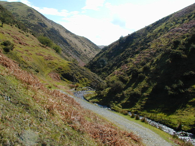
V-shaped Valley
In the upper course of a river, a river flows down slope and has a lot of energy. In this stage the river carves out a valley for itself and primarily down cuts its valley. The tools used for down cutting are the materials eroded by the river. The steep sides of the river bank are exposed to weathering and the weathered material comes down slope and falls into the river under the influence of gravity by the process of mass wasting. This results in a widened view of the valley from the top resulting in the V shape as shown in Figure \(\PageIndex{10}\). The characteristic steep walls of the river bed are because lateral erosion is less powerful than vertical erosion. As the river moves down slope and more tributaries join the river and increase its water flow, the V shape widens as lateral erosion predominates. In the lower course of the river, the river valley is the widest.
Alluvial Fan
When the river enters the valleys from the mountainous areas, the slope suddenly reduces. As a result of this, the energy of the river also goes down and the river deposits the materials that it eroded during its upper course. The material deposited by the river is called alluvium. It's an unconsolidated mix of sediments like clay, silt, sand, and gravel.This material is deposited in the shape of a fan and is thus called alluvial fan. From Figure \(\PageIndex{11}\) we see an alluvial fan between Kunlun and Altun mountains in the southern border of the Taklamakan Desert in China. The blue river channels in the left are the active parts of the fan. A bajada forms when several individual alluvial fans merge into one broadly sloping surface.

Meanders
Rivers that have reached base level develop broad valleys by erosion caused by meandering channels. The stream channel cuts through and redistributes its sediment or alluvium that lines the area bordering the stream. Figure \(\PageIndex{12}\) highlights some of the alluvial stream features where we see the river meandering.
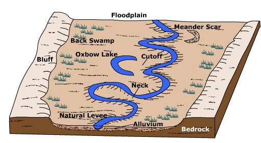
Figure \(\PageIndex{12}\) is a three-dimensional block model of a floodplain landscape showing several landforms created by a meandering river. A winding meandering river flows across a broad, flat floodplain. The channel curves back and forth across the valley floor, illustrating lateral migration of the river over time. Several floodplain features are labeled:
- Neck – a narrow strip of land separating two adjacent bends in the meander. Continued erosion across the neck can eventually create a cutoff.
- Cutoff – a new, shorter channel formed when the river breaches the neck of a meander and bypasses the loop.
- Oxbow Lake – a U-shaped water body left behind when a meander loop is cut off from the main channel.
- Meander Scar – a crescent-shaped depression marking the former location of a meander that has been abandoned and filled with sediment.
- Natural Levee – slightly elevated ridges alongside the river channel formed by repeated deposition of sediment during floods.
- Backswamp – a low-lying area behind the natural levees where water may collect and drainage is poor.
- Alluvium – unconsolidated sediment deposited by the river across the floodplain.
- Bluff – a steeper slope marking the edge of the floodplain.
- Bedrock – the solid rock underlying the alluvial deposits.
A meander is a bend in a stream. Vertical channel cutting is typical of the early stages of stream system evolution and hence, meandering channel pattern is negligible. However during later stages as base level is achieved and channel equilibrium is approached, lateral migration of the stream channel is more prevalent. Meanders grow both laterally and in the down stream direction. As water flows into a meander it takes on a helical or spiral flow which determines where erosion and deposition is concentrated. Centrifugal force draws water toward the outside bank (cut bank) causing erosion. Sediment eroded from the outside bank is deposited on the inside bank and transported downstream. In Figure \(\PageIndex{13}\) we can see that when meandering occurs there is simultaneous erosion and deposition occurring on opposite banks of the river based on whether it has slow currents or fast currents. This makes the meanders more pronounced.

Figure \(\PageIndex{13}\) illustrates how water velocity controls erosion and deposition in a meandering river.
The river channel follows a series of broad curves or meanders. Arrows within the channel show the direction of flow and indicate areas of fast current and slow current.
On the outside of each bend, the current is labeled fast current and the bank is labeled erosion. Here, water moves more rapidly and has greater energy, causing it to erode the river bank and create a steep cut bank or river cliff.
On the inside of each bend, the current is labeled slow current and the area is labeled deposition. Because water velocity is lower, sediment carried by the river settles out and accumulates to form a gently sloping point bar.
The lower part of the diagram shades the areas affected by these processes:
- Blue areas along the outside of bends show zones of erosion.
- Tan areas along the inside of bends show zones of deposition.
As erosion occurs on the outer banks and deposition occurs on the inner banks, the meanders gradually migrate across the floodplain and become larger over time.
Ox- Bow Lakes
As a meander becomes more pronounced, erosion makes the neck in between meander narrow and eventually join each other. Deposition isolates the bottom of the meandering loop and separates it from the main stream that flows away. river cut-off results in a portion of the river isolated from the new channel called an oxbow lake. Oxbow lakes are typically crescent shaped - like that of an oxbow. Groundwater seeping into the oxbow maintains the lake. Some oxbows will drain or silt up due to deposition during floods. The remnants of the oxbow is identified as a meander scar. Wetland and marshes are often found in the scar. Figure \(\PageIndex{14}\) illustrates the stages involved in the formation of an ox bow lake that have been explained in this section. Figure \(\PageIndex{15}\) is a photograph of the Murray river in Australia showing its meanders and ox-bow lake.

Figure \(\PageIndex{14}\) illustrates the formation of an oxbow lake through the progressive development of a meandering river. The process is shown in four stages.
- Meander becomes more pronounced - The river flows through a series of bends. Fast-moving water on the outside of each bend causes erosion, while slower-moving water on the inside of bends causes deposition of sediment. As erosion and deposition continue, the bends become larger and more curved.
- Simultaneous erosion and deposition continues - The meanders continue to enlarge. Erosion on the outer banks cuts laterally into the floodplain, while deposition on the inner banks builds point bars. The river channel becomes increasingly sinuous, and adjacent bends begin to approach one another.
- The neck narrows - Continued erosion at the outer banks reduces the width of the neck, the narrow strip of land separating two adjacent bends. As the neck becomes progressively narrower, the river channel is close to cutting through it.
- An oxbow lake is created - During a high-flow event or flood, the river cuts across the narrow neck, creating a new, shorter channel. The former meander loop is abandoned and becomes separated from the main river. The isolated, crescent-shaped water body is labeled ox-bow lake.

A neck is the upland between opposing meanders of a stream. A cutoff occurs when the neck between river meanders is eroded away and the meanders join to shorten the length of the channel. The slope of the channel increases as well when the river shortens its length.
As water rounds a meander, the water swings toward the outside bank where erosion is concentrated and then spirals toward the inside banks. As the water spirals toward the inside of the meander it is slowed by frictional drag imposed by the bed of the channel. This causes deposition of alluvium on the inside bank to form a bar. A point bar forms on the inside bank of a meander and rising from the channel as an accumulation of alluvium. As the channel meander continues to erode laterally, a succession of bars with intervening swales form called bar and swale topography.
Floodplain

A floodplain is the relatively flat area that borders a stream which is periodically inundated with water during high flow periods. When excess runoff causes the stream discharge to increase beyond the capacity of the channel, water spills out onto the floodplain. Increasing the cross-sectional area of stream flow causes a decrease in stream velocity. The resulting decrease in velocity causes sediment to deposit as alluvium on the floodplain. These alluvial deposits are often rich in nutrients and thus naturally fertilize floodplain soils. Floodplain agriculture has given rise to many of the great world civilizations.
Natural Levee
A natural levee is an narrow ridge of alluvium deposited at the side of the channel. During high discharge periods when the stream floods, coarse sediment settles out near the stream channel and grades to finer material further away. The over bank deposits of alluvium are often rich sources of nutrients for soils developed on the floodplain. Because floodplain soils are usually quite fertile, humans have inhabited them for years. To prevent flooding, artificial levees are built close to the channel, typically higher than natural levees. Confining the flood discharge to a small area increases the velocity of flow. The levees of the Mississippi River increase the flow velocity near the mouth as it enters the Gulf of Mexico. As a result, sediment is shot into the Gulf rather than being deposited near the mouth building the river's famous 'bird's foot' delta.
Stream Terrace
Stream terraces are elevated portions of a floodplain created when the stream down cuts and creates a new floodplain at a lower elevation. Stream terraces are important indicators of environmental change. Down cutting can be initiated by uplift of the land surface due to tectonic activity, increased flow, or a loss of sediment load.
Back swamp

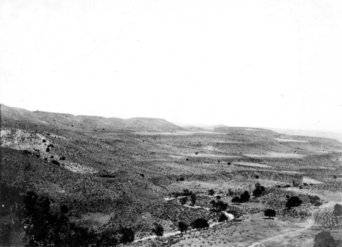
Back swamps are located some distance away from the stream channel on the floodplain. When water spills over onto the floodplain, the heaviest material drops out first and finest material is carried a greater distance. The fine grained alluvium holds much water and drains rather slowly creating wetland areas. Back swamps are important "sponges" that retain water that might cause severe flooding downstream.
Deltas
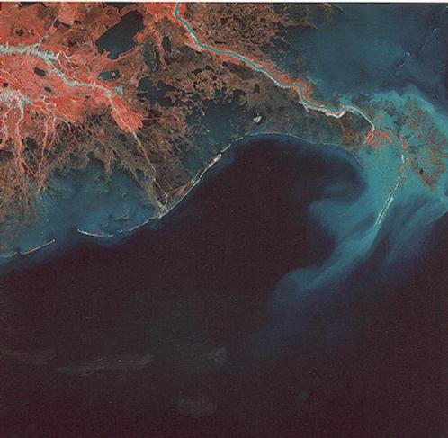
Deltas form by the deposition of sediment at the mouth of stream when water flows into a larger slow moving water body like a lake, sea or the ocean. Stream velocity decreases upon entering the ocean which causes the stream to deposit its load. Accumulation of sediment creates a low-lying plain that builds outwards. As a result of this accumulation the river channel splits into distributaries which meander around and enclose the deposits which form riverine islands. This landform resembles the triangular Greek letter Δ, thus it gets its name. The shape of a delta depends on a number of factors like the rate of sediment supply, wave action and coastal currents reworking the deposited sediment, and the rate at which the alluvial deposits subsides. It is common to find marshes around the delta area. Nile, Mississippi and Ganges-Brahmaputra all form deltas at their mouth. Not all rivers form a delta. Congo River, for example, does not form a delta. Not all rivers form deltas.
There are several reasons why a river does not form a delta.
- Strong ocean currents - Sometimes the receiving water body like ocean has powerful currents or tides that sweep away sediments into the sea or ocean faster than the rate at which the river deposits its sediments. The Narmada river in India does not form a delta due the existing high tidal range and strong currents in the Arabian Sea.
- Steep gradient - Rivers flowing through steep rocky terrain have high fluvial energy enabling the river to carry its sediments into the sea or ocean. The Western Ghats in India have the steep slopes enabling rivers flowing through them to carry sediments away and prevent the formation of deltas
- Low sediment load - Some rivers do not carry enough sediments required to form deltas
- Tectonic activity - Sometimes tectonic processes can cause the land at the river mouth to sink faster than sediment can accumulate, preventing delta formation.
- Water body near the mouth - If there is a lake near the mouth of a river, sediments maybe flushed into the lake reducing the sediment load carried by the river thus stopping the formation of a delta.
Playa
Though uncommon, when precipitation comes to the desert it can do so in torrential downpours sending a flash flood churning down dry streambeds known as a wash, arroyo or wadi depending on region. Salt encrusted soils result as water rapidly evaporates in the desert climate. A playa forms as an ephemeral lake in a low region of closed drainage. Permanent lakes and perennially running stream are rare in deserts. Many rivers are exotic streams, rivers whose head waters lie in a wetter region and the majority of which flows through a desert.