

7.5: Review and Additional Resources
- Page ID
- 42686

\( \newcommand{\vecs}[1]{\overset { \scriptstyle \rightharpoonup} {\mathbf{#1}} } \)
\( \newcommand{\vecd}[1]{\overset{-\!-\!\rightharpoonup}{\vphantom{a}\smash {#1}}} \)
\( \newcommand{\dsum}{\displaystyle\sum\limits} \)
\( \newcommand{\dint}{\displaystyle\int\limits} \)
\( \newcommand{\dlim}{\displaystyle\lim\limits} \)
\( \newcommand{\id}{\mathrm{id}}\) \( \newcommand{\Span}{\mathrm{span}}\)
( \newcommand{\kernel}{\mathrm{null}\,}\) \( \newcommand{\range}{\mathrm{range}\,}\)
\( \newcommand{\RealPart}{\mathrm{Re}}\) \( \newcommand{\ImaginaryPart}{\mathrm{Im}}\)
\( \newcommand{\Argument}{\mathrm{Arg}}\) \( \newcommand{\norm}[1]{\| #1 \|}\)
\( \newcommand{\inner}[2]{\langle #1, #2 \rangle}\)
\( \newcommand{\Span}{\mathrm{span}}\)
\( \newcommand{\id}{\mathrm{id}}\)
\( \newcommand{\Span}{\mathrm{span}}\)
\( \newcommand{\kernel}{\mathrm{null}\,}\)
\( \newcommand{\range}{\mathrm{range}\,}\)
\( \newcommand{\RealPart}{\mathrm{Re}}\)
\( \newcommand{\ImaginaryPart}{\mathrm{Im}}\)
\( \newcommand{\Argument}{\mathrm{Arg}}\)
\( \newcommand{\norm}[1]{\| #1 \|}\)
\( \newcommand{\inner}[2]{\langle #1, #2 \rangle}\)
\( \newcommand{\Span}{\mathrm{span}}\) \( \newcommand{\AA}{\unicode[.8,0]{x212B}}\)
\( \newcommand{\vectorA}[1]{\vec{#1}} % arrow\)
\( \newcommand{\vectorAt}[1]{\vec{\text{#1}}} % arrow\)
\( \newcommand{\vectorB}[1]{\overset { \scriptstyle \rightharpoonup} {\mathbf{#1}} } \)
\( \newcommand{\vectorC}[1]{\textbf{#1}} \)
\( \newcommand{\vectorD}[1]{\overrightarrow{#1}} \)
\( \newcommand{\vectorDt}[1]{\overrightarrow{\text{#1}}} \)
\( \newcommand{\vectE}[1]{\overset{-\!-\!\rightharpoonup}{\vphantom{a}\smash{\mathbf {#1}}}} \)
\( \newcommand{\vecs}[1]{\overset { \scriptstyle \rightharpoonup} {\mathbf{#1}} } \)
\(\newcommand{\longvect}{\overrightarrow}\)
\( \newcommand{\vecd}[1]{\overset{-\!-\!\rightharpoonup}{\vphantom{a}\smash {#1}}} \)
\(\newcommand{\ket}[1]{\left| #1 \right>}\)
\(\newcommand{\bra}[1]{\left< #1 \right|}\)
\(\newcommand{\braket}[2]{\left< #1 \vphantom{#2} \right| \left. #2 \vphantom{#1} \right>}\)
\(\newcommand{\braopket}[3]{\left< #1 \vphantom{#2}\vphantom{#3} \right| #2 \vphantom{#1}\vphantom{#3} \left| #3 \vphantom{#1}\vphantom{#2} \right>}\)
\(\newcommand{\qmvec}[1]{\mathbf{\vec{#1}}}\)
\(\newcommand{\op}[1]{\hat{\mathbf{#1}}}\)
\(\newcommand{\expect}[1]{\langle #1 \rangle}\)
\(\newcommand{\dfn}[1]{\emph{\textbf{#1}}}\)
Summary

Review and assess your learning. Start with the "Important Terms and Concepts" to ensure you know the terminology related to the topic of the chapter and concepts discussed. Move on to the "Review Questions" to answer critical thinking questions about concepts and processes discussed in the chapter. Finally, test your overall understanding by taking the "Self-assessment quiz".
-
- tectonic plates
- aka lithospheric or crustal plates; make up the surface of the lithosphere
-
- plate tectonics
- the process of plate formation, movement, and destruction
-
- continental drift
- the movements of continents over the Earth's surface
-
- sea-floor spreading
- the creation new oceanic plate material and movement away from the midocean ridge
-
- Pangea
- the one "super-continent"; the past configuration of the continents
-
- exotic terrain
- new land that has been formed somewhere else and moved to its present location
-
- midocean ridge
- the longest continuous mountain system on Earth
-
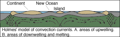
- mantle convection currents
- the mechanism that drives continental drift; created by heat trapped beneath the Earth's surface
-
- magnetic reversal
- a series of "flips" when the polarity of the rocks reversed
-
- subduction zone
- where more dense plates dive beneath lighter, less dense crustal plates
-
- spreading boundary
- occurs where plates are moving away (diverging) from one another
-
- convergent boundary
- located where subduction is active and the lithosphere is being "consumed". This occurs where two plates collide with one another
-
- transform boundary
- where plates are grinding past one another, like the San Andreas fault
-
- plate boundary zone
- broad belts in which boundaries are not well defined and the effects of plate interaction are unclear
-
- Ring of fire
- extends from the west coast of the United States toward the Aleutian Islands and over to Japan; a good example of volcano activity associated with the margins of plates
-
- strain
- change in shape as a result of imposing a stress
-
- elastic deformation
- Like a rubber band, if the stress is released before reaching the yield point, the rock material will return to its original shape
-
- brittle failure
- under low temperature and pressure conditions, once the rock reaches its yield point it will break; or if stress is imposed suddenly
-
- plastic deformation
- once the rock changes shape and if stress is released, it will not return to its original form
-
- folding
- occurs when rock is compressed, as it is along colliding plate boundaries
-
- anticline
- Upturned folds
-
- syncline
- down turned folds
-
- symmetrical fold
- near-vertical axial planes and gently dipping limbs of about the same angle are a product of gentle compression
-
- overturned fold
- If the compression is more pronounced from one direction
-
- recumbent fold
- When extreme directed pressure lay the fold over with its axial plane nearly horizontal with the surface
-
- fault
- a fracture along which movement occurs
-
- fault Plane
- The plane that extends into the earth and along which slippage occurs
-
- fault dip
- the angle from horizontal that the fault plane makes
-
- strike
- The map direction that the fault takes
-
- fault scarp
- The steep face of an exposed block
-
- fault line
- the trace of the fault along the surface
-
- strike slip fault
- aka transform fault; those that primarily exhibit horizontal movement
-
- dip slip fault
- those in which vertical displacement primarily occurs
-
- transform fault
- aka strike slip fault; those that primarily exhibit horizontal movement
-
- normal fault
- one in which the hanging wall falls down relative to the foot wall due to tensional stress
-
- reverse fault
- the hanging wall moves up relative to the foot wall due to compression
-
- graben
- forms when a block of rock falls between two faults
-
- horst
- forms between two normal faults when a block of rock in the middle remains stationary and the blocks on either side subside
-
- thrust fault
- a reverse fault at 45o angle
-
- volcano
- an opening in the surface of the Earth from which magma and associated gases and ash erupt; also, the form or structure, sometimes conical, that is produced by the ejected material.
-
- central vent
- The main conduit through which magma moves toward the surface
-
- crater
- sits at the top of a volcano and is the location where much of the lava, gas, rock fragments and ash are ejected from
-
- caldera
- massive craters created when pressure builds inside the volcano until the top is literally blown off, magma drains back into the central vent and the top of the cone collapses in
-
- magma chamber
- a huge, subterranean caldron of molten rock that is less dense than the surrounding rock and rises to the surface
-
- lava
- molten rock above the surface
-
- lateral vent
- found on the sides of some volcanoes where lava is extruded
-
- pyroclastic flow
- fast-moving gas and fragments of rock having temperatures of 500 oC rushing down the flanks of a volcano at speeds reaching 100 km/hr, carbonizing all in their path.
-
- hot spot
- places where a chamber of magma has accumulated at depth beneath the surface
-
- midocean Ridge
- oceanic plates are diverging and magma spreads across the ocean floor, ultimately being exposed at the surface
-
- effusive eruption
- those that create vast lava flows of low viscosity, fluid lava. Magma associated with effusive-type eruptions is relatively low in silica and thus "easily" flows up the vent and spreads across the surface
-
- shield volcano
- a product of effusive eruptions; as the fluid lava flows out onto the surface, it spreads out and cools into a broad, low-angled slope.
-
- Pahoehoe lava
- has a glistening, ropy like appearance as it moves and cools
-
- AA lava
- more pasty than pahoehoe and forms a sharp, clinkery, rough surface
-
- explosive eruption
- common to volcanoes with very viscous lava and high amounts of gas under pressure. Magma is high in silica, thus more viscous
-
- cinder cone
- primarily composed of layers of pyroclastic material built from rock fragments once lodged in the central vent of the volcano
-
- composite (Stratovolcano)
- produce explosive eruptions; form from alternating eruptions dominated by pyroclastics or lava; display layers of alternating flows
-
- lahar
- Mudflows or debris flows resulting from when hot pyroclastic material melts snowpacks, or fresh pyroclastic deposits are mobilized by heavy rains
-
- Nuees Ardentees
- noxious gases and fine particulate matter; aka "glowing clouds or avalanches"
What is plate tectonics.
- Answer
-
Plate tectonics is the theory that the surface is broken into several tectonic plates that are moving and interacting with one another to produce relief features of the Earth.
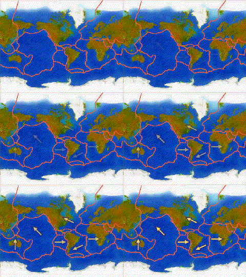
Courtesy USGS
What evidence was used to confirm the notion of continental drift?
- Answer
-
Similar configuration of continents, fossils, and geologic deposits widely separated from one another.
Where does sea flooring spreading occur? How have scienticts confirmed that sea floor spreading is taking place?
- Answer
-
Sea floor spreading occurs along the midocean ridge where new rock material is extruded onto the ocean floor. Magnetic stripes indicate similar polarity in rocks on either side of the ridge. The age of rocks increases away from the midocean ridge.
What drives the movement of tectonic plates?
- Answer
-
It is thought that convection currents in the mantle, the push of crustal rock as it is extruded along the midocean ridge, and the pull of slabs of crust at subduction zones are responsible for the movement of plates.
What is occurring along the midocean ridge?
- Answer
-
The midocean ridge is a primary site for sea floor spreading. As a result, earthquakes and volcanic activity is common.
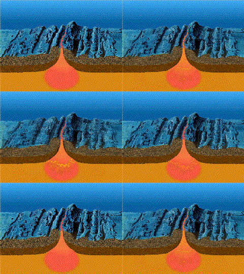
Sea floor spreading (Courtesy USGS)
What is a subduction zone, where do you find them, and what kinds of geological activity occurs there?
- Answer
-
A subduction zone is where crustal rocks are forced beneath the surface. Subduction is common where heavier, more dense ocean plates collide with lighter, less dense continental plates.
Compare and contrast the four main types of plate boundaries. Give examples of where they occur.
- Answer
-
A spreading boundary occurs where plates are moving away (diverging) from one another, like along the midocean ridge . Here, new crust is formed by accretion. A convergent boundary is found where subduction is active and the lithosphere is being "consumed". A transform boundary forms where plates are grinding past one another, like the San Andreas fault. A plate boundary zone is a broad belts in which boundaries are not well defined and the effects of plate interaction are unclear.
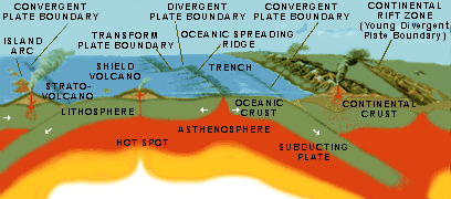
Tectonic Settings (Courtesy USGS)
What is the "Ring of Fire"?
- Answer
-
The "Ring of Fire" is "ring" of volcanoes encircling most of the Pacific ocean.

Ring of Fire (Courtesy USGS)
Describe elastic deformation, brittle failure, and plastic deformation.
- Answer
-
Elastic deformation: when stress is imposed on rock it deformed, when released it returns to its original shape. Brittle failure: breakage caused when stress is imposed beyond the rupture point of brittle materials. Plastic deformation: when stress is imposed on rock it deformed, when released it remains in its deformed shaped.
How does folding occur and what is the result?
- Answer
-
Folding occurs by compression of rock material. An up-turn fold is called an anticline while a down-turn fold is a syncline.
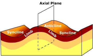
Compare and contrast the different kinds of faults.
- Answer
-
A dip slip fault exhibits vertical displacement. A normal fault is one in which the hanging wall falls down relative to the foot wall due to tensional stress. A reverse fault is one in which the hanging wall moves up relative to the foot wall due to compression. A thrust fault occurs when the hanging wall is pushed up and then over the foot wall at a low angle.
Compare and contrast shield, composite, and cinder cone volcanoes.
- Answer
-
Shield volcanoes have broad, low-angled slopes and built layer on layer of fluid lava. Composite volcanoes are steep-sided cones built from alternating flows of lava and pyroclastics. Cinder cones are smaller cones built primarily from explosive eruptions of pyroclastics.
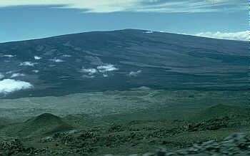
Shield Volcano (Photograph: D. Little; Courtesy USGS) 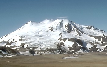
Composite Volcano (Photograph: R. McGimsey; Courtesy USGS) 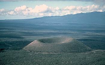
Cinder Cone (Photograph: J.P. Lockwood; Courtesy USGS


Where do volcanoes occur?
- Answer
-
In subduction zones, along the midocean ridge, and over hot spots.
What is the basic difference between eruptions from shield and composite volcanoes?
- Answer
-
Eruptions from shield volcanoes tend to be dominated by effusive eruptions of fluid lava. Composite volcanoes produces explosive eruptions from stickier magma.
What is a lahar?
- Answer
-
Mudflows called lahars are caused by the rapid melting and runoff of snow mixing with ash and soil.
What is a pyroclastic flow?
- Answer
-
Hot ash, pumice, rock fragments and noxious gas that moves rapidly down the side of a volcano.
What are the principal gases emitted by a volcano?
- Answer
-
The most common gas released by magma is steam (H2O), followed by CO2 (carbon dioxide), SO2 (sulfur dioxide), (HCl) hydrogen chloride and other compounds.
How do calderas form?
- Answer
-
By the volcano blowing the summit off or magma draining from the central vent removing support for the summit causing it to collapse in.
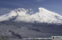
Mt. Saint Helens, Courtesy USGS
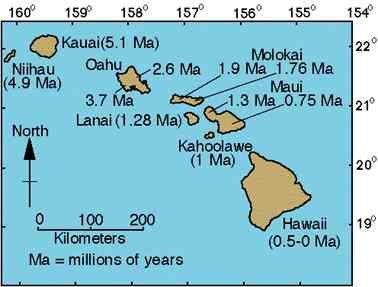
Explain how the Hawaiian Islands formed.
- Answer
-
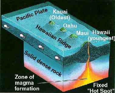
The Hawaiian islands were formed by volcanic activity over a hot spot. The youngest island in the chain lies toward the southeast as the Pacific Plate moves toward the northwest.
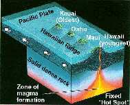
Hawaiian islands forming over hot spot (Source: USGS) 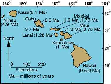
Age of Hawaiian Islands (Source: USGS)
How was the Columbia Plateau formed?
- Answer
-
A flood basalt of 170,000 cubic kilometers known as the Columbia River basalts covered a large portion of southeastern Washington, eastern Oregon and southern Idaho creating the plateau.
What is a volcanic neck?
- Answer
-
A volcanic neck is the "mold" of the central vent. Magma stuck in the central vent cools. Removal of the overlying rock exposes the plug-like shape within. Shiprock, NM (below) is a notable example of a volcanic neck.

- The original "super continent" was called
- Pangea
- Gondwanaland
- Nortreland
- none of the above
- Wegener proposed that continental crust "plowed" through _____ as it moved from one place to the next.
- oceanic crust
- the mantle
- the Moho
- none of the above
- In the late 1920's until the present, the movement of plates is thought to be due to
- convection currents in the crust
- convection currents in the mantle
- convection currents in the core
- earthquakes along subduction zones
- Along the Mid-ocean ridge
- earthquakes occur
- sea floor spreading occurs
- volcanism occurs
- all the above occurs
- Subduction zones are mostly likely found where
- ocean crust collides with ocean crust
- ocean crust collides with continental crust
- continental crust collides with continental crust
- where continental crust divergence takes place
- Which of the following boundaries characterize the San Andreas Fault?
- Spreading
- Convergent
- Transform
- None of the above
- Volcanism in Iceland is due to which of the following plate boundaries?
- Spreading
- Convergent
- Transform
- None of the above
- Volcanism on the Hawaiian Islands is due to which of the following plate boundaries?
- Spreading
- Convergent
- Transform
- None of the above
- The "Ring of Fire" is due to
- ocean crust colliding with ocean crust
- ocean crust colliding with continental crust
- continental crust colliding with continental crust
- where continental crust divergence takes place
- The longest continuous chain of mountains formed by tectonic processes is found
- in North America
- in South America
- in Asia
- on the ocean floor
- Volcanoes are found
- along the midocean ridge
- near subduction zones
- hot spots (mantle plumes)
- all of the above
- A volcano built by alternating flows of lava and accumulation of pyroclastics is called
- a shield volcano
- a cinder cones
- a composite volcano (stratovolcano)
- any of the above
- A caldera
- is a lateral vent on the side of a volcano
- a huge crater at the top of the volcano
- a tube where lava pours into the ocean
- none of the above
- The oldest island in the Hawaiian chain is located towards the ______ end of the chain.
- northwest
- northeast
- southwest
- southeast
- The volcanoes that comprise the Hawaiian Islands are
- shield volcanoes
- composite volcanoes
- cinder cones
- none of the above
- Shield volcanoes
- are associated with effusive eruptions
- have very steep sides
- mostly emit pyroclastic material from their central vent
- are associated with all the above
- ______ are mudflows due to rapid melting of snow packs along the sides of snow covered mountains.
- Pyroclastic avalanche
- Pahoehoe
- AA
- Lahars
- Devil's Tower is a
- dike
- lava plateau
- a landing site for alien spacecraft
- volcanic neck
- A lava that has a glistening, ropy-like appearance associated with effusive eruptions is known as
- AA
- Pahoehoe
- Nuees Ardentees
- Pu' u' O'o
- The Columbia River Plateau is was built from
- limestone
- granite
- basalt
- none of the above
- Answer
-
- A
- B
- B
- D
- B
- C
- A
- D
- B
- D
- D
- C
- B
- A
- A
- A
- D
- D
- A
- C
Additional Resources
- OpenAI. (2026). ChatGPT (GPT-4o version) [Large language model]. https://chatgpt.com
- Google. (2026). Gemini (Gemini 1.5 Pro version) [Large language model]. google.com
- merican Museum of Natural History. (n.d.). Harry Hess: One of the discoverers of seafloor spreading. Earth: Inside and Out.
- Britannica, T. Editors of Encyclopaedia. (2024, February 15). Continental Drift. Encyclopedia Britannica.
- Hawaiian Volcano Observatory. (2022, July 14). Volcano watch — What is a volcano? U.S. Geological Survey.
- Kious, W. J., & Tilling, R. I. (1996). This dynamic Earth: The story of plate tectonics. U.S. Geological Survey.
- National Geographic Society. (2022, May 20). Continental drift. National Geographic Education.
- National Geographic Society. (n.d.). Seafloor spreading.
- National Oceanic and Atmospheric Administration. (n.d.). Seafloor spreading. NeMO Explorer.
- National Park Service. (2020, December 28). Plate tectonics (Older version). U.S. Department of the Interior.
- NOAA Ocean Exploration. (2024, August 21). What are the different types of plate tectonic boundaries? National Oceanic and Atmospheric Administration.
- Ritter, M. E. (2020). The physical environment: An introduction to physical geography. (L. Pitts, Ed.).
- Simkin, T., Tilling, R. I., Vogt, P. R., Kirby, S. H., Kimberly, P., & Stewart, D. B. (2006). This dynamic planet: World map of volcanoes, earthquakes, impact craters, and plate tectonics (Geologic Investigations Map I-2800, 3rd ed.). U.S. Geological Survey.
- Simkin, T., Unger, J. D., Tilling, R. I., Vogt, P. R., & Spall, H. (Comps.). (1994). This dynamic planet: World map of volcanoes, earthquakes, impact craters, and plate tectonics [Map]. U.S. Geological Survey; Smithsonian Institution; U.S. Naval Research Laboratory.
- Stoffer, P. (2004). Volcanic rocks and associated landforms (Open-File Report 2004-1007). U.S. Geological Survey.
- Tilling, R. I. (1997). Volcanoes. U.S. Geological Survey.
- U.S. Geological Survey. (n.d.). The science of earthquakes.
- U.S. Geological Survey. (1999, May 5). Developing the theory. This DynamicNational The Story of Plate Tectonics.
- U.S. Geological Survey. (2025, July 11). What is a tectonic plate?
- The Physical Environment: Watch KSPS Public TV’s Cascades Volcanoes: When Sleeping Giants Wake to explore how volcanoes form, why eruptions occur, and how volcanic systems shape landscapes in the Cascade Range. This video helps students connect plate tectonics, magma movement, volcanic hazards, and environmental change to real-world physical geography.
- Physical Geography Today: Explore the Smithsonian and USGS Weekly Volcanic Activity reports to examine current volcanic events around the world. This resource helps students connect plate tectonics, volcanic hazards, and Earth system processes to real-time scientific monitoring and global environmental change.
- Physical Geography Today: Explore BBC News’ In depth: Asia quake disaster to examine the physical processes and human impacts associated with a major earthquake and tsunami event. This resource helps students connect plate tectonics, seismic hazards, coastal impacts, and disaster response to real-world environmental change.
- Physical Geography Today: Explore BBC News’ In pictures: The tsunami's aftermath to examine visual evidence of how a major tsunami affected coastlines and communities. This resource helps connect coastal hazards, seismic events, and environmental change to real-world physical geography.
- Physical Geography Today: Explore NASA Earth Observatory’s Tracking a Volcano to learn how scientists use satellites to monitor volcanic eruptions. This resource explains how temperature measurements of lava flows help volcanologists estimate eruption activity and better understand volcanic hazards.
- The Physical Environment: Explore the U.S. Geological Survey’s This dynamic Earth: The story of plate tectonics to learn how moving tectonic plates shape Earth’s surface. This resource connects plate motion to earthquakes, volcanoes, mountain building, and other major Earth processes.
- The Physical Environment: Read USGS’s Surviving a tsunami—Lessons from Chile, Hawaii, and Japan (USGS Circular 1187) to understand how tsunamis form, why they are dangerous, and what communities can do to prepare. As you explore, think about how lessons from past disasters can help reduce future risk.
- The Physical Environment: Explore NOVA’s Anatomy of Nyriragongo to examine the main features of Mount Nyiragongo and the volcanic hazards it poses to nearby communities. This resource helps students connect volcanic structure, lava behavior, and human vulnerability by showing why this volcano is especially dangerous for the many people living nearby.
- Physical Geography Today: Explore the USGS Cascades Volcano Observatory to access volcano information, maps, photos, data, and other scientific resources. This site helps students connect volcanic processes, hazard monitoring, and physical geography through real-world examples and current scientific observations.
- Physical Geography Today: Explore Deadly Volcanoes to learn about major volcanic disasters from the past 400 years. As you read, think about what made these eruptions so dangerous and how volcanic hazards can affect both the environment and human populations.