

7.4.1: Distribution of Volcanoes
- Page ID
- 42683

\( \newcommand{\vecs}[1]{\overset { \scriptstyle \rightharpoonup} {\mathbf{#1}} } \)
\( \newcommand{\vecd}[1]{\overset{-\!-\!\rightharpoonup}{\vphantom{a}\smash {#1}}} \)
\( \newcommand{\dsum}{\displaystyle\sum\limits} \)
\( \newcommand{\dint}{\displaystyle\int\limits} \)
\( \newcommand{\dlim}{\displaystyle\lim\limits} \)
\( \newcommand{\id}{\mathrm{id}}\) \( \newcommand{\Span}{\mathrm{span}}\)
( \newcommand{\kernel}{\mathrm{null}\,}\) \( \newcommand{\range}{\mathrm{range}\,}\)
\( \newcommand{\RealPart}{\mathrm{Re}}\) \( \newcommand{\ImaginaryPart}{\mathrm{Im}}\)
\( \newcommand{\Argument}{\mathrm{Arg}}\) \( \newcommand{\norm}[1]{\| #1 \|}\)
\( \newcommand{\inner}[2]{\langle #1, #2 \rangle}\)
\( \newcommand{\Span}{\mathrm{span}}\)
\( \newcommand{\id}{\mathrm{id}}\)
\( \newcommand{\Span}{\mathrm{span}}\)
\( \newcommand{\kernel}{\mathrm{null}\,}\)
\( \newcommand{\range}{\mathrm{range}\,}\)
\( \newcommand{\RealPart}{\mathrm{Re}}\)
\( \newcommand{\ImaginaryPart}{\mathrm{Im}}\)
\( \newcommand{\Argument}{\mathrm{Arg}}\)
\( \newcommand{\norm}[1]{\| #1 \|}\)
\( \newcommand{\inner}[2]{\langle #1, #2 \rangle}\)
\( \newcommand{\Span}{\mathrm{span}}\) \( \newcommand{\AA}{\unicode[.8,0]{x212B}}\)
\( \newcommand{\vectorA}[1]{\vec{#1}} % arrow\)
\( \newcommand{\vectorAt}[1]{\vec{\text{#1}}} % arrow\)
\( \newcommand{\vectorB}[1]{\overset { \scriptstyle \rightharpoonup} {\mathbf{#1}} } \)
\( \newcommand{\vectorC}[1]{\textbf{#1}} \)
\( \newcommand{\vectorD}[1]{\overrightarrow{#1}} \)
\( \newcommand{\vectorDt}[1]{\overrightarrow{\text{#1}}} \)
\( \newcommand{\vectE}[1]{\overset{-\!-\!\rightharpoonup}{\vphantom{a}\smash{\mathbf {#1}}}} \)
\( \newcommand{\vecs}[1]{\overset { \scriptstyle \rightharpoonup} {\mathbf{#1}} } \)
\(\newcommand{\longvect}{\overrightarrow}\)
\( \newcommand{\vecd}[1]{\overset{-\!-\!\rightharpoonup}{\vphantom{a}\smash {#1}}} \)
\(\newcommand{\ket}[1]{\left| #1 \right>}\)
\(\newcommand{\bra}[1]{\left< #1 \right|}\)
\(\newcommand{\braket}[2]{\left< #1 \vphantom{#2} \right| \left. #2 \vphantom{#1} \right>}\)
\(\newcommand{\braopket}[3]{\left< #1 \vphantom{#2}\vphantom{#3} \right| #2 \vphantom{#1}\vphantom{#3} \left| #3 \vphantom{#1}\vphantom{#2} \right>}\)
\(\newcommand{\qmvec}[1]{\mathbf{\vec{#1}}}\)
\(\newcommand{\op}[1]{\hat{\mathbf{#1}}}\)
\(\newcommand{\expect}[1]{\langle #1 \rangle}\)
\(\newcommand{\dfn}[1]{\emph{\textbf{#1}}}\)
Global Distribution of Volcanic Activity
Volcanic activity occurs across the globe but is primarily clustered in distinct geographic areas. Most volcanoes are found near tectonic plate boundaries, particularly within subduction zones. In these regions, an oceanic plate is forced beneath a continental plate, where extreme pressure and heat cause the rock to melt. This resulting magma then migrates toward the surface and accumulates to form a volcanic structure.
Volcanism is also prevalent along the mid-ocean ridge system. In these locations, oceanic plates move away from one another, allowing magma to rise and spread across the seafloor. The volcanic activity seen in Iceland is largely driven by this process of crustal spreading along the ridge. Additionally, scientists believe a mantle hot spot exists beneath Iceland, providing an extra source of molten material that contributes to the island's frequent eruptions.
Hot spots are locations where a reservoir of magma has gathered deep under the earth's crust. The volcanic islands of Hawaii serve as a prominent example of this geological process. As the Pacific plate travels in a northwesterly direction, the islands located on top of it move over a stationary hot spot that fuels volcanic eruptions. Consequently, the oldest islands in the chain are situated at the northwest end, while the youngest are found to the southeast. As the older islands eventually move away from the hot spot's influence, their volcanic activity stops.
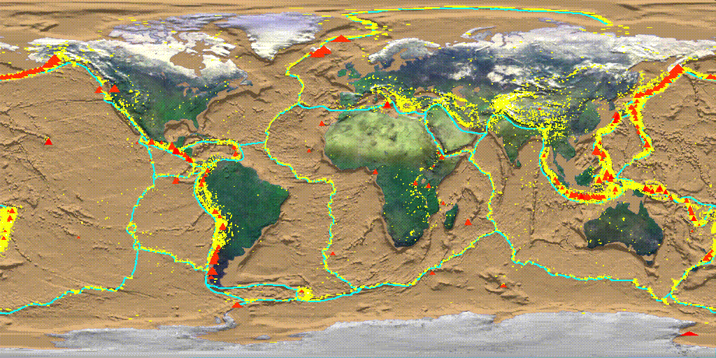
Figure \(\PageIndex{1}\) is a world map showing the global distribution of volcanic activity in relation to tectonic plate boundaries.
The continents and oceans are displayed on a world map. Thin colored lines outline the boundaries of Earth's tectonic plates, while red zones and clusters mark areas of active volcanism.
Major patterns
- Volcanic activity is concentrated along the edges of tectonic plates rather than being evenly distributed across Earth's surface.
- The most extensive concentration forms a nearly continuous belt around the Pacific Ocean, often called the Ring of Fire.
- This volcanic belt extends along the western coasts of North and South America, through Alaska and the Aleutian Islands, and across Japan, the Philippines, Indonesia, and New Zealand.
Mid-ocean ridges
- Additional volcanic activity follows long underwater mountain chains in the Atlantic, Indian, and Pacific Oceans.
- These volcanic belts coincide with mid-ocean ridges, where tectonic plates move apart and magma rises to create new oceanic crust.
Continental volcanic regions
- Volcanic activity is also present in portions of East Africa, the Mediterranean region, Iceland, and parts of Southeast Asia.
- Some volcanic regions occur within plate interiors rather than directly on boundaries, reflecting the influence of hot spots such as Hawaii.
Relationship to plate boundaries
- The close correspondence between volcanic zones and plate boundaries demonstrates that volcanism is strongly linked to plate tectonic processes.
- Convergent boundaries are associated with subduction-zone volcanoes, while divergent boundaries are associated with ridge volcanism
Subduction zone volcanoes and hot spot volcanoes differ primarily in their tectonic origins and the chemical nature of their magma. Subduction zone volcanoes form at convergent plate boundaries where an oceanic plate slides beneath another plate. As the descending slab reaches higher temperatures and pressures, water trapped in the crust is released, which lowers the melting point of the mantle above it. This process, known as flux melting, creates viscous, silica-rich magma that often leads to highly explosive eruptions and the formation of steep stratovolcanoes.
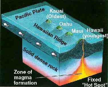
Figure \(\PageIndex{2}\) illustrates how the Hawaiian Island chain formed as the Pacific Plate moved over a stationary mantle hot spot. A cross-sectional view shows the Pacific Plate moving toward the northwest, indicated by an arrow. Beneath the plate is a fixed column of rising magma labeled fixed hot spot. This hot spot remains in the same location while the tectonic plate moves above it. Directly above the hot spot is the youngest island, Hawaii, shown as an active volcanic island where magma rises through the crust and erupts at the surface. A volcanic pathway extends upward from the hot spot to the island. Moving northwest away from the active volcano are the older islands of the Hawaiian chain, labeled Maui, Oahu, and Kauai. These islands are progressively farther from the hot spot and no longer receive a direct supply of magma. As a result, volcanic activity has ceased on the older islands. A label identifies the Hawaiian Ridge, the submerged extension of older volcanic islands and seamounts that continue northwest beyond the currently exposed islands. Beneath the Pacific Plate is a region labeled zone of magma generation, indicating where mantle material melts and supplies magma to the hot spot.
In contrast, hot spot volcanoes (Figure \(\PageIndex{2}\)) are usually located in the middle of tectonic plates rather than at the boundaries. They are fueled by mantle plumes, which are stationary columns of intense heat rising from deep within the Earth. The magma produced at hot spots is typically basaltic, meaning it is less viscous and flows more easily than magma found at subduction zones. This results in broad, gently sloping shield volcanoes and relatively effusive, non-explosive eruptions. While subduction zone volcanoes are part of a volcanic arc that remains stationary relative to the boundary, hot spot volcanoes often form a chronological chain as the tectonic plate moves over the fixed heat source.
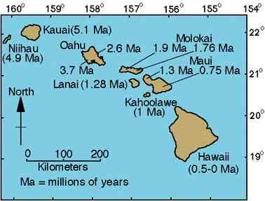
Figure \(\PageIndex{3}\) illustrates the age progression of the Hawaiian archipelago. The island chain extends from northwest to southeast across the Pacific Ocean, with each major island labeled by its approximate age in millions of years. The oldest islands, including Kauai and Niihau at the northwestern end of the chain, are approximately 5 million years old. Moving southeast, the islands become progressively younger: Oahu is about 2 to 4 million years old, Molokai is about 1 to 2 million years old, and Maui is less than 1 million years old. At the southeastern end of the chain, the Island of Hawaii is the youngest, with active volcanoes that are less than 0.5 million years old. An arrow indicates the northwestward movement of the Pacific Plate, illustrating how the islands increase in age with distance from the stationary mantle hot spot that currently lies beneath the Island of Hawaii.
Figure \(\PageIndex{4}\) is a photograph depicting a high-volume lava fountain erupting from the Pu`u `O`o cinder and spatter cone, which is located on the eastern rift zone of the Kilauea Volcano in Hawaii. The image captures a dramatic vertical spray of incandescent, orange-red molten basaltic lava being ejected into the air from a central vent. In the foreground, the dark, cooled, and hardened surfaces of previous lava flows provide a sharp color contrast to the glowing eruption. This specific feature is characteristic of Hawaiian-style eruptions, where relatively fluid, low-viscosity magma allows gas to escape, creating sustained fountains rather than a single explosive blast.

Rather than forming a mountain like the volcanoes in the Hawaiian Islands, some places have been covered by massive flows of basaltic lava due to volcanic activity. One of the best-known sites in North America is the Columbia Plateau. The Columbia Plateau is located in eastern Washington, south through eastern Oregon and most of southern Idaho.