

7.2: Plate Boundaries
- Page ID
- 42675

\( \newcommand{\vecs}[1]{\overset { \scriptstyle \rightharpoonup} {\mathbf{#1}} } \)
\( \newcommand{\vecd}[1]{\overset{-\!-\!\rightharpoonup}{\vphantom{a}\smash {#1}}} \)
\( \newcommand{\dsum}{\displaystyle\sum\limits} \)
\( \newcommand{\dint}{\displaystyle\int\limits} \)
\( \newcommand{\dlim}{\displaystyle\lim\limits} \)
\( \newcommand{\id}{\mathrm{id}}\) \( \newcommand{\Span}{\mathrm{span}}\)
( \newcommand{\kernel}{\mathrm{null}\,}\) \( \newcommand{\range}{\mathrm{range}\,}\)
\( \newcommand{\RealPart}{\mathrm{Re}}\) \( \newcommand{\ImaginaryPart}{\mathrm{Im}}\)
\( \newcommand{\Argument}{\mathrm{Arg}}\) \( \newcommand{\norm}[1]{\| #1 \|}\)
\( \newcommand{\inner}[2]{\langle #1, #2 \rangle}\)
\( \newcommand{\Span}{\mathrm{span}}\)
\( \newcommand{\id}{\mathrm{id}}\)
\( \newcommand{\Span}{\mathrm{span}}\)
\( \newcommand{\kernel}{\mathrm{null}\,}\)
\( \newcommand{\range}{\mathrm{range}\,}\)
\( \newcommand{\RealPart}{\mathrm{Re}}\)
\( \newcommand{\ImaginaryPart}{\mathrm{Im}}\)
\( \newcommand{\Argument}{\mathrm{Arg}}\)
\( \newcommand{\norm}[1]{\| #1 \|}\)
\( \newcommand{\inner}[2]{\langle #1, #2 \rangle}\)
\( \newcommand{\Span}{\mathrm{span}}\) \( \newcommand{\AA}{\unicode[.8,0]{x212B}}\)
\( \newcommand{\vectorA}[1]{\vec{#1}} % arrow\)
\( \newcommand{\vectorAt}[1]{\vec{\text{#1}}} % arrow\)
\( \newcommand{\vectorB}[1]{\overset { \scriptstyle \rightharpoonup} {\mathbf{#1}} } \)
\( \newcommand{\vectorC}[1]{\textbf{#1}} \)
\( \newcommand{\vectorD}[1]{\overrightarrow{#1}} \)
\( \newcommand{\vectorDt}[1]{\overrightarrow{\text{#1}}} \)
\( \newcommand{\vectE}[1]{\overset{-\!-\!\rightharpoonup}{\vphantom{a}\smash{\mathbf {#1}}}} \)
\( \newcommand{\vecs}[1]{\overset { \scriptstyle \rightharpoonup} {\mathbf{#1}} } \)
\(\newcommand{\longvect}{\overrightarrow}\)
\( \newcommand{\vecd}[1]{\overset{-\!-\!\rightharpoonup}{\vphantom{a}\smash {#1}}} \)
\(\newcommand{\ket}[1]{\left| #1 \right>}\)
\(\newcommand{\bra}[1]{\left< #1 \right|}\)
\(\newcommand{\braket}[2]{\left< #1 \vphantom{#2} \right| \left. #2 \vphantom{#1} \right>}\)
\(\newcommand{\braopket}[3]{\left< #1 \vphantom{#2}\vphantom{#3} \right| #2 \vphantom{#1}\vphantom{#3} \left| #3 \vphantom{#1}\vphantom{#2} \right>}\)
\(\newcommand{\qmvec}[1]{\mathbf{\vec{#1}}}\)
\(\newcommand{\op}[1]{\hat{\mathbf{#1}}}\)
\(\newcommand{\expect}[1]{\langle #1 \rangle}\)
\(\newcommand{\dfn}[1]{\emph{\textbf{#1}}}\)
Interactions at Plate Boundaries
Along the boundary of the Earth's tectonic plates a fiery drama of catastrophic proportions is played out. Movement of the Earth's crust creates earthquake activity and in some places great outpourings of lava extrude onto the surface. Figure \(\PageIndex{1}\) shows the 15 major tectonic plates into which the Earth's crust is divided and Figure \(\PageIndex{2}\) illustrates the different types of plate boundaries.
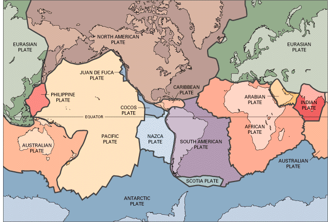
Figure \(\PageIndex{1}\) is a world map showing the major tectonic plates of Earth and the boundaries between them.
The map is divided into large, differently shaded regions, each representing a tectonic plate. Thick dark lines mark the boundaries where plates meet. The major plates are labeled, including:
- Pacific Plate
- North American Plate
- South American Plate
- Eurasian Plate
- African Plate
- Australian Plate
- Antarctic Plate
Several smaller plates are also identified, including the:
- Nazca Plate
- Cocos Plate
- Caribbean Plate
- Juan de Fuca Plate
- Philippine Plate
- Arabian Plate
- Indian Plate
- Scotia Plate
The Pacific Plate occupies a large portion of the Pacific Ocean and is bordered by several smaller plates along its margins. The Nazca Plate lies west of South America, the Cocos Plate west of Central America, and the Juan de Fuca Plate off the northwestern coast of North America. The Indian Plate is shown south of Asia, and the Arabian Plate lies between Africa and Eurasia.
The plate boundaries form a connected global network that crosses both oceans and continents, outlining the locations where plates interact.
The map illustrates that Earth's lithosphere is divided into multiple rigid tectonic plates rather than a single continuous shell. These plates move slowly relative to one another, and their interactions at plate boundaries generate many of Earth's major geologic processes, including earthquakes, volcanoes, mountain building, seafloor spreading, and subduction. The figure provides a global framework for understanding plate tectonics and the distribution of geologic activity around the world.
This USGS map in Figure \(\PageIndex{1}\), illustrates the mosaic of tectonic plates that comprise the Earth's outer shell, or lithosphere. Rather than being a solid, continuous layer, the crust is broken into several large and small fragments that fit together like pieces of a giant spherical puzzle. Figure \(\PageIndex{1}\) highlights the boundaries of the major tectonic plates, including the Pacific, North American, Eurasian, African, Indo-Australian, South American, and Antarctic plates. Each boundary is a site of significant geological activity, as these massive slabs of rock are in constant, slow motion—typically moving only a few centimeters per year.

Figure \(\PageIndex{2}\) illustrates the Ring of Fire as a massive, horseshoe-shaped zone tracing the edge of the Pacific Ocean. This region is defined by a nearly continuous series of convergent plate boundaries, marked on the map with red lines and teeth indicating where one plate is being forced beneath another. These subduction zones are responsible for the high concentration of volcanic arcs shown, such as the Aleutian, Japanese, and Cascade arcs. The dense clustering of yellow dots along these specific lines highlights that the majority of the Earth's seismic activity and volcanic eruptions are not random, but are directly tied to these active tectonic margins
This concentration of activity occurs because the Pacific Plate and other smaller oceanic plates, like the Nazca and Cocos plates, are constantly colliding with and sliding under the surrounding continental plates. As the subducting oceanic crust is forced into the mantle, it melts and rises to the surface as magma, creating the volcanic mountain ranges and island chains seen throughout the region. The map visually confirms that the Ring of Fire is a primary site for the recycling of the Earth's crust, where the movement of rigid lithospheric slabs continuously deforms the landscape and triggers potentially catastrophic geological events.

Figure \(\PageIndex{3}\) is a cross-sectional illustration showing several types of tectonic plate boundaries and related geologic features above and below Earth's surface.
Earth's layers - The lower portion of the diagram shows two major layers:
- A rigid upper layer labeled lithosphere.
- A softer, flowing layer beneath labeled asthenosphere.
Arrows within and along the lithosphere indicate the direction of plate movement.
Left side: Oceanic–oceanic convergent boundary. At the far left, one oceanic plate is subducting beneath another oceanic plate. Features shown include:
- A deep ocean trench at the plate boundary.
- A chain of volcanic islands labeled island arc.
- A stratovolcano formed by rising magma above the subducting plate.
This section demonstrates how subduction between two oceanic plates creates trenches and volcanic island chains.
Transform plate boundary - Moving right, a labeled transform plate boundary offsets segments of oceanic crust. The plates slide horizontally past one another rather than colliding or separating. This type of boundary is associated with fault movement and earthquakes but does not create or destroy crust.
Hot spot and shield volcano
Near the middle-left of the diagram, a vertical plume of magma rises from beneath the lithosphere.
This feature is labeled hot spot and produces a broad shield volcano at the surface.
The volcano forms independently of plate boundaries as a tectonic plate moves over a stationary source of magma.
Divergent plate boundary - At the center of the figure is a divergent plate boundary. Features include:
- An oceanic spreading ridge or mid-ocean ridge.
- Upwelling magma rising from the asthenosphere.
- Arrows showing plates moving apart in opposite directions.
This area represents seafloor spreading, where new oceanic crust is created.
Oceanic–continental convergent boundary: To the right of the spreading ridge is another convergent plate boundary. In this section:
- Dense oceanic crust descends beneath lighter continental crust.
- A deep trench forms offshore.
- The descending slab is labeled subducting plate.
- Magma generated above the subducting plate rises through the continent to feed a volcano.
This illustrates how continental volcanic mountain chains form along subduction zones.
Continental rift zone - At the far right is a continental rift zone (young plate boundary). The continental crust is being pulled apart, creating:
- A long linear rift valley.
- Normal faulting and crustal thinning.
- Upwelling magma beneath the stretching crust.
Arrows show the continents moving away from each other, indicating the early stages of a new divergent plate boundary.
Geologists recognize three primary types of plate tectonic boundaries, as depicted in Figure \(\PageIndex{2}\) and Figure \(\PageIndex{3}\). The first section shows a divergent boundary, also known as a spreading boundary, which occurs where two oceanic plates move away or diverge from one another. This process is common along the midocean ridge, where upwelling magma from the mantle rises to the surface and solidifies to create new oceanic crust.
The second section of Figure \(\PageIndex{3}\) and the details in Figure \(\PageIndex{4}\) depict a convergent boundary. This setting is located where two plates collide and subduction is active. In this scenario, as shown on the left side of the diagram, an oceanic plate is forced beneath a continental plate. Because the oceanic crust is denser, it is pushed down into a deep ocean trench where the lithosphere is consumed. As this subducted material melts and rises, it leads to the formation of a volcanic arc or a chain of volcanoes on the land surface above. Powerful earthquakes are frequently associated with these boundaries.
The third section represents a transform boundary, which occurs where two plates slide or grind past one another horizontally along a linear fault line. As illustrated on the right side of the diagram, this movement occurs along a vertical fault, such as the San Andreas Fault. While crust is cracked and broken at these margins, it is neither created nor destroyed. Arrows throughout these figures indicate the specific direction of movement for each plate, providing a spatial context for how these systems coexist. Additionally, some regions are classified as plate boundary zones, which are broad belts where boundaries are not well defined and the specific effects of plate interaction remain unclear.
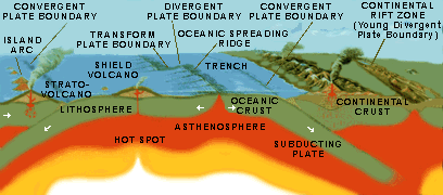
Plate Boundaries and Earthquakes
An earthquake is the shaking of the Earth as a result of crustal movement. Earthquakes emanate from faults, or fractures in the Earth, where movement occurs. Most earthquakes occur at the boundaries where plates meet. Submarine earthquakes create seismic ocean waves that travel long distances across the ocean. They often strike land with devastating consequences. The location of earthquakes and the ruptures associated with them are what scientists use to define plate edges.
There are several different kinds of faults classified according to the type of movement that occurs. Where plates move horizontally past one another, transform faults occur. Such is the case of the San Andreas Fault in California (shown in Figure \(\PageIndex{5}\)). Where the crust is spreading apart, like the mid-ocean ridge, shallow earthquakes (within 30 kilometers of the surface) are common. Shallow to deep earthquakes occur along subduction zones where one plate overrides another, like that which occurs along the northwest coast of the United States, western Canada and southern Alaska.
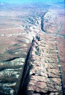
Plate Boundaries and Volcanoes
Looking at a map of lithospheric plate boundaries shows volcanic activity along the boundaries of some lithospheric plates. Convergent plate boundaries where subduction occurs commonly experience volcanic activity. The "Ring of Fire" that extends from the west coast of the United States toward the Aleutian Islands and over to Japan is a good example of volcano activity associated with the margins of plates. Mt. St. Helens (Washington), Mt. Shishaldin (Alaska) (shown in Figure \(\PageIndex{6}\)), and Mt. Fujiyama (Japan) were born from the collision and associated melting of plates beneath the surface of the Earth. These "stratovolcanoes" are built by enormous eruptions of viscous lava and ash created from magma rich in silica.

Volcanoes are also found along spreading plate boundaries. Here, basaltic magma is extruded onto the floor of the ocean. In some places, the magma solidifies into great volcanic cones rising from the ocean floor. Iceland's Heimaey volcano is a good example of volcanic activity along the mid-ocean ridge.
One of the most well-known locations for volcanic activity, the Hawaiian Islands, is not a product of plate margin processes. The Hawaiian Islands have formed over a "hot spot" or mantle plume where magma rises to the surface and flows out onto the ocean floor. The chain of islands were created as the Pacific Plate moves over the mantle plume creating a succession of volcanoes oriented in a northwest (oldest) to southeast direction (youngest).