

6.3: Orders of Relief
- Page ID
- 42665

\( \newcommand{\vecs}[1]{\overset { \scriptstyle \rightharpoonup} {\mathbf{#1}} } \)
\( \newcommand{\vecd}[1]{\overset{-\!-\!\rightharpoonup}{\vphantom{a}\smash {#1}}} \)
\( \newcommand{\dsum}{\displaystyle\sum\limits} \)
\( \newcommand{\dint}{\displaystyle\int\limits} \)
\( \newcommand{\dlim}{\displaystyle\lim\limits} \)
\( \newcommand{\id}{\mathrm{id}}\) \( \newcommand{\Span}{\mathrm{span}}\)
( \newcommand{\kernel}{\mathrm{null}\,}\) \( \newcommand{\range}{\mathrm{range}\,}\)
\( \newcommand{\RealPart}{\mathrm{Re}}\) \( \newcommand{\ImaginaryPart}{\mathrm{Im}}\)
\( \newcommand{\Argument}{\mathrm{Arg}}\) \( \newcommand{\norm}[1]{\| #1 \|}\)
\( \newcommand{\inner}[2]{\langle #1, #2 \rangle}\)
\( \newcommand{\Span}{\mathrm{span}}\)
\( \newcommand{\id}{\mathrm{id}}\)
\( \newcommand{\Span}{\mathrm{span}}\)
\( \newcommand{\kernel}{\mathrm{null}\,}\)
\( \newcommand{\range}{\mathrm{range}\,}\)
\( \newcommand{\RealPart}{\mathrm{Re}}\)
\( \newcommand{\ImaginaryPart}{\mathrm{Im}}\)
\( \newcommand{\Argument}{\mathrm{Arg}}\)
\( \newcommand{\norm}[1]{\| #1 \|}\)
\( \newcommand{\inner}[2]{\langle #1, #2 \rangle}\)
\( \newcommand{\Span}{\mathrm{span}}\) \( \newcommand{\AA}{\unicode[.8,0]{x212B}}\)
\( \newcommand{\vectorA}[1]{\vec{#1}} % arrow\)
\( \newcommand{\vectorAt}[1]{\vec{\text{#1}}} % arrow\)
\( \newcommand{\vectorB}[1]{\overset { \scriptstyle \rightharpoonup} {\mathbf{#1}} } \)
\( \newcommand{\vectorC}[1]{\textbf{#1}} \)
\( \newcommand{\vectorD}[1]{\overrightarrow{#1}} \)
\( \newcommand{\vectorDt}[1]{\overrightarrow{\text{#1}}} \)
\( \newcommand{\vectE}[1]{\overset{-\!-\!\rightharpoonup}{\vphantom{a}\smash{\mathbf {#1}}}} \)
\( \newcommand{\vecs}[1]{\overset { \scriptstyle \rightharpoonup} {\mathbf{#1}} } \)
\(\newcommand{\longvect}{\overrightarrow}\)
\( \newcommand{\vecd}[1]{\overset{-\!-\!\rightharpoonup}{\vphantom{a}\smash {#1}}} \)
\(\newcommand{\ket}[1]{\left| #1 \right>}\)
\(\newcommand{\bra}[1]{\left< #1 \right|}\)
\(\newcommand{\braket}[2]{\left< #1 \vphantom{#2} \right| \left. #2 \vphantom{#1} \right>}\)
\(\newcommand{\braopket}[3]{\left< #1 \vphantom{#2}\vphantom{#3} \right| #2 \vphantom{#1}\vphantom{#3} \left| #3 \vphantom{#1}\vphantom{#2} \right>}\)
\(\newcommand{\qmvec}[1]{\mathbf{\vec{#1}}}\)
\(\newcommand{\op}[1]{\hat{\mathbf{#1}}}\)
\(\newcommand{\expect}[1]{\langle #1 \rangle}\)
\(\newcommand{\dfn}[1]{\emph{\textbf{#1}}}\)
First Order Relief Features
The topography of the Earth is a product of endogenic and exogenic processes. Relief is simply the difference in elevation between two points. When the surface is relatively flat we say it has low relief. Conversely, mountainous regions have high relief. The relief features of the earth are be divided into three orders based on what created them and their size.
First order relief features are the tectonic plates and are the largest in spatial extent. Two types of plates, continental and oceanic are differentiated by their rock and mineral composition. Continental plates are lighter in density and composed mostly of granitic rock material rich in silica and aluminum. The oceanic plates are made of dense, basaltic rock composed predominately of silica and magnesium.
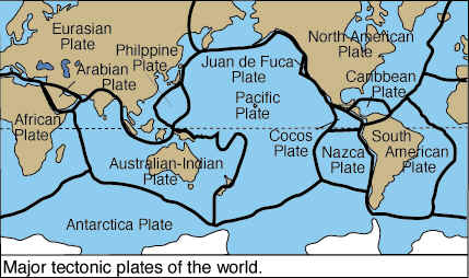
Figure \(\PageIndex{1}\) is a world map showing the major tectonic plates of Earth and their boundaries. The continents are displayed on a global map, with thick dark lines marking the boundaries between tectonic plates. Each plate is labeled with its name.
Major plates shown include:
- North American Plate
- South American Plate
- Eurasian Plate
- African Plate
- Antarctic Plate
- Australian–Indian Plate
- Pacific Plate
Several smaller plates are also labeled, including:
- Nazca Plate
- Cocos Plate
- Caribbean Plate
- Juan de Fuca Plate
- Arabian Plate
- Philippine Plate
The Pacific Plate occupies much of the Pacific Ocean and is surrounded by several smaller plates and plate boundaries. The Nazca Plate lies west of South America, while the Cocos Plate lies west of Central America. The Juan de Fuca Plate is located off the northwestern coast of North America. The Australian–Indian Plate includes Australia and parts of the Indian Ocean.
The plate boundaries form a connected global network, crossing ocean basins and cutting through some continental regions. These boundaries mark locations where tectonic plates interact by moving apart, colliding, or sliding past one another.
The map illustrates that Earth's outer lithosphere is divided into several large and smaller tectonic plates rather than being a single continuous shell. The plate boundaries shown on the map are the primary locations of earthquakes, volcanoes, mountain building, seafloor spreading, and subduction. The figure provides a framework for understanding global plate tectonics and the distribution of geologic activity across Earth.
Second Order Relief Features
Second order relief features are the result of plate collision or divergence. Rifts form where plates diverge from one another. If parallel rifting occurs, rift valleys, like the Great Rift Valley of Africa can form. Rifting can be accompanied by volcanic activity as magma pours out of the rift. Mt. Kilimanjaro was formed as a result of the rifting that created the Great Rift Valley of Africa.
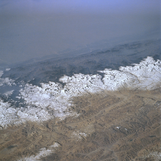
Great mountain systems or trenches are created when plates converge. When two continental plates collide it causes the Earth to fold and buckle. Such is the case when the Indian Plate collided with the Eurasian Plate creating the Himalaya Mountains. Marine fossils are found at high altitudes where they were pushed up as a result of the collision. The presence of fossil marine organisms on high mountain peaks was used as evidence to support the theory of plate tectonics. Today, the uplift continues as the Indian Plate forces its way northward against the Eurasian, increasing the height of the world's tallest peaks.
Extending from the northwest coast of the United States up along the Pacific Coast of Canada is the site where the Juan de la Fuca plate, an oceanic plate, is colliding with the North American plate, a continental plate. The denser and heavier oceanic plate dives beneath the lighter, less dense continental plate in a process of subduction. Subduction zones are noted for their frequent earthquake and volcanic activity. As the oceanic plate dives towards the interior of the earth the rock melts and some makes its way to the surface exploding with great fury to create spectacular volcanic cones.
Third Order Relief Features
Third order relief features are for the most part created by erosion and deposition of the surface as opposed to the movement of tectonic plates. Individual landforms are considered third order relief features. There is no upper or lower limit to the size of third order relief features. One way to distinguish between second and third order relief features is one can see the entire form of third order feature but not a second.

Pawnee cirque, the bowl shaped feature in the center of Figure \(\PageIndex{3}\) was caused by an alpine glacier eroding into the side of a mountain. The bowl-shaped depression left behind represents a third order relief feature of the earth. The picture was shot from across Isabelle Valley on Niwot Ridge. It is easy to see the full extent of the cirque but not the second order relief feature that it is located in, the Rocky Mountain system.
The surface features studied by physical geographers are not only dependent on the various forces that create them, but the material composition of the Earth as well. The mineral content of rock, and the type of rock greatly effect their resistance to geological agents of erosion and hence the surface features of our planet. To understand the geographical variation of Earth surface features, we need a fundamental knowledge of the materials that comprise the Earth and their mode of origin.