

5.9.6: Marine (Humid) West Coast Climate
- Page ID
- 42654

\( \newcommand{\vecs}[1]{\overset { \scriptstyle \rightharpoonup} {\mathbf{#1}} } \)
\( \newcommand{\vecd}[1]{\overset{-\!-\!\rightharpoonup}{\vphantom{a}\smash {#1}}} \)
\( \newcommand{\dsum}{\displaystyle\sum\limits} \)
\( \newcommand{\dint}{\displaystyle\int\limits} \)
\( \newcommand{\dlim}{\displaystyle\lim\limits} \)
\( \newcommand{\id}{\mathrm{id}}\) \( \newcommand{\Span}{\mathrm{span}}\)
( \newcommand{\kernel}{\mathrm{null}\,}\) \( \newcommand{\range}{\mathrm{range}\,}\)
\( \newcommand{\RealPart}{\mathrm{Re}}\) \( \newcommand{\ImaginaryPart}{\mathrm{Im}}\)
\( \newcommand{\Argument}{\mathrm{Arg}}\) \( \newcommand{\norm}[1]{\| #1 \|}\)
\( \newcommand{\inner}[2]{\langle #1, #2 \rangle}\)
\( \newcommand{\Span}{\mathrm{span}}\)
\( \newcommand{\id}{\mathrm{id}}\)
\( \newcommand{\Span}{\mathrm{span}}\)
\( \newcommand{\kernel}{\mathrm{null}\,}\)
\( \newcommand{\range}{\mathrm{range}\,}\)
\( \newcommand{\RealPart}{\mathrm{Re}}\)
\( \newcommand{\ImaginaryPart}{\mathrm{Im}}\)
\( \newcommand{\Argument}{\mathrm{Arg}}\)
\( \newcommand{\norm}[1]{\| #1 \|}\)
\( \newcommand{\inner}[2]{\langle #1, #2 \rangle}\)
\( \newcommand{\Span}{\mathrm{span}}\) \( \newcommand{\AA}{\unicode[.8,0]{x212B}}\)
\( \newcommand{\vectorA}[1]{\vec{#1}} % arrow\)
\( \newcommand{\vectorAt}[1]{\vec{\text{#1}}} % arrow\)
\( \newcommand{\vectorB}[1]{\overset { \scriptstyle \rightharpoonup} {\mathbf{#1}} } \)
\( \newcommand{\vectorC}[1]{\textbf{#1}} \)
\( \newcommand{\vectorD}[1]{\overrightarrow{#1}} \)
\( \newcommand{\vectorDt}[1]{\overrightarrow{\text{#1}}} \)
\( \newcommand{\vectE}[1]{\overset{-\!-\!\rightharpoonup}{\vphantom{a}\smash{\mathbf {#1}}}} \)
\( \newcommand{\vecs}[1]{\overset { \scriptstyle \rightharpoonup} {\mathbf{#1}} } \)
\(\newcommand{\longvect}{\overrightarrow}\)
\( \newcommand{\vecd}[1]{\overset{-\!-\!\rightharpoonup}{\vphantom{a}\smash {#1}}} \)
\(\newcommand{\ket}[1]{\left| #1 \right>}\)
\(\newcommand{\bra}[1]{\left< #1 \right|}\)
\(\newcommand{\braket}[2]{\left< #1 \vphantom{#2} \right| \left. #2 \vphantom{#1} \right>}\)
\(\newcommand{\braopket}[3]{\left< #1 \vphantom{#2}\vphantom{#3} \right| #2 \vphantom{#1}\vphantom{#3} \left| #3 \vphantom{#1}\vphantom{#2} \right>}\)
\(\newcommand{\qmvec}[1]{\mathbf{\vec{#1}}}\)
\(\newcommand{\op}[1]{\hat{\mathbf{#1}}}\)
\(\newcommand{\expect}[1]{\langle #1 \rangle}\)
\(\newcommand{\dfn}[1]{\emph{\textbf{#1}}}\)
Geographical Distribution

The marine or humid west coast climate is exactly what its name describes. This climate is found on the west coast of midlatitude continents and is very humid through most of the year. Its geographic location places it in the path of westerly winds from the ocean that bring cloudy skies, much precipitation, and mild temperatures. The distribution of the climate is greatly influenced by the orientation of mountain systems in North America and Europe.
The marine west coast climate is found along a relatively narrow strip of coastal Oregon, Washington, British Columbia, and southern Alaska in North America. It is likewise found along coastal Chile in South America. The marine west coast climate extends further inland into northwest Europe than in North America due to the orientation of mountains. This climate is also found on the southeast coast of Australia and New Zealand.
Controlling Factors
The most important control over the climate characteristics of the marine west coast is its west coast location in the midlatitudes. Here maritime polar air masses are constantly coming ashore bringing mild temperatures and high humidity. In some cases like northern Europe, warm ocean currents moderate the temperature of the site.
As noted above, the orientation of mountains has a large effect on the geographic distribution of the climate. In North and South America, mountains tend to be north-south oriented, whereas in Europe they tend to run more west to east. The north-south orientation acts as barrier to oceanic air masses in the Westerlies forcing them to rise and cool producing cloudy, rainy conditions along the coast. In Europe, the oceanic air masses can penetrate further inland, moderating the climate of a much larger region.
A significant difference in the climate situations at Vancouver (Figure \(\PageIndex{2}\)) and London (Figure \(\PageIndex{3}\)), both Marine West Coast climates, arises from location, local topography, and ocean current influence. The dry summer in Vancouver is due in part to subsiding, subtropical high pressure lying to the south. Precipitation is nearly double that of London due to local orographic uplift of air. Milder winter temperatures in London arise from the moderating influence of the North Atlantic Drift.
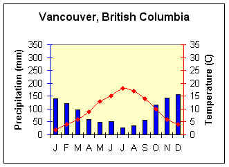
Figure \(\PageIndex{2}\) is a climate graph for Vancouver, British Columbia. The horizontal axis shows the months January through December. The left vertical axis is labeled “Precipitation (mm)” and ranges from 0 to 350 millimeters. The right vertical axis is labeled “Temperature (°C)” and ranges from 0°C to 35°C. Precipitation is represented by blue bars. Rainfall is highest during the autumn and winter months, especially from October through January, when monthly totals exceed 100 millimeters. Precipitation decreases during spring and reaches its lowest levels in July and August, before increasing again in autumn. Temperature is represented by a red line with diamond markers. Temperatures are mild year-round, rising from about 4°C in January to approximately 19°C in July and August, then gradually declining through autumn and winter. The main conclusions from the climograph are:
Latitude/Longitude = 49.1oN; 123.06oW
Average Annual Temperature (oC) = 9.8
Annual Temperature Range (oC) =16
Total Annual Precipitation (mm) =1048
Summer Precipitation (mm) = 277
Winter Precipitation (mm) = 771

Figure \(\PageIndex{3}\) is a climate graph for London, England.
The horizontal axis shows the months January through December. The left vertical axis is labeled “Precipitation (mm)” and ranges from 0 to 350 millimeters. The right vertical axis is labeled “Temperature (°C)” and ranges from 0°C to 35°C.
Precipitation is represented by blue bars. Rainfall occurs throughout the year with relatively little seasonal variation. Monthly precipitation generally ranges from about 40 to 80 millimeters, with slightly higher amounts in late summer and autumn.
Temperature is represented by a red line with diamond markers. Temperatures are mild year-round, increasing from about 5°C in January to approximately 18°C in July, then gradually declining through autumn and winter. The main conclusions from the climograph are:
Latitude/Longitude =51.3oN; .07oW
Average Annual Temperature (oC) = 10.4
Annual Temperature Range (oC) = 14
Total Annual Precipitation (mm) = 595
Summer Precipitation (mm) = 295
Winter Precipitation (mm) =300
Distinguishing Characteristics
Temperature
The marine west coast is noted for its mild summers and winters and, as a result, a small annual temperature range. Its location on the west coast of a continent in the midlatitudes places the climate in the path of the Westerlies. In this situation, the climate receives a constant influx of oceanic air throughout the year. The mild temperatures are a direct result of the moderating influence of ocean bodies on air temperatures. The is especially true for those situations where a warm ocean current borders the continent, like the North Atlantic Drift's effect on northwestern Europe. Temperature ranges increase as one moves away from the coast.
Precipitation
Not only is the marine west coast noted for its mild temperatures but also for its heavy cloud cover and high humidity through much of the year. This is especially true for the marine west coast climate of North America where orographic uplift is an important climate control. Maritime polar air masses forced to rise up the windward, western slope create significant cloud cover and precipitation. The marine west coast climate is dominated by cyclonic activity embedded in the Westerlies. Frequent cyclonic storms bring prolonged periods of rain, drizzle and fog to these west coast locations. In some locations it is not uncommon to receive as much as 2540 mm (100 in) of precipitation in a year, an amount that rivals the rainy tropics.