

5.9.5: Humid Continental Climate
- Page ID
- 42653

\( \newcommand{\vecs}[1]{\overset { \scriptstyle \rightharpoonup} {\mathbf{#1}} } \)
\( \newcommand{\vecd}[1]{\overset{-\!-\!\rightharpoonup}{\vphantom{a}\smash {#1}}} \)
\( \newcommand{\dsum}{\displaystyle\sum\limits} \)
\( \newcommand{\dint}{\displaystyle\int\limits} \)
\( \newcommand{\dlim}{\displaystyle\lim\limits} \)
\( \newcommand{\id}{\mathrm{id}}\) \( \newcommand{\Span}{\mathrm{span}}\)
( \newcommand{\kernel}{\mathrm{null}\,}\) \( \newcommand{\range}{\mathrm{range}\,}\)
\( \newcommand{\RealPart}{\mathrm{Re}}\) \( \newcommand{\ImaginaryPart}{\mathrm{Im}}\)
\( \newcommand{\Argument}{\mathrm{Arg}}\) \( \newcommand{\norm}[1]{\| #1 \|}\)
\( \newcommand{\inner}[2]{\langle #1, #2 \rangle}\)
\( \newcommand{\Span}{\mathrm{span}}\)
\( \newcommand{\id}{\mathrm{id}}\)
\( \newcommand{\Span}{\mathrm{span}}\)
\( \newcommand{\kernel}{\mathrm{null}\,}\)
\( \newcommand{\range}{\mathrm{range}\,}\)
\( \newcommand{\RealPart}{\mathrm{Re}}\)
\( \newcommand{\ImaginaryPart}{\mathrm{Im}}\)
\( \newcommand{\Argument}{\mathrm{Arg}}\)
\( \newcommand{\norm}[1]{\| #1 \|}\)
\( \newcommand{\inner}[2]{\langle #1, #2 \rangle}\)
\( \newcommand{\Span}{\mathrm{span}}\) \( \newcommand{\AA}{\unicode[.8,0]{x212B}}\)
\( \newcommand{\vectorA}[1]{\vec{#1}} % arrow\)
\( \newcommand{\vectorAt}[1]{\vec{\text{#1}}} % arrow\)
\( \newcommand{\vectorB}[1]{\overset { \scriptstyle \rightharpoonup} {\mathbf{#1}} } \)
\( \newcommand{\vectorC}[1]{\textbf{#1}} \)
\( \newcommand{\vectorD}[1]{\overrightarrow{#1}} \)
\( \newcommand{\vectorDt}[1]{\overrightarrow{\text{#1}}} \)
\( \newcommand{\vectE}[1]{\overset{-\!-\!\rightharpoonup}{\vphantom{a}\smash{\mathbf {#1}}}} \)
\( \newcommand{\vecs}[1]{\overset { \scriptstyle \rightharpoonup} {\mathbf{#1}} } \)
\(\newcommand{\longvect}{\overrightarrow}\)
\( \newcommand{\vecd}[1]{\overset{-\!-\!\rightharpoonup}{\vphantom{a}\smash {#1}}} \)
\(\newcommand{\ket}[1]{\left| #1 \right>}\)
\(\newcommand{\bra}[1]{\left< #1 \right|}\)
\(\newcommand{\braket}[2]{\left< #1 \vphantom{#2} \right| \left. #2 \vphantom{#1} \right>}\)
\(\newcommand{\braopket}[3]{\left< #1 \vphantom{#2}\vphantom{#3} \right| #2 \vphantom{#1}\vphantom{#3} \left| #3 \vphantom{#1}\vphantom{#2} \right>}\)
\(\newcommand{\qmvec}[1]{\mathbf{\vec{#1}}}\)
\(\newcommand{\op}[1]{\hat{\mathbf{#1}}}\)
\(\newcommand{\expect}[1]{\langle #1 \rangle}\)
\(\newcommand{\dfn}[1]{\emph{\textbf{#1}}}\)
Controlling Factors
The humid continental climate is found over great expanses in the temperate regions of the mid-latitudes. The humid continental climate is noted for its variable weather patterns related to cyclonic storms and its large temperature range due to its interior location in mid-latitude continents.
The humid continental climate is known for its variable weather conditions due to its location in the midlatitudes and the year-round influence of the polar front. This climate lies in the boundary zone between many different air masses, principally polar and tropical ones. Polar-type air masses collide with tropical type air masses causing uplift of the less dense and moister tropical air resulting in precipitation. Colliding along the polar front, these air masses turn and swirl into large extratropical cyclones steered by the polar front jet stream lying high in the troposphere. These huge systems generally work their way across the surface in a west to east fashion, embedded in the dominate wind flow of the westerly wind belt.

Continentality is an important controlling factor over the characteristics of this climate. The humid continental climate is primarily located within the interior of most midlatitude continents. Being removed from the moderating influence of the oceans, the climate experiences great swings in seasonal temperature. Annual temperature ranges can exceed 40oC (82oF). Where the periphery of the climate borders the ocean, summer temperatures are slightly cooler and winter temperatures slightly warmer than the interior. During the winter, the polar high expands in area to influence the northern portion of the continental humid climate. Record-setting cold temperatures occur during winter when continental arctic air masses sweep into the region. Otherwise, continental polar air masses dominate for much of the winter.

Precipitation in the humid continental climate is primarily due to invasions of maritime tropical air. In North America, the Gulf of Mexico and the Caribbean Ocean serve as source regions for maritime tropical (mT) air masses. Much of the precipitation east of the Rocky Mountains is due to the humid nature of the mT air, whether this be during the summer or the winter. A noticeable decrease and seasonality to the precipitation occurs as distance from the source region increases.
Warm Summer Subtype
The warm summer subtype of the humid continental climate in North America lies on the eastern and midwestern portion of the United States from the Atlantic to the 100th Meridian. The climate is also found in east central Europe, northern China, and northern Korea. The warm summer subtype is noted for its hot, humid summers and occasional winter cold waves.
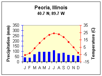
Figure \(\PageIndex{3}\) is a climate graph for Peoria, Illinois (40.7° N, 89.7° W).
The horizontal axis shows the months January through December. The left vertical axis is labeled “Precipitation (mm)” and ranges from 0 to 350 millimeters. The right vertical axis is labeled “Temperature (°C)” and ranges from approximately −15°C to 35°C.
Precipitation is represented by blue bars. Rainfall occurs throughout the year, generally ranging from about 50 to 120 millimeters per month. Precipitation is highest during the late spring and summer months, particularly from May through August, and somewhat lower during winter.
Temperature is represented by a red line with diamond markers. Temperatures are below freezing in January, rise steadily through spring, peak near 27°C in July, and then decline through autumn back to below freezing by December.
Peoria, Illinois lies in the warm summer subtype with an average annual temperature is 10.4oC (50.7oF). It has a rather large annual temperature range of 29.8oC, summer temperatures average 19.2oC (65.5oF), while winter temperatures are 1.6oC (35oF). Typical of the humid continental climate most of its precipitation falls during the summer when air masses are warmer and wetter.
Cool Summer Subtype
The cool summer subtype of the humid continental climate in North America is found in New England, throughout much of the Great Lakes region and upper Midwest extending into south and south central Canada. Much of Scandinavia, eastern Europe and Russia fall into the cool summer subtype as well.
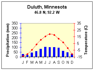
Figure \(\PageIndex{4}\) is a climate graph for Duluth, Minnesota (46.8° N, 92.2° W).
The horizontal axis shows the months January through December. The left vertical axis is labeled “Precipitation (mm)” and ranges from 0 to 350 millimeters. The right vertical axis is labeled “Temperature (°C)” and ranges from approximately −15°C to 35°C.
Precipitation is represented by blue bars. Precipitation occurs throughout the year, with lower amounts during winter and higher amounts during the warmer months. Rainfall peaks from June through September, reaching about 100 millimeters per month, before decreasing during autumn and winter.
Temperature is represented by a red line with diamond markers. Temperatures are very cold in winter, near −12°C in January, rise steadily through spring, peak around 20°C in July, and then decline through autumn back below freezing by December.
Duluth, Minnesota well represents the cool summer subtype of the humid continental climate. Like the warm summer subtype, most of its precipitation falls in the summer half of the year. However, it receives less precipitation due to the colder temperatures and their associated lower humidity.
There is a noticeable decrease in the temperature from that of the warm summer subtype too. Average annual temperature at Duluth is a cold 3.8oC (39oF). The cool summer subtype not only has cooler summertime temperatures, but very cold temperatures during the winter, with many months averaging below 0oC (32oF).
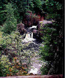
The humid continental climate supports a diversity of ecosystems, the type of which depends on their geographic location within the boundaries of the climate. Mixed broadleaf deciduous forest is common in the southern and eastern portions of the climate in the United States. Toward the west where the precipitation is less, forests give way to grasslands. The tall grass prairies of central Iowa and Illinois flourished in the climate long before white settlers inhabited the region.
The temperate climate and fertile soils found in the humid continental climate has created the most productive region for agriculture. The agricultural breadbasket of North America has historically been found in this climate. Settlers in North America cleared the large expanses of deciduous forest and plowed the fertile prairies. Corn, soy beans, are widely grown. In the colder, less suitable northern portions, dairy farming has been a long agricultural tradition.