

5.9.2: Midlatitude Desert Climate
- Page ID
- 42650

\( \newcommand{\vecs}[1]{\overset { \scriptstyle \rightharpoonup} {\mathbf{#1}} } \)
\( \newcommand{\vecd}[1]{\overset{-\!-\!\rightharpoonup}{\vphantom{a}\smash {#1}}} \)
\( \newcommand{\dsum}{\displaystyle\sum\limits} \)
\( \newcommand{\dint}{\displaystyle\int\limits} \)
\( \newcommand{\dlim}{\displaystyle\lim\limits} \)
\( \newcommand{\id}{\mathrm{id}}\) \( \newcommand{\Span}{\mathrm{span}}\)
( \newcommand{\kernel}{\mathrm{null}\,}\) \( \newcommand{\range}{\mathrm{range}\,}\)
\( \newcommand{\RealPart}{\mathrm{Re}}\) \( \newcommand{\ImaginaryPart}{\mathrm{Im}}\)
\( \newcommand{\Argument}{\mathrm{Arg}}\) \( \newcommand{\norm}[1]{\| #1 \|}\)
\( \newcommand{\inner}[2]{\langle #1, #2 \rangle}\)
\( \newcommand{\Span}{\mathrm{span}}\)
\( \newcommand{\id}{\mathrm{id}}\)
\( \newcommand{\Span}{\mathrm{span}}\)
\( \newcommand{\kernel}{\mathrm{null}\,}\)
\( \newcommand{\range}{\mathrm{range}\,}\)
\( \newcommand{\RealPart}{\mathrm{Re}}\)
\( \newcommand{\ImaginaryPart}{\mathrm{Im}}\)
\( \newcommand{\Argument}{\mathrm{Arg}}\)
\( \newcommand{\norm}[1]{\| #1 \|}\)
\( \newcommand{\inner}[2]{\langle #1, #2 \rangle}\)
\( \newcommand{\Span}{\mathrm{span}}\) \( \newcommand{\AA}{\unicode[.8,0]{x212B}}\)
\( \newcommand{\vectorA}[1]{\vec{#1}} % arrow\)
\( \newcommand{\vectorAt}[1]{\vec{\text{#1}}} % arrow\)
\( \newcommand{\vectorB}[1]{\overset { \scriptstyle \rightharpoonup} {\mathbf{#1}} } \)
\( \newcommand{\vectorC}[1]{\textbf{#1}} \)
\( \newcommand{\vectorD}[1]{\overrightarrow{#1}} \)
\( \newcommand{\vectorDt}[1]{\overrightarrow{\text{#1}}} \)
\( \newcommand{\vectE}[1]{\overset{-\!-\!\rightharpoonup}{\vphantom{a}\smash{\mathbf {#1}}}} \)
\( \newcommand{\vecs}[1]{\overset { \scriptstyle \rightharpoonup} {\mathbf{#1}} } \)
\(\newcommand{\longvect}{\overrightarrow}\)
\( \newcommand{\vecd}[1]{\overset{-\!-\!\rightharpoonup}{\vphantom{a}\smash {#1}}} \)
\(\newcommand{\ket}[1]{\left| #1 \right>}\)
\(\newcommand{\bra}[1]{\left< #1 \right|}\)
\(\newcommand{\braket}[2]{\left< #1 \vphantom{#2} \right| \left. #2 \vphantom{#1} \right>}\)
\(\newcommand{\braopket}[3]{\left< #1 \vphantom{#2}\vphantom{#3} \right| #2 \vphantom{#1}\vphantom{#3} \left| #3 \vphantom{#1}\vphantom{#2} \right>}\)
\(\newcommand{\qmvec}[1]{\mathbf{\vec{#1}}}\)
\(\newcommand{\op}[1]{\hat{\mathbf{#1}}}\)
\(\newcommand{\expect}[1]{\langle #1 \rangle}\)
\(\newcommand{\dfn}[1]{\emph{\textbf{#1}}}\)
Geographic Distribution
The midlatitude desert shares many of the same climatic characteristics as the tropical deserts, and for many of the same reasons. While the tropical desert climates are considered "hot" deserts following Köppen's classification (BWh), midlatitude deserts are "cold" deserts (BWk).
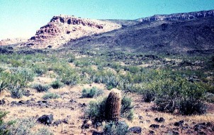
The midlatitude desert is found in inner Asia with great expanses in northern (Gobi desert) and northwestern China (Takla Makan desert), Kazakhstan, and Uzbekistan. The interior western United States (Southern Utah and Nevada, Arizona, New Mexico) has a midlatitude desert climate.
Controlling Factors
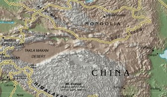
The midlatitude desert climate is controlled by the same factors as the tropical desert climates, the influence of high pressure, interior position, and rain shadow location. The Takla Makan desert exhibits this influence well as it lies in a depression ringed by mountains preventing even the most meager amount of moisture to penetrate to this interior location.
In the United States, the midlatitude desert lies in a region where high-level subsidence, especially pronounced in the summer, inhibits precipitation. During the winter, these regions are effectively cut-off from moist mT air masses and cold high pressure dominates the region. The midlatitude desert climate is found in the Great Basin of the United States. Here, east facing slopes lie on the leeward sides of mountains in the rain shadow of the westerly winds.

Figure \(\PageIndex{3}\) is a climate graph for Las Vegas, Nevada, labeled “BWk”, indicating a cold desert climate in the Köppen climate classification system. The horizontal axis shows the months January through December. The left vertical axis is labeled “Precipitation (mm)” and ranges from 0 to 1,200 millimeters. The right vertical axis is labeled “Temperature (°C)” and ranges from 0°C to 35°C. A red line with circular markers represents temperature. Temperatures rise steadily from about 8°C in January to a peak of approximately 32°C in July, then decline through autumn to about 9°C in December. The graph shows a large seasonal temperature range, with hot summers and cool winters. Precipitation values are not prominently displayed but remain very low throughout the year, consistent with a desert climate. The basic elements from the Climograph are :
Latitude/Longitude = 36N, 115 W
Average Annual Temperature (C) = 19
Annual Temperature Range (C) = 25.2
Total Annual Precipitation (mm) = 101.5
Summer Precipitation (mm) = 42.4
Winter Precipitation (mm) = 58.6
Distinguishing Characteristics
Temperature
Like its tropical equivalent, the midlatitude desert enjoys a high percentage of sunshine throughout the year. Dominant high pressure and lack of moisture combine to inhibit the production of clouds. The midlatitude desert similarly experiences large daily temperature ranges due to cloudless day and nights. However, the midlatitude desert experiences a larger annual temperature than the tropical desert. The southwest desert of the United States serves as a source region for cT air only during the summer because it is too cold to produce such an air mass during the winter. Wintertime incursions of cold cP is not uncommon.
| LOCATION |
JAN |
FEB |
MAR |
APR |
MAY |
JUN |
JUL |
AUG |
SEP |
OCT |
NOV |
DEC |
Mean Annual Temp |
Annual |
|
Las Vegas, NV (BWk) |
6.9 |
9.8 |
13.2 |
17.9 |
23.2 |
28.6 |
32.1 |
30.9 |
26.5 |
19.5 |
11.9 |
7.6 |
19 |
25.2 |
|
In Salah, Algeria (BWh)(oC) |
14.3 |
16.8 |
20.9 |
25.2 |
30.5 |
35.7 |
36.8 |
36.5 |
33 |
26.8 |
20.2 |
14 |
26.1 |
22.8 |
Precipitation
The midlatitude desert is considered an arid climate in which the total annual precipitation is less than half the annual potential evapotranspiration. Precipitation is sparse as the interior location is distant from a source of moisture. Or, the lack of rainfall is due to its leeward, rain shadow location. Like the tropical desert, precipitation is irregular and unreliable. Relative humidity is quite low when the region is dominated by cT air masses during the summer. Precipitation does fall during the U.S. southwest desert's "monsoon season" in July and August as Gulf air masses penetrate into this region. Combined with cyclonic precipitation during the winter the midlatitude desert receives much more precipitation than its tropical counterpart (Figure \(\PageIndex{4}\)).
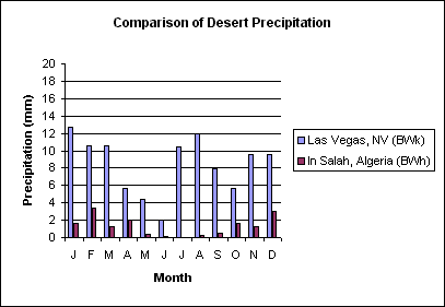
Figure \(\PageIndex{4}\) is a bar chart titled “Comparison of Desert Precipitation.”
The horizontal axis shows the months January through December. The vertical axis is labeled “Precipitation (mm)” and ranges from 0 to 20 millimeters.
The chart compares monthly precipitation for two desert locations:
- Las Vegas, NV (BWk), shown with light blue bars
- In Salah, Algeria (BWh), shown with dark red bars
Las Vegas receives measurable precipitation in most months, generally between 2 and 13 millimeters per month. The highest values occur in January, July, August, and December, while May and June are the driest months.
In Salah receives extremely little precipitation throughout the year. Most months record 0 to 3 millimeters of rainfall, with only small increases during a few months.