

5.8.5: Tropical Desert Climate
- Page ID
- 42647

\( \newcommand{\vecs}[1]{\overset { \scriptstyle \rightharpoonup} {\mathbf{#1}} } \)
\( \newcommand{\vecd}[1]{\overset{-\!-\!\rightharpoonup}{\vphantom{a}\smash {#1}}} \)
\( \newcommand{\dsum}{\displaystyle\sum\limits} \)
\( \newcommand{\dint}{\displaystyle\int\limits} \)
\( \newcommand{\dlim}{\displaystyle\lim\limits} \)
\( \newcommand{\id}{\mathrm{id}}\) \( \newcommand{\Span}{\mathrm{span}}\)
( \newcommand{\kernel}{\mathrm{null}\,}\) \( \newcommand{\range}{\mathrm{range}\,}\)
\( \newcommand{\RealPart}{\mathrm{Re}}\) \( \newcommand{\ImaginaryPart}{\mathrm{Im}}\)
\( \newcommand{\Argument}{\mathrm{Arg}}\) \( \newcommand{\norm}[1]{\| #1 \|}\)
\( \newcommand{\inner}[2]{\langle #1, #2 \rangle}\)
\( \newcommand{\Span}{\mathrm{span}}\)
\( \newcommand{\id}{\mathrm{id}}\)
\( \newcommand{\Span}{\mathrm{span}}\)
\( \newcommand{\kernel}{\mathrm{null}\,}\)
\( \newcommand{\range}{\mathrm{range}\,}\)
\( \newcommand{\RealPart}{\mathrm{Re}}\)
\( \newcommand{\ImaginaryPart}{\mathrm{Im}}\)
\( \newcommand{\Argument}{\mathrm{Arg}}\)
\( \newcommand{\norm}[1]{\| #1 \|}\)
\( \newcommand{\inner}[2]{\langle #1, #2 \rangle}\)
\( \newcommand{\Span}{\mathrm{span}}\) \( \newcommand{\AA}{\unicode[.8,0]{x212B}}\)
\( \newcommand{\vectorA}[1]{\vec{#1}} % arrow\)
\( \newcommand{\vectorAt}[1]{\vec{\text{#1}}} % arrow\)
\( \newcommand{\vectorB}[1]{\overset { \scriptstyle \rightharpoonup} {\mathbf{#1}} } \)
\( \newcommand{\vectorC}[1]{\textbf{#1}} \)
\( \newcommand{\vectorD}[1]{\overrightarrow{#1}} \)
\( \newcommand{\vectorDt}[1]{\overrightarrow{\text{#1}}} \)
\( \newcommand{\vectE}[1]{\overset{-\!-\!\rightharpoonup}{\vphantom{a}\smash{\mathbf {#1}}}} \)
\( \newcommand{\vecs}[1]{\overset { \scriptstyle \rightharpoonup} {\mathbf{#1}} } \)
\(\newcommand{\longvect}{\overrightarrow}\)
\( \newcommand{\vecd}[1]{\overset{-\!-\!\rightharpoonup}{\vphantom{a}\smash {#1}}} \)
\(\newcommand{\ket}[1]{\left| #1 \right>}\)
\(\newcommand{\bra}[1]{\left< #1 \right|}\)
\(\newcommand{\braket}[2]{\left< #1 \vphantom{#2} \right| \left. #2 \vphantom{#1} \right>}\)
\(\newcommand{\braopket}[3]{\left< #1 \vphantom{#2}\vphantom{#3} \right| #2 \vphantom{#1}\vphantom{#3} \left| #3 \vphantom{#1}\vphantom{#2} \right>}\)
\(\newcommand{\qmvec}[1]{\mathbf{\vec{#1}}}\)
\(\newcommand{\op}[1]{\hat{\mathbf{#1}}}\)
\(\newcommand{\expect}[1]{\langle #1 \rangle}\)
\(\newcommand{\dfn}[1]{\emph{\textbf{#1}}}\)
Geographical Distribution

The tropical desert is an environment of extremes: it is the driest and hottest place on earth. Rainfall is sporadic and in some years no measurable precipitation falls at all. The terribly dry conditions of the deserts is due to the year-round influence of subtropical high pressure and continentality.
Deserts are typically found in continental interiors of the subtropics and on the lee side of mountains in the midlatitudes. Cool coastal deserts are found where cold water upwells along a coast, stabilizing the air and preventing moisture formation like that near coastal Chile. Vast deserts cover much of north Africa (The Sahara), Saudi Arabia to Iran, Pakistan and western India. Tropical deserts are found in Baja California and interior Mexico in North America.
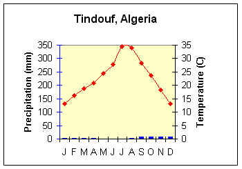
Figure \(\PageIndex{2}\) is a climate graph for Tindouf, Algeria.
The horizontal axis shows the months January through December. The left vertical axis is labeled “Precipitation (mm)” and ranges from 0 to 350 millimeters. The right vertical axis is labeled “Temperature (C)” and ranges from 0°C to 35°C.
Precipitation is represented by blue bars. Rainfall is extremely low throughout the year, with only trace amounts recorded in most months. Slight increases occur during late summer and autumn, but precipitation remains minimal overall.
Temperature is represented by a red line with diamond markers. Temperatures rise steadily from about 14°C in January to a peak near 35°C in July, then decline gradually to about 14°C by December. The graph shows a large annual temperature range and very hot summer conditions.
Controlling Factors
The most important controlling factor of the climate characteristics of the tropical desert climate is the year-round presence of subtropical high pressure. The descending air of the subtropical high adiabatically warms causing the air to dry out and inhibit condensation. Aridity also arises as distance from moisture sources increases. Leeward situations places one in the rain shadow which also promotes dry conditions. Cool coastal deserts are found along coasts where cold water is upwelling.
Distinguishing Characteristics
Temperature
The tropical desert has the highest mean annual temperature of any climate on Earth. The high temperatures are a result of the high sun angles throughout the year and having the highest percentage of sunshine of any climate. No month has an average temperature below 18oC (64.4oF) and many places have consecutive average monthly temperatures in the mid 30os Celsius (90oF). Daytime temperatures can reach 50oC (120oF) at low elevation inland deserts.
The sky in the tropical desert remains cloud-free due to the subsiding air of dominant high pressure resulting in large amounts of insolation. The cloudless skies during the day lets insolation in, but also lets much heat out at night. Without the absorptive blanket of clouds, longwave radiation emitted from the Earth readily escapes to space, chilling the nighttime desert air. The high energy input during the day and large loss at night results in an extremely large daily temperature range.
Precipitation
Precipitation in the tropical desert is very irregular and unreliable. Low latitude deserts average less than 25 cm (10 in) in a year. An entire year's worth of rain may fall in one downpour. The continental location of many tropical deserts places them far from a source of moisture, the ocean. Combine continentality with the strong subsidence of the subtropical high and you have one of the driest places on earth. Air subsiding from the subtropical high is adiabatically warmed which reduces the relative humidity of the air. Relative humidity can drop to 10% or less. The extremely low relative humidity causes evaporation of what little surface water there is. The subsiding air also promotes atmospheric stability, further inhibiting precipitation.

Climatologists describe the desert as an "arid" climate. An arid climate, as defined on the basis of the soil moisture balance, is one in which the annual precipitation is less than half of the annual potential evapotranspiration. In the tropical desert the only substantial source of surface water other than exotic streams is an oasis, where the groundwater table is near the surface.