

5.8.2: Tropical Monsoon Climate
- Page ID
- 42644

\( \newcommand{\vecs}[1]{\overset { \scriptstyle \rightharpoonup} {\mathbf{#1}} } \)
\( \newcommand{\vecd}[1]{\overset{-\!-\!\rightharpoonup}{\vphantom{a}\smash {#1}}} \)
\( \newcommand{\dsum}{\displaystyle\sum\limits} \)
\( \newcommand{\dint}{\displaystyle\int\limits} \)
\( \newcommand{\dlim}{\displaystyle\lim\limits} \)
\( \newcommand{\id}{\mathrm{id}}\) \( \newcommand{\Span}{\mathrm{span}}\)
( \newcommand{\kernel}{\mathrm{null}\,}\) \( \newcommand{\range}{\mathrm{range}\,}\)
\( \newcommand{\RealPart}{\mathrm{Re}}\) \( \newcommand{\ImaginaryPart}{\mathrm{Im}}\)
\( \newcommand{\Argument}{\mathrm{Arg}}\) \( \newcommand{\norm}[1]{\| #1 \|}\)
\( \newcommand{\inner}[2]{\langle #1, #2 \rangle}\)
\( \newcommand{\Span}{\mathrm{span}}\)
\( \newcommand{\id}{\mathrm{id}}\)
\( \newcommand{\Span}{\mathrm{span}}\)
\( \newcommand{\kernel}{\mathrm{null}\,}\)
\( \newcommand{\range}{\mathrm{range}\,}\)
\( \newcommand{\RealPart}{\mathrm{Re}}\)
\( \newcommand{\ImaginaryPart}{\mathrm{Im}}\)
\( \newcommand{\Argument}{\mathrm{Arg}}\)
\( \newcommand{\norm}[1]{\| #1 \|}\)
\( \newcommand{\inner}[2]{\langle #1, #2 \rangle}\)
\( \newcommand{\Span}{\mathrm{span}}\) \( \newcommand{\AA}{\unicode[.8,0]{x212B}}\)
\( \newcommand{\vectorA}[1]{\vec{#1}} % arrow\)
\( \newcommand{\vectorAt}[1]{\vec{\text{#1}}} % arrow\)
\( \newcommand{\vectorB}[1]{\overset { \scriptstyle \rightharpoonup} {\mathbf{#1}} } \)
\( \newcommand{\vectorC}[1]{\textbf{#1}} \)
\( \newcommand{\vectorD}[1]{\overrightarrow{#1}} \)
\( \newcommand{\vectorDt}[1]{\overrightarrow{\text{#1}}} \)
\( \newcommand{\vectE}[1]{\overset{-\!-\!\rightharpoonup}{\vphantom{a}\smash{\mathbf {#1}}}} \)
\( \newcommand{\vecs}[1]{\overset { \scriptstyle \rightharpoonup} {\mathbf{#1}} } \)
\(\newcommand{\longvect}{\overrightarrow}\)
\( \newcommand{\vecd}[1]{\overset{-\!-\!\rightharpoonup}{\vphantom{a}\smash {#1}}} \)
\(\newcommand{\ket}[1]{\left| #1 \right>}\)
\(\newcommand{\bra}[1]{\left< #1 \right|}\)
\(\newcommand{\braket}[2]{\left< #1 \vphantom{#2} \right| \left. #2 \vphantom{#1} \right>}\)
\(\newcommand{\braopket}[3]{\left< #1 \vphantom{#2}\vphantom{#3} \right| #2 \vphantom{#1}\vphantom{#3} \left| #3 \vphantom{#1}\vphantom{#2} \right>}\)
\(\newcommand{\qmvec}[1]{\mathbf{\vec{#1}}}\)
\(\newcommand{\op}[1]{\hat{\mathbf{#1}}}\)
\(\newcommand{\expect}[1]{\langle #1 \rangle}\)
\(\newcommand{\dfn}[1]{\emph{\textbf{#1}}}\)
Geographical Distribution
The tropical monsoon climate experiences abundant rainfall like that of the tropical rain forest climate, but it is concentrated in the high-sun season. Being located near the equator, the tropical monsoon climate experiences warm temperatures throughout the year.
The monsoon climate is found along the coastal regions of southwest India, Sri Lanka, Bangladesh, Myanmar, Southwestern Africa, French Guiana, and northeast and southeastern Brazil.
Controlling Factors
The major controlling factor over the monsoon climate is its relationship to the monsoon circulation. Recall that the monsoon is a seasonal change in wind direction. The "classic" monsoon circulation of Asia exhibits an onshore flow of air (air moving from ocean towards land) during the summer or high-sun season, and offshore air flow (air moving from land toward water) during the winter or low-sun season. The change in direction is due to the difference in the way water and land heat.
Changing pressure patterns that affect the seasonality of precipitation also occur in Africa. During the high-sun season, the ITCZ induces rain while the subtropical high creates dry conditions. The monsoon climate of Africa, and South America for that matter, are typically located along tradewind coasts.
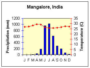
Figure \(\PageIndex{1}\) is a climate graph for Mangalore, India. The graph displays monthly precipitation and temperature throughout the year.
- The horizontal axis shows the months January through December, labeled J, F, M, A, M, J, J, A, S, O, N, D.
- The left vertical axis is labeled “Precipitation (mm)” and ranges from 0 to 1,200 millimeters.
- The right vertical axis is labeled “Temperature (C)” and ranges from 0 to 35 degrees Celsius.
Precipitation is shown with blue bars. Rainfall is very low from January through April, increases in May, and becomes extremely heavy during the summer monsoon season from June through September. The wettest months are June and July, with rainfall approaching or exceeding 1,000 millimeters. Rainfall decreases during October and returns to low levels by November and December.
Temperature is shown by a red line with diamond markers. Temperatures remain warm throughout the year, generally between 26°C and 30°C. The highest temperatures occur just before the monsoon season, around April and May, followed by a slight decrease during the rainy months.
Distinguishing Characteristics
Temperature
Like in the tropical rain forest climate, temperatures remain high all year in the monsoon climate. As shown in the climograph for Mangalore, India (Figure \(\PageIndex{1}\)), the average annual temperature is 27.05oC (80.7oF) but only has an annual temperature range of 3.6oC (2oF). The monsoon climate's temperature range is somewhat similar to that of the rain forest (shown in Figure \(\PageIndex{2}\)), but it exhibits a slightly different temporal pattern. In the rain forest we noted two periods of maximum temperature in association with the migration of the Sun's vertical rays. The monsoon climate tends to have its highest temperature just before rainy period. Once the rainy period starts, clouds block incoming solar radiation to reduce monthly temperatures.
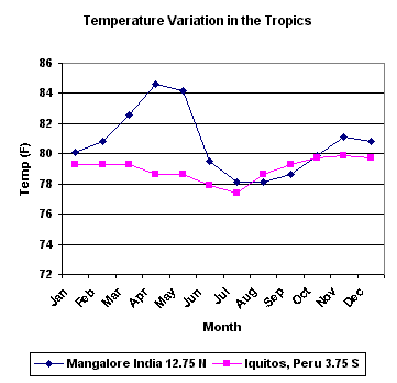
Figure \(\PageIndex{2}\) is a line graph titled “Temperature Variation in the Tropics.” The horizontal axis is labeled “Month” and shows the months January through December. The vertical axis is labeled “Temp (F)” and ranges from approximately 72°F to 86°F. The graph compares monthly temperatures for two tropical locations:
- Mangalore, India (12.75° N), shown by a blue line with diamond markers
- Iquitos, Peru (3.75° S), shown by a magenta line with square markers
Mangalore, India experiences greater annual temperature variation. Temperatures rise from about 80°F in January to a peak of approximately 85°F in April, then decline sharply during the summer monsoon season to around 78°F in August before increasing again to about 81°F by December. Iquitos, Peru maintains nearly constant temperatures throughout the year. Values remain close to 78–80°F, showing only minor fluctuations from month to month.
Precipitation
Seasonality of its precipitation is the hallmark and most well-known characteristic of the monsoon climate. Many think that the term "monsoon" means wet weather, when in fact it describes an atmospheric circulation pattern. Though the annual amount of precipitation is quite similar to that of the rain forest, monsoon precipitation is concentrated into the high-sun season. Maritime equatorial and maritime tropical air masses travel from the ocean on to land during the summer, where they are uplifted by either convection or convergence of air to induce condensation. Locally, orographic uplift is an important mechanism for promoting precipitation. As air travels into the Indian subcontinent, it is uplifted by the Himalayas, causing cloud development and precipitation.
The low-sun season is characterized by a short drought season when high pressure inhibits precipitation formation. In the case of the Asian monsoon, the replacement of the thermal low with the subsidence of the Siberian High suppresses uplift. Air masses that dominate this period are dry given their continental origin (cT, cP) or stability (mTs).