

4.10: Review and Additional Resources
- Page ID
- 40064

\( \newcommand{\vecs}[1]{\overset { \scriptstyle \rightharpoonup} {\mathbf{#1}} } \)
\( \newcommand{\vecd}[1]{\overset{-\!-\!\rightharpoonup}{\vphantom{a}\smash {#1}}} \)
\( \newcommand{\dsum}{\displaystyle\sum\limits} \)
\( \newcommand{\dint}{\displaystyle\int\limits} \)
\( \newcommand{\dlim}{\displaystyle\lim\limits} \)
\( \newcommand{\id}{\mathrm{id}}\) \( \newcommand{\Span}{\mathrm{span}}\)
( \newcommand{\kernel}{\mathrm{null}\,}\) \( \newcommand{\range}{\mathrm{range}\,}\)
\( \newcommand{\RealPart}{\mathrm{Re}}\) \( \newcommand{\ImaginaryPart}{\mathrm{Im}}\)
\( \newcommand{\Argument}{\mathrm{Arg}}\) \( \newcommand{\norm}[1]{\| #1 \|}\)
\( \newcommand{\inner}[2]{\langle #1, #2 \rangle}\)
\( \newcommand{\Span}{\mathrm{span}}\)
\( \newcommand{\id}{\mathrm{id}}\)
\( \newcommand{\Span}{\mathrm{span}}\)
\( \newcommand{\kernel}{\mathrm{null}\,}\)
\( \newcommand{\range}{\mathrm{range}\,}\)
\( \newcommand{\RealPart}{\mathrm{Re}}\)
\( \newcommand{\ImaginaryPart}{\mathrm{Im}}\)
\( \newcommand{\Argument}{\mathrm{Arg}}\)
\( \newcommand{\norm}[1]{\| #1 \|}\)
\( \newcommand{\inner}[2]{\langle #1, #2 \rangle}\)
\( \newcommand{\Span}{\mathrm{span}}\) \( \newcommand{\AA}{\unicode[.8,0]{x212B}}\)
\( \newcommand{\vectorA}[1]{\vec{#1}} % arrow\)
\( \newcommand{\vectorAt}[1]{\vec{\text{#1}}} % arrow\)
\( \newcommand{\vectorB}[1]{\overset { \scriptstyle \rightharpoonup} {\mathbf{#1}} } \)
\( \newcommand{\vectorC}[1]{\textbf{#1}} \)
\( \newcommand{\vectorD}[1]{\overrightarrow{#1}} \)
\( \newcommand{\vectorDt}[1]{\overrightarrow{\text{#1}}} \)
\( \newcommand{\vectE}[1]{\overset{-\!-\!\rightharpoonup}{\vphantom{a}\smash{\mathbf {#1}}}} \)
\( \newcommand{\vecs}[1]{\overset { \scriptstyle \rightharpoonup} {\mathbf{#1}} } \)
\(\newcommand{\longvect}{\overrightarrow}\)
\( \newcommand{\vecd}[1]{\overset{-\!-\!\rightharpoonup}{\vphantom{a}\smash {#1}}} \)
\(\newcommand{\ket}[1]{\left| #1 \right>}\)
\(\newcommand{\bra}[1]{\left< #1 \right|}\)
\(\newcommand{\braket}[2]{\left< #1 \vphantom{#2} \right| \left. #2 \vphantom{#1} \right>}\)
\(\newcommand{\braopket}[3]{\left< #1 \vphantom{#2}\vphantom{#3} \right| #2 \vphantom{#1}\vphantom{#3} \left| #3 \vphantom{#1}\vphantom{#2} \right>}\)
\(\newcommand{\qmvec}[1]{\mathbf{\vec{#1}}}\)
\(\newcommand{\op}[1]{\hat{\mathbf{#1}}}\)
\(\newcommand{\expect}[1]{\langle #1 \rangle}\)
\(\newcommand{\dfn}[1]{\emph{\textbf{#1}}}\)
Summary
Review and assess your learning. Start with the "Important Terms and Concepts" to ensure you know the terminology related to the topic of the chapter and concepts discussed. Move on to the "Review Questions" to answer critical thinking questions about concepts and processes discussed in the chapter. Finally, test your overall understanding by taking the "Self-assessment quiz".
-
- hydrosphere
- often called the "water sphere" as it includes all the earth's water found in the oceans, glaciers, streams, lakes, the soil, groundwater, and in the air.
-
- hydrologic cycle
- aka water cycle. the cycling of water through the earth system. It is a cycle of energy as well.
-
- soil water
- the water that is immediately available to plants.
-
- groundwater
- occupies the zone of saturation. Found in aquifers and replenished by percolation of water from the zone of aeration downward to the zone of saturation, or in the recharge zone of a confined aquifer.
-
- evaporation
- the phase change of liquid water into a vapor (gas)
-
- latent energy
- "locked up" in the water molecule when water undergoes the phase change from a liquid to a gas.
-
- precipitation
- droplets of water that fall from the clouds to the earth
-
- interception
- Precipitation that collects on the leaves or stems of plants
-
- infiltration
- refers to water that penetrates into the surface of soil.
-
- zone of aeration
- aka "unsaturated zone", includes soil water zone. See image under "zone of saturation"
-
- zone of saturation
- includes ground water

-
- groundwater zone
- included in zone of saturation. See image under "zone of saturation"
-
- water table
- divides the zone of aeration from the zone of saturation. The height of the water table will fluctuate with precipitation, increasing in elevation during wet periods and decreasing during dry.
-
- hygroscopic water
- a microscopic film of water surrounding soil particles
-
- capillary water
- held by cohesive forces between the films of hygroscopic water
-
- wilting point
- At this point the plant cannot pull water from the plant-rooting zone and it wilts
-
- gravity water
- water moved through the soil by the force of gravity
-
- field capacity
- The amount of water held in the soil after excess water has drained
-
- available water
- The difference between the wilting point and the field capacity
-
- percolation
- the movement of water downward through the soil
-
- seepage
- water that moves downward through the soil toward a stream channel of large body of water
-
- aquifer
- bodies of earth material that have the ability to hold and transmit water
-
- aquiclude
- dense impermeable layers of earth material
-
- hydraulic gradient
- the difference in elevation between two points on the water table divided by the horizontal distance between them
-
- groundwater flow rate
- permeability X hydraulic gradient
-
- runoff
- precipitation that moves across the surface
-
- unconfined flow
- moves across the surface in broad sheets of water often creating sheet erosion
-
- confined flow
- water confined to channels
-
- depression storage
- Water that became trapped in depressions
-
- stream discharge
- the volume of water passing through a particular cross-section of a stream in a unit of time
-
- stream hydrograph
- illustrates the relationship between discharge and runoff
-
- water balance
- an accounting of the inputs and outputs of water
-
- precipitation
- makes up the primarily supply of water to the surface.
-
- actual evapotranspiration
- the amount of water delivered to the air from evaporation and transpiration
-
- evaporation
- the phase change from a liquid to a gas releasing water from a wet surface into the air above
-
- transpiration
- represents a phase change when water is released into the air by plants
-
- evapotranspiration
- combined transfer of water into the air by evaporatihygroscopicspiration
-
- potential evapotranspiration
- the amount of water that would be evaporated under an optimal set of conditions, among which is an unlimited supply of water
-
- soil moisture storage
- the amount of water held in the soil at any particular time
-
- change in soil moisture storage
- the amount of water that is being added to or removed from what is stored
-
- deficit
- demand for water exceeds that which is actually available; when potential evapotranspiration exceeds actual evapotranspiration (PE>AE)
-
- surplus
- when P exceeds PE and the soil is at its field capacity (saturated); we have more water than we actually need to use given the environmental conditions at a place
-
- soil moisture recharge
- Precipitation satisfies the need for water with water left over and begins to replenish the soil moisture
-
- soil moisture utilization
- precipitation is no longer is able to meet the demands of potential evapotranspiration. Plants must extract water that is stored in the soil from the previous months
-
- Phase change
-
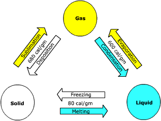
Phase Changes of Water
-
- Evaporation
- the phase change of a liquid to a gas
-
- Transpiration
- the transfer of water into the air via leaf pores or stomata.
-
- Humidity
- a measure of the water vapor content of the air.
-
- Saturation
- "holding all the moisture it can"
-
- Specific humidity
- the weight of water vapor in the air per unit weight of air, which includes the weight of water vapor.
-
- Mixing ratio
- the weight of water vapor per unit weight of dry air.
-
- Vapor pressure
- the partial pressure created by water vapor.
-
- Saturation vapor pressure
- the pressure that water vapor creates when the air is fully saturated.
-
- Relative humidity
- the ratio of the amount of water vapor in the air to its saturation point.
-
- Condensation
- the phase change of water vapor into a liquid
-
- Condensation nuclei
- act as a platform for condensation to take place, increasing the size of a droplet and decreasing surface tension.
-
- Dew
- small droplets of water that form as a result of condensation.
-
- Fog
- a cloud that forms near the ground
-
- Radiation Fog
- forms during the evening under cloudless skies and with little to no wind
-
- Steam Fog
- occurs when cool dry air settles over a warm, moist surface
-
- Advection Fog
- forms when warm and moist air travels over a cool surface.
-
- Upslope Fog
- forms when moist air if forced up a slope
-
- Frontal Fog
- associated with weather fronts, especially a warm front.
-
- Saturated Adiabatic rate
- If the air is saturated, the rate of temperature change is .6oC/100 meters.
-
- Dry Adiabatic Rate
- If the air is dry, the rate of temperature change is 1oC/100 meters.
-
- Stable air
- Stable atmospheric conditions prevail when the environmental lapse rate is less than the saturated adiabatic rate.
-
- Unstable air
- Air is unstable when the environmental lapse rate is greater than the dry adiabatic rate.
-
- Cirrus cloud
- appear as wispy thin veils or detached filaments composed mostly of ice.
-
- Cirrostratus
- a transparent, whitish veil of cloud that usually covers much of the sky.
-
- Altostratus
- formless layer of grayish cloud that cover most if not all the sky.
-
- Stratus
- appear as a uniform dark-gray layer of clouds covering the entire sky.
-
- Cumulus
- appear as small, cotton ball-like clouds that generally form by convection.
-
- Nimbostratus
- dark-gray layer of clouds that cover the entire sky. The prefix "nimbo" indicates that these clouds are precipitating.
-
- Cumulonimbus
- form during very unstable conditions.
Briefly describe what the hydrologic cycle is.
- Answer
-
The hydrologic cycle or water cycle is the pathway through which water moves in the Earth system. It is a cycle of energy as well as moisture.
Compare and contrast soil water and groundwater.
- Answer
-
Soil water is held in the soil moisture zone that lies in the zone of aeration. Groundwater is held in the zone of saturation. Soil water is directly available for plants to use, ground water is not.
How do plants affect the hydrologic cycle?
- Answer
-
Plants affect the water cycle though by extracting water from the soil moisture zone and passing it to the atmosphere. Water moves as through fall through plant canopy.
What impact does soil texture have on field capacity?
- Answer
-
The field capacity is the maximum amount of water held in the soil after it has bee drained by gravity. Field capacity is higher in fine textured soils because there is more pore space per unit volume than for coarse textured soils.
What affects the permeability of subsurface warth materials?
- Answer
-
Permeability is the ability for water to move through earth material. The connectivity of pore spaces largely controls permeability. Large, well-connected pore space results in greater permeability. Thus, coarse soils are more permeable than fine textured soils.
How does soil texture affect available water?
- Answer
-
Finer textured soils hold more water and thus have more available water than coarse textured soils.
Compare and contrast an aquiclude with an aquifier.
- Answer
-
An aquifer is a body of earth material able to hold and transmit groundwater in economical amounts. An aquiclude is far less permeable and cannot transmit water through it.
Describe the effect of urbanization on a stream hydrograph.
- Answer
-
Urbanization can decrease the lag time between maximum precipitation and runoff, and increase and steepen the recessional limb of a hydrograph.
What is potential evapotranspiration?
- Answer
-
Evapotranspiration is the amount of water evaporated and transpired under an unlimited supply of water. Fundamentally it is determined by energy input to the environment. Evapotranspiration can be thought of as "water need”.
Under what conditions does a soil water deficit occur?
- Answer
-
A soil water deficit occurs when potential evapotranspiration exceeds precipitation and the soil water storage is zero (dry soil).
Under what conditions does a soil water surplus occur?
- Answer
-
A soil water surplus occurs when precipitation exceeds potential evapotranspiration and the soil is at field capacity.
- In soil moisture budgeting, potential evapotranspiration is largely dependent on
- soil texture
- energy input
- plant type
- all the above
- The largest store of fresh water in the hydrosphere is
- the ocean
- glaciers
- the Great Lakes
- ground water
- Over pumping of ground water could lead to
- lowered water tables
- land subsidence
- decreased aquifer permeability
- all the above
- Infiltration of water into the soil
- is higher for coarse textured soil
- is higher when the soil is dry
- is higher for vegetated surfaces
- is affected by all the above
- Which of the following soil texture classes would have the largest available water?
- sand
- silt
- clay
- loam
- The water held that is "bound" the tightest to soil particles is
- hygroscopic water
- capillary water
- gravity water
- pore water
- The process whereby water drips from leaf-to-leaf finally making it to the ground is called
- through flow
- stem flow
- through fall
- interception
- The zone of saturation is the
- soil water zone
- intermediate zone
- aeration zone
- ground water zone
- The point at which plants can no longer extract water from the soil is called the
- field capacity point
- dryness point
- wilting point
- none of the above
- If PE is greater than AE and P, and the soil is dry, then
- soil water recharge is likely to occur
- soil water surplus is likely to occur
- soil water utilization is likely to occur
- soil water deficit is likely to occur
- The highest relative humidity for the day
- is usually around sunrise when the air temperature is coolest.
- is usually later in the afternoon when the air temperature is the warmest.
- is right at noon
- is at midnight
- If the temperature of the air increases without additional water vapor being added to the air the relative humidity will likely
- increase
- decrease
- stay the same
- temperature has no impact on relative humidity
- On a day in mid-June a parcel of air and the air that surrounds it at ground level are found to have the same temperature. You also find that the ELR is greater than the DAR on that day. If the parcel is given an upward push
- the air would be stable
- the air would be unstable
- the parcel and surrounding air will still have the same temperature
- none of the above
- A fog that forms when warm, moist air comes in contact with a cool surface is called
- a steam fog
- an upslope fog
- a radiation fog
- an advection fog
- The ice crystal growth model
- applies to cold clouds
- applies to mid and high latitude situations
- requires the presence of super-cooled water
- all the above
- The weight of water vapor per unit weight of dry air is
- the mixing ratio
- the relative humidity
- the absolute humidity
- the vapor pressure
- Thin, wispy high clouds composed of ice crystals are
- cumulus clouds
- cirrus clouds
- stratus clouds
- cumulonimbus clouds
- Latent heat
- is stored in water molecules when condensation occurs
- is converted to sensible heat when water vapor condenses
- is used to raise the temperature of the water
- relates to none of the above
- Radiation fog
- is more likely to form during the day
- is more likely to form at night
- forms when it is windy
- none of the above
- Frost is a product of
- evaporation
- condensation
- sublimation
- deposition
- Answer
-
- B
- B
- D
- D
- D
- A
- A
- D
- C
- D
- A
- B
- B
- D
- D
- A
- B
- B
- B
- D
Additional Resources
Use these resources to further explore the world of geography
- OpenAI. (2026). ChatGPT (GPT-4o version) [Large language model]. https://chatgpt.com
- Google. (2026). Gemini (Gemini 1.5 Pro version) [Large language model]. google.com
- elmenstine, A. M. (2020, August 28). Interesting and weird water facts. ThoughtCo.
- National Oceanic and Atmospheric Administration. (n.d.). The marine layer.
- National Oceanic and Atmospheric Administration. (2019, February 1). Water cycle.
- National Weather Service. (n.d.). Fog types. National Oceanic and Atmospheric Administration.
- National Weather Service. (n.d.). Fog and boundary layer clouds: Fog training series [PDF]. National Oceanic and Atmospheric Administration.
- National Oceanic and Atmospheric Administration. (n.d.). NWS cloud chart. JetStream.
- National Weather Service. (n.d.). Cloud classification.
- National Oceanic and Atmospheric Administration. (2023, March 28). Ten basic clouds. JetStream.
- National Oceanic and Atmospheric Administration. (2023, October 27). Clouds. JetStream.
- National Oceanic and Atmospheric Administration. (n.d.). Global atmospheric circulations.
- National Oceanic and Atmospheric Administration. (n.d.). Weather systems and patterns.
- Ritter, M. E. (2020). The physical environment: An introduction to physical geography. (L. Pitts, Ed.).
- Riebeek, H. (2005, May 10). Cloudy Earth. NASA Earth Observatory.
- ThoughtCo. (2021, February 16). The 5 states of matter.
- U.S. Geological Survey. (2024, May 23). Water cycle.
- Explore NASA Earth Observatory’s Lake Victoria’s rising waters. to learn how changing water levels can affect shorelines, ecosystems, and nearby communities. This resource helps students connect climate variability, precipitation, flooding, satellite observation, and human-environment interaction to physical geography.
- Explore NASA Earth Observatory’s World of change: Evaporation of the Aral Sea to examine how environmental change can transform a major body of water over time. This resource helps students connect water use, climate, land change, satellite imagery, and human-environment interaction to physical geography.
- Explore NASA Earth Observatory’s Lake Chad to learn how changes in water levels affect landscapes, ecosystems, and nearby communities. This resource helps students connect climate variability, drought, land use, and satellite observation to physical geography.
- Explore the U.S. Geological Survey’s Groundwater Climate Response Network mapper to examine how groundwater levels respond to climate conditions over time. This resource helps students connect groundwater, drought, precipitation, long-term environmental monitoring, and map-based data analysis to physical geography.
- Explore the U.S. Geological Survey’s Water resources to learn how scientists study groundwater, rivers, lakes, water quality, and water availability. This resource helps students connect hydrology, climate, human water use, and long-term environmental monitoring to physical geography.