

4.4.1: Fog
- Page ID
- 40048

\( \newcommand{\vecs}[1]{\overset { \scriptstyle \rightharpoonup} {\mathbf{#1}} } \)
\( \newcommand{\vecd}[1]{\overset{-\!-\!\rightharpoonup}{\vphantom{a}\smash {#1}}} \)
\( \newcommand{\dsum}{\displaystyle\sum\limits} \)
\( \newcommand{\dint}{\displaystyle\int\limits} \)
\( \newcommand{\dlim}{\displaystyle\lim\limits} \)
\( \newcommand{\id}{\mathrm{id}}\) \( \newcommand{\Span}{\mathrm{span}}\)
( \newcommand{\kernel}{\mathrm{null}\,}\) \( \newcommand{\range}{\mathrm{range}\,}\)
\( \newcommand{\RealPart}{\mathrm{Re}}\) \( \newcommand{\ImaginaryPart}{\mathrm{Im}}\)
\( \newcommand{\Argument}{\mathrm{Arg}}\) \( \newcommand{\norm}[1]{\| #1 \|}\)
\( \newcommand{\inner}[2]{\langle #1, #2 \rangle}\)
\( \newcommand{\Span}{\mathrm{span}}\)
\( \newcommand{\id}{\mathrm{id}}\)
\( \newcommand{\Span}{\mathrm{span}}\)
\( \newcommand{\kernel}{\mathrm{null}\,}\)
\( \newcommand{\range}{\mathrm{range}\,}\)
\( \newcommand{\RealPart}{\mathrm{Re}}\)
\( \newcommand{\ImaginaryPart}{\mathrm{Im}}\)
\( \newcommand{\Argument}{\mathrm{Arg}}\)
\( \newcommand{\norm}[1]{\| #1 \|}\)
\( \newcommand{\inner}[2]{\langle #1, #2 \rangle}\)
\( \newcommand{\Span}{\mathrm{span}}\) \( \newcommand{\AA}{\unicode[.8,0]{x212B}}\)
\( \newcommand{\vectorA}[1]{\vec{#1}} % arrow\)
\( \newcommand{\vectorAt}[1]{\vec{\text{#1}}} % arrow\)
\( \newcommand{\vectorB}[1]{\overset { \scriptstyle \rightharpoonup} {\mathbf{#1}} } \)
\( \newcommand{\vectorC}[1]{\textbf{#1}} \)
\( \newcommand{\vectorD}[1]{\overrightarrow{#1}} \)
\( \newcommand{\vectorDt}[1]{\overrightarrow{\text{#1}}} \)
\( \newcommand{\vectE}[1]{\overset{-\!-\!\rightharpoonup}{\vphantom{a}\smash{\mathbf {#1}}}} \)
\( \newcommand{\vecs}[1]{\overset { \scriptstyle \rightharpoonup} {\mathbf{#1}} } \)
\(\newcommand{\longvect}{\overrightarrow}\)
\( \newcommand{\vecd}[1]{\overset{-\!-\!\rightharpoonup}{\vphantom{a}\smash {#1}}} \)
\(\newcommand{\ket}[1]{\left| #1 \right>}\)
\(\newcommand{\bra}[1]{\left< #1 \right|}\)
\(\newcommand{\braket}[2]{\left< #1 \vphantom{#2} \right| \left. #2 \vphantom{#1} \right>}\)
\(\newcommand{\braopket}[3]{\left< #1 \vphantom{#2}\vphantom{#3} \right| #2 \vphantom{#1}\vphantom{#3} \left| #3 \vphantom{#1}\vphantom{#2} \right>}\)
\(\newcommand{\qmvec}[1]{\mathbf{\vec{#1}}}\)
\(\newcommand{\op}[1]{\hat{\mathbf{#1}}}\)
\(\newcommand{\expect}[1]{\langle #1 \rangle}\)
\(\newcommand{\dfn}[1]{\emph{\textbf{#1}}}\)
How Fog Forms Near the Surface
Fog is a cloud that develops at or near the surface of the Earth. Like other forms of condensation, its creation requires the air temperature to drop to the dew point. This cooling happens through either diabatic processes, such as contact with a cold surface, or adiabatic processes, which involve the expansion of rising air.
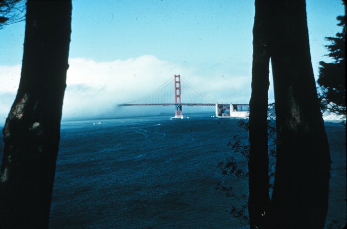
Advection fog occurs when a warm, moist mass of air moves over a cooler surface. As the air travels, heat is transferred from the air to the ground, cooling the air layer directly above the surface until it reaches saturation. This type of fog is frequent in the American Midwest during the spring when moist air from the Gulf of Mexico flows over cold or snow-covered land. It is also common in San Francisco as Pacific air masses move over the cold California Current.
Radiation fog typically forms on clear nights with calm winds. Without clouds to trap heat, the ground quickly emits longwave radiation into space, causing the surface to cool. The air in contact with this cold ground then loses heat and reaches its dew point. This fog often disappears or burns off as the sun warms the surface in the morning. Variations in surface types, such as the difference between a grass field and an asphalt lot, can affect how close to the ground the fog remains due to differing rates of heating.

Figure \(\PageIndex{2}\) shows a comparison of fog height over two different surface types: a grassy field and a paved parking lot, illustrating how surface temperature affects fog formation and height.
Surface types (foreground)
- The left side shows a grassy field.
- The right side shows a parking lot with paved surface and parked vehicles.
- Function: Different surface materials absorb and release heat at different rates.
Fog layer (middle)
- A continuous layer of fog extends across both surfaces.
- Over the grassy field, the fog is lower and closer to the ground.
- Over the parking lot, the fog is higher above the surface.
- Function: The height of the fog layer reflects differences in surface heating.
Cause of the difference
- The grassy field remains cooler, so the air near the ground reaches saturation closer to the surface.
- The parking lot warms more quickly, heating the air near the surface.
- This reduces near-surface saturation, pushing the fog layer upward.
- Function: Surface temperature differences control the vertical position of condensation.
Text in the image
- “Fog lower over cool field” points to the left side.
- “Fog higher over warm parking lot” points to the right side.
- Function: Labels explicitly identify how surface temperature influences fog height.
A radiation fog is shown in Figure \(\PageIndex{2}\). To the left of the picture is a grass field and to the right is an asphalt parking lot. As the sun heats the surface during the early morning it "burns off" the fog. Because the grass field has a higher albedo and cooler surface, the fog is closer to the surface than over the warmer parking lot.

Figure \(\PageIndex{3}\) is an infographic compares four types of fog formation near Earth’s surface: advection fog, radiation fog, steam fog, and upslope fog. Each panel shows a different set of environmental conditions that cool air to saturation and produce fog.
Advection fog
In the upper left panel, warm, moist air moves horizontally over a cooler surface, such as cold water or cool land. Heat is removed from the air through contact with the cooler surface. As the air cools to its dew point, fog forms. This process is a type of diabatic cooling because heat is transferred out of the air.
Radiation fog
In the upper right panel, land cools at night under clear skies and calm winds. Arrows show longwave radiation leaving the surface. The ground cools the air directly above it, and that near-surface air reaches its dew point, forming fog close to the ground. This is also diabatic cooling because energy is lost from the surface and nearby air.
Steam fog
In the lower left panel, cold, dry air moves across warmer water. Water vapor rises from the warm surface through evaporation. As the cold air gains moisture and cools relative to the warm vapor source, condensation forms above the water. The fog appears as rising vapor over the water surface.
Upslope fog
In the lower right panel, moist air moves toward a slope and is forced upward. As the air rises, it expands and cools. When it reaches the dew point, condensation occurs and fog forms along the slope. This process results from adiabatic cooling, which occurs because the air cools as it rises and expands.
Overall, the infographic shows that fog can form in several different ways: by warm air moving over a cold surface, by nighttime cooling over land, by cold air moving over warm water, or by moist air rising up terrain. In all four cases, the air reaches saturation and condensation produces fog.
Steam fog illustrated in Figure \(\PageIndex{3}\), happens when a cold, dry air mass moves over a warm and moist body of water. The moisture gradient allows water to evaporate into the cool air. Because the cool air has a low saturation point, the added water vapor quickly condenses, creating a steaming appearance.
Upslope fog, shown in Figure \(\PageIndex{3}\), is generated when moist air is physically forced up a rising land slope. As the air moves higher, atmospheric pressure decreases, causing the air to expand and cool adiabatically. If it cools enough to reach the dew point, fog develops. An example of this is seen when air from the Gulf of Mexico moves west across the Great Plains toward the Rocky Mountains.
Frontal fog is often linked to weather fronts, particularly warm fronts. In this scenario, warm and moist air rises over a mass of cooler, drier air. As rain falls from the upper warm layer into the lower cool layer, some of the water evaporates. This added moisture raises the humidity of the cool air until it becomes saturated and forms fog.
Geographical Patterns of Fog
There is a definite geographical pattern to the formation of fogs. Figure \(\PageIndex{4}\) shows the spatial pattern of fogs over the United States. First note that radiation fog is pretty common over much of the country as no special landscape features like mountains or ocean currents are needed to create it. Advection fog is common along coasts where air originating over warm water travels over cooler water or land surfaces to induce condensation and cloud formation near the ground. Upslope fog is common through the western Great Plains and eastern slope of the Rocky Mountains as warm and moist air, often originating in the Gulf of Mexico, works its way toward higher elevation. The gentle uplift provided induces adiabatic cooling and saturation of the air with subsequent condensation and fog formation.
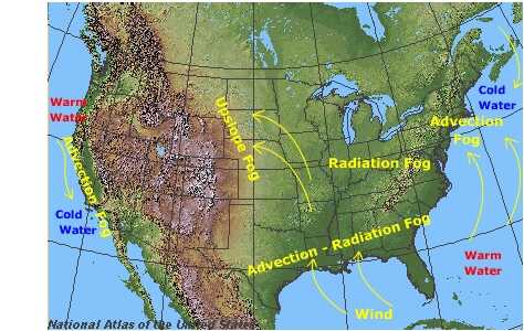
Figure \(\PageIndex{4}\) is a map of the continental United States shows where three types of fog commonly occur: advection fog, radiation fog, and upslope fog.
Advection fog is shown mainly along the Pacific Coast and Atlantic Coast. On the West Coast, it is associated with moist air moving over cold coastal water. On the East Coast, it is linked to areas where warm and cold ocean waters interact. These coastal regions show that advection fog forms where moist air moves over a cooler surface and cools to saturation.
Radiation fog is shown across large parts of the central and eastern United States, especially inland regions away from strong ocean influence. These areas suggest that radiation fog forms widely where the ground cools under clear skies and calm conditions, cooling the air near the surface to the dew point.
Upslope fog is shown in the Great Plains and Rocky Mountain region. Arrows indicate air moving from the central plains toward higher terrain in the Rockies. As the air rises over the terrain, it expands and cools, forming fog through adiabatic cooling.
The map also includes arrows showing wind and air movement, which connect moisture sources such as coastal waters or the Gulf region to the fog formation areas. Coastal waters are labeled as warm water or cold water, helping explain where advection fog forms.
Overall, the map shows that fog distribution in the United States depends on local geography, surface temperature, terrain, and airflow. Coastal fog is strongly influenced by ocean-water temperatures, inland fog often forms through nighttime surface cooling, and mountain-region fog forms when moist air is forced upward.