

3.1.2: The Earth in Space
- Page ID
- 39989

\( \newcommand{\vecs}[1]{\overset { \scriptstyle \rightharpoonup} {\mathbf{#1}} } \)
\( \newcommand{\vecd}[1]{\overset{-\!-\!\rightharpoonup}{\vphantom{a}\smash {#1}}} \)
\( \newcommand{\dsum}{\displaystyle\sum\limits} \)
\( \newcommand{\dint}{\displaystyle\int\limits} \)
\( \newcommand{\dlim}{\displaystyle\lim\limits} \)
\( \newcommand{\id}{\mathrm{id}}\) \( \newcommand{\Span}{\mathrm{span}}\)
( \newcommand{\kernel}{\mathrm{null}\,}\) \( \newcommand{\range}{\mathrm{range}\,}\)
\( \newcommand{\RealPart}{\mathrm{Re}}\) \( \newcommand{\ImaginaryPart}{\mathrm{Im}}\)
\( \newcommand{\Argument}{\mathrm{Arg}}\) \( \newcommand{\norm}[1]{\| #1 \|}\)
\( \newcommand{\inner}[2]{\langle #1, #2 \rangle}\)
\( \newcommand{\Span}{\mathrm{span}}\)
\( \newcommand{\id}{\mathrm{id}}\)
\( \newcommand{\Span}{\mathrm{span}}\)
\( \newcommand{\kernel}{\mathrm{null}\,}\)
\( \newcommand{\range}{\mathrm{range}\,}\)
\( \newcommand{\RealPart}{\mathrm{Re}}\)
\( \newcommand{\ImaginaryPart}{\mathrm{Im}}\)
\( \newcommand{\Argument}{\mathrm{Arg}}\)
\( \newcommand{\norm}[1]{\| #1 \|}\)
\( \newcommand{\inner}[2]{\langle #1, #2 \rangle}\)
\( \newcommand{\Span}{\mathrm{span}}\) \( \newcommand{\AA}{\unicode[.8,0]{x212B}}\)
\( \newcommand{\vectorA}[1]{\vec{#1}} % arrow\)
\( \newcommand{\vectorAt}[1]{\vec{\text{#1}}} % arrow\)
\( \newcommand{\vectorB}[1]{\overset { \scriptstyle \rightharpoonup} {\mathbf{#1}} } \)
\( \newcommand{\vectorC}[1]{\textbf{#1}} \)
\( \newcommand{\vectorD}[1]{\overrightarrow{#1}} \)
\( \newcommand{\vectorDt}[1]{\overrightarrow{\text{#1}}} \)
\( \newcommand{\vectE}[1]{\overset{-\!-\!\rightharpoonup}{\vphantom{a}\smash{\mathbf {#1}}}} \)
\( \newcommand{\vecs}[1]{\overset { \scriptstyle \rightharpoonup} {\mathbf{#1}} } \)
\(\newcommand{\longvect}{\overrightarrow}\)
\( \newcommand{\vecd}[1]{\overset{-\!-\!\rightharpoonup}{\vphantom{a}\smash {#1}}} \)
\(\newcommand{\ket}[1]{\left| #1 \right>}\)
\(\newcommand{\bra}[1]{\left< #1 \right|}\)
\(\newcommand{\braket}[2]{\left< #1 \vphantom{#2} \right| \left. #2 \vphantom{#1} \right>}\)
\(\newcommand{\braopket}[3]{\left< #1 \vphantom{#2}\vphantom{#3} \right| #2 \vphantom{#1}\vphantom{#3} \left| #3 \vphantom{#1}\vphantom{#2} \right>}\)
\(\newcommand{\qmvec}[1]{\mathbf{\vec{#1}}}\)
\(\newcommand{\op}[1]{\hat{\mathbf{#1}}}\)
\(\newcommand{\expect}[1]{\langle #1 \rangle}\)
\(\newcommand{\dfn}[1]{\emph{\textbf{#1}}}\)
Geodesy
The branch of science focused on precisely mapping and understanding the Earth’s geometric shape, orientation in space, and gravitational field.
The Earth's axis
The axis is an imaginary line that joins the north pole with the south pole and passes through the center of the earth. The axis is tilted at an angle of 23.50. This tilt is crucial because it's the cause of seasons. The points where the axis intersects the earth is called the geographic north and south pole.
Plane of the ecliptic
The plane of the ecliptic (also known as the "Earth-Sun plane") is a plane that cuts through the center of the Earth and the Sun in which the Earth revolves around the Sun. The Earth's axis of rotation (called the "axial tilt") is tilted 23 1/2 degrees from being perpendicular to the plane of the ecliptic. The axis remains pointing in the same direction as the Earth revolves around the Sun, pointing toward the star Polaris. As a result, the Earth's axis of rotation remains parallel to its previous position as it orbits the sun, a property called "parallelism".

Figure \(\PageIndex{1}\) is a simple astronomy diagram showing an oval labeled “Plane of the Ecliptic.” A large orange-and-yellow Sun is positioned near the center of the oval, while a smaller blue Earth is shown near the left edge. The oval represents the flat plane in which Earth revolves around the Sun. The background is light gray, and the only visible text is “Plane of the Ecliptic.”
Size and shape of the earth
There are many proof suggesting that the earth is a sphere spanning centuries of observation, classical geometry, and modern physics.
Sphere

The Proofs of the earth's sphericity are illustrated in Figure \(\PageIndex{2}\).
- The Horizon and Distant Objects : On a perfectly flat plane, a distant object would never sink below the horizon; it would simply get smaller until it was out of visual range. In reality, we see ships vanish hull-first as they sail away, and climbing to a higher altitude physically expands how far we can see. This progressive occlusion is direct proof of a curved surface.
- Lunar Eclipses :During every lunar eclipse, the shadow our planet casts onto the Moon is perfectly round. A sphere is the only shape capable of casting a circular shadow from every conceivable angle. Furthermore, because the Moon is tidally locked, we all see the exact same "face" of the Moon, but its orientation shifts based on where you are standing on Earth—something that wouldn't happen if we were looking up from a flat disk.
- Shifting Constellations: As you travel north or south, the night sky changes entirely. Polaris (the North Star) sinks lower toward the horizon the closer you get to the equator, disappearing completely once you cross into the Southern Hemisphere, where new constellations like the Southern Cross appear. Ancient astronomers like Aristotle used these variations to prove the Earth was round, while others like Posidonius used the changing angles of stars to calculate the planet's circumference.
- Sunlight, Shadows and the Time Zones: If Earth were flat, the Sun would illuminate the entire world at the exact same time. Instead, we have distinct time zones because the Sun physically sets below the curved horizon for some while rising for others. Attempts to explain this away by claiming the Sun acts like a localized "spotlight" contradict reality, as a spotlight wouldn't drop below the horizon line. We also have Eratosthenes’ famous experiment: by measuring the different shadow angles cast by the midday Sun in two distant cities, he proved that the ground beneath them was curved.
- Navigation and Spherical Geometry: Centuries of seamless circumnavigation by ships and aircraft prove there are no "edges" to the planet. Sailors rely on "great circle" routes—paths that look curved on flat maps but represent the absolute shortest, straightest distance over a globe. Traveling long distances also reveals the unique rules of spherical geometry: you can make three consecutive 900 turns and end up right back where you started, forming a triangle with internal angles that add up to 2700 instead of the standard 1800 found on a flat plane.
- The Physics of Gravity and Weather: Gravity pulls matter inward toward a common center of mass, which naturally forces massive celestial bodies to collapse into spheres. If Earth were a flat disk, gravity wouldn't pull straight down; it would pull you sideways toward the center of the disk. Additionally, the Coriolis effect—which causes hurricanes to spin counterclockwise in the Northern Hemisphere and clockwise in the Southern Hemisphere—can only happen on a rotating, curved planet.
- Modern Aerospace and Technology : Today, our global infrastructure is living proof of a spherical Earth. GPS networks, telecommunications satellites, and spaceflight tracking systems rely entirely on orbital mechanics and coordinate math based on a globe. Finally, we have visual confirmation: photographic evidence from high-altitude flights, satellites, and astronauts who have personally looked down and seen the curve of the Earth from orbit.
Oblate Spheroid
Though frequently visualized as a perfect sphere, the Earth is classified as an oblate spheroid (Figure \(\PageIndex{3}\)), meaning it is a sphere that is squashed at the top and bottom and bulges at the equator—primarily due to two competing physical forces: gravity and centrifugal force caused by the planet's rotation.
If the Earth were completely stationary and composed of uniform material, its own gravity would pull all of its mass inward equally toward the center, forming a perfect sphere. However, the Earth rotates on its axis at a rapid speed (roughly 1,670 kilometers per hour or 1,040 miles per hour at the equator). This constant spinning generates an outward centrifugal force. Because centrifugal force acts perpendicular to the axis of rotation, it is strongest at the equator and drops to zero at the exact North and South Poles.
Over long geological timescales, the materials that make up the Earth—the semi-fluid mantle and the oceans—deform under these forces. The outward centrifugal force at the equator partially counteracts the inward pull of gravity. As a result, rock and water shift away from the poles and accumulate around the middle of the planet. This results in an Equatorial bulge and Polar flattening.
- An Equatorial Bulge: The Earth's diameter measured through the equator is approximately 12,756 kilometers (7,926 miles).
- Polar Flattening: The Earth's diameter measured from pole to pole is approximately 12,714 kilometers (7,900 miles).
This difference means the Earth's radius is about 21 kilometers (13 miles) wider at the equator than it is at the poles. While this variance is less than 0.3% of the planet's total size—making it look like a perfect sphere from space—it is highly significant for precise navigation, cartography, and satellite tracking.

Geoid
The word geoid literally translates to "earth-shaped" or "earth-shaped body" (derived from the Greek root geo-, meaning Earth, and -eides, meaning similar to or shaped like). A model representing the surface of equal gravitational potential, roughly corresponding to global mean sea level if the oceans were extended continuously through the continents. Because density variations within the Earth's crust alter local gravitational pull, the geoid is bumpy and irregular rather than perfectly smooth.

Figure \(\PageIndex{4}\) is an infographic titled “The Geoid: Earth’s True Sea Level Surface.” It shows Earth surrounded by a wavy, translucent surface representing the geoid, an irregular surface of equal gravitational potential that approximates global mean sea level. A smooth blue reference ellipsoid is shown beneath it for comparison. Labels explain that density variations within Earth create stronger and weaker gravitational pull, causing the geoid to rise and fall. A lower cross-section illustrates how dense mountain roots and mantle rocks raise the geoid, while low-density basins and crust lower it. Arrows and color coding highlight the relationship between gravity, density, and variations in geoid height.
Size of the Earth
Since the Earth is an oblate spheroid, its dimensions vary depending on where they are measured. The equatorial diameter is larger than the polar diameter by approximately 43 kilometers (27 miles). The standard dimensions of the planet include:
- Equatorial Circumference: ~40,075 kilometers (24,901 miles)
- Polar Circumference: ~40,008 kilometers (24,860 miles)
- Equatorial Radius: ~6,378 kilometers (3,963 miles)
- Polar Radius: ~6,356 kilometers (3,950 miles)
-
Rotation
The diurnal movement of the Earth (shown in Figure \(\PageIndex{5}\)) around its own axis is called rotation. Rotation leads to the formation of day and night. It takes the Earth 24 hours to rotate once round its own axis. As the Earth rotates the part of the Earth facing the sun has light while the part of the Earth that is facing away from the light has night. The circle of illumination is the boundary between the lit up half of the Earth and the half in darkness. It can thus be said that the circle of illumination separates the hemispheres having day and night. The circle of illumination is not a fixed line and moves as the Earth rotates.
Turning in an eastward direction the Sun "rises" in the east and seemingly "travels" toward the west during the day. The Sun isn't actually moving, it's the eastward rotation towards the morning Sun that makes it appear that way. The Earth then rotates in the opposite direction to the apparent path of the Sun. Looking down from the North Pole yields a counterclockwise direction. From over the South Pole a clockwise direction of rotation occurs. You can demonstrate this by looking down at the North Pole of a counterclockwise rotating globe. Lift the globe while keeping it spinning in a counterclockwise direction and look at it from below.

Revolution
Revolution is the annual movement of the Earth around the sun on its own elliptical orbit. It takes the earth 365 and 1/4 days to complete one revolutionary motion. The Earth's orbital speed increases slightly when its closer to the sun and decreases slightly when it is away from the sun. Combined with the axial tilt the revolution of the Earth causes seasons.

Figure \(\PageIndex{6}\) is titled “Revolution of the Earth” illustrates Earth’s orbit around the Sun and the seasons. The Sun is shown at the center, with four Earth positions connected by a red orbital path. Each Earth is tilted on its axis in the same direction throughout the orbit.
- March Equinox (21 March): Earth is at the top of the orbit. Spring begins in the Northern Hemisphere and autumn begins in the Southern Hemisphere.
- June Solstice (21 June): Earth is at the left side of the orbit. The Northern Hemisphere is tilted toward the Sun, producing summer in the Northern Hemisphere and winter in the Southern Hemisphere.
- September Equinox (23 September): Earth is at the bottom of the orbit. Autumn begins in the Northern Hemisphere and spring begins in the Southern Hemisphere.
- December Solstice (22 December): Earth is at the right side of the orbit. The Northern Hemisphere is tilted away from the Sun, producing winter in the Northern Hemisphere and summer in the Southern Hemisphere.
Arrows indicate Earth’s rotation and orbital motion. The North Pole (N.P.) and South Pole (S.P.) are labeled on each globe, emphasizing that Earth’s axial tilt remains constant as it revolves around the Sun.
Aphelion and Perihelion
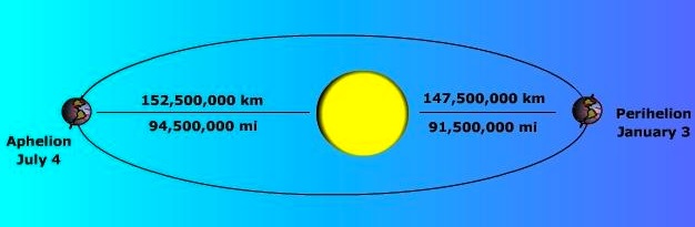
Earth revolves around the Sun once every 365 1/4 days. As illustrated in Figure \(\PageIndex{7}\), the elliptical orbit of the Earth varies from 91.5 million miles on January 3 called "perihelion", to 94.5 million miles on July 4 called "aphelion" for an average Earth-sun distance of 93 million miles. The elliptical path causes only small variations in the amount of solar radiation reaching the Earth.
The constant tilt and parallelism causes changes in the angle that a beam of light makes with respect to a point on Earth during the year, called the "sun angle". The most intense incoming solar radiation occurs where the sun's rays strike the Earth at the highest angle. During the summer months the Earth is inclined toward the Sun yielding high sun angles. During the winter, the Earth is oriented away from the Sun creating low sun angles.

Figure \(\PageIndex{9}\) is a simplified astronomy diagram shows the Sun at the center with four positions of Earth arranged around it along a circular orbital path. White arrows indicate the direction of Earth’s revolution around the Sun. At each position, Earth’s axis remains tilted in the same direction. The four labeled seasonal positions are:
- Vernal Equinox at the top of the orbit
- Summer Solstice on the left side
- Autumnal Equinox at the bottom
- Winter Solstice on the right side
The Sun is depicted as a glowing orange sphere against a black background. Each Earth is shown with visible continents and oceans, and the tilted axis is marked on every globe. The diagram illustrates how Earth’s tilt and revolution around the Sun produce the yearly cycle of seasons, with equinoxes marking equal day and night and solstices marking the longest and shortest days of the year.
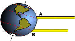
Figure \(\PageIndex{9}\) is a simple Earth–Sun geometry diagram shows Earth on the left with a slightly tilted axis and two parallel yellow bands representing incoming sunlight from the right. Two points on Earth's surface are labeled A (higher latitude) and B (lower latitude, closer to the equator). The sunlight rays intersect Earth at different angles, illustrating how solar energy is distributed unevenly across the planet. Point B receives more direct sunlight, while point A receives sunlight at a lower angle, spreading the same energy over a larger surface area. The diagram demonstrates why lower latitudes generally receive more intense solar heating than higher latitudes.