

1.3: Five Themes of Geography
- Page ID
- 40268
\( \newcommand{\vecs}[1]{\overset { \scriptstyle \rightharpoonup} {\mathbf{#1}} } \)
\( \newcommand{\vecd}[1]{\overset{-\!-\!\rightharpoonup}{\vphantom{a}\smash {#1}}} \)
\( \newcommand{\dsum}{\displaystyle\sum\limits} \)
\( \newcommand{\dint}{\displaystyle\int\limits} \)
\( \newcommand{\dlim}{\displaystyle\lim\limits} \)
\( \newcommand{\id}{\mathrm{id}}\) \( \newcommand{\Span}{\mathrm{span}}\)
( \newcommand{\kernel}{\mathrm{null}\,}\) \( \newcommand{\range}{\mathrm{range}\,}\)
\( \newcommand{\RealPart}{\mathrm{Re}}\) \( \newcommand{\ImaginaryPart}{\mathrm{Im}}\)
\( \newcommand{\Argument}{\mathrm{Arg}}\) \( \newcommand{\norm}[1]{\| #1 \|}\)
\( \newcommand{\inner}[2]{\langle #1, #2 \rangle}\)
\( \newcommand{\Span}{\mathrm{span}}\)
\( \newcommand{\id}{\mathrm{id}}\)
\( \newcommand{\Span}{\mathrm{span}}\)
\( \newcommand{\kernel}{\mathrm{null}\,}\)
\( \newcommand{\range}{\mathrm{range}\,}\)
\( \newcommand{\RealPart}{\mathrm{Re}}\)
\( \newcommand{\ImaginaryPart}{\mathrm{Im}}\)
\( \newcommand{\Argument}{\mathrm{Arg}}\)
\( \newcommand{\norm}[1]{\| #1 \|}\)
\( \newcommand{\inner}[2]{\langle #1, #2 \rangle}\)
\( \newcommand{\Span}{\mathrm{span}}\) \( \newcommand{\AA}{\unicode[.8,0]{x212B}}\)
\( \newcommand{\vectorA}[1]{\vec{#1}} % arrow\)
\( \newcommand{\vectorAt}[1]{\vec{\text{#1}}} % arrow\)
\( \newcommand{\vectorB}[1]{\overset { \scriptstyle \rightharpoonup} {\mathbf{#1}} } \)
\( \newcommand{\vectorC}[1]{\textbf{#1}} \)
\( \newcommand{\vectorD}[1]{\overrightarrow{#1}} \)
\( \newcommand{\vectorDt}[1]{\overrightarrow{\text{#1}}} \)
\( \newcommand{\vectE}[1]{\overset{-\!-\!\rightharpoonup}{\vphantom{a}\smash{\mathbf {#1}}}} \)
\( \newcommand{\vecs}[1]{\overset { \scriptstyle \rightharpoonup} {\mathbf{#1}} } \)
\(\newcommand{\longvect}{\overrightarrow}\)
\( \newcommand{\vecd}[1]{\overset{-\!-\!\rightharpoonup}{\vphantom{a}\smash {#1}}} \)
\(\newcommand{\ket}[1]{\left| #1 \right>}\)
\(\newcommand{\bra}[1]{\left< #1 \right|}\)
\(\newcommand{\braket}[2]{\left< #1 \vphantom{#2} \right| \left. #2 \vphantom{#1} \right>}\)
\(\newcommand{\braopket}[3]{\left< #1 \vphantom{#2}\vphantom{#3} \right| #2 \vphantom{#1}\vphantom{#3} \left| #3 \vphantom{#1}\vphantom{#2} \right>}\)
\(\newcommand{\qmvec}[1]{\mathbf{\vec{#1}}}\)
\(\newcommand{\op}[1]{\hat{\mathbf{#1}}}\)
\(\newcommand{\expect}[1]{\langle #1 \rangle}\)
\(\newcommand{\dfn}[1]{\emph{\textbf{#1}}}\)
The Nature of Geography
Since Geography focuses on a wide range of topics it is essential to outline five themes of Geography. Five Themes of Geography were developed in 1984 in a collaborative effort by the National Council for Geographic Education and the American Association of Geographers. The resulting publication was published in the 1984 Guidelines for Geographic Education : Elementary and Secondary Schools. This document was created to help school teachers organize geography curriculum.

Figure \(\PageIndex{1}\) presents the "Five Themes of Geography". Labels included in the flow chart:
- Location
- Relative Location: Describes a place in relation to other places.
- Absolute Location: Uses coordinates (latitude and longitude) or a specific address.
- Place
- Refers to the physical and human characteristics that define a location.
- Movement
- Explores how people, goods, and ideas move from one place to another.
- Human-Environment Interaction
- Examines how humans adapt to, modify, and depend on their environment.
- Region
- Formal Region: Defined by official boundaries or shared characteristics.
- Functional Region: Defined by a function, such as a metropolitan area.
- Vernacular Region: Based on people's perception, like "the South" or "the Midwest."
We will now look into each of these themes in detail.
Location
Location aims to answer the question "where?". It is the most fundamental question that is asked in geography. This theme of geography enables us to find a place on the Earth. There are 2 ways in which we provide the location of a place. The two methods are relative location and absolute location.
Absolute location offers a precise way to find a place using Latitudes and Longitudes, Street Address or Township and Range.
Latitudes and longitudes are imaginary lines drawn on the globe to enable us to find the location of a place. The Equator is the central most parallel of latitude drawn midway between the North Pole and South Pole. It divides the Earth into northern and southern hemisphere. There are 90 degrees to the north and 90 degrees to the south of the Equator. All the other parallels of latitude are mapped based on the distance from the equator. The meridians of longitudes are non parallel arcs drawn joining the North Pole and the South Pole. The Central most meridian of longitude is the Prime Meridian. All the other meridians of longitude are drawn with reference to the Prime Meridian. There are 180 degrees of meridian on either side of the Prime Meridian. The Prime Meridian and the 180 degree meridian together form a great circle dividing the Earth into eastern and western hemisphere. Thus, when we look at a location, we have a latitude and a longitude reading. The co-ordinates for the Eiffel Tower in Paris, France is 48.8584° N, 2.2945° E. The latitude and longitude for San Francisco, California is 37.7749° N, 122.4194° W.
Township and range divide a location into grids. As shown in Figure \(\PageIndex{2}\), townships are 6 mile squares that are measured south or north with reference to a base line labeled T1N (north) or T1S (south). Ranges are 6 mile squares measured east or west with reference to a central line named R1E (east) or R1W (west). As a result of this each township has 36 sections which are named in a snake like pattern starting from the north east section labeled section1. Las Vegas, Nevada, is located within the Public Land Survey System PLSS which is also known as the township and range system.
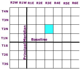
Figure \(\PageIndex{2}\) shows a square grid system divided into rows and columns. The grid is made of evenly spaced squares. A bold horizontal line and a bold vertical line intersect at the center, forming a cross that divides the plane into four quadrants. Across the top of the grid, columns are labeled in sequence. These labels indicate positions east (E) and west (W) of the principal meridian:
- R2W, R1W (to the left of the vertical axis)
- R1E, R2E, R3E, R4E, R5E, R6E (to the right of the vertical axis)
Along the left side of the grid, rows are labeled. These labels indicate positions north (N) and south (S) of the baseline.
- T4N, T3N, T2N, T1N (above the baseline)
- T1S, T2S, T3S (below the baseline)
- Vertical Axis
- The vertical bold line is labeled “Principal Meridian.”
- This axis divides the grid into an east side (right) and a west side (left).
- Horizontal Axis
- The horizontal bold line is labeled “Baseline.”
- This axis divides the grid into a north section (above) and a south section (below).
- The highlighted square is located: In row T2N (two units north of the baseline)In column R2E (two units east of the principal meridian).
Street addresses are another way in which we can find the absolute location of a place. 600 Montgomery St, San Francisco, CA 94111, United States is the street address for The Transamerica Pyramid in San Francisco, California. It is a fixed point on the Earth and unless there is some renumbering due to some redevelopment, the street address uniquely identifies a location. Applying modern technology like GIS such street addresses can be converted into latitude and longitude co-ordinates.
Relative location is when we provide a description of the location of a place in relation to its environment. San Francisco is located to the west of Oakland. In order to figure out where San Francisco is located we need to know about its environment. In this case we need to know where Oakland is located in order to figure out where San Francisco is. We can also say the city of San Francisco is 12.3 miles to the north of San Francisco International Airport.
Place
Place provides more information about a location in terms of physical and human characteristics.
Physical characteristics include description of physical features like mountains, plateaus, rivers, beaches, topography, climate, flora and fauna of the location. San Francisco would be described as a pleasant weather beach front city. This creates an image of the location based on its physical descriptors.
Human characteristics include the cultural features of a place that have been created by humans. Such features include but are not restricted to land use, architecture, livelihood, religion, politics, transport and communication. When we talk about the presence of the Golden Gate Bridge, The Transamerica Pyramid in the San Francisco skyline we are referring to the human characteristics of the place.
Movement
When we look at movement as a theme of geography we not only mean movement of people but we also mean movement of goods, ideas, services, technology, money, resources and communication. This theme studies movement and migration. In geography, movement is a broad term involving any change of location, migration involves movement with a more permanent change of residence. When international students come into United States of America, they bring with them their money, culture, their thoughts , their ideas. They not only influence their friends but also get influenced by them. Emigration of a population during a natural disaster like volcanic eruption, flow of Gulf stream Ocean Currents and expansion of cellphone coverage across the world are all examples of movement.
Human-Nature Interaction
In order to continue with day to day activities humans either adapt to their immediate environment or try to change their environment to suit them better. Such interactions with the environment are called human-nature interactions. This theme looks at how humans adapt to and modify their environment. Humans can positively or negatively impact the landscape around them as they modify it to suit their needs. Human excavation for resources may sometimes lead to landslides. This theme looks at humans cutting trees or mining coal to warm themselves in places where the weather is cold. In Norway hydraulic dikes are used for protection from floods and for reclamation of land.
Region
Regions divide the world into units for study based on a unifying criteria. All regions are different from the next one based on this unifying criteria. The regions will also have a user defined boundary separating them from the next region. Regions can also vary in scale. There can be three types of regions: formal, functional and vernacular.
Formal regions are sometimes characterized by official boundaries such as cities, states, counties, and countries. For the most part, they are clearly indicated and publicly known. State of California would be an example of a formal region. Regionalization based on type of vegetation, climate all fall under this category.
Functional regions are characterized by a central business district and a hinterland. Here the regions are unified based on the function they perform. Here there is a node and a surrounding area which is connected to the node based on their interactions. As we move away from the node, the influence of the node tends to decrease. For example San Francisco and the Bay area. San Francisco and the Bay area are connected by their needs and wants. San Francisco markets need fruits and vegetables. The population in the Bay Area need jobs, there are companies in San Francisco that provide those jobs. Newspaper circulation area, Pizza delivery zones, Transportation networks are all examples of functional regions.
Vernacular regions are regions where regionalization is done based on the perceived history of the place. It primarily exists in the mind of people based on common interests, cultural characteristics or shared identity. These regions have subjective boundaries that may vary from person to person. These regions are shaped by people's beliefs, experiences, and understanding of the world. They can evolve over time as cultural practices or perceptions may change. The Silicon Valley in California is such a region which is known as a technology hub with a concentration of tech companies and a specific industry culture. The Midwest in United States of America is another such example.