4.5: Some Practical Things About Water Wells
- Page ID
- 13472

A great many households in rural or semi-rural areas depend upon wells for their water supply. In earlier times, shallow wells were dug by hand to depths of a few tens of feet. In more recent times, wells have been driven by various techniques to much greater depths of many hundreds of feet to tap deeper groundwater. Most such driven wells are lined with a jacket or casing that’s porous in the lower part of the well. This casing keeps the walls from collapsing or crumbling inward, without inhibiting the water flow. This section presents some aspects of the flow of water in the immediate vicinity of wells.
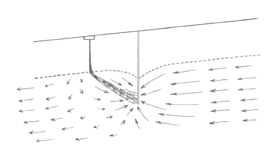
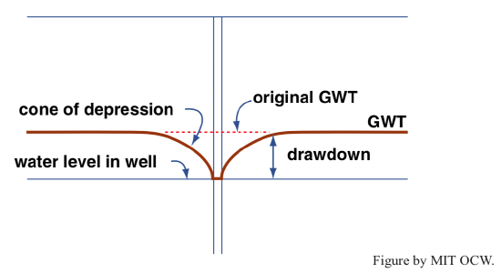
The first thing to keep in mind is that the removal of water through a well disrupts the normal or background flow of groundwater in the vicinity by producing a locally lower water pressure in the lower part of the well. The relatively strong pressure gradients near the well cause a flow of water radially inward toward the well. The difference in elevation between the depressed water level in the operating well and the elevation the water table would have if water were not being drawn from the well is called the drawdown of the well (Figure 4-22). The locally cone-shaped surface of the water table in the vicinity of the well is called the cone of depression. In areas with closely spaced wells, the cones of depression of the wells may interfere with one another to produce a general lowering of the water table in the area (Figure 4-23).
Your well becomes polluted from an upstream pollution source only if its intake lies in the path taken by the pollutant. A pollutant introduced at a point source reaches the groundwater table by downward percolation and then travels with the groundwater flow as a plume, narrow at first but gradually widening because of slow lateral diffusion (Figure 4-24). (A plume is a mass of fluid that moves through ambient fluid, as a consequence of a difference in density or just because that fluid is injected, over some period of time, into the flowing ambient fluid at a point, as is the case here. A good example of a plume of the former kind is smoke that rises out of a chimney or a smokestack.)
A well upslope of the point of pollutant injection can tap a pollutant plume, if the distortion of the natural flow pattern is so great as to produce locally upslope flow toward the well. The situation shown in Figure 4-25, in which all of the pollutant plume is drawn up by the well, is an extreme example.
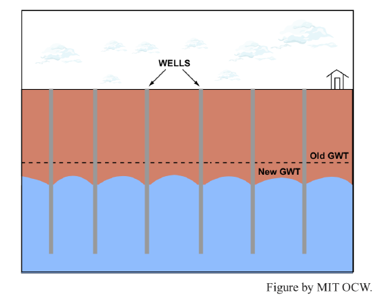
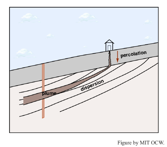
Figure 4-24. A well lying in the path of a pollutant plume.
If in the long term one or more wells in a given area remove water faster than it can be supplied by recharge by percolation from surface rainfall, the water table is lowered. In areas with shallow wells and abundant recharge, where natural flow rates are high, the water table responds rapidly, in hours or days. But in areas with deep wells and slow recharge, the depressed water table might take many years or even decades to readjust, even if no water at all is drawn from the wells. In a very real sense, groundwater is being mined by these wells, because recharge is on a time scale much longer than the lifetime of the wells. This is the case today in many areas of the arid and semiarid central and western parts of the United States.