
Tides and Tidal Flats
- Page ID
- 10874
Introduction
The vertical rise and fall of the tides, created by the gravitational force of the Moon and Sun acting on the oceans water, also creates a horizontal motion of the water in the bays, harbors and estuaries. These are tidal currents. The tidal range of a particular location is dependent less on it position north/south of the equator than on other physical factors in the area; topography, water depth, shoreline configuration, size of the ocean basin, and others [1]. For more information on Tides and Shallow Subtidal Environments, see this page.
Shorelines that are influenced by strong daily tidal currents are called tidal mudflat depositional environments. Tides are currents that are the result of the gravitational forces exerted by the moon and the rotation of the earth. Shorelines that have strong tidal currents as well as seafloors with low gradients can have large areas that are submerged during high tide and exposed to air during low tide. These areas often have smaller particles than a normal shoreline since the tidal currents can pull marine sediments into the area. In addition, the strong bidirectional currents, daily drying out, exposure to the elements, and abundant life create abundant indicators of these environments [4].
Mudflats (tidal flats) are areas in which coastline shores are separated from the destructive forces of the ocean’s waves. [2]. Tidal flats, also known as mudflats, are flooded at high tide and exposed at low tide [3].
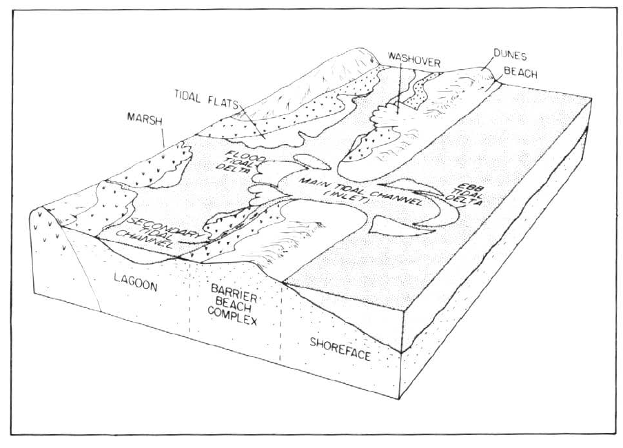
Figure 1: Location of tidal flats compared to other coastal depositional environments. This figure diagram locations across the barrier island topography from Reinson, G. E. (1979) [source]
Characteristics of Transport and Deposition
Figure 2 shows a cross section of the tidal flat environment and the lateral relationship of grain size. As shown in the figure, large sized grains are found seaward and there is a fining in grain size as you move inland. The King Sound area shows a change from sand to sand/mud to mud.
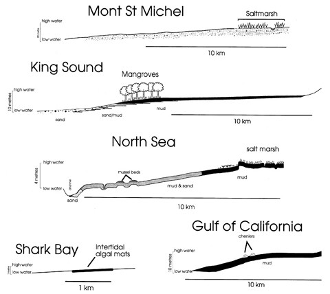
Figure 2: Cross sections of example tidal flat environments
Lateral environments
Part of the coast emergent during low tide and submerged during high tide is the intertidal zone. That part of the coast permanently submerged below the low-water line is the subtidal zone. That occurring above the zone of high-tide inundation is the supratidal zone [8]
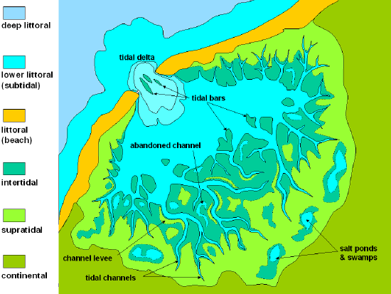
Figure 3: The lateral relationship of depositional environments from the ocean (top left) to inland salt ponds and swamps (bottom right)
Grain Size
Fine sediment is brought in during high tide and deposited as the tide turns. Tidal flats also have high deposition rates [3].
Common grain size of sediment in tidal flats is silt and clay [6]. Tidal flats may be muddy, sandy, gravelly, or covered in shell pavements, and compositionally they may be underlain by siliciclastic or carbonate sediments. The sediments commonly contain both siliciclastic and carbonate particles [8].
If there is sand and mud on the tidal flat, tidal and wave processes result in a partitioning of particle sizes: generally, sand dominates the low tidal flats, mixed sand and mud occur on mid-tidal flats, and mud on the high tidal flats. [8]
Sedimentary structures
Mudflats form when silt and mud are brought in by seas, oceans, and tributaries. The mud and the silt are deposited into bays and lagoons when the tide comes in. The water mixes with the mud and silt, creating the muddy quicksand that occurs in mudflats. Once the tide lowers, the mudflats are exposed along with what inhabits them [7].
During the event of a high tide, sea water level rises to engulf the entire area bringing in nutrients from the oceans. As the sea water extracts during the low tide, a vast amount of nutrient is left behind making the mudflat a rich feeding ground for a plethora of organisms that it hosts. The abundance of nutrients make mudflats one of the world’s most productive ecosystems, and as such, produces one of the most diversified range of living organisms. [2] The rich ecosystem provided by the tidal flats makes the area very active and will commonly contain evidence of bioturbation [3].
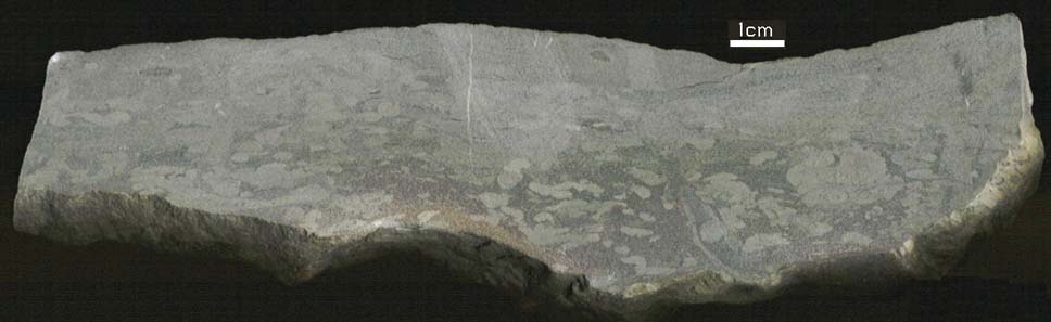
Figure 4: An example of bioturbation in a rock (the lighter tube-like features)
Root structures can also be present in tidal flats [8].
Herringbone cross stratification can be present because, due to changing flow directions, two sediment transport directions are common; one for onshore flow and one for offshore flow. This gives rise to current ripples showing transport in two directions and dune migration in two directions [source].
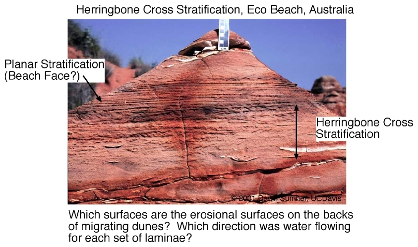
Figure 5: An example of herringbone cross stratification
Mudcracks form when a shallow body of water (e.g., a tidal flat or pond or even a puddle), into which muddy sediments have been deposited, dries up and cracks. This happens because the clay in the upper mud layer tends to shrink on drying, and so it cracks because it occupies less space when it is dry. [source]
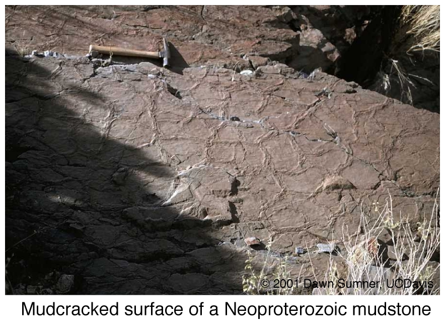
Figure 6: An example of mudcracks
Muddrapes: During slack tides (low or especially high), fine grained sediment can fall out of suspension draping tidal bedforms with mud. Because mud is cohesive, it does not necessarily erode during the next tidal flow, particularly in the separation zone where flow is slow, e.g. at the bases of ripples and dunes. [source]
As the land slopes down on the side of the island facing the mainland, the low-lying areas transition into a salt marsh or mud flat habitat, which is protected from wave action, but is influenced by tidal changes. The mud flats are colonized by grasses, which slow down the movement of water and lead to increased sediment deposition, building up the land in the marsh. Different species of grasses eventually dominate the different elevations of the salt marsh, depending on their tolerance for submersion in seawater. These salt marshes are very important habitats for many invertebrates, birds, and juvenile fish. [5]
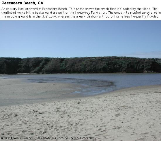
Figure 7: Tidal flat shown here on the left.
Vertical Facies
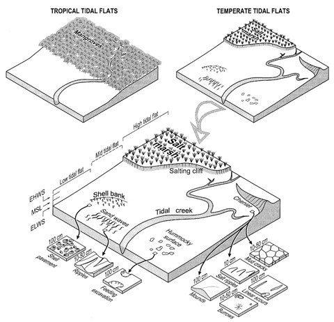
Figure 8: Geomorphology of tidal flats.
For stratigraphers and students of sedimentary rocks, identifying tidal flats in the geologic record is often an important step in the reconstruction of paleoenvironments, the location of facies associated with coastlines, and the recognition of such markers in stratigraphic sequences in basin analyses [8].
- Strat column and describe expected sequence vertically
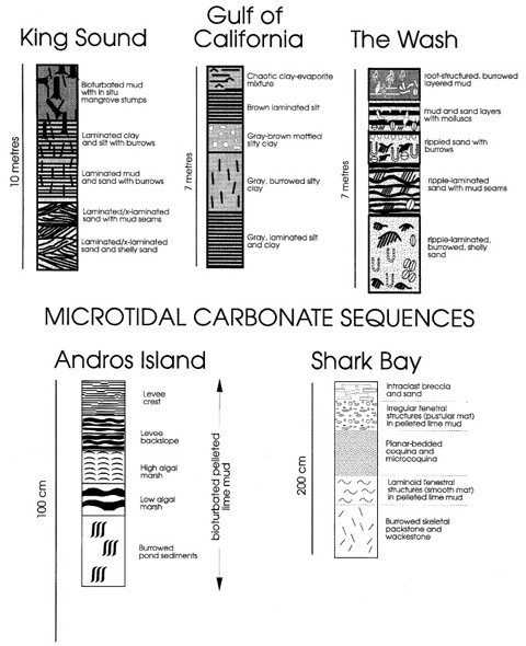
Figure 9: An example of stratigraphic columns in tidal flat environments.
Summary
Common grain size includes multiple different grain sizes, including sand, silt, and clay particles. The main common sedimentary structures are bioturbation, herringbone cross stratification, and mudcracks. Sediment accumulates during high tide and is deposited as the tide recedes.
Key Words
- Tidal flats
- Mud flats
- Bioturbation
References
https://link.springer.com/referenceworkentry/10.1007/1-4020-3880-1_19
Bookshelves/Geology/Book:_An_Introduction_to_Geology_(Johnson,_Affolter,_Inkenbrandt,_and_Mosher)/05:_Weathering,_Erosion,_and_Sedimentary_Rocks/5.05:_Depositional_Environments