
14.1: Introduction
- Page ID
- 12943
Module 14
Mass Wasting and Glaciers
Introduction
Landslides
Landslides constitute a major geologic hazard because they are widespread, occur in all 50 states and U.S. territories, and cause $1-2 billion in damages and more than 25 fatalities on average each year. Expansion of urban and recreational developments into hillside areas leads to more people that are threatened by landslides each year. Landslides commonly occur in connection with other major natural disasters such as earthquakes, volcanoes, wildfires, and floods.
The term landslide includes a wide range of ground movement, such as rock falls, deep failure of slopes, and shallow debris flows. Although gravity acting on an over-steepened slope is the primary reason for a landslide, there are other contributing factors:
- Erosion by rivers, glaciers, or ocean waves create over-steepened slopes.
- Rock and soil slopes are weakened through saturation by snowmelt or heavy rains.
- Earthquakes create stresses that make weak slopes fail.
- Earthquakes of magnitude 4.0 and greater have been known to trigger landslides.
- Volcanic eruptions produce loose ash deposits, heavy rain, and debris flows.
- Excess weight from accumulation of rain or snow, stockpiling of rock or ore, from waste piles, or from man-made structures may stress weak slopes to failure.
Slope material that become saturated with water may develop a debris flow or mud flow. The resulting slurry of rock and mud may pick up trees, houses, and cars, thus blocking bridges and tributaries causing flooding along its path.
Landslide Locations
Landslides occur in every state and U.S. territory. The Appalachian Mountains, the Rocky Mountains and the Pacific Coastal Ranges and some parts of Alaska and Hawaii have severe landslide problems. Any area composed of very weak or fractured materials resting on a steep slope can and will likely experience landslides.
Although the physical cause of many landslides cannot be removed, geologic investigations, good engineering practices, and effective enforcement of land-use management regulations can reduce landslide hazards.
– Excerpts from “Landslides 101,” Landslide Hazards Program, U.S. Geological Survey
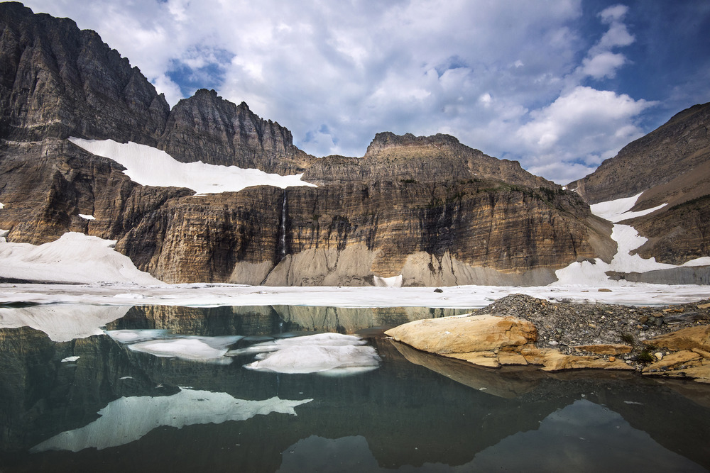
Glaciers in Glacier National Park. Montana, USA
A glacier is a body of snow and ice of sufficient size and mass to move under its own weight. Glacier movement may be detected by the presence of crevasses, or cracks that form in the ice as the glacier moves. In Glacier National Park (GNP), USGS scientists define glaciers according to the commonly accepted guideline in which a body of ice has an area of at least 0 .1 km2 (100,000 m2), or about 25 acres. Below this size, the ice is generally stagnant and does not move, unless it is on a steep slope. Glaciers are dynamic, changing in response to temperature and precipitation. A glacier forms when winter snowfall exceeds summer melting. Glaciers retreat when melting outpaces accumulation of snow.
While the glaciers that carved GNP’s majestic peaks were part of a glaciation that ended about 12,000 years ago, the relatively small alpine glaciers that cling to mountainsides today are considered geologically new, having formed about 7,000 thousand years ago. These glaciers grew substantially during the Little Ice Age (LIA) that began around 1400 AD and reached their maximum size at the end of the LIA around 1850 AD. Their maximum sizes can be inferred from the mounds of rock and soil left behind, known as moraines. Aerial photography reveals moraines of over 150 glaciers that existed in Glacier National park at the end of the LIA. In 2015, only 26 active named glaciers remain.
Early park visitors and scientists noted that glaciers were retreating as early as 1914. The climate was already warming and glaciers were responding, but the industrial revolution added more carbon dioxide to the atmosphere, furthering glacier retreat. In Glacier National Park, as well as around the globe, glacier mass and extent has decreased during the 20th century in response to warmer temperatures.
– Excerpts from “Retreat of Glaciers in Glacier National Park,” Northern Rocky Mountain Science Center, U.S. Geological Survey
Select an image to view larger


Module Objectives
At the completion of this module you will be able to:
- Explain how slope stability is related to slope angle, and how various factors influence the strength of materials on slopes.
- Explain what types of events can trigger mass wasting, and the types of motion that can happen during mass wasting.
- Describe the main types of mass wasting, the steps we can take to delay it, and some of the measures that can be taken to mitigate the risks associated with mass wasting.
- Describe the timing and extent of Earth’s past glaciations and the important geological events that led up to the Pleistocene glaciations.
- Explain the differences between continental and alpine glaciation.
- Identify the various landforms related to alpine glacial erosion, and various types of glacial lakes.
Activities Overview
See the Schedule of Work for dates of availability and due dates.
Be sure to read through the directions for all of this module’s activities before getting started so that you can plan your time accordingly. You are expected to work on this course throughout the week.
Module 14 Assignment: A Virtual Field Trip Guide to Exploring the Volcanic History and Evidence of Mass Wasting at Sentinel Peak, Tucson, Arizona
20 points
After you complete the reading, you can start working on Module 14 Assignment – A Virtual Field Trip Guide to Exploring the Volcanic History and Evidence of Mass Wasting at Sentinel Peak, Tucson, Arizona
Discussion 5 – Climate Change
30 points (+5 points extra credit)
This week’s discussion guidelines are different from the previous discussions. We will be having a conversation about climate change and the ways in it which it might personally affect you or your family.
Check the Schedule of Work for Due Date.
Module 14 Quiz
10 points
Module 14 Quiz has 10 multiple-choice questions and is based on the content of the Module 14 readings and assignment.
The quiz is worth a total of 10 points (1 points per question). You will have only 10 minutes to complete the quiz, and you may take this quiz only once. Note: that is not enough time to look up the answers!
Make sure that you fully understand all of the concepts presented and study for this quiz as though it were going to be proctored in a classroom, or you will likely find yourself running out of time.
Keep track of the time, and be sure to look over your full quiz results after you have submitted it for a grade.
Your Questions and Concerns…
Please contact me if you have any questions or concerns.
General course questions: If your question is of a general nature such that other students would benefit from the answer, then go to the discussions area and post it as a question thread in the “General course questions” discussion area.
Personal questions: If your question is personal, (e.g. regarding my comments to you specifically), then send me an email from within this course.
- Module 14: Mass Wasting and Glaciers. Authored by: Anne Huth. Provided by: Pima Community College. Located at: http://cc.pima.edu/~lumen/glg101/module%20parts%20-%20LUMEN/Module14/L_Mod14.html. License: CC BY: Attribution
- Physical Geology, Adapted by Anne Huth, Pima Community College. Authored by: Steven Earle. Located at: https://opentextbc.ca/geology/. License: CC BY: Attribution
- Laboratory Manual for Introductory Geology, Adapted by Anne Huth, Pima Community College. Authored by: Bradley Deline, Randa Harris, and Karen Defend. Located at: https://open.umn.edu/opentextbooks/BookDetail.aspx?bookId=506. License: CC BY: Attribution
- Figure 6: Solifluction, by Anne Bugess for geograph.com. Provided by: Wikimedia Commons. Located at: https://commons.wikimedia.org/wiki/File:Solifluction_-_geograph.org.uk_-_475616.jpg. License: CC BY-SA: Attribution-ShareAlike
- Figure 7: Oberaargletscher from Oberaar. Authored by: Ximonic. Provided by: Wikimedia Commons. Located at: https://commons.wikimedia.org/wiki/File:Oberaargletscher_from_Oberaar,_2010_07.JPG. License: CC BY-SA: Attribution-ShareAlike
- Figure 8: Exit Glacier, Alaska. Authored by: Dubhe. Provided by: Wikimedia Commons. Located at: https://commons.wikimedia.org/wiki/File:1055_-_exit_glacier.jpg. License: CC BY-SA: Attribution-ShareAlike
- Figure 1: Grinnell Glacier Basin. Authored by: RTim Rains. Provided by: National Park Service. Located at: https://www.nps.gov/media/photo/gallery-item.htm?pg=0&id=34F574D2-1DD8-B71B-0BDE3EA69DD198E8&gid=349C0EDC-1DD8-B71B-0B7F5C7870E5BE6F. License: Public Domain: No Known Copyright
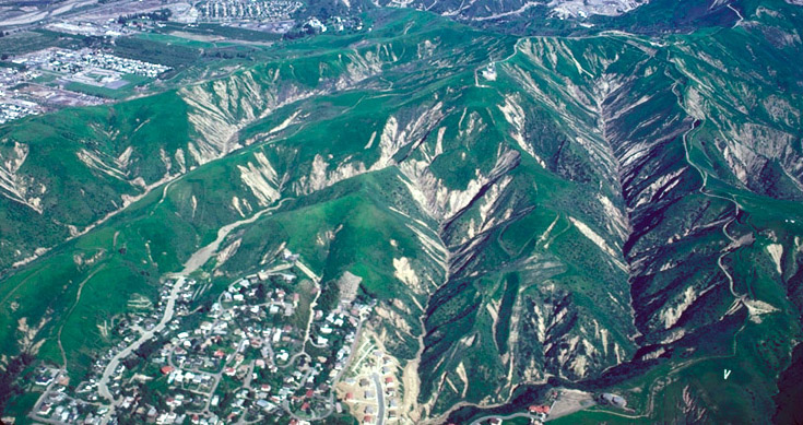
- Figure 2: Debris flow scars formed in 1968-1969 in greater Los Angeles. Authored by: USGS. Provided by: Wikimedia Commons. Located at: https://commons.wikimedia.org/wiki/File:Debris_flow_scars.jpg. License: Public Domain: No Known Copyright
- Figure 3: Oso mudslide. Authored by: Spc Matthew Sissel/Spc. Samantha Ciaramitaro for Army National Guard. Provided by: Wikimedia Commons. Located at: https://commons.wikimedia.org/wiki/File:Oso_Mudslide_29_March_2014_aerial_view_2.jpg. License: Public Domain: No Known Copyright
- Figure 4: Aftermath from the 2005 Laguna Beach Landslide. Authored by: USGS. Provided by: Flickr. Located at: https://www.flickr.com/photos/usgeologicalsurvey/23144152045. License: Public Domain: No Known Copyright
- Figure 5: Talus slopes/cones on the north shore of Isfjordan, Svalbard, Norway.. Authored by: Wilson44691. Provided by: Wikimedia Commons. Located at: https://commons.wikimedia.org/wiki/File:TalusConesIsfjorden.jpg. License: Public Domain: No Known Copyright
- Figure 9: Fox Glacier in New Zealand. Authored by: Mjobling. Provided by: Wikimedia Commons. Located at: https://commons.wikimedia.org/wiki/File:Fox_Glacier_NZ_2.jpg. License: Public Domain: No Known Copyright