
12.2: Shoreline Features
- Page ID
- 11274

Many different erosional and depositional features exist in the high energy of the coast. The coast or coastline includes all parts of the land-sea boundary area that are directly affected by the sea. This includes land far above high tide and well below normal wave base. But the shore or shoreline itself is the direct interface between water and land that migrates with the tides and with deposition and erosion of sediment. Processes at the shoreline are called littoral processes.
Shoreline Zones
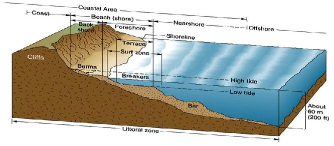
Shoreline zones can be viewed by looking at the beach profile, which is divided into four primary zones – offshore, nearshore, foreshore, and backshore. The offshore is below any shoreline-derived process but is still geologically active due to cascading sands of turbidites and deeper currents (with deposits called contourites). The nearshore is affected by the waves, i.e., that part of the shore where water depth is a half wavelength or less. The width of this zone thus depends on the maximum wavelength of the approaching wave train and with the slope of the seafloor. The nearshore area, when looking at rocks deposited in this zone, is typically called the shoreface, and is broken into two segments: upper shoreface, which is affected by everyday wave action, typically consisting of finely-laminated and cross-bedded sand, and lower shoreface, the area only moved by storm waves, which has hummocky cross-stratified sand. The surf zone is where the waves break. The area (mostly overlapping the surf zone) that is periodically wet and dry, because of wave action and tides, is called the foreshore, which is made of planer-laminated, well-sorted sand.
The beach face is where the swash of the breaking wave runs up and the backwash flows back down. Above the beach face are low ridges called berms. During the summer in North America, when most people visit the beach, the zone of footprints and beach umbrellas is the summer berm. Wave energy is typically lower in the summer, which allows sand to be piled onto the beach. Behind the summer berm is commonly a low ridge of sand representing the winter berm. Beachgoers walk across this winter berm from the parking lot to the summer berm where they park their items. Higher winter storm energy moves the summer berm sand off the beach and piles it in the near from which it will be replaced next year as it is moved back onto the summer berm. There may be a zone of dunes behind the berms representing sand blown behind the beach by onshore winds. This area behind the berms that is always above the ocean in normal conditions is known as the backshore. Shorelines are actually simplified for this discussion; they are a dynamic and geologically-complicated place.
Refraction, Longshore Currents, and Longshore Drift
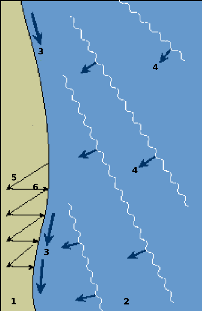
As waves enter shallower water, they slow down. Waves usually approach the shoreline at an angle, with one end of the waves of the train slowing down first. This causes the waves to bend toward the beach. Such bending of the waves as they enter shallower water is called wave refraction, which produces the appearance from the beach that waves are approaching the beach face generally straight on, parallel to the beach. However, refracted waves on average approach the shoreline at somewhat of an angle creating a slight difference between the swash as it moves up the beach face and the backwash as it flows back down. This results in a net movement of the water along the beach creating a current called the longshore current. Sand stirred up by waves in the surf zone is thus moved along the shore by longshore drift. Longshore drift along both the west and east coasts of North America moves sand on average from north to south.
 [Public domain], <a data-cke-saved-href=\"https://commons.wikimedia.org/wiki/File%3AFarewell_Spit.jpg\" href=\"https://commons.wikimedia.org/wiki/File%3AFarewell_Spit.jpg\"") via Wikimedia Commons" width="373px" height="240px" src="/@api/deki/files/7983/FarewellSpitNZ-300x193.jpg">
via Wikimedia Commons" width="373px" height="240px" src="/@api/deki/files/7983/FarewellSpitNZ-300x193.jpg">Longshore drift can be carried down the coast until it reaches a bay or inlet where it begins to deposit in the quieter water. Here, a spit begins to form. As the spit grows, it may extend across the mouth of the bay forming a baymouth bar. Where the bay or inlet serves as the anchorage for boats, such spit growth and baymouth bars are a severe inconvenience. Communities thus affected attempt measures to keep their harbor open.

One means to do this is a jetty, often built of concrete or large stones, forming a long barrier to deflect the sand away from the harbor mouth or other ocean waterways in which transport is desired. If the jetty does not succeed in deflecting the sand far enough out, it may continue to flow along the shore, building a spit around the end of the jetty. A more expensive but effective method is then to dredge the sand from the growing spit, put it on barges, and deliver it back to the drift downstream of the harbor opening. An even more expensive (but effective) means is to install large pumps and pipes to draw in the sand upstream of the harbor, pump it through pipes, and discharge it back into the drift downstream of the harbor mouth. Because natural processes are at work continuously, human efforts to mitigate inconveniences are sometimes not equal to the task or require ongoing modifications. The community of Santa Barbara, California, tried several methods to keep their harbor open before settling on pumps and piping [2].
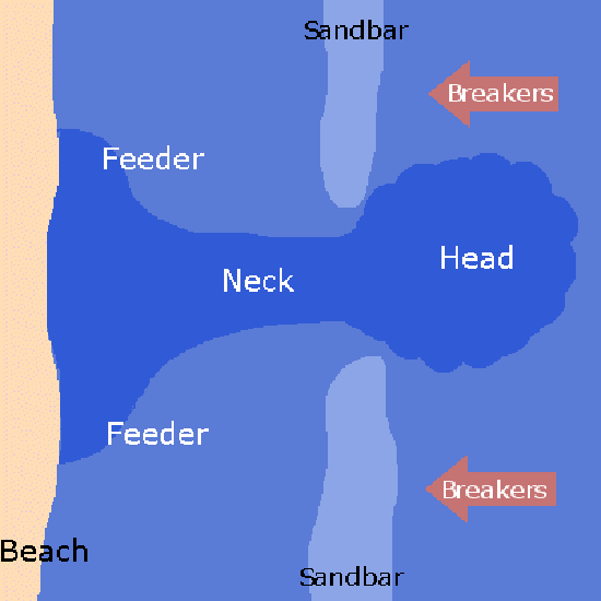
Another coastal phenomenon related to longshore currents is the presence of rip currents. These involve the nearshore configuration of the seafloor and/or the arrival of wave trains straight onto the shore. In areas where wave motion pushes water directly toward the beach face, or the shape of the nearshore seafloor refracts and focuses the water movement toward a point on the beach, the water piling up there must find an outlet back to the sea. The outlet is provided by relatively narrow rip currents that carry the water directly away from the beach. Swimmers caught in such currents find themselves being carried out to sea. They may attempt to return to shore by swimming directly against the current. This is generally a fruitless effort because they tire against the strong current. A better solution is to ride it out to where it dissipates, then swim around it and return to the beach or swim laterally, parallel to the beach, until out of the current, then return to the beach. Awareness of the presence of rip currents with a plan is the key or avoid them altogether.
Emergent and Submergent Coasts
 CC BY-SA 3.0 or GFDL], via Wikimedia Commons" width="393px" height="139px" src="/@api/deki/files/7989/Island_Archway_Great_Ocean_Rd_Victoria_Australia_-_Nov_08-300x106.jpg">
Coastlines that have a relative fall in sea level, either caused by tectonics or sea level change, are called emergent. Where the shoreline is rocky, perhaps with a sea cliff, waves refracting around headlands attack the rocks behind the point of the headland.
 [<a data-cke-saved-href=\"http://www.gnu.org/copyleft/fdl.html\" href=\"http://www.gnu.org/copyleft/fdl.html\"") GFDL, CC-BY-SA-3.0 or CC BY 2.5], via Wikimedia Commons" width="300" src="/@api/deki/files/7988/Angel_Road_Shodo_Island_Japan01s3-300x200.jpg">
GFDL, CC-BY-SA-3.0 or CC BY 2.5], via Wikimedia Commons" width="300" src="/@api/deki/files/7988/Angel_Road_Shodo_Island_Japan01s3-300x200.jpg">They may cut out the rock at the base forming a sea arch which may collapse to isolate the point as a stack. Rocks behind the stack may be eroded away and sand eroded from the point collects behind it forming a tombolo, a sand strip that connects the stack to the shoreline. Where sand supply is low, wave energy may erode a wave-cut platform across the surf zone, exposed as a bare rock with tidal pools at low tide. Wave energy expended at the base of a sea cliff may cut a wave notch.
 via Wikimedia Commons" width="359px" height="124px" src="/@api/deki/files/7990/WaveCutPlatformsAntelopeIslandUT-300x104.jpg">
Sea cliffs tend to be persistent features as the waves cut away at their base and higher rocks calve off by mass wasting. If the coast is emergent, these erosional features may be elevated relative to the wave zone. Wave-cut platforms become marine terraces, perhaps with remnant sea cliffs inland from them.
 via Wikimedia Commons" width="372px" height="278px" src="/@api/deki/files/7991/Chesapeakelandsat-300x225.jpeg">
Tectonic subsidence or sea level rise produces a submergent coast. Features associated with the submergent coasts include estuaries, bays and river mouths flooded by the higher water. Fjords are former glacial valleys now flooded by post-Ice Age sea level rise (see chapter 14). Elongated bodies of sand called barrier islands form parallel to the shoreline from the old beach sands, often isolated from the mainland by lagoons behind them [3]. The formation of barrier islands is controversial; some workers believe as above that barrier islands were formed by rising sea level as the ice sheets melted after the last ice age. Accumulation of spits and far offshore bar formations are also mentioned as possible formation hypotheses for barrier islands.
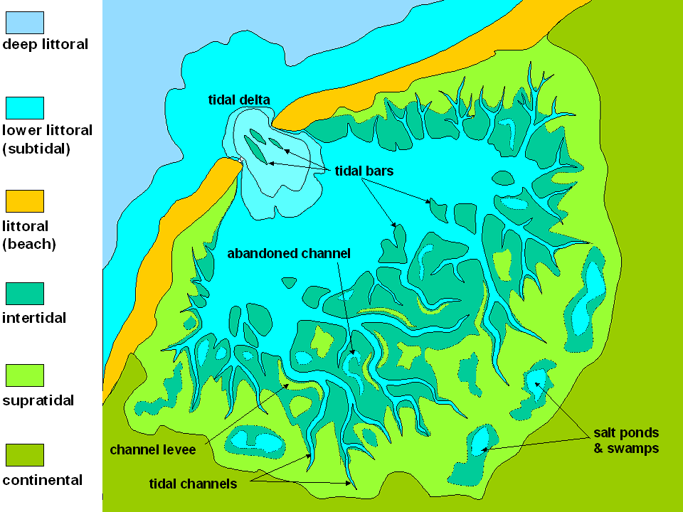
Tidal flats or mudflats form where tides alternately flood and expose low areas along the coast. Combinations of symmetrical ripple marks, asymmetrical ripple marks from tidal currents, and mud cracks from drying form on these flats. An example of ancient tidal flat deposits is exposed in the Precambrian strata found in the central part of the Wasatch Mountains of Utah. These ancient deposits provide an example of applying Hutton’s Uniformity Principle. The presence of features common on modern tidal flats prompts the interpretation that these ancient deposits were formed in a similar environment. There were shorelines, tides, and shoreline processes acting at that time, yet the age of the ancient rocks indicates that there were no land plants to hold products of mechanical weathering in place so rates of erosion would have been different. The Uniformity Principle must be applied with some knowledge of the context of the application.
Typically tidal flats are broken into three different sections, which may be abundant or absent in each individual tidal flat. Barren zones are areas with strong, flowing water and coarser sediment, with ripples and cross-bedding common. Marshes are vegetated with common sand and mud. Salt pans are the finest-grained parts of the tidal flats, with silty sediment, mud cracks, and are less often submerged [4].

Lagoons are locations where spits, barrier islands, or other features have partially cut off a body of water from the ocean. Estuaries are a (typically vegetated) type of lagoon where freshwater is flowing into the area as well, making the water brackish (between salt and freshwater). However, terms like a lagoon, estuary, and even bay are often loosely used in place of one another [5]. Lagoons and estuaries are certainly transitional between terrestrial and marine geologic environments, where littoral, lacustrine, and fluvial processes can overlap.
Human Impact on Coastal Beaches
 [<a data-cke-saved-href=\"http://creativecommons.org/licenses/by-sa/3.0\" href=\"http://creativecommons.org/licenses/by-sa/3.0\"") CC BY-SA 3.0], via Wikimedia Commons" width="321px" height="257px" src="/@api/deki/files/7993/Groin_effect-300x240.jpg">
CC BY-SA 3.0], via Wikimedia Commons" width="321px" height="257px" src="/@api/deki/files/7993/Groin_effect-300x240.jpg">Coasts are prime real estate land that attracts the development of beach houses, condominiums, and hotels. This kind of interest and investment leads to ongoing efforts to manage the natural processes in coastal areas. Humans who find longshore drift is removing sand from their beaches often use groins (also spelled groyne) in an attempt to retain it.
Similar but smaller than jetties, groins are bits of wood or concrete built across the beach perpendicular to the shoreline at the downstream end of one’s property. Unlike jetties, they are used to preserve sand on a beach, rather than to divert it from an area. Sand erodes on the downstream side of the groin and collects against the upstream side. Every groin thus creates the need for another one downstream. The series of groins along a beach develops a scalloped appearance for the shoreline.
Sand for longshore drift and beaches comes from rivers flowing to the oceans from inland areas. Beaches may become starved of sand if sediment carried by streams and rivers is trapped behind dams. To mitigate this, beach replenishment may be employed where sand is hauled in from other areas by trucks or barges and dumped on the depleted beach. Unfortunately, this can disrupt the ecosystem that exists along the shoreline by exposing native creatures to foreign sandy material and foreign microorganisms and can even bring in foreign objects that impact humans on replenished beaches. Visitors to one replenished east coast beach found munitions and metal shards in the sand which had been brought from abandoned test ranges from which the sand had been dredged [6].
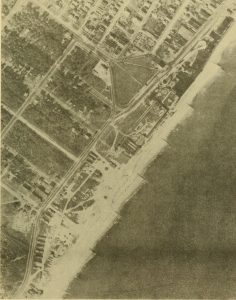
 No restrictions], via Wikimedia Commons" width="240px" height="264px" src="/@api/deki/files/8001/Venice_CA_breakwater_Bulletin_of_the_Beach_Erosion_Board_1948_20255015848-cropped-273x300.jpg">
Another approach to reduce erosion or provide protected areas for boat anchoring is the construction of a breakwater, an offshore structure against which the waves break, leaving calmer waters behind it. Unfortunately, this means that waves can no longer reach the beach to keep the longshore drift of sand moving. The drift is interrupted, the sand is deposited in the quieter water, and the shoreline builds out forming a tombolo behind the breakwater, eventually covering the structure with sand [7]. The image shows this result at the breakwater constructed by the city of Venice, California in an attempt to create a quiet water harbor. The tombolo behind the breakwater is now acting as a large groin in the beach drift.
Submarine Canyons
 [Public domain], <a data-cke-saved-href=\"https://commons.wikimedia.org/wiki/File%3ACanyons_off_LA.jpg\" href=\"https://commons.wikimedia.org/wiki/File%3ACanyons_off_LA.jpg\"") via Wikimedia Commons" width="346px" height="246px" src="/@api/deki/files/8000/Canyons_off_LA-300x213.jpg">
via Wikimedia Commons" width="346px" height="246px" src="/@api/deki/files/8000/Canyons_off_LA-300x213.jpg">Submarine canyons are narrow and deep canyons located in the marine environment on continental shelves. They typically form at the mouths of large landward river systems, both by cutting down into the continental shelf during times of low sea level and also by continual material slumping or flowing down from the mouth of the river or a delta. Underwater currents rich in sediment pass through the canyons, erode them and drain onto the ocean floor. Steep delta faces and underwater flows of sediments are released down the continental slope as underwater landslides, called turbidity flows. The erosive action of this type of flow continues to cut the canyon and eventually fan-shaped deposits develop on the ocean floor beyond the continental slope [8]. See chapter 5.5.2 for more information.