
16.2: The Origin of Deserts
- Page ID
- 15817

Atmospheric Circulation
The engine that drives circulation in the atmosphere and oceans is solar energy which is determined by the average position of the sun over the earth’s surface. Direct light provides uneven heating depending on latitude and angle of incidence, with high solar energy in the tropics, and little or no energy at the poles. Atmospheric circulation and geographic location are the primary causal agents of deserts.
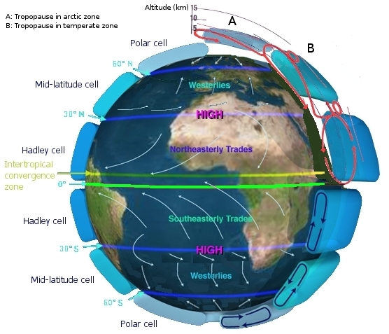
The figure shows the generalized circulation of the atmosphere. There are three generalized circulating cells of rising and sinking air called the Hadley Cell, the Ferrel or Midlatitude Cell, and the Polar Cell. Solar energy falling on the equatorial belt heats the air and causes it to rise. The rising air cools and its contained moisture falls back on the tropics as rain. The drier air then continues to spread toward the north and south where it collides with the Ferrel Cell and they sink back at about 30 degrees north and south latitudes. This sinking drier air creates belts of predominant high pressure along which desert conditions prevail in what are called the “horse latitudes.” These belts of predominantly high pressure have air that descends along these belts and flows either north to become the westerlies or south to become the trade winds. These circulation cells in the atmosphere rising in the tropics and polar regions and sinking in the horse latitudes produce the desert belts along the horse latitudes at approximately 30 degrees north and south of the equator [2]. Note the arrows indicating general directions of winds in the latitude zones. The trade winds are predominant in the tropics and the westerlies in the mid-latitudes.
 via Wikimedia Commons" width="347px" height="305px" src="/@api/deki/files/7712/Central_Basin_and_Range_ecoregion-300x264.png">
Other deserts have other atmospheric phenomena to owe (at least part of) their origin, like the desert of Utah, Nevada, and the surrounding areas called the Great Basin Desert [3]. This desert, while having some sinking air effects due to global circulation, is also a rain shadow desert produced as moist air from the Pacific rises by orthographic lifting over the Sierra Nevada (and other) Mountains and loses moisture from previous condensation and precipitation on the rainy side of the range(s).
 CC BY-SA 3.0 or GFDL], via Wikimedia Commons" width="230px" height="322px" src="/@api/deki/files/7713/Atacama_map.svg_-214x300.png">
One of the driest places on earth is the Atacama Desert of northern Chile [4]. This is a strip along the west coast of South America, west of the Andes, lying north of 30 degrees south latitude, at the southern edge of the trade wind belt. Warm moist air moves west across the Amazon basin and rises over the Andes where it loses moisture, its precipitation falling on the rain forest side of the mountains. Once over the mountains, it descends onto the Atacama where it meets air cooled by the cold Peru (Humboldt) ocean current flowing north along the coast. This is considered to be the driest (non-polar) place on earth with locations in the Atacama having not received any precipitation for periods of years [5].
 via Wikimedia Commons" width="277" src="/@api/deki/files/7715/polar_vortex-277x300.jpg">
Referring again to the figure above, note that the polar regions are also predominantly high-pressure areas of descending cold and dry air. Another circulation cell occurs there known as the Polar Cell [6]. Here, air not only descends convectively because it is cold, but cold air can hold much less moisture than warm air, and thus the driest and coldest places on Earth are the polar deserts. Antarctica is not only currently the driest land on Earth today, but any land that occupies the poles in Earth history should always be dry.
Coriolis Effect
GFDL or CC-BY-SA-3.0], via Wikimedia Commons" width="200" src="/@api/deki/files/7714/13.2_Corioliskraftanimation.gif">
In a non-rotating Earth, air would rise at the equator, sink at the poles, creating one circulation cell. However, as noted above, Earth has three cells. Why? As objects move on a rotating sphere, an effect called the Coriolis Effect occurs which causes a deflection in the motion. In the northern hemisphere, this deflection is to the right; in the southern hemisphere, it is to the left. This has two consequences on masses of air (and water) moving on the earth. The lower air in the Hadley Cells moves toward the equator over the earth’s surface. This air is deflected to the right in the northern hemisphere and to the left in the southern hemisphere creating the trade winds that carried European explorers to South America and the Caribbean. The midlatitude cells move surface air north toward the pole in the northern hemisphere (and south in the southern hemisphere) from the horse latitudes which is deflected again to the right (or left in the southern) producing the zone of westerlies. High above the Earth, the rising air from the equator would attach to the sinking air at the poles, but again, it is deflected, causing instead sinking air at 30° and rising at 60°. This splits the circulation into three cells instead of one.
To understand the Coriolis Effect, first consider motion along the meridians (the lines connecting the poles and running north-south). The earth rotates toward the east, i.e. everything on Earth moves at an eastward speed depending on its latitude. At a given latitude, objects possess a certain momentum of that motion depending on the length of the radius from its latitude to the rotational axis of the Earth. In the northern hemisphere, if the object is moving north, it has greater momentum toward the east than other objects at the new more northerly latitude. If it moves south, it has less momentum than other objects at that new more southerly latitude. It, therefore, tends to move to the right compared to fixed locations at that new latitude. The opposite happens in the southern hemisphere.
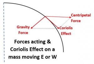
Now consider motion in an east-west direction again thinking of the momentum imparted by the radius from the Earth’s rotational axis. The centripetal effect of Earth’s rotation causes objects on the earth to tend to be forced outward perpendicular to the rotational axis, the centripetal effect or “force.” Since gravity holds things on the earth’s surface (the gravitational force points toward the Earth’s center, perpendicular to the surface), they do not actually fly outward of course. But considering the components of force involved acting on a mass at or above the Earth’s surface, the centripetal component is perpendicular to the Earth’s spin axis. The component of gravity is perpendicular to the earth’s surface pointing toward the Earth’s center. If the object is moving eastward, the speed of the object adds to the earth’s rotational speed and the centripetal effect is enhanced, thus the net effect of gravity and the centripetal component parallel to the surface causes deflection to the right (left in the southern hemisphere). If the object is moving west, its speed subtracts from the rotational speed and reduces the centripetal effect. Deflection is again to the right (left in the southern hemisphere). At any direction of motion, the meridional and the centripetal effects combine, thus no matter which direction an object moves on the rotating earth, there is a tendency for deflection to the right in the northern hemisphere (left in the southern).
The objects of greatest interest in geoscience that are affected by the Coriolis Effect on earth are air and water masses. Since wind patterns, especially prevailing patterns, cause ocean currents, then water masses feel it as well. In reality, any object moving on the earth experiences it. For example, the Coriolis Effect must be taken into account by artillerymen calculating the trajectory of artillery shells for accuracy in hitting targets over long distances.
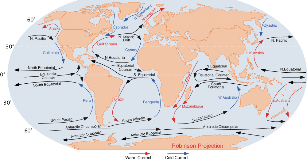
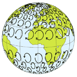
The Coriolis effect creates large sub-circular rotating currents called gyres in the oceans, turning clockwise in the northern hemisphere and counterclockwise in the southern under the Coriolis Effect. These currents bring cold water along the west coasts of both North and South America contributing to the drier climates of the Atacama and Central and Southern California. The Coriolis Effect acting on both the atmosphere and ocean is a major contributor to climate and weather on the earth.
 via Wikimedia Commons" width="336" src="/@api/deki/files/7727/Jetstreamconfig.jpg">
An application of the Coriolis Effect can be seen on the TV weather report. High-pressure systems are typically shown by a large “H” and indicate dry conditions, and low-pressure systems by a large “L” indicating clouds or precipitation. Air flows outward from a high and because of the Coriolis Effect, it rotates clockwise (to the right). It flows inward to a low and again turns to the right, rotating counterclockwise. Of course weather reports in the Southern Hemisphere show the opposite. Another interesting realization from the Coriolis Effect and the Zone of Westerlies is that weather systems tend to move from west to east across both North America and the southern part of South America. The high pressures and low pressures that exist due to uneven heating of the atmosphere and the Coriolis Effect create the high and low pressures on the weather map. The chaotic nature of the atmosphere (and fast-moving flows like the Jet Stream) makes these high and low pressures constantly and consistently move. This is important, because at 30 degrees, without this movement, low pressure would never exist! This means rain would never arrive. Even in the driest parts of this zone, like the Atacama, it rains on occasion. High pressure normally exists here, but just not all the time. These air movements, both prevailing and sporadic, are thus important in understanding climate and its geological implications.