
2.2: Soil Classification and Mapping
- Page ID
- 14718

Learning Objectives
- Become familiar with the 12 soil orders.
- Understand the structure of Soil Taxonomy.
- Become familiar with the contents of a county soil survey report.
- Use a soil survey report for land use evaluation.
The word, “taxonomy” is based on the Greek words “taxis”, meaning arrangement; and “nomia”, meaning method. In biology, taxonomy refers to a hierarchical system in which organisms are grouped based on shared characteristics, with domains and kingdoms at the top of the hierarchy, and genus and species at the lowest levels. Similarly, Soil Taxonomy is a hierarchical system used to group soils based on observable or measurable characteristics. A common application of soil classification (the act of identifying the taxonomic classification for a given soil) is to develop models of how soils of different classifications associate with one another within a landscape, which can eventually be used in soil mapping. The primary concepts of soil classification using Soil Taxonomy will be reviewed in this lab, followed by an overview of the Web Soil Survey (United States Department of Agriculture Natural Resources Conservation Service, 2016).
Materials
- Four soil monoliths (Crete, Clark, Morrill, and Chase soil series)
- Printed county soil survey reports
- Computer with internet access and a projector
Note
For this lab, you will need to bring a laptop or tablet to use. If you do not have a laptop or tablet, please share with a partner.
Recommended Reading
- Illustrated Guide to Soil Taxonomy (Soil Survey Staff, 2015)
- From the Surface Down: An Introduction to Soil Surveys for Agronomic Use (USDA NRCS, 2010)
Prelab Assignment
Using the assigned readings and the introduction to this lab, consider the questions listed below. These definitions/questions will provide a concise summary of the major concepts addressed in the lab. They are also relevant to the soil survey report and are useful study notes for exams.
- Explain the difference between a profile, a pedon, and a polypedon.
- Describe the key properties or diagnostic features for each of the following diagnostic epipedons:
- Mollic:
- Umbric:
- Histic:
- Ochric:
- Describe the key properties or diagnostic features of the following diagnostic subsurface horizons:
- Argillic:
- Kandic:
- Natric:
- Calcic:
- Spodic:
- Oxic:
- Cambic:
- List the soil moisture regimes from dries to wettest, and note the criteria for each.
- Explain the difference between a soil phase and a soil consociation.
- What are the 12 soil orders? Describe the key properties or diagnostic features of each.
- What are the six formal categories of Soil Taxonomy?
Introduction
Soils can vary widely in their properties, and each has a unique arrangement of layers or horizons. The soil profile description provides the information that distinguishes one soil from another. Review the following example of a profile description, and note the explanation of terms in Table 4.1.
Harney silt loam [adapted from the National Cooperative Soil Survey (1997)]
- Ap – 0 to 9 in; dark grayish brown (10YR 4/2) silt loam, very dark grayish brown (10YR 3/2) moist; moderate medium granular structure; slightly hard, very friable; many fine roots; slightly acid; clear smooth boundary. (4 to 14 in thick)
- AB – 9 to 12 in; dark grayish brown (10YR 4/2) silt loam, very dark grayish brown (10YR 3/2) moist; moderate fine subangular blocky structure; hard, friable; many fine roots; neutral; clear smooth boundary. (0 to 10 in thick)
- Bt1 – 12 to 18 in; grayish brown (10YR 5/2) silty clay loam, dark grayish brown (10YR 4/2) moist; moderate medium subangular blocky structure; very hard, very firm; few fine roots; moderately alkaline; clear smooth boundary.
- Bt2 – 18 to 28 in; grayish brown (10YR 5/2) silty clay loam, dark grayish brown (10YR 4/2) moist; strong medium subangular blocky structure; very hard, very firm; few fine roots; moderately alkaline; gradual smooth boundary. (Combined thickness of the Bt horizon is 10 to 26 in)
- BCk2 – 8 to 35 in; brown (10YR 5/3) silty clay loam, brown (10YR 4/3) moist; moderate medium subangular blocky structure; hard, firm; few fine roots; many soft accumulations of carbonates; strong effervescence; moderately alkaline; gradual smooth boundary. (0 to 16 in thick)
- Ck3 – 5 to 47 in; pale brown (10YR 6/3) silt loam, brown (10YR 5/3) moist; massive; slightly hard, friable; common soft accumulations of carbonates; strong effervescence; moderately alkaline; gradual smooth boundary. (0 to 20 in thick)
- C – 47 to 60 in; pale brown (10YR 6/3) silt loam, brown (10YR 5/3) moist; massive; slightly hard, friable; strong effervescence; moderately alkaline.
| Morphological property | Description | Morphological property | Description |
|---|---|---|---|
| Horizon designation | Ap | Structure grade | Moderate |
| Upper depth | 0 in | Structure size | Medium |
| Lower depth | 9 in | Structure type | Granular |
| Color name | Dark grayish brown | Moist consistence | Very friable |
| Munsell hue | 10YR | Roots | Many fine roots |
| Munsell value | 4 | pH | Slightly acid |
| Munsell chroma | 2 | Boundary | Clear smooth |
| Textural class | Silt loam |
Table adapted from King et al. (2003).
Completing a soil profile description involves a systematic approach:
- Observing the landscape setting.
- Examining the morphological features like texture, structure, color, consistence, etc. of the soil to distinguish any layers or horizons
- Describing in detail the texture, structure, color, consistence, and other important features of each horizon.
- Assigning horizon designations to each layer.
- Classifying the soil on the basis of its morphology and horizonation.
Soil Morphology and Land Use
Criteria that rate soils for a particular use are important to land use planning and land management decisions. Guidelines based on these criteria facilitate uniform and consistent land evaluations. Soil-based criteria can be developed for nearly any land use. To prepare a soil rating scheme, the following are required:
- Precise definition of the land use
- A list of soil properties affecting the use
- Limits for each soil property that would be favorable or unfavorable for the land use.
A comprehensive classification system is important for any science: soil science, plant science, biology, geology, among many others. Effective taxonomy allows us to organize knowledge and learn new relationships. Soil Taxonomy helps in extrapolating soil management research among similar soils around the world. Soil Taxonomy is a quantitative system based on soil properties that can be observed or measured, organized in a hierarchy based on six categories beginning with 12 broad soil orders and narrowing in specificity to more than 23,000 series. The following diagram illustrates the organization of a taxonomic name by category.
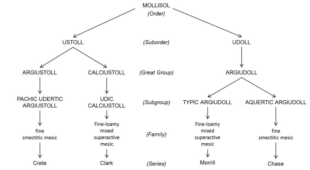
Table 4.2 Simplified key to the 12 soil orders
| Order | Major Diagnostic Features | Formative Element |
|---|---|---|
| Gelisols | Soils with permafrost or gelic material within 100 cm | el |
| Histosols | Other soils with >30% organic matter (>12% organic carbon) content to a depth of 40 cm or more |
ist |
| Spodosols | Other soils with a spodic horizon (illuvial humus, iron) within a depth of 200 cm | od |
| Andisols | Other soils with andic soil properties (low density, volcanic glass, pumice, etc.) in >= 50% of the upper 60 cm |
and |
| Oxisols | Other soils with an oxic horizon, or containing more than 40% clay in the surface 18 cm and a kandic horizon with less than 10% weatherable minerals (highly weathered) |
ox |
| Vertisols | Other soils containing more than 30% clay in all horizons and cracks that open and close periodically (shrinking/swelling) |
ert |
| Aridisols | Other soils with some diagnostic subsoil horizon(s) and an aridic soil moisture regime | id |
| Ultisols | Other soils with an argillic or kandic horizon and a base saturation at pH 8.2 of <35% at a depth of 180 cm |
ult |
| Mollisols | Other soils with a Mollic epipedon and a base saturation at pH 7 of 50% in all depths above 180 cm |
oll |
| Alfisols | Other soils with an argillic, kandic, or natric horizon (and a base saturation at pH 8.2 of >35% at a depth of 180 cm) |
alf |
| Inceptisols | Other soils with an umbric, mollic, or plaggen epipedon or a cambic horizon | ept |
| Entisols | Other soils | ent |
The formative elements are used in the names of suborders and lower taxonomic levels. (Table courtesy of R. Weil)
Many other formative elements can specify unique soil properties at each taxonomic level. Each formative element has a connotation for a given soil. These connotations of the formative elements used for suborders and great groups are listed in Table 4.3 and Table 4.4.
Table 4.3. Formative elements used to identify various suborders in Soil Taxonomy.
| Formative Element | Connotation | Formative Element | Connotation |
|---|---|---|---|
| alb | Presence of albic horizon (a bleached eluvial horizon) |
hist | Presence of histic epipedon |
| anthr | Presence of anthropic or plaggen epipedon |
hum | Presence of organic matter |
| aqu | Characteristics associated with wetness |
orth | The common ones |
| ar | Mixed horizons | per | Of year-round humid climates, perudic moisture regime |
| arg | Presence of argillic horizon (a horizon with illuvial clay) |
psamm | Sand textures |
| calc | Presence of calcic horizon | rend | Rendzinalike-high in carbonates |
| camb | Presence of cambric horizon | sal | Presence of salic (saline) horizon |
| cry | cold | sapr | Most decomposed stage |
| dur | Presence of a duripan | torr | Usually dry |
| fibr | Least decomposed stage | turb | Cryoturbation |
| fluv | Floodplains | ud | Of humid climates |
| fol | Mass of leaves | ust | Of dry climates, usually hot in summer |
| gyps | Presence of gypsic horizon | vitr | Resembling glass |
| hem | Intermediate stage of decomposition | xer | Dry summers, moist winters |
Table from King et al. (2003)
Table 4.4 Formative elements for names of great groups and their connotations
| Formative Element | Connotation | Formative Element | Connotation |
|---|---|---|---|
| acr | Extreme weathering | hist | Presence of organic materials |
| aer | Chroma >2, non-reducing | fragi | Fragipan |
| agr | Agric horizon | hum | Humus |
| al | High aluminum, low iron | hydr | Water |
| alb | Albic horizon | kand | Low activity 1:1 silicate clay |
| and | Ando-like | lithic | Near stone |
| anhy | Anhydrous | luv, lu | Illuvial |
| aqu | Water saturated | melan | Melanic epipedon |
| aren | Sandy | molli | With a mollic epipedon |
| argi | Argillic horizon | natr | Presence of a natric horizon |
| calc, calci | Calcic horizon | pale | Old development |
| camb | Cambric horizon | petr | Cemented horizon |
| chrom | High chroma | plac | Thin pan |
| cry | Cold | plagg | Plaggen horizon |
| dur | Duripan | plinth | Plinthite |
| dystr, dys | Low base saturation | psamm | Sand texture |
| endo | Fully water saturated | quartz, quartzi | High quartz |
| epi | Perched water table | rhod | Dark red colors |
| eutr | High base saturation | sal | Salic horizon |
| ferr | Iron | sapr | Most decomposed |
| fibr | Least decomposed | somb | Dark horizon |
| fluv | Floodplain | sphagn | Sphagnum moss |
| fol | Mass of leaves | sulf | Sulfur |
| fragloss | See frag and gloss | torr | Usually dry and hot |
| fulv | light-colored melanic horizon | ud | Humid climates |
| gyps | gypsic horizon | umber | Umbric epipedon |
| gloss | Tongued | ust | Dry climate, usually hot in summer |
| hal | Salty | verm | Wormy or mixed by animals |
| hapl | Minimum horizon | vitr | Glass |
| hem | Intermediate decomposition | xer | Dry summers, moist winters |
Table adapted from King et al. (2003)
A complete taxonomic name communicates a great deal of information about the soil if we understand each part of the name. As an example of the quantitative information revealed in a taxonomic name, the following classification name will be dissected by category. Consider, for example, the Harney soil, with a taxonomic classification of fine, smectitic, mesic Typic Argiustoll.
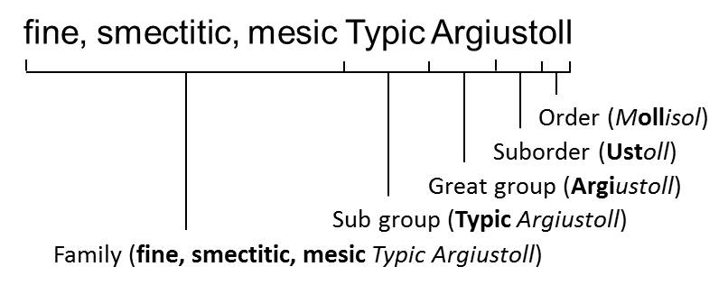
Table 4.5.Translation of the taxonomic classification of the Harney Series.
| Categories | Properties connoted |
|---|---|
| ORDER: Mollisol | Has a mollic epipedon and a base saturation of >50% to a depth of 1.8 m from the soil surface or to an impermeable layer |
| SUBORDER: Ustoll | has an ustic moisture regime; dry for as long as 90 days cumulatively per year |
| GREAT GROUP: Argiustoll | has an argillic horizon |
| SUBGROUP: Typic Argiustoll | typical of an Argiustoll, not intergrading toward another great group condition |
| FAMILY: fine, smectitic, mesic | the upper 50 cm of the argillic horizon has 35-60% clay; the dominant clay minerals are smectite minerals (montmorillonite, beidellite, and nontronite); the mean annual soil temperature at 50 cm is 8°C to 15°C (47°F to 59°F) |
| SERIES: Harney | differs from soils in the same family in based on color, parent material (loess), and calcium accumulation below 28 in. |
Table courtesy of C. J. Moorberg, adapted from King et al. (2003)
Activity 1: Practice Key to Soil Orders
![]() Now that you have studied the characteristics of the 12 soil orders, enter the most appropriate soil order name in each rectangle.
Now that you have studied the characteristics of the 12 soil orders, enter the most appropriate soil order name in each rectangle.
Activity 2: Structure of Soil Taxonomy
![]() To illustrate the structure of Soil Taxonomy, separate a complete taxonomic name into the six categories. Follow the example of the Harney silt loam in figure 4.2.
To illustrate the structure of Soil Taxonomy, separate a complete taxonomic name into the six categories. Follow the example of the Harney silt loam in figure 4.2.
Colby
Taxonomic Name: Fine-silty, mixed, superactive, calcareous, mesic Aridic Ustorthents
| Order | |
|---|---|
| Suborder | |
| Great Group | |
| Subgroup | |
| Family | |
| Series |
Goessel
Taxonomic Name: Fine, smectitic, mesic Typic Haplusterts
| Order | |
|---|---|
| Suborder | |
| Great Group | |
| Subgroup | |
| Family | |
| Series |
Wymore
Taxonomic Name: Fine, smectitic, mesic Aquertic Argiudolls
| Order | |
|---|---|
| Suborder | |
| Great Group | |
| Subgroup | |
| Family | |
| Series |
Activity 3: Interpreting Taxonomy
As a further exercise in understanding taxonomic names, complete the following questions. Use the list of taxonomic names of soils representative of Mollisols from the prairie pothole region of Iowa below to answer these questions.
The Des Moines lobe of the Wisconsin glaciation covered north-central Iowa with a deep layer of glacial deposits, and provides a good example of how taxonomic names depict important soil properties. The Clarion-Nicollet-Webster-Glenco topo-sequence, or “catena” (Figure 4.4), illustrates how Soil Taxonomy reflects wetness, or depth to a water table.
![]() Fill in the subgroup taxonomic name for soils in Table 4.6, and study how the terms change with wetness.
Fill in the subgroup taxonomic name for soils in Table 4.6, and study how the terms change with wetness.
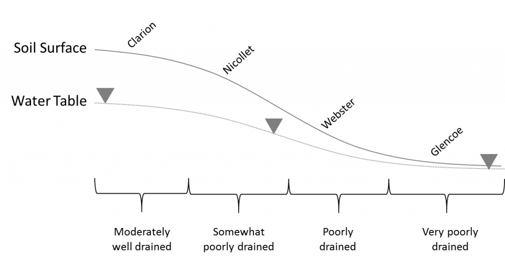
- Clarion series: Fine-loamy, mixed, superactive, mesic Typic Hapludolls
- Nicollet series: Fine-loamy, mixed, superactive, mesic Aquic Hapludolls
- Webster series: Fine-loamy, mixed, superactive, mesic Typic Endoaquolls
- Glencoe series: Fine-loamy, mixed, superactive, mesic Cumulic Endoaquolls
| Series | Drainage Class | Depth to Seasonal High Water Table | Subgroup Taxonomic Name |
|---|---|---|---|
| Clarion | Moderately Well | 61 - 102 cm (24 - 48 in) | |
| Nicollet | Somewhat Poorly | 30 – 61 cm (12 – 24 in) | |
| Webster | Poorly | < 30 cm (< 12 in) | |
| Glencoe | Very Poorly | < 30 cm (< 12 in), and accumulation of organic matter |
Table courtesy of C. J. Moorberg
Notice that the wetter the drainage class (that is, the shallower the depth to the seasonal high water table), the higher the “aqu” formative element becomes in the overall classification. That is because Soil Taxonomy prioritizes soil management considerations. The depth to the seasonal high water table would be a management concern for most land uses for the Nicollet, Webster, and Glencoe series; it would be of less concern for the Clarion series, and thus “aqu” is not included in the classification.
Also note that for the Glencoe series, in addition to having the “aqu” formative element as part of the suborder, the “cumulic” formative element has been designated in the subgroup. That formative element alludes to a “thickened epipedon” caused by the accumulation of organic matter. Because the water table is so shallow, little oxygen is available at the surface for a significant portion of the growing season. This slows decomposition, allowing organic matter to build, thus creating a thickened epipedon with lots of organic matter.
Activity 4: Practicing Soil Taxonomy Interpretations with State Soils of the US
State soils have been selected for all 50 states and three territories in the U.S. The group of soils represents a diverse sample of soil conditions and classifications. It serves as an interesting focus for a little practice at deciphering and understanding Soil Taxonomy. Use the attached list of state soils in Table 4.7 along with Table 4.2, Table 4.3, and Table 4.4 to answer the following questions:
![]() What is the most commonly recognized ORDER among the state soils?
What is the most commonly recognized ORDER among the state soils?
![]() Which of the soil ORDERS is not represented in the list of state soils?
Which of the soil ORDERS is not represented in the list of state soils?
![]() How many Oxisols are represented by the 53 soils?
How many Oxisols are represented by the 53 soils?
![]() What is the complete SUBORDER name for the state soil of Alaska?
What is the complete SUBORDER name for the state soil of Alaska?
![]() How many Vertisols are represented in the state soils?
How many Vertisols are represented in the state soils?
![]() In what soil property does the Downer soils of New Jersey differ from the Greenwich soils or Deleware?
In what soil property does the Downer soils of New Jersey differ from the Greenwich soils or Deleware?
![]() The state soil of South Carolina has a soil condition identified by its great group. What element is present in the upper 50 cm of this soil? (Hint: use Table 4.4)
The state soil of South Carolina has a soil condition identified by its great group. What element is present in the upper 50 cm of this soil? (Hint: use Table 4.4)
![]() What is the complete taxanomic name for the state soil of Kansas?
What is the complete taxanomic name for the state soil of Kansas?
Table 4.7. Soil Taxonomy classifications of state soils of the U.S.
| Series | State | Family Classification |
|---|---|---|
| Tanana | AK | coarse-loamy, mixed, superactive, subgelic Typic Aquiturbels |
| Bama | AL | fine-loamy, siliceous, subactive, thermic Typic Paleudults |
| Stuttgart | AR | fine, smectitic, thermic Albaquultic Hapludalfs |
| Casa Grande | AZ | fine-loamy, mixed, superactive, hyperthermic Typic Natrargids |
| San Joaquin | CA | fine, mixed, active, thermic Abruptic Durixeralfs |
| Seitz | CO | clayey-skeletal, smectitic Ustic Glossocryalfs |
| Windsor | CT | mixed, mesic Typic Udipsamments |
| Greenwich | DE | coarse-loamy, mixed, semiactive, mesic Typic Hapludults |
| Myakka | FL | sandy, siliceous, hyperthermic Aeric Alaquods |
| Tifton | GA | fine-loamy, kaolinitic, thermic Plinthic Kandiudults |
| Akina | GU | very-fine, kaolinitic, isohyperthermic Inceptic Haplustox |
| Hilo | HI | medial over hydrous, ferrihydritic, isohyperthermic Acrudoxic Hydrudands |
| Tama | IA | fine-silty, mixed, superactive, mesic Typic Argiudolls |
| Threebear | ID | medial over loamy, amorphic over mixed, superactive, frigid Oxyaquic Udivitrands |
| Drummer | IL | fine-silty, mixed, superactive, mesic Typic Endoaquolls |
| Miami | IN | fine-loamy, mixed, active, mesic Oxyaquic Hapludalfs |
| Harney | KS | fine, smectitic, mesic Typic Argiustolls |
| Crider | KY | fine-silty, mixed, active, mesic Typic Paleudalfs |
| Ruston | LA | fine-loamy, siliceous, semiactive, thermic Typic Paleudults |
| Paxton | MA | coarse-loamy, mixed, active, mesic Oxyaquic Dystrudepts |
| Sassafras | MD | fine-loamy, siliceous, semiactive, mesic Typic Hapludults |
| Chesuncook | ME | coarse-loamy, isotic, frigid Aquic Haplorthods |
| Kalkaska | MI | sandy, isotic, frigid Typic Haplorthods |
| Lester | MN | fine-loamy, mixed, superactive, mesic Mollic Hapludalfs |
| Menfro | MO | fine-silty, mixed, superactive, mesic Typic Hapludalfs |
| Natchez | MS | coarse-silty, mixed, superactive, thermic Typic Eutrudepts |
| Scobey | MT | fine, smectitic, frigid Aridic Argiustolls |
| Cecil | NC | fine, kaolinitic, thermic Typic Kanhapludults |
| Williams | ND | fine-loamy, mixed, superactive, frigid Typic Argiustolls |
| Holdrege | NE | fine-silty, mixed, superactive, mesic Typic Argiustolls |
| Marlow | NH | coarse-loamy, isotic, frigid Oxyaquic Haplorthods |
| Downer | NJ | coarse-loamy, siliceous, semiactive, mesic Typic Hapludults |
| Panistaja | NM | fine-loamy, mixed, superactive, mesic Ustic Haplargids |
| Orovada | NV | coarse-loamy, mixed, superactive, mesic Durinodic Xeric Haplocambids |
| Honeoye | NY | fine-loamy, mixed, semiactive, mesic Glossic Hapludalfs |
| Miamian | OH | fine, mixed, active, mesic Oxyaquic Hapludalfs |
| Port | OR | fine-silty, mixed, superactive, thermic Cumulic Haplustolls |
| Hazleton | PA | loamy-skeletal, siliceous, active, mesic Typic Dystrudepts |
| Bayamon | PR | very-fine, kaolinitic, isohyperthermic Typic Hapludox |
| Narragansett | RI | coarse-loamy over sandy or sandy-skeletal, mixed, active, mesic Typic Dystrudepts |
| Bohicket | SC | fine, mixed, superactive, nonacid, thermic Typic Sulfaquents |
| Houdek | SD | fine-loamy, mixed, superactive, mesic Typic Argiustolls |
| Dickson | TN | fine-silty, siliceous, semiactive, thermic Glossic Fragiudults |
| Houston Black | TX | fine, smectitic, thermic Udic Haplusterts |
| Taylorsflat | UT | fine-loamy, mixed, superactive, mesic Xeric Haplocalcids |
| Pamunkey | VA | fine-loamy, mixed, semiactive, thermic Ultic Hapludalfs |
| Victory | VI | loamy-skeletal, mixed, superactive, isohyperthermic Typic Haplustepts |
| Tunbridge | VT | coarse-loamy, isotic, frigid Typic Haplorthods |
| Tokul | WA | medial, amorphic, mesic Aquic Vitrixerands |
| Antigo | WI | coarse-loamy over sandy or sandy-skeletal, mixed, superactive, frigid Haplic Glossudalfs |
| Monongahela | WV | fine-loamy, mixed, semiactive, mesic Typic Fragiudults |
| Forkwood | WY | fine-loamy, mixed, superactive, mesic Ustic Haplargids |
Table courtesy of J. Kleiss and D. Lindbo
Activity 5: Soil Survey Reports
As an introduction to soil reports, look through a typical printed county soil survey report; take note of the manual’s organization and the extensive content. The report begins with some background information on the county, along with an overview of how the survey was conducted. The county soil conditions are described, and the soil mapping units are discussed in detail. A colored map displays these general soil units.
Following the brief overview are detailed soil map unit descriptions. These show the symbol that is on the soil map, the dominant soil series, topsoil texture and range of slope found in the unit. The descriptions of each map unit details the landscape setting, general properties, and major use and management considerations. If other soils are present in the map unit, this is an important part of map unit description. The next section of the soil report offers specific use and management suggestions and discusses how specific types of land use ratings were formulated. This is followed with an overview of what specific kinds of soil data are included.
Specific information on soil classification and detailed profile descriptions for each soil are followed by a glossary of terms used in the report. A sequence of tables provides detailed ratings on a wide range of land uses. This interpretative information is offered for each soil map unit. The last section of the report shows the soil maps on an aerial photograph base.
To become familiar with county soil survey reports select one provided and review the table of contents and the summary list of tables. Leaf through the report and note the following sections:
- Map Unit descriptions
- Use and management of soils
- Classification and profile descriptions
- Interpretive tables
- General soil map
- Soil legend
- Soil maps
The United States Department of Agriculture Natural Resource Conservation Service (USDA NRCS) today provides these soil surveys in a digital format through the Web Soil Survey (United States Department of Agriculture Natural Resources Conservation Service, 2016). The Web Soil Survey provides all the information previously contained in the county soil survey reports. It also contains additional tools and information that has not been available in printed versions of the soil surveys. Another advantage of the Web Soil Survey is that the information contained in it can be updated as needed, instead of being updated following new surveys of the same county, which take 30 to 60 years! Your instructor will walk you through some of the main features of the Web Soil Survey and show you how to request a PDF copy of a soil survey report for a designated area. You will use these skills for your Soil Survey Report assignment.
Assignment: Soil Survey Report
For this lab, you will be preparing a soil survey report. The report assignment will be provided to you at the beginning of the lab. Your instructor will go over what to include in the report and where to collect the necessary information from the Web Soil Survey.
Subsequent Lab Set-Up
Some activities require preparation beyond the lab period and must be set up ahead of time. The soil texture by hydrometer activity in the Soil Texture and Structure lab involves dispersing soil particles chemically, which requires time for the reactions to take place. We will do this now, so the samples are ready next week.
For each of the three soils provided, do the following:
Weigh out 30.0 g of dry soil (assume oven-dry) into a 250-ml Erlenmeyer flask.
Wash sides of flask with distilled water from a wash bottle.
Add 100 ml of distilled water using a graduated cylinder. Then add 10 ml of sodium hexametaphosphate solution (500 g/L) from the dispenser on the sodium hexametaphosphate bottle.
Swirl to mix.
Wash sides of flask with distilled water from a wash bottle.
Cover the flask with Parafilm and label the flask with your lab section, table number, and soil type. Store the flasks in the location specified by your instructor for the next laboratory period.