
2.1: Soil Formation
- Page ID
- 14717

Learning Objectives
- Recognize common rocks and minerals.
- Relate rock and mineral composition to (a) ease of weathering and (b) products of weathering.
- Understand the general geology of Kansas.
- Know the major types of soil parent materials.
- Know the five factors of soil formation.
- Recognize major soil differences as they are affected by differences in soil formation.
Soils are incredibly diverse in their appearance, form, function, and use throughout the globe. A fundamental understanding of soil formation allows us to more appropriately manage those soil resources. For example, the Flint Hills that surround Manhattan, Kansas encompass some of the last remaining tallgrass prairie in the U.S., primarily due to the soil. The rocky outcroppings, steep slopes, and boulder-ridden soil profiles make tillage of the soils for row crop production nearly impossible. However, the landscape lends itself well to grazing, allowing the region to be managed as rangeland instead of wheat fields. However, at a finer scale, land uses other than rangeland do exist in the region; and soil mapping allows us to identify those soils suitable for such land uses. The concepts of soil formation covered in this lab provide the basis for soil mapping, which is covered in more detail in Soil Classification and Mapping.
Materials
- Mineral collection (Item #GEO2194, Carolina Biological Supply Company, Burlington, North Carolina, U.S.)
- Igneous, metamorphic, and sedimentary rock collections (Item # GEO115, Carolina Biological Supply Company, Burlington, North Carolina, U.S.)
- Rock cycle chart (Item #GEO8658, Carolina Biological Supply Company, Burlington, North Carolina, U.S.)
- Generalized Geologic Map of Kansas (Kansas Geological Survey, Lawrence, Kansas, U.S.)
- Parent material collection (Various sources and peer instructors from around the U.S.)
- Soil monoliths (Colby, Ulysses, Tivoli, Cherokee, and Kenoma soil series)
Recommended Reading
- Weathering and Soil (Earle, 2015)
- Soil Formation and Classification (USDA NRCS, 2020)
Prelab Assignment
Read the recommended reading resources and the introduction to this lab, then answer consider the questions listed below. These definitions/questions will provide a concise summary of the major concepts addressed in the lab. They are also useful as study notes for exams.
- Define and Explain the differences between igneous rock, sedimentary rock, and metamorphic rock.
- Define and give a specific example of each of the following terms:
- Physical weathering
- Chemical weathering
- Primary mineral
- Secondary mineral
- Define the following three parent materials:
- Alluvium
- Colluvium
- Residuum
- What are the five factors of soil formation?
Introduction
Understanding soils and why they are different requires knowing how soil forms. Soils are the product of weathering of pre-existing parent materials, so knowing rocks and minerals is important to understanding differences among soils.
Minerals
Minerals are naturally occurring inorganic substances with characteristic composition and physical properties. Based on their origin, minerals are classified as primary or secondary. Primary minerals form during cooling and solidification of the original molten material of the earth’s crust. Secondary minerals form from the decomposition products of primary minerals.
Rocks
Rocks are combinations of two or more minerals. The three major groups of rocks are igneous, sedimentary, and metamorphic. Igneous rocks form as molten mineral matter cools and solidifies. They are the most abundant group of rocks in the earth’s crust. Sedimentary rocks originate from weathering of igneous rocks. Sedimentary rocks are the most abundant rock type on the earth’s surface. Metamorphic rocks form when igneous or sedimentary rocks are modified by heat and/or pressure.
Igneous rocks
Types of igneous rocks, their mineral composition, and texture (grain size) are shown in Figure 3.1. The vertical arrangement of rocks in the figure is based on texture, from coarse to fine. The texture is dictated by the rate of cooling of the molten magma from which the rocks form. When the magma cools slowly, far below the earth’s surface, sufficient time is available for relatively large mineral crystals to form. In contrast, when magma cools rapidly at the earth’s surface, minimal time is available for crystallization, and the crystals are small. Thus, rocks forming deep within the earth (intrusive rocks like granite) are coarse textured, while rocks forming at the surface (extrusive rocks like obsidian) are fine.
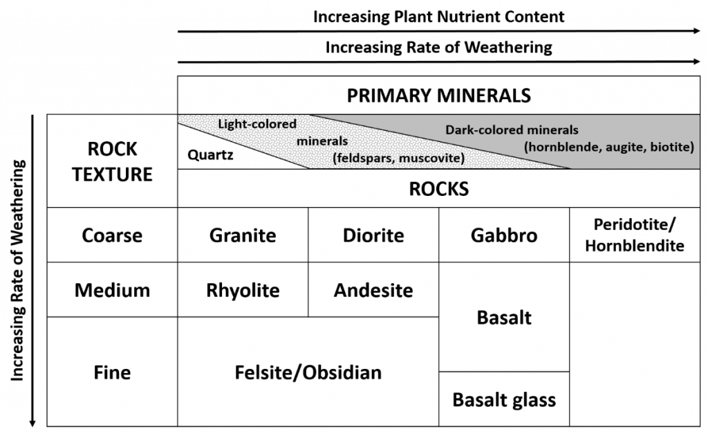
The horizontal arrangement in Figure 3.1 is based on mineral composition. For example, granite is composed mostly of quartz and light-colored minerals like feldspars and muscovite. In contrast, peridotite is composed mostly of dark-colored minerals (hornblende, augite, and biotite).
Both the mineral makeup of igneous rocks and their texture are important in soil formation. Minerals vary in solubility. Biotite (K(Mg,Fe)3AlSi3O10(OH)2) contains more Mg and Fe, and is more soluble than orthoclase feldspar (KAlSi3O8), which itself is more soluble than quartz (SiO3). Texture affects the amount of surface area exposed to weathering; that is, small crystals have a large specific surface area (surface area/unit of weight) and thus dissolve faster than large crystals. Therefore, from Figure 3.1, we can generalize that the rate of weathering of igneous rocks increases from the upper left corner (granite) to the lower right corner; in other words, as grain size decreases, solubility increases.
Sedimentary rocks
Sedimentary rocks are classified as clastics or precipitates. Clastics are rocks formed through physical means: fragments of igneous rocks or sediments derived from igneous rocks are cemented together to form sedimentary rocks. The cementing agents include clay, iron oxide, silica, or calcium carbonate. Texture of the resulting rocks can vary.
| Texture | Examples | Particle Diameter, mm |
|---|---|---|
| Coarse | Conglomerates | >2 (pebbles to boulders) |
| Medium | Sandstone | 0.05 to 2.00 (sand size) |
| Fine | Shale | <0.005 (silt/clay) |
Precipitate-type sedimentary rocks form as ions from solution precipitate either chemically or biochemically. Biochemical precipitates usually involve marine animals and may contain fossils and shells. Limestone is an example of a precipitate sedimentary rock.
Metamorphic rocks
One way to explain metamorphic rocks is the types of igneous or sedimentary rocks from which they were formed. Table 3.2 provides some examples.
| Original Rock | Metamorphic Rock |
|---|---|
| Granite | Gneiss |
| Shale | Slate |
| Sandstone | Quartzite |
| Limestone | Marble |
Activity 1: Elemental composition of minerals
Table 3.3 shows several primary minerals (formed as magma cools) and secondary minerals (formed by weathering or recrystallization of weathering products, i.e., in sedimentary rocks), their composition, and their resistance to weathering.
| Primary Mineral† | Composition | Secondary Mineral‡ | Composition | Weathering |
|---|---|---|---|---|
| Goethite | FeOOH | Most resistant | ||
| Hematite | Fe2O3 | ↓ | ||
| Gibbsite | Al2O3•3H2O | ↓ | ||
| Quartz | SiO2 | ↓ | ||
| Clay minerals | Al silicates | ↓ | ||
| Muscovite | KAl3Si3O10(OH)2 | ↓ | ||
| Microcline | KAlSi3O8 | ↓ | ||
| Orthoclase | KAlSi3O8 | ↓ | ||
| Biotite | KAl(Mg,Fe)3Si3O10(OH)2 | ↓ | ||
| Albite | NaAlSi3O8 | ↓ | ||
| Hornblende | Ca2Al2Mg2Fe3Si6O22(OH)2 | ↓ | ||
| Augite | Ca2(Al,Fe)4(Mg,Fe)4Si6O24 | ↓ | ||
| Anorthite | CaAl2Si2O8 | ↓ | ||
| Olivine | (Mg,Fe)2SiO4 | ↓ | ||
| Dolomite | CaCO3•MgCO3 | ↓ | ||
| Calcite | CaCO3 | ↓ | ||
| Gypsum | CaSO4•2H2O | Least resistant |
†Primary minerals are found in igneous rocks or metamorphosed igneous rocks.‡Secondary minerals are most commonly found in sedimentary rocks. §Table courtesy of King et al. (2003).
![]() Using the data in Table 3.4, put a checkmark in each column box where a mineral contains the nutrient for that column. Hornblende is completed as an example.
Using the data in Table 3.4, put a checkmark in each column box where a mineral contains the nutrient for that column. Hornblende is completed as an example.
| N | P | K | Ca | Mg | S | Fe | Mn | Cu | Zn | |
|---|---|---|---|---|---|---|---|---|---|---|
| Primary Minerals | ||||||||||
| Quartz | ||||||||||
| Muscovite | ||||||||||
| Orthoclase | ||||||||||
| Biotite | ||||||||||
| Hornblende | ||||||||||
| Olivine | ||||||||||
| Augite | ||||||||||
| Albite | ||||||||||
| Secondary Minerals | ||||||||||
| Goethite | ||||||||||
| Gibbsite | ||||||||||
| Dolomite | ||||||||||
| Calcite | ||||||||||
| Gypsum |
The soil based plant nutrients are listed below.
Primary Macronutrients
- Nitrogen (N)
- Phosphorus (P)
- Potassium (K)
Secondary Macronutrients
- Calcium (Ca)
- Magnesium (Mg)
- Sulfur (S)
Micronutrients
- Iron (Fe)
- Manganese (Mn)
- Boron (B)
- Zinc (Zn)
- Copper (Cu)
- Chlorine (Cl)
- Molybdenum (Mo)
- Nickel (Ni)
![]() Which mineral(s) in Table 3.3 will result in the formation of the most fertile soil?
Which mineral(s) in Table 3.3 will result in the formation of the most fertile soil?
![]() Which mineral(s) in Table 3.3 will result in the formation of the least fertile soil?
Which mineral(s) in Table 3.3 will result in the formation of the least fertile soil?
Activity 2: Mineral and Rock Investigation
Examine the rock and mineral specimens on display. Note differences in color, color pattern, shape, and the cleavage angles on the mineral specimens. For the rock examples, note the differences in the three broad classes of rocks: igneous, metamorphic, and sedimentary. Study the size of the individual minerals contained in the rocks. Examine the color patterns and the arrangement of the minerals. Try to identify specific minerals contained in the rocks.
As you study the rock samples, refer to the Table 3.5. Note the differences in mineral size (fine-texture versus coarse-texture), the differences in mineral content between the dark (basic or mafic) and the light (acid or felsic), and the elemental content of the igneous rock types.
![]() As you review the rock and mineral types, complete Table 3.5 and Table 3.6. These tables will provide a useful summary of properties of the major rocks and minerals important in soil formation.
As you review the rock and mineral types, complete Table 3.5 and Table 3.6. These tables will provide a useful summary of properties of the major rocks and minerals important in soil formation.
| Mineral | Color | Plant Nutrients | Relative Rate of Weathering |
|---|---|---|---|
| Quartz | |||
| Muscovite mica | |||
| Biotite mica | |||
| Hornblende | |||
| Calcite | |||
| Dolomite |
Table courtesy of King et al. (2003).
| Rock | Class | Grain size | Dominant minerals | Rate of weathering | Potential nutrient supply |
|---|---|---|---|---|---|
| Igneous, metamorphic, or sedimentary | Coarse or fine | Fast, moderate, or slow | High, medium, or low | ||
| Granite | |||||
| Gabbro | Igneous | Coarse | Feldspars, muscovite, hornblende, augite | Moderate | High |
| Gneiss | |||||
| Schist | Metamorphic | Coarse | Mica, quartz, hornblende | Moderate | Medium |
| Quartzite | |||||
| Slate | |||||
| Limestone | |||||
| Sandstone | |||||
| Shale |
Table courtesy of King (2003).
Activity 3: Rock Cycle Model
The rock cycle model is two dimensional and shows a cross-section through the earth’s crust. Vertically, it represents a depth of two to five miles. Horizontally, it could represent distances ranging from a few miles to several hundred miles.
Examine first the rock cycle showing the relationships between igneous, sedimentary, and metamorphic rocks. Note the processes/factors (heat, pressure, erosion, etc.) that change one rock class to another.
![]() Shale can be transformed into shist through metamorphism. What metamorphic rock acts as an intermediate?
Shale can be transformed into shist through metamorphism. What metamorphic rock acts as an intermediate?
![]() What process is responsible for the formation of layers, a characteristic of sedimentary rocks?
What process is responsible for the formation of layers, a characteristic of sedimentary rocks?
![]() What two forces can cause quartz in a sandstone rock to be changed to metamorphic quartzite?
What two forces can cause quartz in a sandstone rock to be changed to metamorphic quartzite?
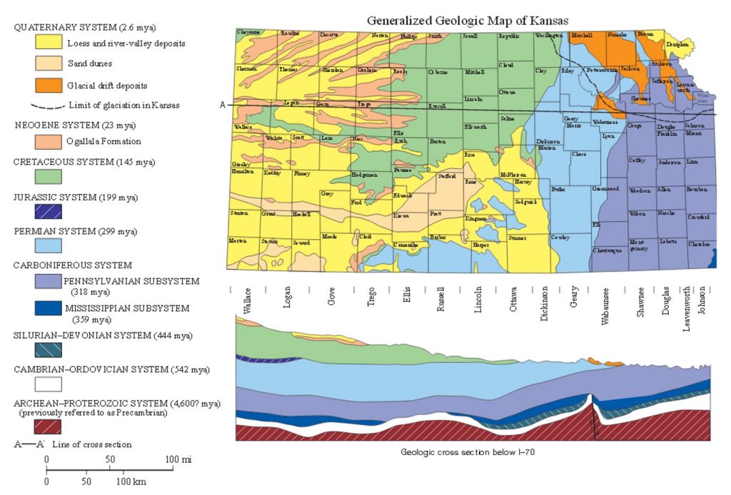
Activity 4: Geology of Kansas
In this exercise, you will be using the geologic map of Kansas on the next page. This map contains much information on different sedimentary materials, as well as glacial and wind-blown sediment. Review the map, and answer the following questions.
![]() Of the three different major rock classes (igneous, metamorphic, sedimentary), only one is found in Kansas. Name the rock class that is found in Kansas. Also, name one rock formation from the map, and describe where in the state that rock formation can be observed.
Of the three different major rock classes (igneous, metamorphic, sedimentary), only one is found in Kansas. Name the rock class that is found in Kansas. Also, name one rock formation from the map, and describe where in the state that rock formation can be observed.
![]() What is the oldest deposit exposed on the surface in Kansas? How old is it, and where in the state does it surface?
What is the oldest deposit exposed on the surface in Kansas? How old is it, and where in the state does it surface?
![]() Describe the pattern occurring between sediment age and its order among other sediment layers from most deep to most shallow.
Describe the pattern occurring between sediment age and its order among other sediment layers from most deep to most shallow.
![]() Where have glaciers deposited material in Kansas?
Where have glaciers deposited material in Kansas?
![]() What sedimentary deposit(s) underlies Manhattan, KS? How old is it?
What sedimentary deposit(s) underlies Manhattan, KS? How old is it?
Activity 5: Types of Soil Parent Materials
All mineral soils develop from the rocks and minerals of the earth’s crust. However, the original rock material commonly is transported or reworked by some mechanism before a soil is formed. Variations in the history of the initial material lead to a range of types of soil parent materials. Table 3.7 summarizes various categories of soil parent materials:
![]() Describe the various types of parent materials on display.
Describe the various types of parent materials on display.
| Mode of transportation | Mode of deposition | Name of parent material |
|---|---|---|
| Gravity | Gravity | Colluvium |
| Water | Stream | Alluvium |
| Water | Lake | Lacustrine |
| Water | Ocean | Marine |
| Ice | Ice | Till, moraine |
| Ice | Meltwater | Outwash (alluvium, lacustrine) |
| Wind | Suspension | Loess |
| Wind | Saltation, Creep | Dunes |
Table based on King (2003).
Activity 6: Soil Forming Factors
While the soil parent material is important to the type of soil that may form, other forces or factors also influence weathering and soil formation. The resulting soil properties we observe are the result of the interaction of these factors.

As Figure 3.3 suggests, soil formation is a continuum. As any one factor or influence changes, the final soil product will vary. An infinite number of combinations of soil forming processes yield many different soil properties. Understanding the role of each soil forming factor allows us to understand or predict soil occurrence.
Study the soil monoliths (profiles) and note the differences in color, depth, and horizonation. Review the major soil forming factors for each as a means of explaining the differences you observe.
![]() After studying the monoliths on display and their accompanying Official Series Descriptions, name the soil-forming factor(s) most responsible for the differences in the following soils. (There may be more than one.)
After studying the monoliths on display and their accompanying Official Series Descriptions, name the soil-forming factor(s) most responsible for the differences in the following soils. (There may be more than one.)
| Soils | Main soil-forming factor(s) causing difference: |
|---|---|
| Example: Norfolk versus Cecil | Parent Material: Norfolk = Coastal Plain sediments Cecil = granite or gneiss |
| Colby versus Ulysses | |
| Ulysses versus Tivoli | |
| Cherokee versus Kenoma |
COLBY SERIES
The Colby series consists of very deep, well drained and somewhat excessively drained, moderately permeable soils that formed in loess. Colby soils are found on plains and hillslopes of tableland in the Central High Tableland. Slopes range from 0 to 60%. Mean annual precipitation is about 450 millimeters (18 in), and the mean annual temperature is 11°C (52°F).
TAXONOMIC CLASS: Fine-silty, mixed, superactive, calcareous, mesic Aridic Ustorthents
TYPICAL PEDON: Colby silt loam (Colors are for dry soils.)
A—0 to 10 cm (0 to 4 in); grayish brown (10YR 5/2) silt loam, dark grayish brown (10YR 4/2) moist; weak fine platy structure to a depth of 5 cm (2 in), weak fine granular structure below 5 cm (2 in); slightly hard, friable; strong effervescence; moderately alkaline; gradual smooth boundary. (8 to 15 cm (3 to 6 in) thick)
AC—10 to 20 cm (4 to 8 in); light brownish gray (10YR 6/2) silt loam, grayish brown (10YR 5/2) moist; weak fine granular structure; slightly hard, friable; strong effervescence; moderately alkaline; gradual smooth boundary. (0 to 23 cm (0 to 9 in) thick)
C1—20 to 51 cm (8 to 20 in); pale brown (10YR 6/3) silt loam, brown (10YR 5/3) moist; massive; slightly hard, friable; few fine roots and root channels; porous; few soft lime accumulations; violent effervescence; moderately alkaline; gradual wavy boundary. (25 to 76 cm (10 to 30 in) thick)
C2—51 to 200 cm (20 to 79 in); very pale brown (10YR 7/3) silt loam, light yellowish brown (10YR 6/4) moist; massive; slightly hard, friable; porous; violent effervescence; moderately alkaline.
GEOGRAPHIC SETTING: The Colby soil series forms in loess on nearly level to steep hillslopes and uplands in a tableland landscape. Slopes are commonly 3 to 15%, but range from 0 to 60%. Mean annual air temperatures ranges from 7 to 13°C (45 to 55°F), and mean annual precipitation ranges from 33 to 51 cm (13 to 20 in).
DRAINAGE AND SATURATED HYDRAULIC CONDUCTIVITY:
The Colby soil series is well drained to somewhat excessively drained. Runoff is negligible to high. Saturated hydraulic conductivity is moderately high.
DISTRIBUTION AND EXTENT: Western Kansas, eastern Colorado, western Nebraska, southwestern South Dakota, and eastern Montana in MLRA 64, 67, and 72. The series is extensive.
SERIES ESTABLISHED: Reconnaissance Soil Survey of Western Kansas, 1910.
[Adapted from National Cooperative Soil Survey (2012)]
ULYSSES SERIES
The Ulysses series consists of very deep, well drained soils that formed in loess. Ulysses soils are on hillslopes and plains of tableland in the Central High Tableland (MLRA 72). Slopes range from 0 to 20%. Mean annual precipitation is 455 mm (18 in), and the mean annual temperature is 12°C (54°F).
TAXONOMIC CLASS: Fine-silty, mixed, superactive, mesic Aridic Haplustolls
TYPICAL PEDON: Ulysses silt loam (Colors are for dry soil unless otherwise noted.)
Ap—0 to 10 cm; (0 to 4 in); grayish brown (10YR 5/2) silt loam, very dark grayish brown (10YR 3/2) moist; weak fine granular structure; hard, friable; neutral; abrupt smooth boundary.
A—10 to 25 cm; (4 to 10 in); dark grayish brown (10YR 4/2) silt loam, very dark grayish brown (10YR 3/2) moist; moderate medium granular structure; hard, friable; many worm casts; moderately alkaline; gradual smooth boundary. (The combined thickness of the A horizon is 18 to 30 cm (7 to 12 in).)
Bw—25 to 46 cm; (10 to 18 in); grayish brown (10YR 5/2) silt loam, dark grayish brown (10YR 4/2) moist; moderate medium granular structure; hard, friable; many worm casts; strong effervescence; moderately alkaline; gradual smooth boundary.
C1—46 to 76 cm; (18 to 30 in); pale brown (10YR 6/3) silt loam, brown (10YR 5/3) moist; massive; slightly hard, very friable; violent effervescence; faint films and streaks of segregated lime; moderately alkaline; gradual smooth boundary.
C2—76 to 200 cm; (30 to 79 in); pale brown (10YR 6/3) silt loam, brown (10YR 5/3) moist; massive; soft, very friable; strong effervescence; moderately alkaline. (The combined thickness of the C horizon is 38 to 102 cm (15 to 40 in))
GEOGRAPHIC SETTING: The Ulysses soil series forms in loess on hillslopes and plains on tableland. Slopes are commonly 1 to 8%, but range from 0 to 20%. Mean annual air temperature ranges from 8 to 14°C (46 to 57°F). Mean annual precipitation ranges from 35 to 64 cm (14 to 25 in). Most of the rainfall occurs as high-intensity, convective thunderstorms from late spring through early autumn. Precipitation in winter generally occurs as snow. The frost-free period is 135 to 210 days. The Thornthwaite Annual P-E Index ranges from 25 to 34.
DRAINAGE AND SATURATED HYDRAULIC CONDUCTIVITY:
The Ulysses series is well drained, with low or medium runoff, and moderately high saturated hydraulic conductivity.
DISTRIBUTION AND EXTENT: Western Kansas, western Nebraska, southeastern Wyoming, southwestern South Dakota, eastern Colorado, and Oklahoma Panhandle. LRR H, Major Land Resource Area 72; Central High Tableland. The series is of large extent.
SERIES ESTABLISHED: Logan County, Kansas, 1957.
[Adapted from National Cooperative Soil Survey (2017)]
TIVOLI SERIES
The Tivoli series consists of very deep, excessively drained, rapidly permeable soils that formed in sandy eolian sediments. These soils occur on undulating to hummocky sand dunes on stream terraces. Slope is complex and ranges from 1 to 45%. Mean annual precipitation is 660 mm (26 in), and the mean annual temperature is 16.1°C (61°F).
TAXONOMIC CLASS: Mixed, thermic Typic Ustipsamments
TYPICAL PEDON: Tivoli fine sand, rangeland.
(Colors are for dry soil unless otherwise stated.)
A—0 to 18 cm (0 to 7 in); pale brown (10YR 6/3) fine sand, brown (10YR 4/3) moist; single grained, loose, very friable; many roots; neutral; gradual smooth boundary. Thickness is 10 to 25 cm (4 to 10 in)
C—18 to 152 cm (7 to 60 in); yellow (10YR 7/6) fine sand, brownish yellow (10YR 6/6) moist; single grained, loose; roots decrease as depth increases; neutral.
GEOGRAPHIC SETTING: The Tivoli soil series forms in sandy eolian sediments in river valleys and dissected plains. The series forms on sand dunes on sand sheets and stream terraces.
Slopes range from 1 to 45%. Mean annual precipitation franges from 51 cm to 81 cm (20 to 32 in). Mean annual air temperature ranges from 13.9 to 17.8°C (57 to 64°F). The Thornthwaite annual P-E index values ranges from 30 to 44. The frost-free period is 185 to 240 days. The elevation ranges from 304.8 to 884 m (1000 to 2,900 ft).
DRAINAGE AND PERMEABILITY: Excessively drained. Permeability is rapid. Runoff is negligible on 1 to 5% slopes, very low on 5 to 20% slopes, and low on slopes greater than 20%.
DISTRIBUTION AND EXTENT: Central Rolling Red Plains, Western and Eastern Parts (MLRAs 78B and 78C) of Oklahoma, Kansas, and Texas. The series is extensive.
SERIES ESTABLISHED: Major County, Oklahoma; 1936.
[Adapted from National Cooperative Soil Survey (2016)]
CHEROKEE SERIES
The Cherokee Series is very deep, somewhat poorly drained soils that formed in fine textured sediments of the Cherokee Prairies. Slope ranges from 0 to 3%. The mean annual precipitation is 981 mm (40 in), and the mean annual air temperature is 16.1°C (61°F).
TAXONOMIC CLASS: Fine, mixed, active, thermic Typic Albaqualfs
TYPICAL PEDON: Cherokee silt loam cultivated. (Colors are for moist soils unless otherwise stated.)
Ap—O to 6 in; dark grayish brown (10YR 4/2), crushed silt loam; weak medium granular structure; soft, very friable; common very fine and fine roots throughout; common very fine and fine moderate continuity tubular pores; very strongly acid; clear smooth boundary. (4 to 10 in thick)
Al—6 to 12 in; dark grayish brown (10YR 4/2) crushed, silt loam; common fine distinct olive brown (2.5Y 4/4) moist irregular mottles throughout; moderate coarse platy structure parting to moderate coarse granular; soft, very friable; common very fine and fine roots throughout; common very fine and fine moderate continuity tubular pores and common coarse moderate continuity tubular pores; very strongly acid; clear smooth boundary. (0 to 6 in thick)
E—12 to 15 in; dark grayish brown (10YR 4/2) crushed, silt loam; common fine distinct dark yellowish brown (10YR 4/4) moist irregular mottles throughout; weak medium subangular blocky structure parting to weak medium granular; soft, very friable; common very fine and fine roots throughout; common very fine and fine moderate continuity tubular pores; moderately acid; abrupt smooth boundary. (3 to 8 in thick)
2Btgl—15 to 26 in; very dark grayish brown (10YR 3/2) exterior, silty clay loam; common medium distinct yellowish brown (10YR 5/6) moist irregular mottles throughout; moderate medium prismatic structure parting to strong medium angular blocky; extremely hard, very firm; common very fine roots between peds; common very fine low continuity tubular pores; many faint continuous very dark grayish brown (10YR 3/2), moist, clay films on vertical and horizontal faces of peds; few fine rounded black (N 2/0) hard iron-manganese concretions pedogenic throughout; strongly acid; abrupt smooth boundary. (5 to 15 in thick)
3Btg2—26 to 31 in; dark grayish brown (10YR 4/2) crushed, silty clay; common coarse prominent dark yellowish brown (10YR 4/6) moist irregular mottles throughout; moderate medium prismatic structure parting to moderate coarse subangular blocky; extremely hard, very firm; common very fine and fine roots throughout; common very fine moderate continuity tubular pores; common distinct continuous very dark grayish brown (10YR 3/2), moist, clay films on vertical and horizontal faces of peds; strongly acid; clear wavy boundary. (0 to 15 in thick)
3Btg3—31 to 35 in; grayish brown (10YR 5/2) crushed, silty clay; common fine prominent dark yellowish brown (10YR 4/6) moist irregular mottles throughout; moderate medium subangular blocky structure; very hard, friable; common very fine and fine roots throughout; common very fine moderate continuity tubular pores; few faint continuous dark grayish brown (10YR 4/2), moist, clay films on vertical and horizontal faces of peds; common medium rounded very dark grayish brown (10YR 3/2) soft clay bodies pedogenic throughout and few medium rounded white (10YR 8/1) soft nests of gypsum pedogenic throughout; strongly acid; clear wavy boundary. (0 to 10 in thick)
3Btg4—35 to 42 in; grayish brown (10YR 5/2) crushed, silty clay loam; common fine prominent dark yellowish brown (10YR 4/6) moist irregular mottles throughout and common fine prominent yellowish brown (10YR 5/8) moist irregular mottles throughout; weak coarse prismatic structure parting to moderate medium subangular blocky; very hard, friable; common very fine and fine roots throughout; common very fine and fine moderate continuity tubular pores; few faint discontinuous dark grayish brown (10YR 4/2), moist, clay films on vertical faces of peds and few distinct continuous very dark grayish brown (10YR 3/2) moist, silt coats in root channels and/or pores; few medium rounded white (10YR 8/1) soft nests of gypsum pedogenic throughout; strongly acid; gradual wavy boundary. (0 to 10 in thick)
3Btg5/E—42 to 54 in; dark grayish brown (10YR 4/2) exterior, silty clay loam; common fine prominent dark yellowish brown (10YR 4/6) moist irregular mottles throughout; moderate coarse prismatic structure parting to moderate medium subangular blocky; hard, friable; common very and fine roots throughout; many very fine and fine moderate continuity tubular pores; few faint discontinuous dark grayish brown (10YR 4/2) moist clay films on vertical faces of peds and few distinct continuous very dark grayish brown (10YR 3/2) moist, silt coats in root channels and/or pores; strongly acid; gradual wavy boundary. (0 to 15 in thick)
3Btg6/E—54 to 69 in; light brownish gray (10YR 6/2) exterior, silty clay loam; common coarse prominent dark yellowish brown (10YR 4/6) moist irregular mottles throughout and common coarse prominent dark reddish brown (5YR 3/4) moist irregular mottles throughout; moderate coarse prismatic structure parting to weak coarse subangular blocky; slightly hard, very friable; common very fine and fine roots throughout; many very fine and fine moderate continuity tubular pores; few faint continuous grayish brown (10YR 5/2), moist, clay films on vertical faces of peds and few distinct continuous dark grayish brown(10YR 4/2) moist silt coats in root channels and/or pores; common fine rounded black (N 2/0) soft iron/manganese concretions pedogenic throughout; strongly acid; gradual wavy boundary. (0 to 20 in thick)
3Btg7/E—69 to 86 in; light brownish gray (10YR 6/2) exterior, silty clay loam; common coarse prominent dark yellowish brown (10YR 4/6) moist irregular mottles throughout and common fine prominent dark brown (7.5YR 3/4.) moist irregular mottles throughout; weak coarse prismatic structure; slightly hard, very friable; few very fine roots throughout; common very fine and fine moderate continuity tubular pores; few faint discontinuous dark grayish brown (10YR 4/2), moist, clay films on vertical faces of peds and few distinct continuous grayish brown (10YR 5/2) moist, silt coats in root channels and/or pores; common fine rounded black (N 2/0) soft iron/manganese concretions pedogenic throughout and few medium irregular brown (10YR 5/3) soft clay bodies pedogenic in cracks; very strongly acid; clear smooth boundary. (0 to 20 in thick)
3Btg8/E—86 to 97 in; 80% light brownish gray (2.5Y 6/2) exterior, and 15% yellowish brown (10YR 5/8), exterior, and 5% strong brown (7.5 YR 4/6), exterior, silty clay loam; moderate coarse prismatic structure parting to weak coarse subangular blocky; extremely hard, firm; few very fine roots throughout; common very fine low continuity tubular pores; few faint discontinuous grayish brown (10YR 5/2), moist, clay films on vertical faces of peds and few prominent continuous black (N 2/0) moist, manganese or iron-manganese stains on vertical faces of peds; 10% light gray (10YR 7/1) silt deposits filling cracks; very strongly acid. (0 to 20 in thick)
GEOGRAPHIC SETTING: The Cherokee series forms in eolian sediments and alluvium in river valleys on terraces, upland benches, or in head of drains. Slopes range from 0 to 3%. Mean annual temperature ranges from 13.8 to 18.3°C (57 to 65°F). Mean annual precipitation ranges from 89 cm to 114.3 cm (35 to 45 in). The annual Thornthwaite’s P.E. Index: ranges from 64 to 80. The frost-free period is 190 to 210 days.
DRAINAGE AND PERMEABILITY: The Cherokee series is somewhat poorly drained with very slow permeability and low runoff.
DISTRIBUTION AND EXTENT: Southeastern Kansas, northwestern Arkansas, southwestern Missouri, and northeastern Oklahoma. The series is moderately extensive.
SERIES ESTABLISHED: Cherokee County, Kansas, 1912.
[Adapted from National Cooperative Soil Survey Survey (2015)]
KENOMA SERIES
The Kenoma series consists of very deep, moderately well drained soils that formed in loess and/or old alluvial sediments over residuum from Pennsylvanian age shale and limestone. Kenoma soils are on plains or terraces. Slope ranges from 0 to 8%. Mean annual precipitation is 1016 mm (40 in), and mean annual temperature is 14°C (57°F).
TAXONOMIC CLASS: Fine, smectitic, thermic Vertic Argiudolls
TYPICAL PEDON: Kenoma silt loam, on an east-facing, convex, 2% slope in a native grass meadow at an elevation of 340 meters (1115 feet) above mean sea level. (Colors are for moist soil unless otherwise stated.)
A—0 to 18 cm (0 to 7 in); very dark grayish brown (10YR 3/2) silt loam, grayish brown (10YR 5/2) dry; moderate thin platy structure parting to weak fine granular; lower 8 cm (3 in) have weak fine subangular blocky structure parting to weak fine granular; slightly hard; friable; many fine roots throughout; many krotovinas; few fine subrounded chert fragments; slightly acid; abrupt wavy boundary. [13 to 33 cm (5 to 13 in) thick]
Bt1—18 to 28 cm (7 to 11 in); very dark grayish brown (10YR 3/2) silty clay, grayish brown (10YR 5/2) dry; weak fine prismatic structure parting to weak very fine subangular blocky; very firm; common fine roots throughout; few fine dendritic tubular pores; few faint very dark gray (10YR 3/1) clay films on all faces of peds; few prominent light gray (10YR 7/1) silt coats on faces of peds in upper 4 cm (1.5 in); many faint very dark brown (10YR 2/2) organic stains on vertical faces of peds; few krotovinas; common fine distinct dark yellowish brown (10YR 4/4) masses of oxidized iron in the matrix; common faint black (10YR 2/1) moderately cemented iron-manganese concretions in the matrix; few fine subrounded chert fragments; moderately acid; clear irregular boundary.
Bt2—28 to 43 cm (11 to 17 in); dark brown (10YR 3/3) silty clay, brown (10YR 4/3) dry; weak very fine subangular blocky structure; very firm; common fine roots throughout; few fine dendritic tubular pores; few distinct very dark grayish brown (10YR 3/2) clay films on all faces of peds; few faint very dark brown (10YR 2/2) organic stains on vertical faces of peds; common fine faint dark yellowish brown (10YR 4/4) masses of oxidized iron in the matrix; common faint black (10YR 2/1) moderately cemented manganese concretions in the matrix; few fine subrounded chert fragments; slightly acid; clear irregular boundary.
Bt3—43 to 66 cm (17 to 26 in); brown (10YR 4/3) silty clay, brown (10YR 5/3) dry; weak very fine subangular blocky structure; very firm; few fine roots throughout; few very fine dendritic tubular pores; few distinct dark grayish brown (10YR 4/2) clay films on all faces of peds; few faint very dark brown (10YR 2/2) organic stains on vertical faces of peds; common fine faint yellowish brown (10YR 5/4) and common fine distinct yellowish brown (10YR 5/6) masses of oxidized iron in the matrix; common fine distinct black (10YR 2/1) spherical moderately cemented manganese concretions in matrix; few fine subrounded chert fragments; neutral; gradual irregular boundary. [Combined thickness of the Bt horizon is 38 to 130 cm (15 to 51 in).]
BC—66 to 97 cm (26 to 38 in); dark yellowish brown (10YR 4/4) silty clay, yellowish brown (10YR 5/6) dry; weak very fine subangular blocky structure; firm; few fine roots throughout; common fine faint yellowish brown (10YR 5/4) masses of oxidized iron in the matrix; common fine and medium distinct black (10YR 2/1) spherical moderately cemented manganese concretions with clear boundaries in matrix; few fine subrounded chert fragments; moderately alkaline; diffuse smooth boundary. [0 to 51 cm (0 to 20 in) thick]
C1—97 to 142 cm (38 to 56 in); brown (7.5YR 4/4) silty clay, light brown (7.5YR 6/4) dry; massive; firm; common fine faint yellowish brown (10YR 5/4) masses of oxidized iron in the matrix; common fine and medium prominent black (10YR 2/1) spherical moderately cemented iron-manganese concretions with clear boundaries in the matrix; few fine subrounded chert fragments; few carbonate concretions up to 4 cm (1.5 in) in diameter; moderately alkaline; diffuse smooth boundary.
C2—142 to 152 cm (56 to 60 in); reddish brown (5YR 4/4), light brownish gray (2.5Y 6/2), pale olive (5Y 6/3), and yellowish brown (10YR 5/6) silty clay loam; massive; firm; many black (10YR 2/1) films and stains; small fragments of decomposed shale; few small carbonate concretions up to 4 cm (1.5 in) in diameter; moderately alkaline; abrupt smooth boundary.
R—152 to 200 cm (60 to 79 in); limestone bedrock.
GEOGRAPHIC SETTING: Kenoma soils are on summits, shoulders, and side slopes on interfluves of plains and also of terraces in the Cherokee Prairies. Slope ranges from 0 to 8%. The soils formed in loess and or old alluvial sediments over residuum from Pennsylvanian age shale or limestone. Mean annual precipitation ranges from 889 to 1143 mm (35 to 45 in). Mean annual temperature ranges from 13 to 18°C (55 to 64°F). Frost-free period is 175 to 225 days. Elevation is 220 to 465 meters (722 to 1525 feet) above mean sea level. Thornthwaites Annual P-E Index ranges from 60 to 80.
DISTRIBUTION AND EXTENT: MLRAs 112, 76, and 84A in southeast Kansas, southwest Missouri, and possibly northeast Oklahoma. The type location is in MLRA 112. The series is of large extent.
SERIES ESTABLISHED: Anderson County, Kansas, 1972.
[Adapted from National Cooperative Soil Survey (2014)]
Assignment: Online Quiz
A quiz will be available online. Please access it as directed by your instructor.
Subsequent Lab Set-Up
Some activities require more time than the lab period. Therefore, students must set up these activities ahead of time. The Soil Acidity and Adjusting Soil pH lab involves incubating different soils with different amounts of added lime. The goal is to study the effectiveness of various lime products on soils that have varying degrees of pH buffering capacity. We will set up the experiment in the first lab to allow soil reactions to equilibrate over the next 8 to 10 weeks. Each lab section will have six groups. Each lab group will be responsible for one of six treatments. Your laboratory instructor will assign a treatment to your group.
Sample Preparation and Set up for Adjusting Soil pH experiment
- Label four plastic bags as follows:
- Group name, lab section
- Soil type
- treatment (one of the following):
- pure reagent grade CaCO3
- pure reagent grade CaO
- pure reagent grade CaSO4
- dolomitic limestone (35 mesh)
- dolomitic limestone (120 mesh)
- control (no amendments)
- Weigh 20 g of air-dried soil into each plastic bag.
- Carefully weigh 0.1 g of designated liming material onto weighing paper.
- Add liming material to soil and mix thoroughly to distribute evenly in soil.
- Add a few mL of water to each bag and mix. Soil should be moist but not saturated. Add more water if necessary.
- Close the bags and turn them in to your instructor.