
1.1: Introduction
- Page ID
- 14492

Soil is the medium for plant growth at the land surface. Most of the world's food supply comes from plants growing in the soil (oceans and lakes supply some food). Soil serves as the habitat for thousands of species of animals, insects, and microorganisms. Soils support buildings, highways and other structures. Soils capture rainwater and melting snow to recharge our precious ground water. Soils also adsorb air and water pollutants. Soil microorganisms constitute the major component of life in the earth and cause many major biochemical transformations essential to our lives.
Throughout the duration of this course you wil dive deeper into the concepts and understandings of each of the following sub-disciplines, or focal areas of interest, within the discipline of soil science:
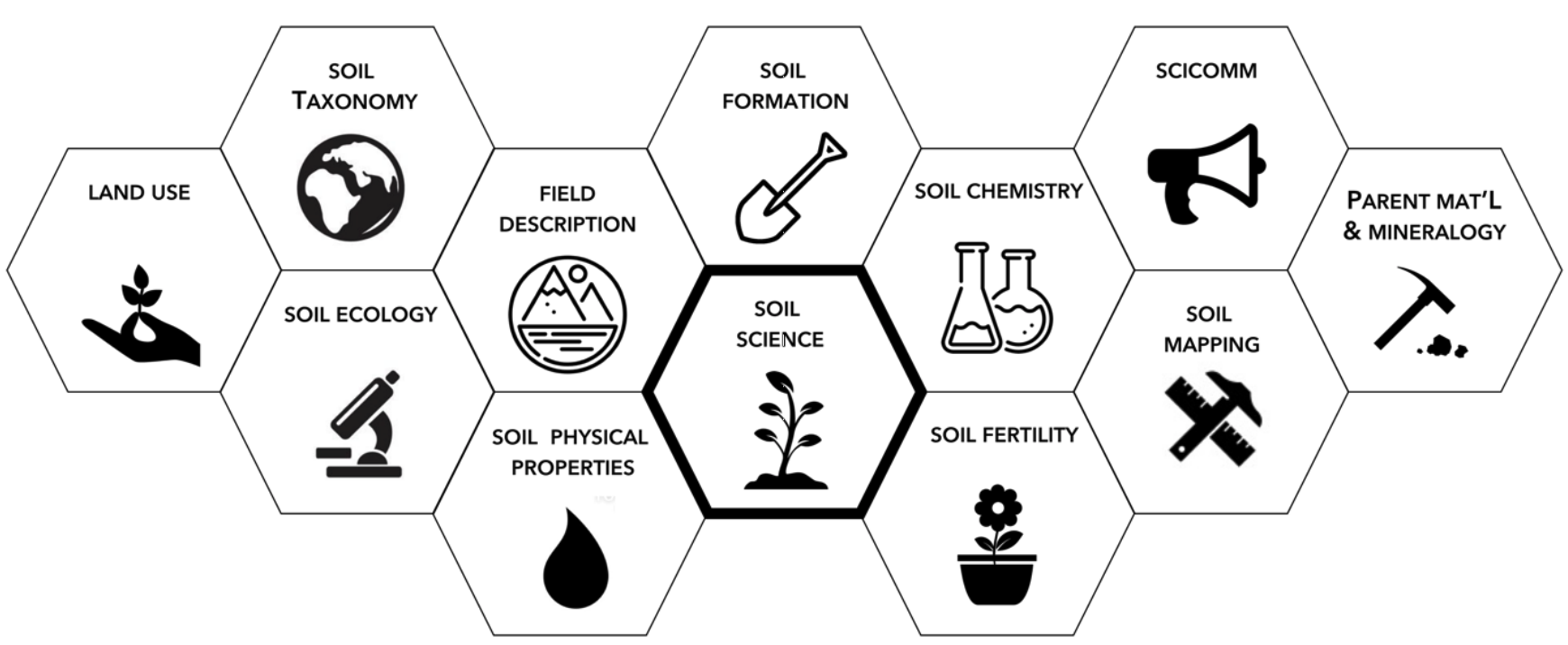
By nature of these sub-disciplines, soil science is inherently an interdisciplinary field. For this first lab, we will begin to learn a bit more about this interdisciplinary science by understanding the fundamentals of soil formation, soil characteristics, and the methods used for identifying and describing soils.
SOIL FORMATION
Soil is defined as: “a natural body comprised of solids (minerals and organic matter), liquid, and gases that occurs on the land surface, occupies space, and is characterized by one or both of the fol owing: horizons, or layers, that are distinguishable from the initial material as a result of additions, losses, transfers, and transformations of energy and matter or the ability to support rooted plants in a natural environment” (Keys to Soil Taxonomy, 2012).
Soils exist in three dimensions (pedon; 3 dimensional bodies) containing inorganic and organic material generally arranged into layers from the land surface downward into the earth. These layers of topsoil and subsoil (being roughly parallel to the ground surface) are called horizons. A two-dimensional vertical section of soil extending through these horizons downward to the parent material is called a profile.
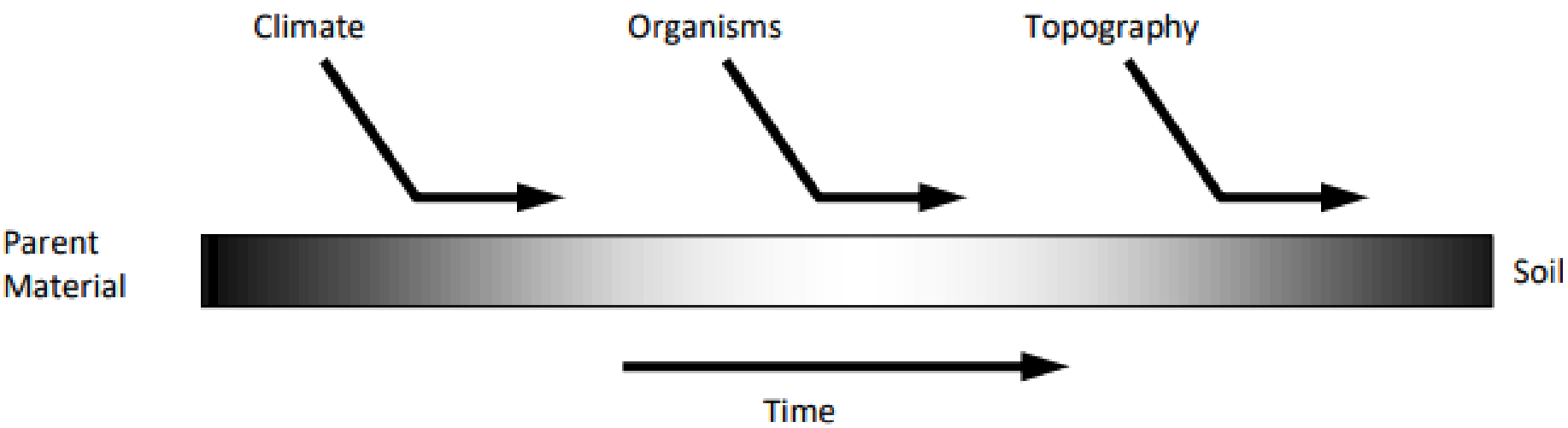
Soils form in place based on five natural soil forming factors, including: 1) Climate; 2) Organisms; 3) Relief; 4) Parent Materials; And, 5) Time (Figure 1). Collectively, these five factors contribute to the function of soil formation (S), S= f (Cl, O, R, P, T…), otherwise known as pedogenesis. As the diagram suggests, soil formation is a continuum. As any one factor or influence changes, the final soil product will vary. An infinite number of combinations of soil forming processes yield many different soil properties.
Understanding the role of each soil forming factor allows us to understand or predict soil occurrence.
These five soil forming factors also work through four important soil forming processes (Table 2), considered in the following four groups: 1) Additions; 2) Losses; 3) Transformations; And, 4) Translocations.
| Soil Forming Factor | Example |
|---|---|
| Climate | Temperature, precipitation, evaporation |
| Organisms | Vegetation, fauna, human influence |
| Relief | Slope, erosion/sedimentation, hillslope position |
| Parent Material | Mineralogy, bedrock, chemical species present, texture |
| Time | Change of boundary conditions |
|
Soil Forming Process |
Example |
|---|---|
| Additions | Organic matter, fertilizers, dust deposition, other mineral soil |
| Losses |
Movement of soil via wind or water, OR chemical compounds leached, eroded, or harvested from the soil |
| Transformations |
Chemical or physical weathering of soil particles or components |
| Translocations |
Movement of soil components (organic or mineral) between horizons within a soil profile |
While these factors and processes contribute to the natural formation of soil, it is also acknowledged that soil formation is likewise impacted by what is referred to as, “the human factor”. As such, we all play a part in the formation, conservation, and protection of soil. As we manipulate the earth's surface, we can either improve or degrade our quality of lives. Regardless of the effect, we become responsible for the stewardship of our land – and good land stewardship requires us to understand the properties and processes of soils.
SOIL MORPHOLOGY, PROPERTIES, and IDENTIFICATION
Soils form from parent materials, which are acted upon by the four basic soil forming processes aforementioned. These four processes aid in distinguishing soils from layers of materials deposited by geologic processes. The extent to which these four basic processes occur help differentiate soils.
Soil Horizons
The horizon is different from the layers above and below it in the same soil. In total, there are five major soil horizons, called master soil horizons, which are distinguishable by their color, composition, and other characteristics.
O horizon
An O horizon consists of organic material deposited on top of the mineral surface. Often, various stages of decomposition can be recognized, with fresh material at the surface and decayed material below.
Most soils do not have an O horizon or, at best, they have only a thin O horizon either because soil microorganisms rapidly decompose the organic material, or very little organic material is deposited on the soil surface due to a lack of vegetative growth. However, some forest soils may have an appreciable accumulation of organic matter as an O horizon. This may consist of broadleaf litter or more commonly as a thick layer of pine needles.
A horizon
The A horizon is the mineral horizon characterized by a dark color caused by an accumulation of organic matter (humus) mixed into the mineral soil. A horizons usually have high biological activity. A horizons can be leached of clay, but remain dark because of organic matter replenishment. Most soils have an A horizon. A few soils may lack an A horizon either because they are very young or they have been severely eroded.
E horizon
The E horizon is light in color compared to the A horizon above or B horizon below. The E horizon is the zone of maximum eluviation. Eluviation is the slow removal of fine clay and organic material by water percolating down through the soil. The E horizon is usually found in sandy soils receiving high rainfall under forest vegetation.
B horizon
The B horizon is the mineral horizon usual y occurring beneath an A or an E horizon and above a C
horizon. The B horizon is the zone of maximum illuviation. Illuviation is the process of accumulation of clay, iron or aluminum oxides, humus, or some combination of these materials weathered in place or leached by eluviation from the overlying horizons. Some soils lack a B horizon because they are too young for materials to have had time to move downward by percolating water flow.
C horizon
The C horizon is the layer of unconsolidated earth materials that exhibit the least evidence of physical disintegration, chemical decomposition and root development. The C horizon is weathered parent material from which the A, E, and B horizons can develop. The parent material for any horizon is the material from which that horizon developed.
R layer
The R layer consists of the underlying hard bedrock material. Granite, basalt, sandstone, and limestone are common examples of R layer material. R layers are not considered soil.
Subdivisions/Subscripts
In the field, the master soil horizons may be subdivided to note special soil features. Some of the most common features are the effects of plowing (Ap), the development of a new B horizon (Bw), water-logging (Bg or Cg), accumulation of carbonates (Bk) or clay (Bt), and soft rock parent material (Cr). An AB
symbol represents a horizon between the A and the B, which has some properties of each horizon.
Soil color
Color is one of the most important physical characteristics of soil. It can be used to differentiate among various soil horizons (layers of soil), to estimate organic matter content, to evaluate the soil drainage class, and to assess many other soil conditions. The Munsell Color System, as approved by the National Bureau of Standards, is used to identify soil color. The Munsell Color System has been developed internationally to describe any color anywhere. It has nothing to do, directly, with soil.
In the Munsell Color System, three component parts describe the colors: hue, value, and chroma (always designated in exactly this order). Hue is the spectral variable. Hue represents one of the dominant colors of the rainbow, for example, yellow or red. Value represents the relative darkness or lightness of the color. Chroma represents the purity, strength, or saturation of a color. Colors having zero chroma are gray to black.
A Munsell Color Book is used to identify soil color. The book's pages display chips of various colors, which are matched as closely as possible to the soil color in the field. Each page represents a different Hue. Common pages used for soil studies include 10R, 5YR, 10YR, and 2.5Y hues. The letter R represents Red and the letter Y represents Yellow. Red soils are common when iron oxides are abundant in the soil profile. The pages go from 2.5R (pink) and 5R (yel owish pink), both of which are seldom used, to 7.5R (reddish orange) to 10R (dark reddish orange; commonly associated with iron oxides). The hues, which consist of increasing amounts of yellow mixed with red, are designated as 2.5YR (brownish orange), 5YR (strong brown), 7.5YR (moderate brown), and 10YR (medium brown). As the red is eliminated, more yellow is emphasized with 2.5Y (light olive brown) and 5Y (moderate olive). For a few strongly flooded soils, which have no free oxygen gas, the colors are very dark blue, dark greenish, dull bluish gray, or black.
On each page of the Munsell Color Book, the value is listed in increasing numerical order from the bottom to the top of the page (vertical y). The lower rows at the bottom of the page have low values and are dark colored. The upper rows at the top of the page have higher values and are lighter colored.
The columns of color going from left to right (horizontally) give the chroma. The left columns (low chroma) represent gray or pale colors. The right columns (high chroma) are more deeply or brightly colored. Thus, a single hue has many combinations of a value and a chroma.
The Munsel Color Notation consists of the color name folowed by the sequence, hue, value/chroma (i.e. 5 YR 3/2). A brown soil is designated by the notation 10YR 5/3. The name of the color is found on the page facing the color chart.
Soil Texture
The solid portion of soils consists primarily of mineral particles (usually more than 95 % by mass) mixed with organic materials. These mineral particles are divided into coarse fragments greater than 2 mm in diameter (termed gravel), and finer particles less than 2 mm in diameter.
The fine particle fraction is further divided into arbitrary size classifications known as soil separates. The three soil separates are sand, silt, and clay. These three separates remain essentially constant during your lifetime in any given soil. The size classification of these soil separates is shown in Table 3.
| Particles |
Diameter (mm) |
|---|---|
| Sand | 2.0 to 0.05 |
| Silt | 0.05 to 0.002 |
|
Clay |
less than 0.002 |
Soil texture is defined by the relative proportion of sand, silt, and clay. Soil texture remains constant for any given soil during your lifetime. Because texture is limited to sand, silt and clay, other soil components, including water, air, organic matter, and inorganic materials larger than 2 mm, are excluded, although gravels and cobbles may be included as modifiers to the textural name. Texture applies only to mineral soils. Organic soils such as peat and muck, do not have texture.
Percentage is determined by multiplying the decimal fraction of two numbers by 100 %. The symbol % means “per cent” which can be translated mathematical y to mean “per” = to divide by the number, and “cent” = 100. Thus % means “divide by 100" which is the same as to multiply by (1/100). Thus, to multiply by 100 % is the same as multiplying by 100 x (1/100) which equals 1.0. Therefore, multiplying any decimal fraction by 100% does not change the value of the original decimal fraction because it is the same as multiplying by 1.0. Note, it is incorrect to multiply only by 100. The correct form is to multiply by 100%, not by 100 alone.
The percentages of sand, silt and clay are calculated from laboratory data according to the following definitions:
\[ \mathrm{\%Sand = \dfrac{mass\;(g)\;of\;sand}{mass\;(g)\;of\;sand+silt+clay}\times100 \%} \nonumber\]
\[ \mathrm{\%Silt = \dfrac{mass\;(g)\;of\;silt}{mass\;(g)\;of\;sand+silt+clay}\times100 \%} \nonumber\]
\[ \mathrm{\%Clay = \dfrac{mass\;(g)\;of\;clay}{mass\;(g)\;of\;sand+silt+clay}\times100 \%} \nonumber\]
Remember, percent (%) is defined as parts per hundred (pph).
Example: The following data were obtained about a soil sample:
mass of sand = 15.5 g
mass of silt = 17.0 g
mass of clay = 17.5 g
total mass of dry inorganic soil < 2 mm in diameter = 50.0 g
\( \%Sand = \dfrac{15.5\; g\;sand}{50.0\; g\; dry\; soil}\times100 = 31.0\% \) = 31.0 pph sand in soil
\( \%Silt = \dfrac{17\; g\; silt}{50.0\; g\; dry\;soil}\times100 = 34.0\% \) = 34.0 pph silt in soil
\( \%Clay = \dfrac{17.5\; g\; clay}{50.0\; g\; dry\;soil}\times100 = 35.0\% \) = 35.0 pph clay in soil
Soils having similar textures can be grouped into classes of soils having similar characteristics and behavior. Twelve soil textural classes are given in the textural triangle (Fig.2). The textural classes provide a way to express soil texture without referring specifically to the percentages of each separate.
When any two of the three percentages are known, the soil textural class can be determined from the triangle. This is why only two axes are required to plot the textural class for any given soil.
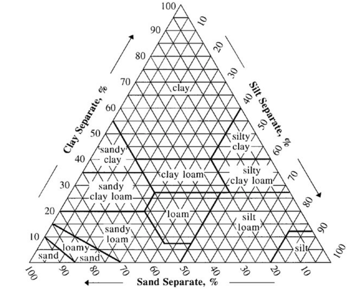
Locate the percent sand along the bottom (horizontal axis) of the triangle. Locate the percentage of clay along the left-hand axis of the triangle. Move upward from the sand percentage and to the right of the clay percentage until these two projected lines intersect. This point of intersection corresponds to the textural class corresponding to this particular portion designated on the triangle.
If a soil falls on the boarder of a texture (in-between textures), soil scientists have adopted the convention of adding 1% clay to the actual value and reporting the textural class name associated with this 1% clay addition. The reason for making this decision is based upon the fact the clay content is the most difficult to analyze of the three soil separates.
A soil's textural class may be determined by several methods that range from quick and simple field tests to more involved laboratory techniques. The "field" or “feel" method is the simplest to conduct, but it is the least accurate due to differences among individuals. The feel method is qualitative more than quantitative. The feel method involves moistening the soil, kneading the moistened soil mass with your fingers to mix the particles thoroughly, and feeling the particles to determine the texture. The accuracy of estimating soil texture by this method improves with experience. Examples of the soil textures using the feel method are provided in descriptive form.
Determining the Soil Textural Class by the "Feel/Field" Method
The soil textural class can be estimated by observing and feeling the soil under dry, moist, and wet conditions. The size range of the separates and their feel when moist are listed in Table 4.
|
Soil Separate |
Diameter (mm) |
Feel: moist condition |
|---|---|---|
| Sand | 2.0 – 0.05 | Gritty |
| Silt | 0.05 – 0.002 | Smooth, velvety, buttery |
| Clay | < 0.002 | Sticky, plastic |
Soil Structure
Soil structure is the arrangement of the individual soil particles into aggregates which are separated by surfaces of weakness. The structural aggregates, which are called peds, comprise several types depending on their shape: granular, blocky, prismatic, columnar, and platy. The definition has two parts: aggregation and separations. If a soil's condition does not satisfy both parts of the definition, it is structureless. Thus, not all soils have structure. The two structureless conditions are single grained (having no aggregation) and massive (having no separation patterns).
Granular soil structure… occurs most commonly in the A horizon. Granular structure forms as a result of the soil humus attracting strongly to the surface of the silt and clay particles of the soil. This attraction multiplied over many years creates aggregates. The binding between the humus of one aggregate and the next is less than the binding of the humus to the silt and clay particles. Consequently, the aggregates act independently. The humus causes the individual aggregates to arrange much as marbles would in a random arrangement with many voids or pore spaces between the aggregates. These pores allow for rapid water permeability. These same pores permit rapid air movement and allows for easy root penetration. Granular structure is optimized in the presence of the very fine roots of grasses. Granular structure can form within 50 to 100 years of exposing new parent material.
Blocky soil structure… is most commonly found in the B horizon. Blocky structure occurs as a result of the long, slow process of clay particles moving from the A horizon (eluviation) and leaching into the B horizon (illuviation). As these clay particles accumulate in the B horizon, they settle inside existing pores. Consequently, the soil pores become lined with these il uviated clay particles. With time, more of these pores become fil ed with clay, thus squeezing the pores tighter together and reducing water permeability, air movement and ease of root penetration. These individual aggregates take on a block-like appearance.
Prismatic soil structure… usually forms after blocky structure has been formed in the B horizon of a soil. Prismatic structure is usually associated with soils which have formed in semiarid and arid environments where the soil dries out to a considerable depth during some period of the year. This pul s the blocks apart and eventually leads to a whole group of blocks acting as a vertical prism. These prisms form zones of weakness between the prisms vertically. During the first rains of the wet season, water rapidly moves down along these prisms, but as the soil becomes wetter, the prisms expand, fil ing the voids between the prisms resulting in moderate water permeability. This causes restricted air movement and reduces the ease of root penetration through this horizon.
Columnar soil structure… occurs in the B horizon of some soils in semiarid and arid regions. Columnar structure only occurs where the soil has a high concentration of sodium on the soil cation exchange sites. The columns form in a similar manner to the formation of the soil prisms. However, as the soil continues to form, the sodium disperses the clays from the surface of the prism and causes these clays to move down the edges of the prisms. This causes a strong degree of sealing of the prisms resulting in slow to very slow water permeability, restricted air movement, and very difficult root penetration. Few plants can grow in such soil.
Platy soil structure… is relatively rare in native soils. Platy structure is most commonly formed as a result of compaction by vehicles, livestock, and humans. Platy structure is most commonly found in the A horizon of agricultural, urban, forest, and range soils under intensive management. The key factor is relatively horizontal layers of these soil aggregates.
Single grain soil structure… occurs where no grain is connected to any other grain. The best example is dune sand. Sands and silts in an alluvial (river deposit) or loess (wind deposit) may have a single grain structure. Single grain structure is a lack of structure since no true aggregates exist.
Massive soil structure… is really the lack of structure. As the term massive suggests, this is simply a mass of soil particles with no apparent repeating shape across the horizon. Massive structure usually occurs in the C horizon but may occur in other horizons if very little soil horizon development has occurred.
Soil structure is the second most important soil physical property. It influences water infiltration and percolation, aeration, erosion resistance, and ease of root penetration. The soil’s structure is controlled by the soil’s texture, organic matter content and form of organic compounds, plant and animal activity, and clay mineral content, and chemistry. Some common soil structure cementing agents are humus, aluminosilicate clay, iron and aluminum oxide clay, silica, and carbonates. Often, soil structure is easily altered by human activities such as tillage or compaction.
Soil structure and texture interact to control other soil properties. In Table 4, soil structure has a greater influence in fine textured soils than in coarse textured soils. This indicates structure is more prominent in fine soils than in coarse soils.