
2.5: Soils of the Atlantic Provinces
- Page ID
- 16617

Brandon Heung, Kevin Keys, David Burton, and Derek Lynch
Learning Objectives
On completion of this chapter, students will be able to:
- Understand the factors responsible for the distribution of soils in the Atlantic Provinces
- Identify the diagnostic soil horizons associated with soil orders and great groups (according to the Canadian System of Soil Classification) of the Atlantic Provinces
- Relate the major land uses of the region with the properties of the soils
INTRODUCTION
Seven of Canada’s ten soil orders can be found in Atlantic Canada, but high annual precipitation rates and a preponderance of relatively coarse, acidic glacial till parent material has led to Podzols being the dominant soil in the region. In many cases, these soils are also very stony and/or shallow to bedrock, which further limits their agricultural potential. As a result, the Atlantic provinces (New Brunswick, Nova Scotia, Prince Edward Island, and Newfoundland and Labrador) account for only about 1.5% of Canada’s agricultural land base (Statistics Canada, 2016), with forests covering the majority of land in the region. Although each province has locally important agricultural areas, only in Prince Edward Island does agricultural land dominate over forest land.
FACTORS CONTROLLING THE DISTRIBUTION OF SOILS IN THE ATLANTIC PROVINCES
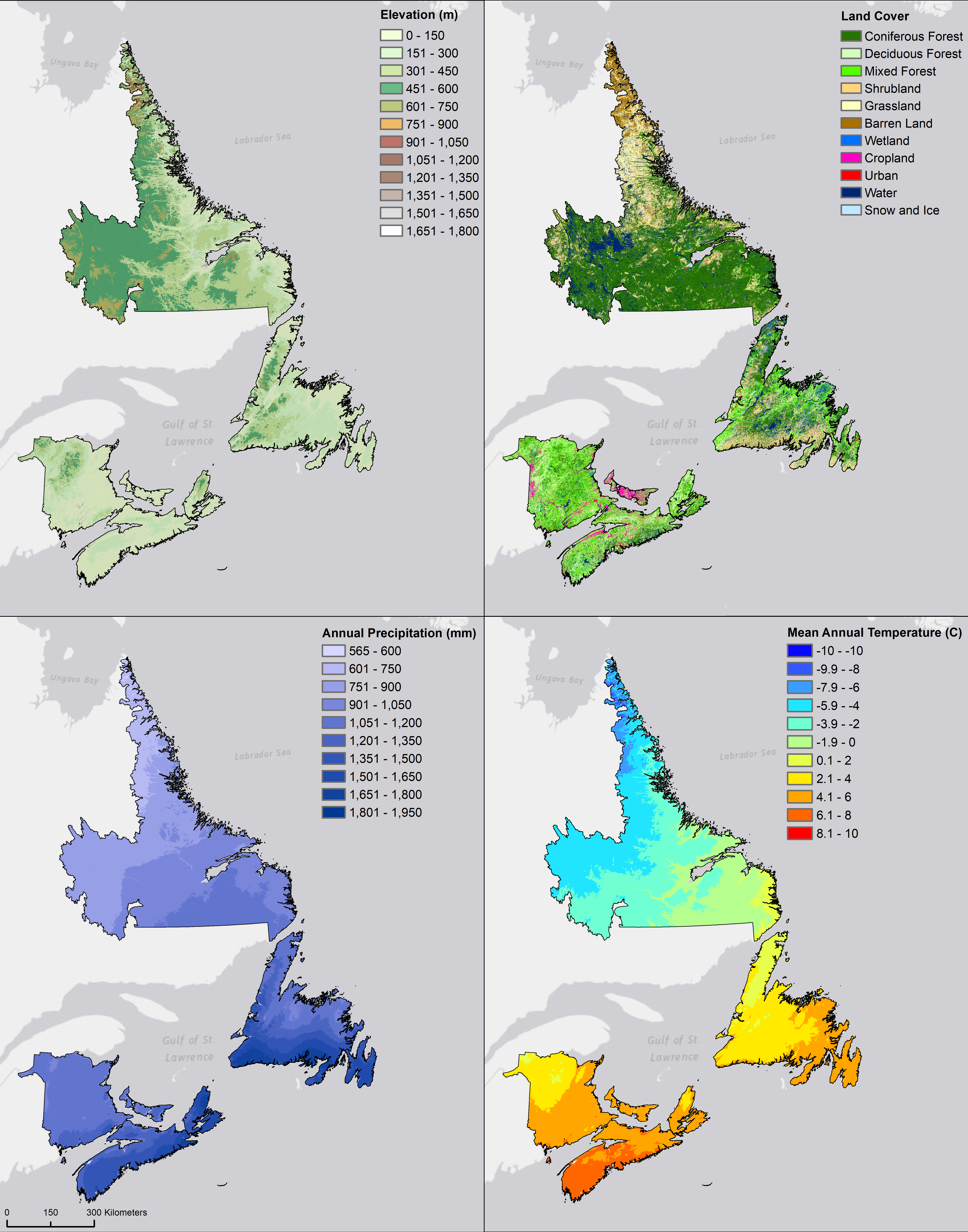
Using the National Ecological Framework for Canada, the Atlantic provinces can be divided into four ecozones (Ecological Stratification Working Group, 1996; Figure 13.1), which describe regions that share similar geology, vegetation, soil, and climate. New Brunswick, Nova Scotia, and Prince Edward Island are all situated within the southern-most Atlantic Maritime ecozone, with the island of Newfoundland fully covered by the Boreal Shield ecozone and Labrador primarily in the Taiga Shield ecozone (with inclusions of the Boreal Shield ecozone in the southeast and the Arctic Cordillera ecozone in the north).

Atlantic Maritime Ecozone
The climate of the Atlantic Maritime ecozone is largely influenced by its proximity to the Atlantic Ocean, which results in moist conditions and moderate temperatures (Figure 13.2). This ecozone receives an average 1250 mm of precipitation annually (range 970 to 1840 mm) and is the warmest in the region with an average annual temperature of 7°C (range 1 to 8°C) (Fick and Hijmans, 2017). Land cover is dominated by forests ranging from pure softwood, to mixedwood, to pure hardwood. Where site conditions do not limit growth, climax species include red spruce (Picea rubens Sarg.), eastern hemlock (Tsuga canadensis (L.) Carriere), eastern white pine (Pinus strobus L.), sugar maple (Acer saccharum Marsh), and yellow birch (Betula alleghaniensis Britton). In coastal areas and in higher elevations, balsam fir (Abes balsamea (L.) Mill.) and white spruce (Picea glauca (Moench) Voss) are more common. Bedrock geology is largely comprised of Paleozoic era formations (Figure 13.3) and are primarily sedimentary in nature; however, inclusions of volcanic and intrusive igneous rock are also common (Wheeler et al., 1997). Surficial geology is dominated by a variety of glacial till deposits, with glacio-fluvial deposits and rocky areas locally important (Figure 13.3).

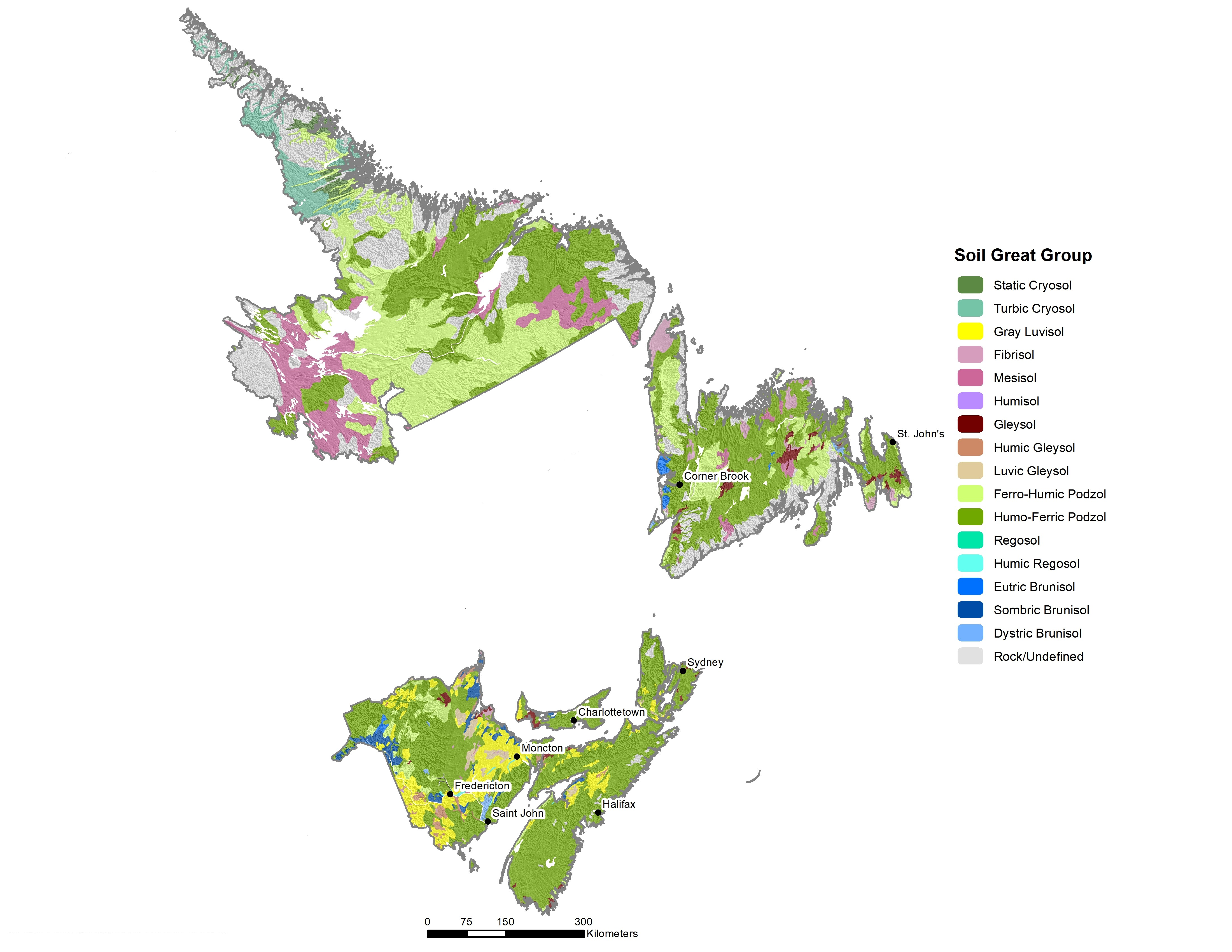
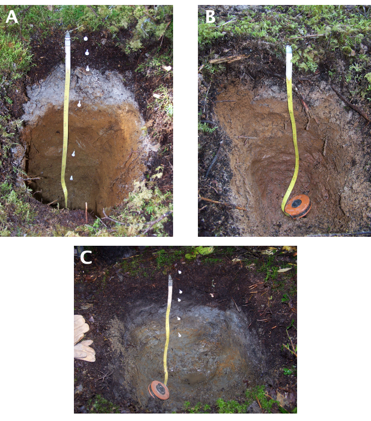
In terms of soils, Humo-Ferric Podzols with diagnostic Bf horizons are the most common and are typically formed at lower elevations with milder climates (Figs. 13.4 and 13.5). However, Ferro-Humic Podzols with diagnostic Bhf horizons are also frequently found, especially where cooler temperatures and higher moisture levels have contributed to greater soil organic matter accumulation. In addition, Gray Luvisols can be locally important and are somewhat unique in that they often exhibit a bisequal profile development where a Podzolic Bf forms over a clay-enriched Bt horizon (Figure 13.5). Dystric Brunisols with Bfj horizons can sometimes be found in less well-developed soils, while richer Sombric Brunisols with Ah and Bm horizons are locally important in parts of New Brunswick (Figure 13.4). Finally, with high precipitation and variable topography, poorly drained Gleysols (all great groups) and Organic soils (mainly Mesisols and Humisols) can be found scattered across the ecozone.
Boreal Shield Ecozone
The Boreal Shield Ecozone is by far the largest ecozone in Canada and extends from northern Saskatchewan to all of Newfoundland and southeastern Labrador (Figure 13.1). Although much of this ecozone is associated with a continental climate, proximity to the Atlantic Ocean results in generally warmer and moister conditions in Newfoundland and Labrador. This component of the ecozone receives on average 1230 mm of precipitation annually (range 800 to 1800 mm)—similar to the Atlantic Maritime ecozone (Fick and Hijmans, 2017; Figure 13.2). Precipitation is highest along the southern coast of Newfoundland and decreases along a northwestern track towards Labrador. Mean annual temperature is about 2°C with a range of -5 to 6°C (Fick and Hijmans, 2017).
Unlike the Atlantic Maritime ecozone, the Boreal Shield has far greater variability in terms of the type and age of the bedrock (Figure 13.3). The eastern-most region of Newfoundland is dominated by old sedimentary and volcanic rock from the Precambrian era that transitions westward to younger Paleozoic rock. In Labrador and parts of northern Newfoundland, bedrock consists mainly of Precambrian metamorphic and intrusive rock. As with other ecozones, surficial geology is mainly comprised of glacial till deposits of variable thickness, but with a larger proportion of thin veneer tills and exposed rock (Figure 13.3). In addition, glacio-fluvial deposits can be significant in some areas, such as with terrace landforms adjacent to the Churchill River in eastern Labrador. Land cover is dominated by boreal softwood forests [black spruce (Picea mariana (Mill.) Britton, Sterns & Poggenb.), balsam fir, white spruce, eastern larch (Larix laricina (Du Roi) K. Koch)] with some trembling aspen (Populus tremuloides Michx.) and white birch (Betula papyrifera Marshall). Newfoundland and Labrador also has extensive coverage of bogs, fens, and heathlands.
Soils in the Boreal Shield ecozone are dominated by moderate to coarse-textured Humo-Ferric and Ferro-Humic Podzols (Figures 13.4 and 13.6). Humic Podzols (with diagnostic Bh horizons) are also found in some areas. Gleyed Subgroups of these soils are quite common, with cemented Subgroups (e.g., Orsteins with Bfc or Bhfc horizons) also frequently found along the coast and in coarser-textured soils (Woodrow and Heringa, 1987). Fibrisols and Mesisols are associated with the widespread bog and fen landforms. High moisture levels, variable topography, and near-surface bedrock also promote development of poorly drained Gleysols which can be found scattered across this ecozone, as well as in concentrated areas in eastern and central Newfoundland (Heringa, 1981; Figure 13.4).
Taiga Shield and Arctic Cordillera Ecozones
The Taiga Shield ecozone is the main ecozone in Labrador and is the largest by area in the Atlantic region (Figure 13.1). At these latitudes, moderating effects of the Atlantic Ocean are offset by cold water currents from the north resulting in short, cool summers and long, cold winters (Ecological Stratification Working Group, 1996). The mean annual temperature is highest (1.5°C) along the eastern coast and decreases inland to -7°C. Average annual precipitation is 910 mm and ranges from 650 to 1250 mm. North of the Taiga Shield is the Arctic Cordillera ecozone (Figure 1). Here the average annual temperature is only -6°C (range -10°C to 0°C). In addition to being the coldest ecozone in the region, the Arctic Cordillera is the driest with an average annual precipitation of only 680 mm (range 560 to 910 mm). Both these ecozones are mainly underlain by Precambrian metamorphic and intrusive igneous rocks (gneiss and granite). Surficial geology is comprised of glacial till deposits of variable thickness, but with a large proportion of thin veneer tills and exposed rock in eastern and northern areas (Figure 13.3).
Land cover in the Taiga Shield ecozone is dominated by black spruce forests that can grade into stunted tuckamore in more exposed areas. At higher elevations and along the northern range of the ecozone, trees reach their habitat limits and the landscape transitions to alpine meadow and/or tundra vegetation (Ecological Stratification Working Group, 1996). Moving north, the Arctic Cordillera ecozone transitions to a landscape consisting of mainly tundra and exposed bedrock.
Humo-Ferric and Ferro-Humic Podzols are the dominant soils in the Taiga Shield ecozone, with significant inclusions of Organic Mesisols. In some areas, near-surface permafrost also results in the development of Organic Cryosols, while thin Organic Folisols can be found in association with bedrock exposures. Dystric Brunisols can also be found where soil development has been slowed by climate and/or age of parent material (e.g., younger colluvium deposits). Moving northward, near-surface permafrost becomes more extensive leading to development of both Organic and Turbic Cryosols. Turbic Cryosols show evidence of cryoturbation (y horizon suffix) where mineral horizons become disrupted, mixed, and/or broken through regular frost churning.
SOILS AND LANDUSE
Agriculture
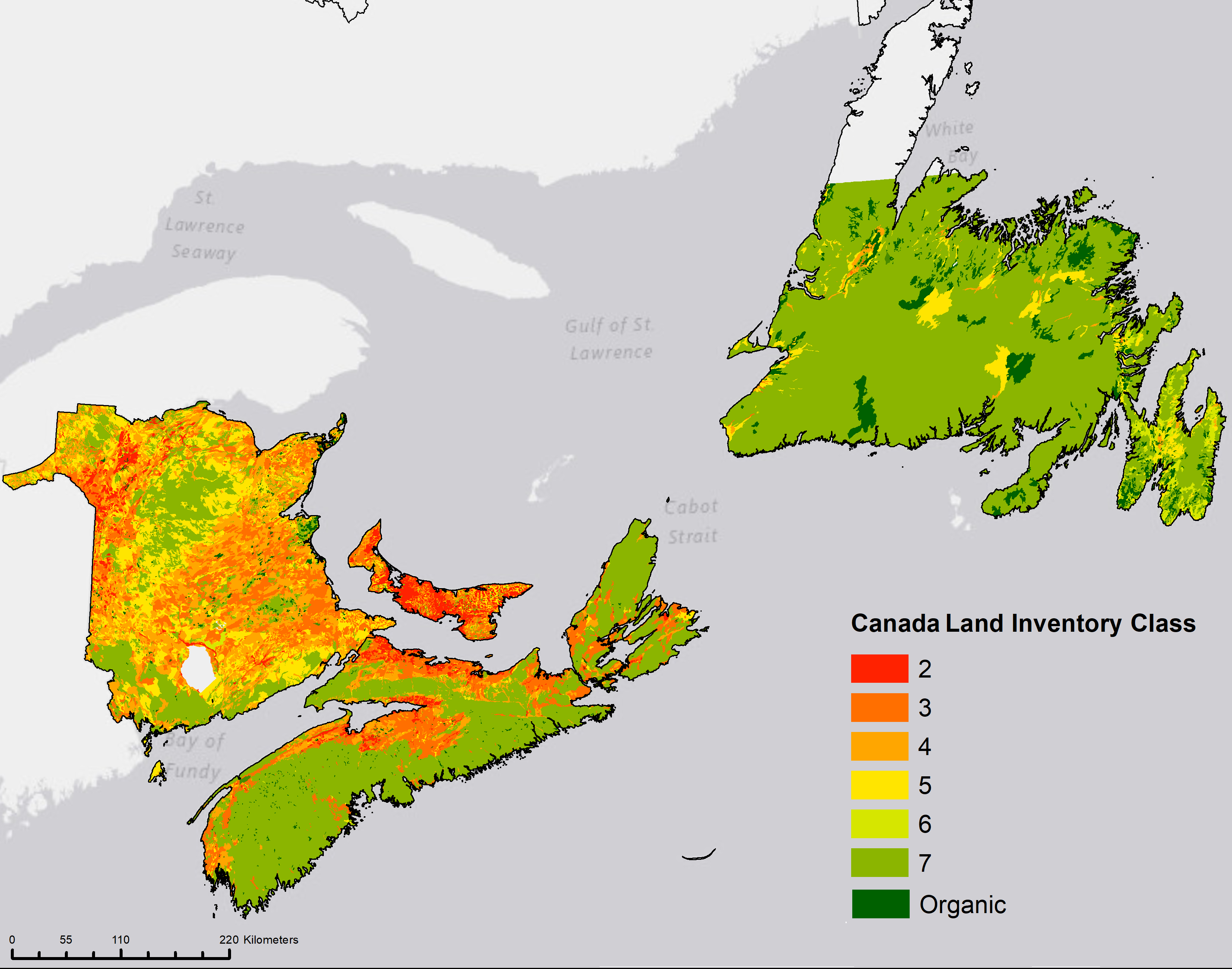
Throughout Atlantic Canada, the capability of agricultural lands is evaluated using the Canada Land Inventory (CLI; see Chapter 8, Canada Land Inventory). The CLI is based on a rating system ranging from 1 to 7 whereby soils are categorized based on their potential and limitations for agricultural use. In the CLI rankings, Classes 1 through 4 are considered to be capable of sustained use for cultivated field crops. In Class 1 land there are no significant constraints to crop growth while Class 2 lands experience moderate limitations and therefore require moderate conservation practices. In Class 3 and 4 lands, the range of crops is restricted and special management measures are needed to conserve the soil. Classes 5 and 6 are only suitable for forage production and are most commonly used for grazing of livestock.
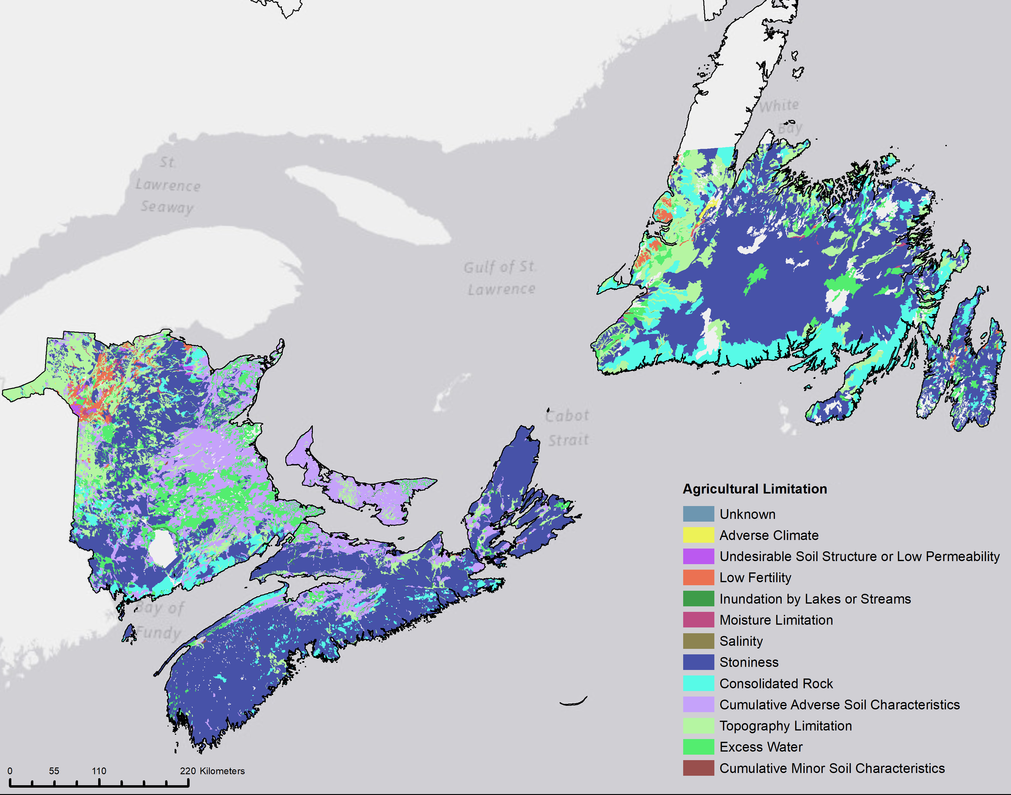
Within this region, there are no Class 1 lands (no significant limitations); furthermore, the distribution of Class 2 lands is limited to Prince Edward Island, northwestern New Brunswick, and the Annapolis Valley of Nova Scotia (Figure 13.7). Class 2 lands experience limitations due to climate in Prince Edward Island and Nova Scotia and low fertility in New Brunswick (Figure 13.8). Class 2 lands occupy approximately 588,000 ha of Atlantic Canada while Class 3 and Class 4 lands occupy approximately 2,275,000 ha and 2,507,000 ha, respectively. The majority of land in Nova Scotia and Newfoundland are Class 7 and are therefore not capable for arable culture or permanent pasture.
In 2011, Statistics Canada reported 1,063,747 ha of agricultural land in Atlantic Canada—a decrease of 12.8% from 30 years earlier (Clearwater et al., 2016). As of 2011, approximately 40% of the land was cropland; 10% was pasture; and the remaining 50% of the land included woodlots, wetlands and farmyards. From 1981 to 2011 there was a 56% decline in area for pasture and a 7% decline in other land uses with a corresponding 8% increase in cropland. Lower disturbance land management has declined (pasture -56%, forage -4%, and cereal grains -37%) and are being replaced by higher intensity cropping systems characterized by higher disturbance and/or low crop residue return to soil, (corn +145%, potatoes, +18%, soybeans increased from no reported area in 1981 to over 25,000 hectares in 2011). This transition from low disturbance, land use (pasture, woodland, wetland) and the reduced frequency of forages to more intensive cropland has resulted in significant impacts on soil health and soil microbial composition (Mann et al., 2019).
Soil organic matter is of critical importance in the function and resilience of the predominantly coarse textured soils of Atlantic Canada and is a primary indicator of soil health. The percentage of cropland in Atlantic Canada experiencing moderate (-25 to -90 kg ha-1 y-1) to large (> – 90 kg ha-1 y-1) decreases in soil organic carbon increased from 61% in 1981 to 83% in 2011. The decline in soil organic matter has been highlighted as a major concern in Atlantic Canada, particularly Prince Edward Island (Nyiraneza et al., 2017), where a province-wide network for soil quality monitoring as affected by landuse has been in place since 1998. Nitrogen additions have also increased to support the more intensive cropping practices. From 1981 to 2011 the percentage of crop land having very low to low residual soil nitrogen had decreased by 85% while land rated with a high and very high levels of residual soil nitrogen increased by 138%.
In 2016, an assessment of soil health was initiated by the Atlantic Soil Health Lab at Dalhousie University. The lab examined the role of land management, as reflected in cropping system, and pedogenic origin, as reflected in soil order, in influencing measures of soil health using the Cornell Soil Health Assessment framework. This protocol for assessing soil health was developed in New York state and combines the measurement of soil physical, chemical, and biological properties selected based on their relevance, sensitivity, consistency, and cost-effectiveness (Moebius-Clune et al., 2016). Land management explained a greater percentage of the variability in soil health parameters (average R2 = 23%) than did soil order (average R2 = 8%). In particular, parameters relating to organic carbon quantity or quality were more highly correlated to land management (R2 = 9 to 55%) than soil order (R2 = 2 to 12%). These results highlight the importance of soil management in impacting soil health and soil function.
Forestry
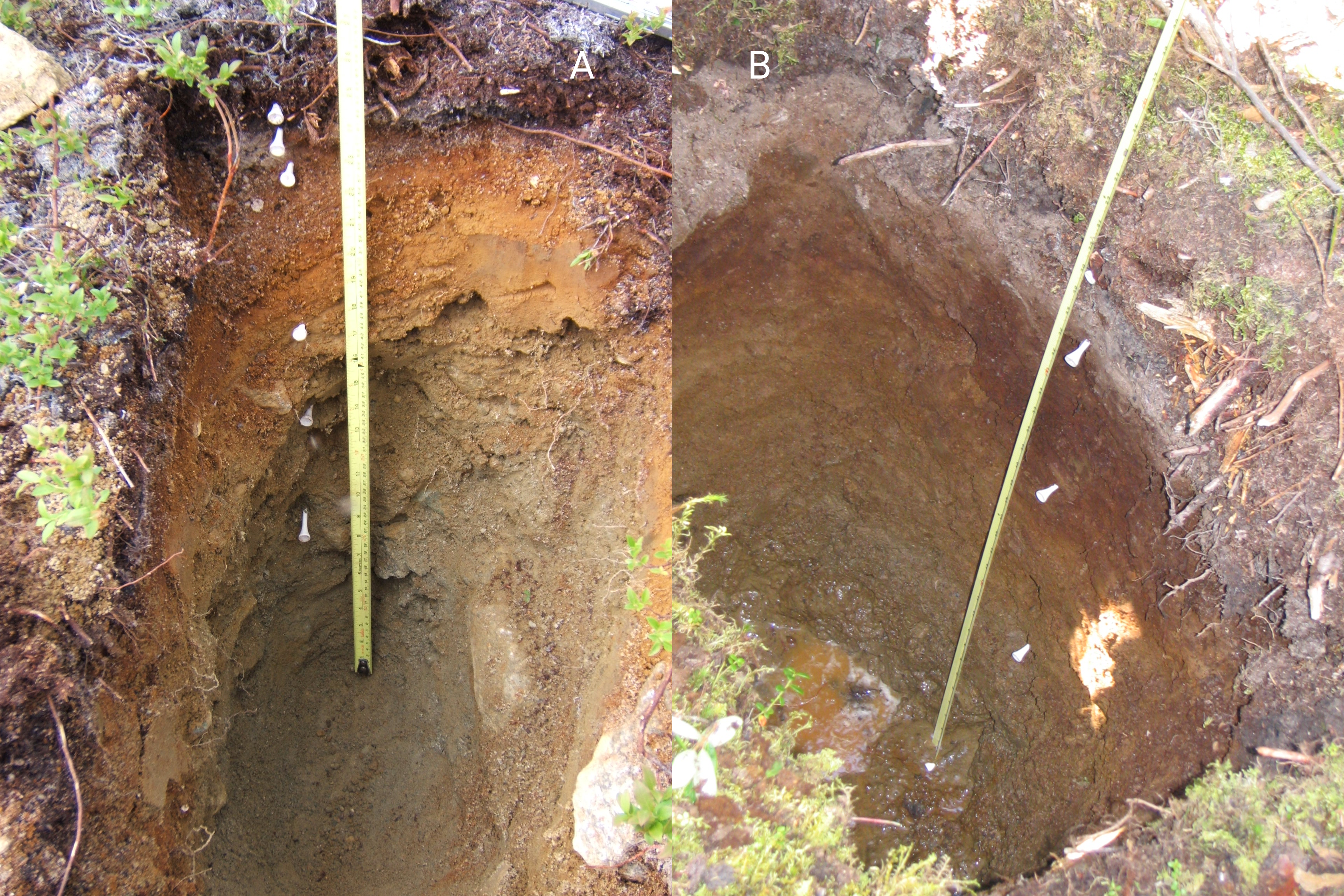
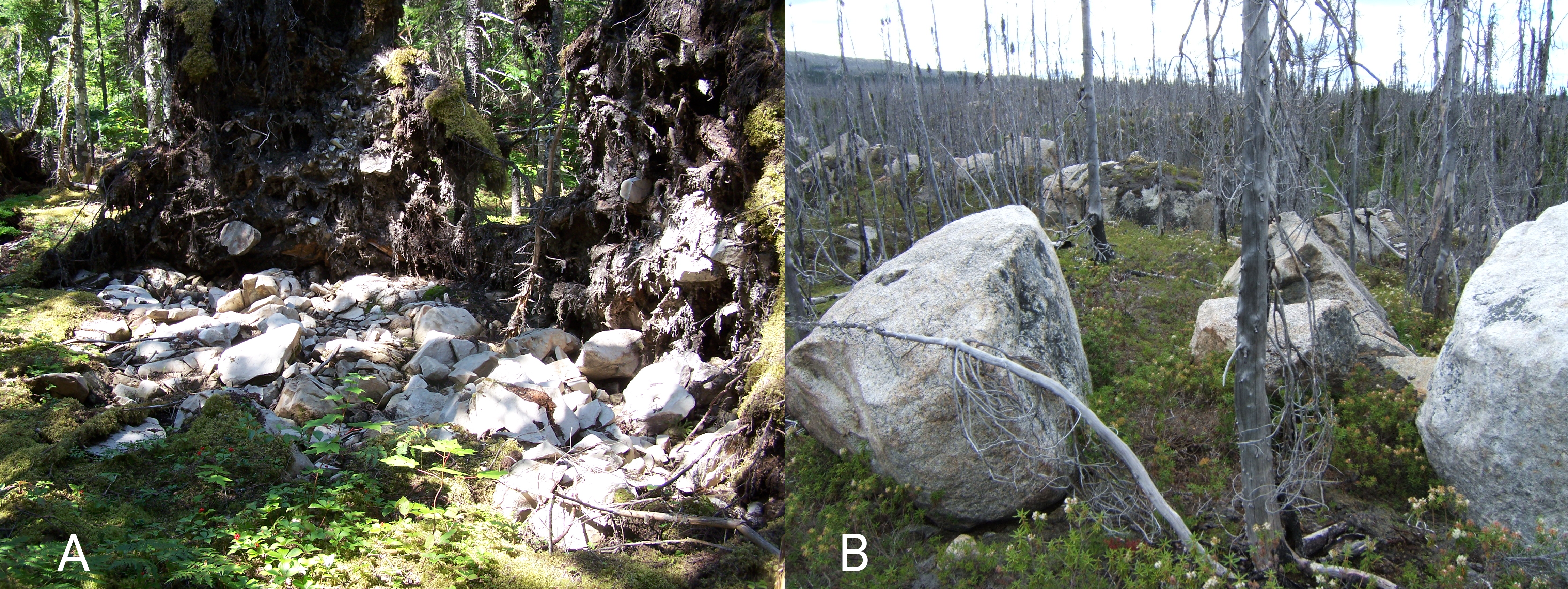
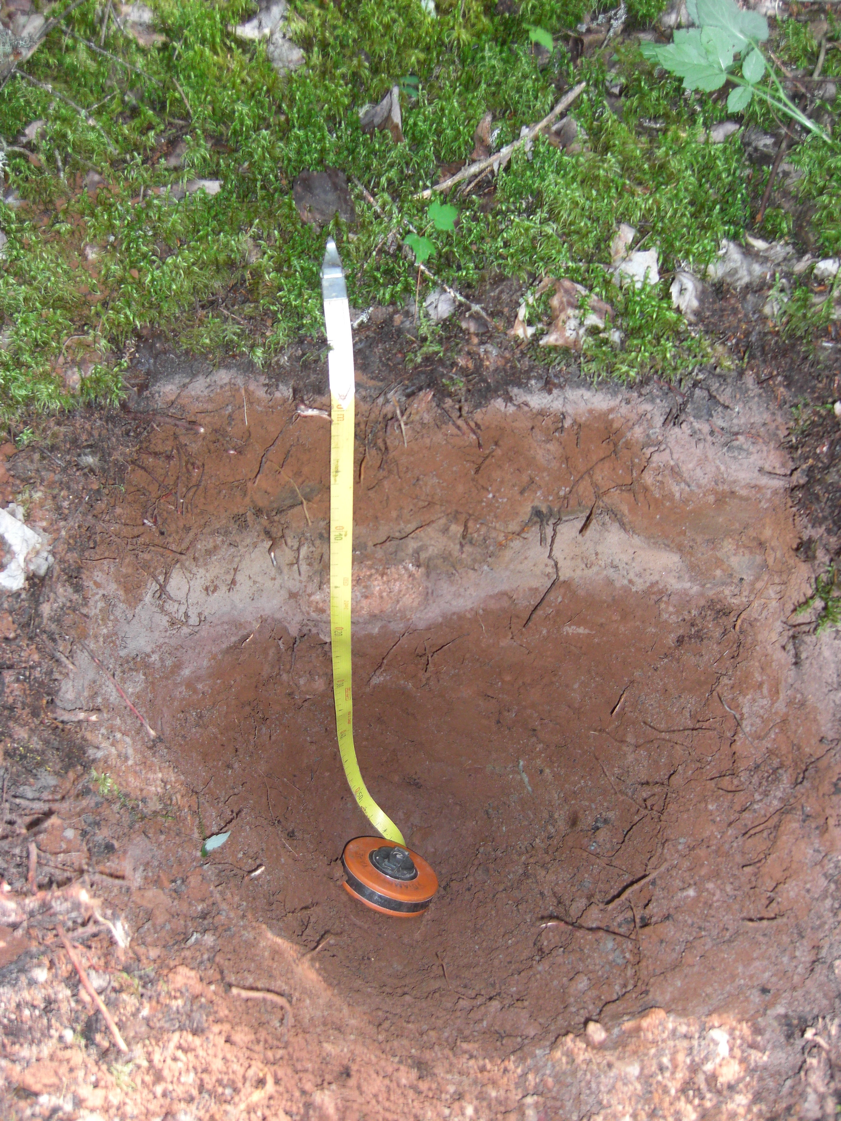
Forests in the Atlantic region have evolved in relation to local climate and soil/site influences. However, more temperate conditions in the Atlantic Maritime ecozone means that soils there have more influence on tree species distribution and potential productivity than is the case in the Boreal Shield and Taiga Shield ecozones where climate is the main driver. For example, sandy and/or very gravelly soils in the Atlantic Maritime ecozone tend to be associated with black spruce and pine species that are better adapted to dry, poor soils. These soils are typically Humo-Ferric Podzols and can sometimes be cemented. More loamy soils with higher fertility support a greater mix of tree species and tend to have a higher proportion of Ferro-Humic Podzols. Gray Luvisols have the potential to be very productive forest soils, but poor aeration and/or drainage problems often restrict potential growth and species mix. Shallow or stony soils in all ecozones can limit potential productivity and increase windthrow hazard, while surface boulders can reduce machine trafficability (Figure 13.9). Periodic windthrow disturbance in deeper soils can lead to mixing of soil horizons and create buried horizons which influence soil development (Figure 13.10).
Can You Dig It!
In the 1700’s Acadian French settlers, through the construction of dykes, land forming and a drainage network combined with hand-made aboiteaux (or sluice gates) to evacuate the drainage water, generated extensive (over 33,000 ha) farmland landscapes from reclaimed tidal salt marshes in Atlantic Canada. Dominated by the ‘Acadia’ soil series (Regosol order), these new soils show little horizon development and are characteristically flat, silt loam to silty clay loams, imperfectly drained, and subject to periodic flooding and saturated conditions. As relatively fertile soils, Acadia soils have been used for centuries for forage production, and also more recently for silage corn and soybean production. In 2012, the over 1300 ha of reclaimed marshland landscape at Grand Pre in the Minas Basin in Nova Scotia, the best example of such a historically transformed marshland or ‘polder’ landscape in North America, was recognized as a UNESCO World Heritage site (https://whc.unesco.org/en/list/1404).
SUGGESTED READING
Detailed information on the major soil orders and great groups for the Atlantic Region may be found in the following references:
Bedard-Haughn, A. 2011. Gleysolic soils of Canada: Genesis, distribution, and classification. Can. J. Soil Sci. 91: 763-779.
Kroetsch, D.J., Geng, X., Chang, S.X. and Saurette, D.D. 2011. Organic soils of Canada: Part 1. Wetland Organic soils. Can. J. Soil Sci. 91: 807-822.
Lavkulich, L.M. and Arocena, J.M. 2011. Luvisolic soils of Canada: Genesis, distribution, and classification. Can. J. Soil Sci. 91: 781-806.
Sanborn, P., Lamontagne, L., Hendershot, W. Podzolic soils of Canada: Genesis, distribution, and classification. Can. J. Soil Sci. 91: 843-880.
Tarnocai, C. and Bockheim, J. 2011. Cryosolic soils of Canada: Genesis, distribution, and classification. Can. J. Soil Sci. 91: 749-762.
REFERENCES
Agriculture and Agri-Food Canada. 2013. ISO 19131 Canada Land Inventory (CLI) – Data Product Specification. Science and Technology Branch, Agriculture and Agri-Food Canada. pp.28.
Canada Centre for Remote Sensing (CCRS), Earth Sciences Sector, Natural Resources Canada, Comisión Nacional para el Conocimiento y Uso de la Biodiversidad (CONABIO), Comisión Nacional Forestal (CONAFOR), Insituto Nacional de Estadística y Geografía (INEGI), and U.S. Geological Survey (USGS). 2015. North American Land Change Monitoring System (NALCMS) Collection, Commission for Environmental Cooperation.
Clayton, J.S., Ehrlich, W.A., Cann, D.B., Day, J.H., and Marshall, I.B. 1977. Soils of Canada Volume 1. Research Branch, Canada Department of Agriculture, Ottawa. pp. 243.
Clearwater, R.L., Martin, T., and Hoppe, T. 2016. Environmental Sustainability of Canadian Agriculture (Report #4). Agri-Environmental Indicators Report Series. Agriculture and Agri-Food Canada, Ottawa, ON.
Colpitts, M.C., Fahmy, S.H., MacDougall, J.E., Ng, T.T.M., McInnis, B.G. and Zelazny, V.F. 1995. Forest Soils of New Brunswick. Agriculture and Agri-Food Canada & Natural Resources Canada. pp. 51.
Earth Observation Research Center and Japan Aerospace Exploration Agency. 2019. ALOS Global Digital Surface Model (DSM), ALOS World 3D-30m Version 2.2 Product Description. pp. 12.
Ecological Stratification Working Group. 1996. A National Ecological Framework for Canada. Research Branch, Agriculture and Agri-Food Canada, Ottawa. pp. 125.
Fick, S.E. and Hijmans, R.J. 2017. WorldClim 2: new 1-km spatial resolution climate surfaces for global land areas. Int. J. Climatol. 37: 4302-4315.
Fulton, R.J. 1995. Surficial Materials of Canada. Geological Survey of Canada, Natural Resources Canada, “A” Series Map 1880A.
Heringa, P.K. 1981. Soils of the Avalon Peninsula, Newfoundland. Report No. 3, Agriculture Canada. pp. 117.
Mann, C., Lynch, D.H., Fillmore, S., and Mills, A. 2019. Relationships between field management, soil health and microbial community composition. Appl. Soil Ecol. 144: 12-21.
Moebius-Clune, B.N., Moebius-Clune, D.J., Gugino, B.K., Idowu, O.J., Schindelbeck, R.R., Ristow, A.J., van Es, H.M., Thies, J.E., Shayler, H.A., McBride, M.B., Kurtz, K.S.M., Wolfe, D.W., and Abawi, G.S. 2017. Comprehensive Assessment of Soil Health: The Cornell Framework, 3rd ed. Cornell University, Ithaca, NY.
Nyiraneza, J., Thompson, B., Geng, X., He, J.X., Jiang, Y.F., Fillmore, S., and Stiles, K. 2017. Changes in soil organic matter over 18 yr in Prince Edward Island, Canada. Can. J. Soil Sci. 97: 745-756.
Rees, H.W., Fahmy, S.H., Wang, C. and Wells, R.E. 2005. Soils of Central and Northern New Brunswick. New Brunswick Soil Survey Report No. 12, Agriculture and Agri-Food Canada. pp. 137.
Soil Classification Working Group. 1998. The Canadian System of Soil Classification Version 3. Agriculture and Agri-Food Canada. pp. 187.
Soil Landscapes of Canada Working Group. 2010. Soil Landscapes of Canada Version 3.2. Agriculture and Agri-Food Canada.
Statistics Canada. 2016. Table 32-10-0153-01: Total area of farms and use of farm land, historical data. https://doi.org/10.25318/3210015301-eng.
Wheeler, J.O., Hoffman, P.F., Card, K.D., Davidson, A., Sanfrd, B.V., Okulitch, A.V. and Roest, W.R. 1996. Geological Map of Canada. Geological Survey of Canada, Natural Resources Canada, “A” Series Map 1860A.
Woodrow E.F. and Heringa, P.K. 1987. Pedoclimatic Zones of the Island of Newfoundland. Report No. 32, Canada Soil Survey. pp. 12.
About the Authors
Brandon Heung, Assistant Professor, Department of Plant, Food, and Environmental Sciences, Faculty of Agriculture, Dalhousie University

Dr. Brandon Heung is an assistant professor in soil science and geographical information systems (GIS) in the Department of Plant, Food, and Environmental Sciences. His research is in the area of pedometrics—a subdiscipline of soil science that integrates soil science, GIS, remote sensing, spatial statistics, and machine-learning to better understand that spatial and temporal patterns of soil. He has been developing digital soil maps for applications in agriculture and forested systems and he is also interested in understanding how predictive digital soil models may be used to address climate change and food security issues.
Kevin Keys, Nova Scotia Department of Lands and Forestry
I have spent many years assessing, classifying, and interpreting soils across Canada from British Columbia to Labrador. However, most of my experience has been in Nova Scotia where I helped develop a forest ecosystem classification system focusing on soils and ecosite components. I am currently a soils specialist with the Nova Scotia Department of Lands and Forestry and I lead the Site Productivity Group within the Research and Planning Section. It’s my job to conduct research and develop management tools and guidelines that help promote forest soil health and sustainable forest management in the province.
David L. Burton, Professor, Department of Plant, Food, and Environmental Sciences, Faculty of Agriculture, Dalhousie University
Dr. David Burton is a Soil Scientist and Professor in the Department of Plant, Food, and Environment, Dalhousie University. His research examines the role of the soil environment in influencing the nature and extent of microbial metabolism in soil. His focus has been on processes in the cycling of nitrogen in soils and their implications for soil fertility and environmental impact. It is the aim of this work to better understand the factors that control soil microbial function and to use this information to developing resilient land management systems in response to a changing climate.
Derek H. Lynch, Professor, Department of Plant, Food, and Environmental Sciences, Faculty of Agriculture, Dalhousie University

Derek H. Lynch is Professor of Agronomy and Agroecology in the Department of Plant, Food and Environmental Sciences in the Faculty of Agriculture at Dalhousie University. From 2005-2015 he held the position as Canada Research Chair in Organic Agriculture. He teaches courses on soil science, agroecology, organic field crop management and urban agriculture. His research examines how farming system or field management practice impacts crop productivity and nutrient dynamics, while also exploring their influence on soil organic carbon dynamics, soil health and the diversity and functioning of the soil biota.