
2.1: Soils of British Columbia and Yukon- The Western Cordillera
- Page ID
- 16613

Les Lavkulich
- On completion of this chapter, students will be able to:
- Describe the geologic history of British Columbia and Yukon
- Identify factors responsible for soil distribution in the region
- Relate the major land uses of the region to soil properties
INTRODUCTION
British Columbia and Yukon are the most diverse areas of Canada in terms of geologic history, physiography, climate, biologic species and land use (Valentine et al., 1978). The diversity in environmental conditions is the result of the geologic history of the region and the complex pattern of mountain chains and valleys that resulted from the Earth-building forces (Figure 9.1). This diversity in environmental conditions in turn results in the greatest diversity of soils in Canada.
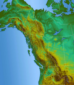
Most of British Columbia and Yukon are located in the Pacific Cordillera, a mountain chain (or cordillera) extending for a distance of over 6,000 km along the western side of North America, from Mexico to Alaska. Also known as the North American Cordillera or Western Cordillera, the Pacific Cordillera includes parts of Alberta and the Northwest Territories, including the Rocky and Coast Mountains. It is characterized by landscapes of mountains, isolated valleys, broad plateaus, and coastal islands. This complex topography contributes to topographically induced climate zones and a complex assemblage of vegetation types (Scudder, 1997), resulting in four major terrestrial ecozones (Taiga Cordillera, Boreal Cordillera, Montane Cordillera, and Pacific Maritime).
GEOLOGIC HISTORY
Located on the Pacific Ring of Fire, a zone characterized by active volcanoes and earthquakes, the western Cordillera is the result of the contact of the Cascadia subduction zone, that extends from Vancouver Island to northern California, and the Juan de Fuca, and North American tectonic plates (Monger and Price, 2002).
The Pacific Cordillera is the youngest of the three geologic regions in western Canada and is known for frequent earthquakes and sporadic volcanic eruptions (Figure 9.2). A series of crustal collisions, volcanic episodes, and periods of metamorphism formed the complex landscapes of the Cordillera (Monger and Price, 2002). The geologic history has resulted in a wide range of bedrock formations that include igneous, sedimentary, and metamorphic rocks, and resulted in a variety of mineral and other exploitable resources, notably copper, asbestos and abundant coal and fossil fuel deposits. Although there are hundreds of volcanic fields and centres in British Columbia, there are only 18 true volcanoes. The largest group is located in the north near the coast, while others are scattered throughout the province (Figure 9.2). The largest and most persistent volcanoes are the Mount Edziza complex and Level Mountain in northwestern British Columbia, which have had volcanic activity for millions of years. The Mount Edziza volcanic complex had about 20 eruptions over the past 10,000 years, with the most recent eruption in Canada in 1904 (Souther, 1992). The Mount Edziza volcanic complex was designated as a provincial park in 1972 to protect the volcanic landscape. Another relatively recent eruption was in the 18th century, when the Tseax Cone erupted killing over 2,000 people due to the toxic volcanic gases released during the eruption (Williams-Jones et al., 2019).
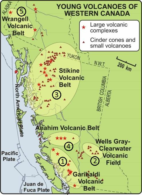
In the Yukon, there are more than 100 volcanoes that have been active during the Quaternary period (covers 2.58 million years ago to present). Around 800 AD, Mount Churchill near the Alaska-Yukon border erupted and the ejected ash, covering a large part of the Yukon Territory. The ejected ash, or tephra, is known as the ‘White River Ash’ (Reuter et al., 2020). The layers of volcanic ash deposits may still be seen in the soils throughout the central and southern Yukon (Dampier et al., 2011; Preece, et al., 2014).
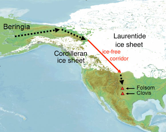
The Cordillera region was almost entirely covered by ice during the Pleistocene glaciation that extended from the coastal mountains in Alaska, south to the Yukon and British Columbia (Figure 9.3). Glaciation resulted in a lowered global sea level, including the formation of the Bering land bridge, which linked Asia with North America creating the ice-free Beringia region. The St. Elias Mountains interrupted and prevented ice sheets from forming in Beringia. Thus, the west-central and northern Yukon remained ice-free. This cold and arid grassland was the home to woolly mammoth, horses and lions (MacDonald et al., 2012).
SOIL DISTRIBUTION
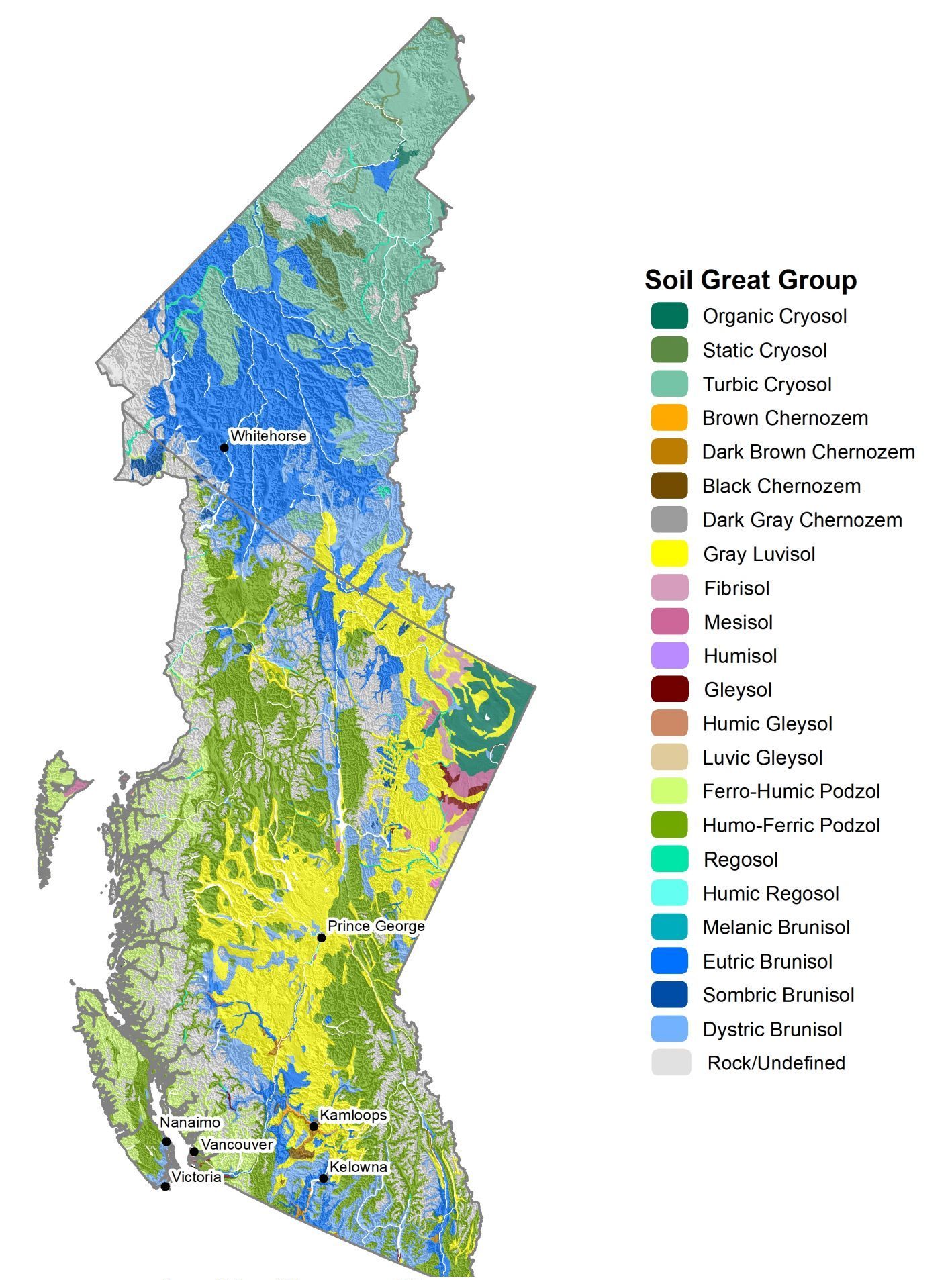
The soils of British Columbia and Yukon include all ten of the soil orders recognized by the System of Soil Classification for Canada (Figure 9.4). This remarkable diversity reflects the wide range of soil forming factors (time, parent material, climate, biota, topography and human activity) contributing to soil formation.
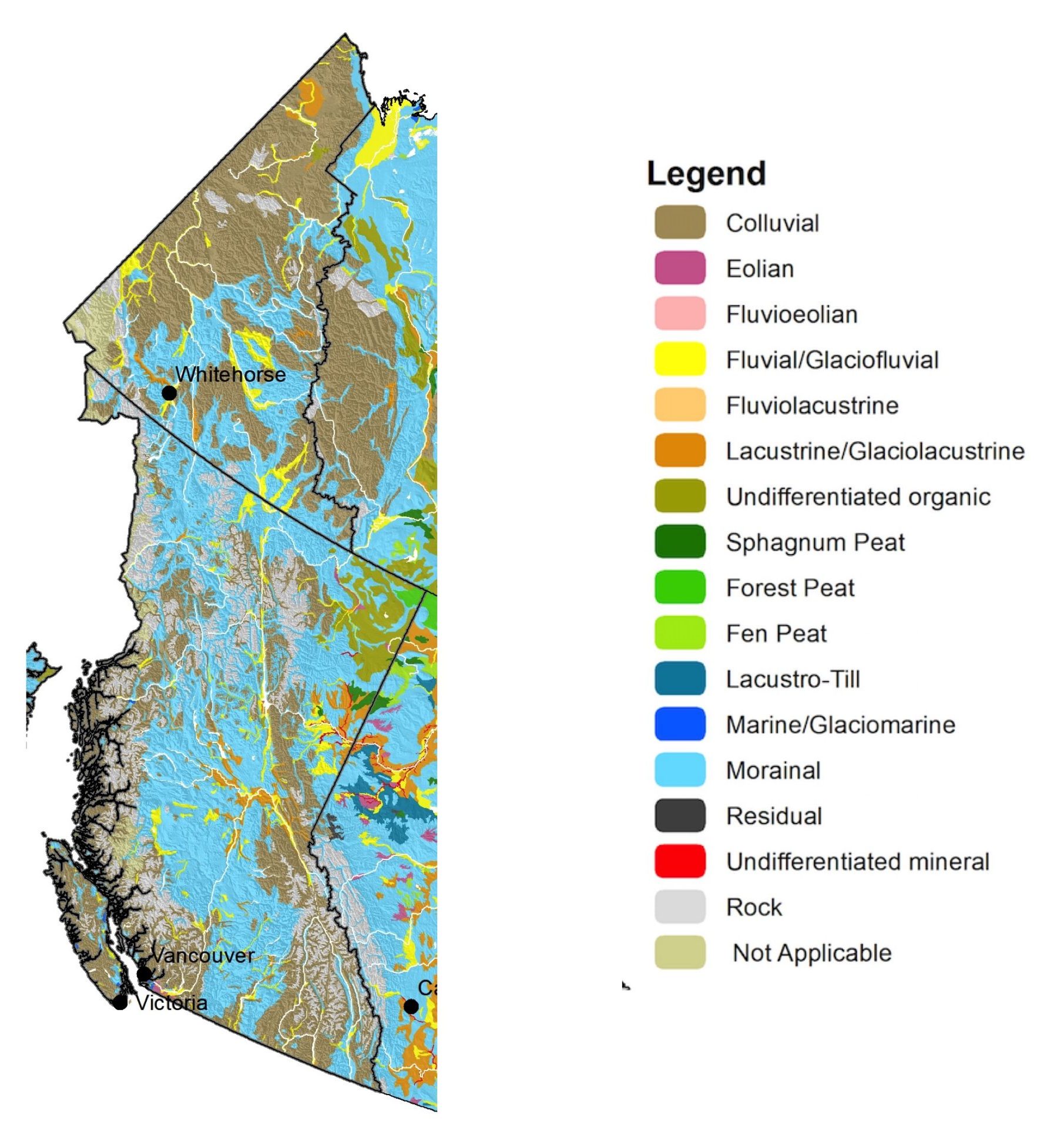
The complex geological and glacial history contributed to a complex pattern of soil parent materials. Parent materials range from present-day alluvium, colluvium and marine sediments, to organic deposits, and a complete suite of morainal (glacial drift) deposits, residual, bedrock, and mine wastes of tailings and rock dumps (Figure 9.5).
The particle size and chemistry of colluvial and morainal parent materials are largely inherited from the bedrock from which the parent material originated. The bedrock formations of British Columbia and Yukon have examples of all three general classifications of rock types – igneous, sedimentary and metamorphic (see Chapter 2). The Coast Mountains are predominately interlocking igneous and metamorphic rocks ranging from granites and granodiorites to basalts, schists and gneisses, while the eastern perimeter is primarily folded and faulted sedimentary shales, limestones and sandstones. The interior mountains and plateaus are dominated by a complex of sedimentary, metamorphic, volcanic and scattered igneous intrusions.
Climate also influences the pattern of soil distribution, and is most strongly controlled by the mountain chains within the Cordilleran region. The mountain chains control the pattern of precipitation, with generally wetter conditions on the western slopes and drier conditions on the eastern slopes and in intermontane valleys. A dominant north-south temperature pattern is typical along with altitudinal temperature gradients in the mountain chains. These climatic patterns strongly influence the pattern of vegetation distribution; hence, the Western Cordillera contains both the most desert-like vegetation assemblages and the wettest rainforest in Canada, within four major terrestrial ecozones (Taiga Cordillera, Boreal Cordillera, Montane Cordillera, and Pacific Maritime)
Biota is a soil forming factor that exerts a strong influence on soil distribution. The pattern of forest, tundra, grassland, and rockland distribution in British Columbia and Yukon varies greatly and is controlled by the impact of the mountain chains on weather patterns and climate. Interestingly, there is far greater diversity of plant species within the forests of this region than in comparable areas of the boreal forest or in the Prairie region (Andrews et al., 2019).
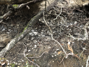
Human activities within the region reflect the diversity of soil types in the Western Cordillera. An interesting example of the impact of human activity of soil formation can be found at the Gulf Islands in British Columbia. Prolonged use by the Indigenous Peoples over thousands of years led to formation of unique anthropogenic soils from the Neptune soil series (Figure 9.6). These soils consist of shallow gravelly loamy sand to gravelly sand marine deposits mixed with clam and oyster shells, organic debris, and sometimes human artifacts. They are characterized by high calcium carbonate content from the shells, which prevents any significant profile development as indicated by the absence of a B horizon. Other examples of the impacts of human activity on soil formation in the Western Cordillera date to the period of European settlement and introduction of mining activities, beginning with the famous Klondike (1847) and Cariboo (1858) gold rushes, followed by extensive mining of asbestos and metals—notably copper, iron, and molybdenum—and fossil fuels (Levenson, 1992). One legacy of these activities is the presence of the large areas of mine spoil landscapes with fresh, human-derived “parent material” that provide challenges for ecological restoration.
The interactions among the various factors affecting soil formation (see Chapter 2) are reflected in Canada’s terrestrial ecozones (Figure 9.7). The ranges within the soil forming factors for the ecozones found in BC and Yukon are presented in Table 9.1.
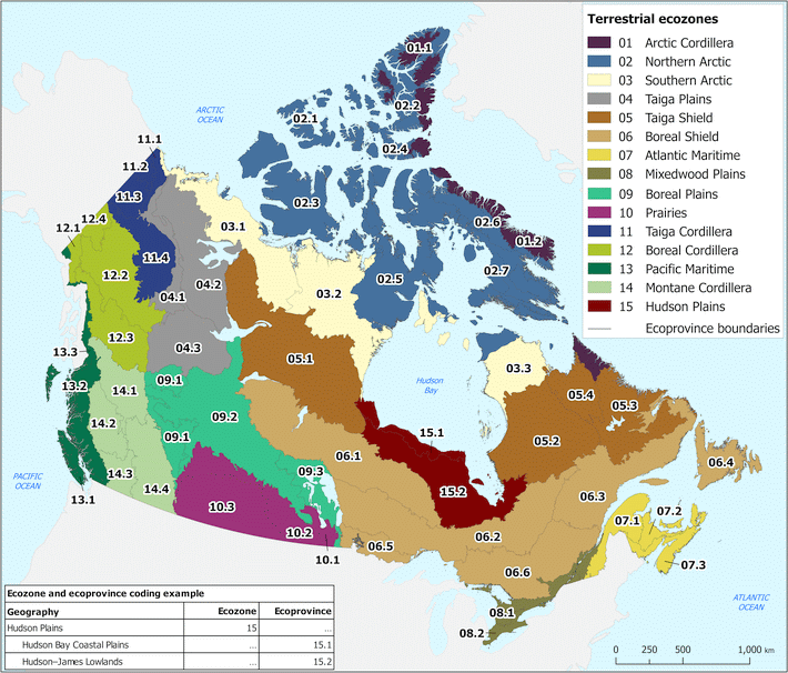
Table 9.1. Major climate, vegetation, parent material, topography, and soil attributes of the Taiga Cordillera, Boreal Cordillera, Pacific Maritime, and Montane Cordillera ecozones. Text is abstracted from Ecological Stratification Working Group (1996).
| Taiga Cordillera Ecozone | |
|---|---|
| Climate | Annual precipitation ranges from less than 300 mm in the north to more than 700 mm in the southeast. Mean annual temperatures range from -10°C in the north to -4.5°C in the south. |
| Vegetation | Natural vegetation ranges from arctic tundra in the north, to alpine tundra at higher elevations, and taiga or open woodland in the south (white spruce and white birch), mixed with medium to low shrubs, mosses, and lichens. |
| Topography | Steep, mountainous topography, consisting of repetitive, sharply etched ridges and narrow valleys, predominates with foothills and basins also present. |
| Bedrock and Parent Materials | The bedrock is largely sedimentary in origin with minor igneous bodies. Much of the area is mantled with colluvial debris with frequent bedrock exposures and minor glacial deposits. |
| Soils | Dominantly Turbic Cryosols |
| Boreal Cordillera Ecozone | |
| Climate | The climate is marked by long, cold winters and short, warm summers and modified by vertical zonation and aspect. Mean annual temperatures range from 1.0°C to 5.5°C. Mean annual precipitation is lowest in valleys within the rain shadow of the coastal ranges (<300 mm) and increases in the interior ranges farther east, where up to 1500 mm of precipitation is received at higher elevations. Precipitation in the intermontane plateau areas ranges 300-600 mm annually. |
| Vegetation | The vegetative cover ranges from closed to open forest canopies over much of the plateaus and valleys. Tree species include white and black spruce, alpine fir, lodgepole pine, trembling aspen, balsam poplar, and white birch. At higher elevations, there are extensive areas of rolling alpine tundra. |
| Topography | This ecozone is characterized by mountain ranges that contain numerous high peaks and extensive plateaus, and are separated by wide valleys and lowlands. |
| Bedrock and Parent Materials | Bedrock is a mixture of sedimentary, igneous, and metamorphic rocks. Glacial drift, colluvium, and outcrops constitute the main surface materials. |
| Soils | Eutric Brunisols and smaller areas of Turbic Cryosols dominate the Yukon portion of this ecozone, and Humo-Ferric Podzols and rock outcrops dominate the BC portion. |
| Pacific Maritime Ecozone | |
| Climate | The ecozone has some of the warmest and the wettest climatic conditions in Canada. Mean annual temperatures range from 4.5°C in the north to 9°C in the Georgia-Puget Basin - Lower Mainland regions. Relative to the rest of Canada, there is little variation between the mean monthly temperatures through the year. The annual precipitation ranges from as little as 600 mm in the Gulf Islands of lower Strait of Georgia to over 4000 mm in the Coastal Gap region to the north. Overall, the zone typically receives 1500-3000 mm of precipitation per year. |
| Vegetation | Variations in altitude account for the presence of widely contrasting ecosystems within the ecozone, ranging from mild, humid coastal rainforest to cool boreal and alpine conditions at higher elevations. |
| Topography | Mountainous topography dominates, cut through by numerous fjords and glacial valleys and bordered by coastal plains along the ocean margin. |
| Bedrock and Parent Materials | Igneous and sedimentary rocks underlie most of the area. Colluvium and glacial deposits are the main surface materials. |
| Soils | Podzolic soils along the coastal areas with smaller areas of Folisols. Rock outcrops at higher elevations. |
| Montane Cordillera Ecozone | |
| Climate | The climate of the region ranges from subarid to arid and mild in southern lower valleys to humid and cold at higher elevations in the northern reaches. Moist Pacific air and the effect of orographic rainfall control the precipitation pattern such that both rain shadows and wet belts are generated within the ecozone. The rain shadow cast by the massive coast mountains results in some of the driest climates in Canada in the valley bottoms of the south-central part of the ecozone. Mean annual temperatures range between 0.5°C in the northwest (Skeena Mountains) to 7.5°C in the Okanagan area along the Canada-United States border. Annual precipitation drops from 1200-1500 mm in the mountains and ranges to the west, to 500-800 mm in the north and interior and rises again to 1200 mm in the mountains and ranges along the British Columbia-Alberta border. Precipitation falls below 300 mm in the arid valleys and plateaus to the south. |
| Vegetation | Vegetative cover is extremely diverse; alpine environments contain various herb, lichen, and shrub associations, whereas the subalpine environment has tree species such as lodgepole pine, alpine fir, and Engelmann spruce. With decreasing elevation, the vegetation separates into three general forest groups. Shrubs and some remnant grasslands are found in the dry southern interior. |
| Topography | It is a rugged, mountainous ecozone that incorporates several major interior plains. The plains are more extensive in the north and extend out as intermontane valleys towards the southern half of the ecozone. |
| Bedrock and Parent Materials | Most of these plains and valleys are covered by glacial moraine and, to some degree, fluvial and lacustrine deposits, whereas the mountains consist largely of colluvium and rock outcrops. |
| Soils | Dominated by Gray Luvisols in the central portion with Humo-Ferric Podzols to the north and east and Eutric Brunisols in southern portions. Small areas of Chernozems in the semiarid southern portion. |
UNIQUE FEATURES OF MAJOR SOIL TYPES
The soils of British Columbia and Yukon reflect the natural diversity of the region and each have representatives of all the soil orders recognized by the Canadian System of Soil Classification (Soil Classification Working Group, 1998). For example, some landscapes are prone to landslides and avalanches, on which weakly developed soils, the Regosols, can be found. Permafrost regions are dominated by Cryosols. Gleysols are most common in coastal regions. Chernozems and Vertisols are found on the glacial drift deposits in the grasslands of the British Columbia interior, although the occurrence of Vertisols, in general, is rare. Solonetzic and Luvisolic soils are predominant on the glacio-lacustrine parent materials common in the northeastern portion of British Columbia, namely the Great Plains region. Brunisolic soils are widespread from the mountainous alpine to central Yukon, to the lowlands of British Columbia and the eastern perimeter, the Rocky Mountains. Organic soils are widespread with larger areas found in the northern Yukon, and northern and west coastal British Columbia. The most productive forested soils in Canada, the Podzolic soils, dominate the west coast and the Pacific coastal islands. It is estimated that about 0.05 percent of British Columbia, or 45,000 hectares, has been affected by mining activity. Thus, the region has “soils” that may be classified as Anthroposols.
Regosols
Regosols are defined as soils that exhibit only initial weathering and formation of soil horizons, and thus often lack a recognizable B horizon. Landslides, avalanches and accelerated erosion common in the rugged topography (colluvial parent materials) and the broad floodplains (alluvial deposits) of the Fraser and Yukon Rivers of British Columbia and Yukon shorten the effects of time factor of soil formation to produce well-developed B horizons. In addition, Regosolic soils are common along the broad Fraser River Delta and on the mountainous landscapes. These steep areas with sparse vegetative cover are popular for outdoor recreational activities, such as skiing and the use of snowmobiles and cross-country recreational vehicles. Conversely, Regosols along flood plains and the Fraser Delta support highly productive and diverse agricultural production, once they are protected from periodic floods.
Brunisols
Brunisolic soils are widely distributed on a range of parent materials, both acidic and basic, and mainly form in glacial drift parent materials. These soils exhibit leaching of soluble salts and emerging chemical weathering resulting in a B horizon characterized by a slightly different colour compared to the C horizon or the parent material. Brunisols are associated with both temperate and boreal forests, and are also are common in alpine ecosystems. Brunisols may be found in association with Cryosols in regions of discontinuous permafrost in northern Yukon, and with Podzolic soils in more humid forested ecosystems of British Columbia as well as with Luvisols in the forest-grassland ecotones. They are the major soil order in eastern British Columbia and the Central Interior and the alpine zones of the Cordillera. The soils support extensive areas of commercial forests, dominated by lodgepole pine (Pinus contorta Douglas ex. Loudon), rangelands in the intermontane eastern British Columbia, as well as agriculture in the Interior plateaus and the Lower Mainland of British Columbia. In alpine regions, because of the cooler climatic regimes, the A horizon tends to be rather shallow and vulnerable to summer activities associated with grazing animals and motorized recreational vehicles. Brunisols provide the foundation for much of the scenic vistas of the Canadian Cordillera.
Podzols
The most common soil (i.e., largest geographical extent) in British Columbia is the Podzol. Podzols are predominant in regions with cool soil temperatures and humid climates. Podzolic soils are the true forested soils, found on acidic parent materials of Canada. These soils are not as common in the Yukon, as they are formed most commonly in temperate climates, although they do extend to the Boreal Forest and the Canadian Shield. Podzolic soils are acidic soils usually found on relatively coarse parent materials such as sandy till, glacial fluvial deposits and colluvium. The relatively coarse texture and the humid climate provide an ideal environment for coniferous forested ecosystems. This combination of humid climate, acidic parent material and presence of coniferous forest with its acidic litter results in relatively intense chemical weathering and the leaching of base-forming cations. The rapid decomposition of the acid forest litter and associated release of organic acids with strong chelating properties, enhances movement of ions within the soil profile. The result is a soil with a recognizable forest floor (or LFH horizon sequence), a leached and acidic surface horizon (commonly an Ae) and an enriched B horizon with the accumulated weathering products that are dominated by the non-crystalline hydrated aluminum and iron oxides. The resulting morphological feature is the reddish coloured B horizon caused by the strongly pigmented iron oxides (Bf) as well as organic matter (Bhf).
Luvisols
Luvisolic soils are one of the two dominant soil orders in British Columbia and are less common in the Yukon. The soils are found in the Interior plateaus and are common in the Boreal forest. Luvisolic soils are dominant in forested landscapes commonly on loamy glacial tills or glacio-lacustrine deposits. Luvisols have a textural difference between the A and the B horizon, where the lower clay content Ae horizon is the result of a decrease in inherited clay-sized particles by the physical movement by percolating water and subsequent increase by deposition in the Bt horizon. This may be observed as oriented deposits of clay along the walls of the soil pores; and the features are called clay skins or cutans. In British Columbia, less so in the Yukon, these soils have been extensively converted from forests to agriculture, notably in the Central Interior and the northeastern Peace River region of British Columbia. The soils are highly prized for forest harvests, notably lodgepole pine and both coastal Douglas-fir (Pseudotsuga menziesii var. menziesii) and interior Douglas-fir (Pseudotsuga menziesii var. glauca). Once cultivated, the Luvisol loses its characteristic greyish coloured Ae horizon, while mixing of the LFH and the relatively thin Ah, leads to formation of an Ap.
Cryosols
Cryosolic soils are geographically limited to the northern Yukon in the areas of permafrost and in the Boreal and few locations on the higher mountain peaks in the Alpine regions. These soils are found on both mineral deposits (Turbic and Static Cryosols) and organic deposits (Organic Cryosols). Associated ecosystems include the Arctic and Alpine tundra, and Subarctic and Boreal forests. The cold temperatures have physically protected organic matter stores and preserved thousands of years of soil carbon. With disturbance, Cryosols rapidly lose the stored carbon that was physically protected and become carbon sources.
Chernozems
Soils of the Chernozemic order are limited in British Columbia and the Yukon, and they only occur in the Central Interior regions. They are found in the relatively more arid regions of the Cordillera. In British Columbia, beginning at the Canada – USA border in the south, which is almost a true desert, and moving north, the climate becomes more humid, which results in a sequence of Brown Chernozems that gradually transitions to Dark Brown and Black Chernozems. The Chernozems serve as the resource base for vineyards and the agriculturally important fruit growing soils of the Okanagan. In the northern section, the Chernozemic soils are associated with the ranching by providing both grazing lands and forage for the industry. These rangelands suffered serious overgrazing in the past. Fortunately, by the adoption of conservation and best management practices, these lands have been restored. Northwest of the Fraser River is where some of the largest cattle ranches in North America are found. Except for animal grazing, agricultural activities require irrigation to be efficient and economically feasible. Limited, and rather minor, areas of Chernozems are found in the Yukon, dominantly on south-facing aspects (Pennock et al., 2015).
Solonetz
Soils of the Solonetzic order are developed from the saline lacustrine parent materials in the northeastern portion of British Columbia and are located on the Great Plains physiographic region. Solonetzic soils are found where there is thin layer of glacial material overlying a shallow bedrock composed of saline and alkaline marine shales. Solonetzic soils generally occur on topographic relief that is level to undulating, especially on lowlands with restricted drainage. These soils present problems in agriculture, namely the acidic Ah horizon and the dense compacted Bnt horizon. It has been suggested that deep sub-soiling would aid in mitigating the concern as the deep sub-soiling has been successful in incorporating bases, notably calcium from depth which helped neutralize the acidic surface A horizon and increased the porosity of the dense B horizon.
Vertisols
Vertisolic soils are rare, or possibly do not occur, in British Columbia and Yukon. Vertisolic soils are associated with a level, or near-level, lacustrine surfaces that have high clay contents (>60%) dominated by the swelling clays. Soils with vertic properties are marked by swelling and shrinking during alternating dry and wet cycles sufficient to mix the upper solum of the soil matrix and are found in the Okanagan region of British Columbia. There is debate about whether these soils are true Vertisols or intergrades to the surrounding Chernozems. The main concern with the management of these soils for agriculture is high water holding capacity, which restricts cultivation in the spring and the limited water infiltration following extreme rainfall events.
Gleysols
In low lying areas throughout the region and notably in the Lower Fraser Valley, Gleysols are common. Most occur on lacustrine, glacial marine and marine parent materials. The artificially drained Gleysols are some of the most productive agricultural soils in British Columbia. Those in the Fraser Valley experience an ideal climate to support a diverse range of agricultural crops and to support dairy and poultry industry. Gleysolic soils, and the associated Organic soils, in the Fraser Valley are of great importance for the cranberry production in Western Canada (Bertrand et al., 1991).
Organic Soils
Organic soils (soils that contain greater than 30% organic matter by mass, equivalent to 17% organic carbon) are widely spread throughout Yukon and British Columbia. Generally, Organic soils occur when organic matter deposition exceeds the decomposition rate. Formation of Organic soils is favoured by cold climates and/or prolonged saturation. Prolonged water saturation result in anoxic conditions that reduce the rate of organic matter decomposition. However, Folisols, which are one of four great groups of the Organic soil order, form under cool, humid and well aerated conditions. In these environments, large amounts of organic matter accumulate directly on the bedrock and the accumulation exceeds the decomposition rate even under aerated conditions. Folisols occur frequently in cool, moist, and humid forest ecosystems, particularly on the west coast of Canada in the Coastal Western Hemlock biogeoclimatic Subzone of British Columbia. Dominant tree species include western hemlock (Tsuga heterophylla), western red cedar (Thuja plicata), and some amabilis fir (Abies amabilis). Folisols occur very rarely in other upland regions of Canada.
In the northern Yukon, adjacent to the regions of continuous permafrost and throughout areas located at high elevation mountain positions, the cold environments are conducive to the formation of Organic soils. In the more temperate regions, low lying and relatively flat landscapes, especially on the finer textured lacustrine and marine parent materials, have inherently poor water drainage and over time the soil water becomes anoxic (absence or near absence of oxygen), which results in the formation of Organic soils. Organic soils are important sinks for carbon, as are Crysosols, and are equally vulnerable to the release of greenhouse gases following drainage or physical disturbance which cause a warming of soil climate or increased aeration. Organic soils vary from relatively undecomposed organic materials (fibric matter) commonly called peat to highly decomposed muck (humic matter). As indicated, Organic soils are associated with all other soil orders and thus there is a continuum or transition from these other soil orders to the Organic order. Historically, some areas of Organic soils have been subjected to “peat” harvesting, especially in British Columbia. In the Lower Fraser Valley, these harvested Organic soils areas have been cultivated, incorporating the residual organic materials with the underlying mineral parent materials and the fields converted to cranberry production. Also, in the Lower Fraser Valley, near Vancouver, Burns Bog is noted for its natural history. It was formed over 10,000 years ago during the Pleistocene and is the largest raised peat bog on the West Coast of the Americas. Burns Bog is habitat to more than 300 plant and animal species, and 175 bird species (Hebda, 2000).
Anthroposols
The Anthroposols, soils which have been profoundly modified or constructed by humans, typically have one or more of their natural soil horizons modified, removed or replaced (Naeth et al., 2012). Anthroposols occur throughout British Columbia and Yukon, as the entire region is known for metal, coal, oil and gas extraction and aggregate mining. These activities have resulted in local areas of mine “spoil.” In areas of metal mining, the primary concern is acid rock (mine) drainage. Most metal mines contain sulphide minerals, such as pyrite and pyrrhotite, which rapidly weather to form sulfuric acid when exposed to water and the oxidizing atmosphere. The leaching of this strong oxidizing acid causes considerable environmental concern with water quality and aquatic trophic levels. Waste rock dumps resemble colluvial deposits and are usually coarse textured with low available water holding capacity and poor nutrient retention. There are also environmental concerns regarding reclamation of the large open pits, formed by the mining extraction process, as these scars affect the hydrologic cycle. Dark-coloured, or black coal wastes have the additional problem of high absorption of solar energy, reaching temperatures that prevent plant survival. Oil and gas extraction and fracking sites leave behind non-commercial organic products that may contain toxic components that could negatively impact the environment.
APPLICATIONS OF SOIL INFORMATION
Canada, including British Columbia and Yukon, is rich in natural resources that support a healthy economy and contribute to global equity, notably through its export commodities and recreational attractions. The economies of British Columbia and Yukon, mainly based on agriculture, forestry, and mining and outdoor recreation depend directly and indirectly on these soil resources. Cumulatively these activities placed increased demands on the soil resource, modifying the diverse landscapes of British Columbia and Yukon by drainage projects, transportation networks, extractive industries, urban centers and organized recreational facilities.
One result of the historical pressures on soil resources was the establishment, in 1961, of the Canada Land Inventory (CLI) (CLI, 2002). The CLI provided a nationwide assessment of Canada’s land base for renewable resources. The CLI assessed about 2.6 million km2 or 25% of Canada’s land base. The assessments were based on land capability for agriculture, forestry, outdoor recreation and wildlife (waterfowl, ungulates and sportfish). In the case of agriculture and forestry, the capability was based on soil limitations for each activity within the local climatic regimes (Tables 9.2 and 9.3). The classification for land capability for agriculture indicates the degree of limitation imposed by the soil in its use for mechanized agriculture. Class 1 has no limitations for the range of climatically suited crops, while Class 7 has no capability. The limitations include excess stoniness, shallow sola, excessive steepness and soil drainage.
Table 9.2. Land capability classes for agriculture according to the Canada Land Inventory (http://sis.agr.gc.ca/cansis/nsdb/cli/index.html, modified 2016-04-18).
| Class | Land capability |
| 1 | No significant limitations to use for crops |
| 2 | Moderate limitations the restrict the range of crops or require moderate conservation practices |
| 3 | Moderately severe limitations that restrict the range of crops or require special conservation practices |
| 4 | Severe limitations that restrict the range of crops or require special conservation practices, or both |
| 5 | Very severe limitations that restrict their capability to producing perennial forage crops, but improvement practices are feasible |
| 6 | Capable of producing perennial crops only, and improvement practices are not feasible |
| 7 | No capability for crop use or permanent pasture |
| 0 | Organic soils (not placed in capability classes) |
Forest Land Capability differs from the classification for agriculture by adding an estimate of forest productivity given as annual tree growth, expressed as the mean annual increment (MAI). The best lands for commercial forest production are Class 1, while Class 7 lands are not suitable for commercial forests. The Canada Land Inventory was developed to provide a national standard; however, each province was mapped independently, and as a consequence, regional variations are known to occur. For example, in British Columbia, forest growth exceeds the limits that were set as standards across Canada (McCormack, 1970). Forest productivity on the Podzolic soils of the west coast, including Vancouver Island, have greater growth rates than those defined for in the CLI for Class 1 land. Thus, Class I was expanded by increments of two cubic meters per ha per year into Class,1a, 8-10; Class, 1b, 10-12; Class 1c, 12-14; and Class 1d, 14-16.
Table 9.3. Land capability classes for forestry according to the Canada Land Inventory (http://sis.agr.gc.ca/cansis/publicat...aps/index.html, modified 2013-06-25).
| Class | Land capability for growth of commercial forests | Productivity (MAI*) |
| m3 ha-1 yr-1 | ||
| 1 | Land with no important limitations | Usually greater than 7.8 |
| 2 | Land with slight limitations | 6.4-7.7 |
| 3 | Land with moderate limitations | 5.0-6.3 |
| 4 | Land with moderately severe limitations | 3.6 – 4.9 |
| 5 | Land with severe limitations | 2.2-3.5 |
| 6 | Lands with very severe limitations | 0.8-2.1 |
| 7 | Land unsuitable for the growth of commercial forests | Usually less than 0.8 |
| *MAI – mean annual increment | ||
These two examples of capability classifications illustrate the importance of soil resources in developing land use guidelines and informing government policy. Although the CLI uses the word “land” the main criterion for assigning the capability classes are the properties of the soil.
Another example that has gained considerable international attention to conserve soils for agriculture is the action taken in British Columbia to maintain food security through agricultural land use planning. British Columbia is land poor in relation to the amount of productive soils for agriculture. Roussin et al. (2015) referred to agriculture in British Columbia as “pocket agriculture” to illustrate the nature of scattered pockets of agricultural lands within the diverse landscapes. In 1973, the government of British Columbia passed legislation to protect the most productive lands for agriculture (ALC, 2014). The basis of the legislation was soil capability for agriculture, notably Classes 1-4. Thus, all soil units that have that range of capability are included in the provincial Agricultural Land Reserve. Although the designation is agricultural land, the designation is not a dictation of land use, the designation serves as a mechanism, according to government regulation, to protect prime soils from development and to maintain the land for soil-based agriculture.
The importance of the soil resource also has been recognized by urban planners. In British Columbia, soil information is required to identify Best Management Practices required by the province for community site plan development. The soil information helps to identify sensitive environmental features for development planning. Examples for which soil information is required include: identifying sensitive areas and avoiding development in these areas; designing development to retain important ecosystem features and important ecosystem functions; designing sites to maintain hydrology and water quality; planning trails carefully; maintaining habitats in urban areas; restoring groundwater for storm water management, preserving or improving water quality and retaining water through rate control or detention; and developing an erosion and sediment control plan during construction (Ministry of Water, Land and Air Protection, 2004).
As demand for ecological goods and services increases, so does the need to understand how different soils and their unique properties impact food security, environmental quality, and public safety. The soils of British Columbia and Yukon, and the complex environment of the Western Canadian Cordillera, reveal the dependence of the region on the soil resource, from the need of Indigenous Peoples for food and shelter, to the needs of more recent economic development that encompasses mining, agriculture, forestry and urban development. Natural soil resources have been modified by extractive activities, conversion of forests to agriculture, and by installation of drainage systems for agricultural production and urban expansion. Changes to the landscape as a result of human activity have been recognized by the introduction of the concept of Anthroposols, as a new class of “parent materials” and incipient soils. The province of British Columbia has recognized the need for soil conservation, by legislation, to protect the most productive soils for agriculture. The soil is the “environmental indicator” and the understanding of soil processes and properties is essential for responsible management of this critical natural resource.
REFERENCES
ALC. Provincial Agricultural Land Commission. 2014. www.alc.gov.bc.ca
Andrews, M., R. Gonzalez, K. Abram, J. Mitchem, and E. Hernanadez. 2019. Biomes – Canada https://canada-exhibit.weebly.com/biomes.html
Bertrand, R.A., G.A. Hughes-Games, and D.C. Nikkel. 1991. Soil management handbook for the Fraser Valley. V. Soils and Engineering Branch Ministry of Agriculture, Fisheries and Food. Abbotsford, British Columbia. http://www.env.gov.bc.ca/esd/distdata/ecosystems/Soils_Reports/Docs/soil_mgmt_hbk_fraservalley.pdf
Canada Land Inventory (CLI). 2013. Land Capability for Agriculture [computer file]. Ottawa, ON: Agriculture and Agri-Food Canada.
Canada Land Inventory (CLI). 2002. Land Capability for Forestry [computer file]. Ottawa, ON: Natural Resources Canada.
Chilton, R.H. 1981. A summary of climate regimes of British Columbia. B.C. Min. Environ., Victoria, B.C.
Dampier L., P. Sanborn, S. Smith, J. Bond, and J. Clague. 2011. Genesis of upland soils, Lewes Plateau, central Yukon. Part 1: soils formed on Pleistocene glacial deposits. Can. J. Soil Sci. 91(4): 563-578, https://doi.org/10.4141/cjss2010-001
Ecological Stratification Working Group. 1996. A National Ecological Framework for Canada. Centre for Land and Biological Resources Research, Research Branch, Agriculture and Agri-Food Canada and State of the Environment Directorate, Environment Conservation Service Environment Canada. Ottawa Ontario.
Hebda, R. 2000. Burns Bog Ecosystem Review Synthesis Report. Environmental Assessment Office – Province of British Columbia.
Levenson, V.M. 1992. Pioneering Geology in the Canadian Cordillera. British Columbia. Geological Survey. BCMEMPR Open File 1992-19. pp. 1-55.
McCormack, R.J. 1970. The Canada Land Inventory. Land Capability Classification for Forestry. Report No. 4. Dep. Reg. Econ. Expan. Ottawa, Ontario. 72 p.
MacDonald, G.M., D.W. Beilman, Y.V. Kuzmin, L.A. Orlova, K.V. Kremenetski, B. Shapiro, R.K. Wayne, and B. Van Valkenburgh. 2012. Pattern of extinction of the woolly mammoth in Beringia. Nat. Commun. 3:893 https://doi.org/10.1038/ncomms1881.
Marshall, I.B., Schut, P.H., and Ballard, M. 1999. A National Ecological Framework for Canada: Attribute Data. Agriculture and Agri-Food Canada, Research Branch, Centre for Land and Biological Resources Research and Environment Canada, State of the Environment Directorate, Ecozone Analysis Branch. Ottawa/Hull. http://sis.agr.gc.ca/cansis/nsdb/eco...ort/index.html (accessed July 4, 2021).
Ministry of Water, Land and Air Protection. 2004. Environmental Best Management Practices for Urban and Rural Land Development. Ecosystem Standards and Planning Biodiversity Branch, Government British Columbia, Victoria, Canada.
Monger J., and R. Price. 2002. The Canadian Cordillera: Geology and Tectonic Evolution. CSEG Recorder, Feb. pp.17-36. http://74.3.176.63/publications/recorder/2002/02feb/feb02-canadian-cordillera.pdf
Naeth, M.A., H.A. Archibald, C.L. Nemirsky, L.A. Leskiw, J.A. Brierley, M.D. Bock, A.J. Vandenbygaart, and D.S. Chanasyk. 2012. Proposed classification for human-modified soils in Canada: Anthroposolic order. Can. J. Soil Sci. 92: 7-18.
Pennock, D.J. and P. Sanborn. 2015. Section 1: Soil Genesis and Geographical Distribution. From: D. Pennock, K. Watson, and P. Sanborn. Field Guide to the Soils of Western Canada. Canadian Society of Soil Science.
Preece, S.J., R.G. McGimsey, J.A. Westgate, N.J.G. Pearce, W.K. Hart, and W.T. Perkins. 2014. Chemical complexity and source of the White River Ash, Alaska and Yukon. Geosphere 10(5): 1020–1042. doi: https://doi.org/10.1130/GES00953.1
Reuter, J., B. Potter, S. Coffman, H. Smith, and N. Bigelow. 2020. Revisiting the timing of the northern lobe of the White River volcanic event in Eastern Alaska and Western Yukon. Radiocarbon 62: 168- 188.
Roussin R., J.E. Wilson, G. Utzig, and L.M. Lavkulich. 2015. Assessing the Potential for Pocket Agriculture in Mountainous Regions: A Case Study in West Kootenay, British Columbia, Canada. J. Agri. Food Syst. and Com. Develop. 6(1): 175-188. http://dx.doi.org/10.5304/jafscd.2015.061.016
Scudder, G.G.E. 1997. Environment of the Yukon. In Insects of the Yukon. H.V. Danks, and J.A. Downes (Eds.). Biological Survey of Canada. Monograph Series No.2, Entomological Society of Canada, Ottawa, ON. pp. 13-57.
Smith C.A.S., K.T. Webb, E. Kenney, A. Anderson, and D. Kroetsch. 2011. Brunisolic soils of Canada: Genesis, distribution, and classification. Can. J. Soil Sci. 91: 695-717. doi:10.4141/CJSS10058
Soil Classification Working Group. 1998. The Canadian System of Soil Classification, 3rd ed. Agriculture and Agri-Food Canada Publication 1646.
Souther, J.G. 1992. The late Cenozoic Mount Edziza volcanic complex. In Geology, Edziza Volcanic Complex, British Columbia. Geological Survey of Canada Memoir, 420: 1-320.
Valentine K.W.G., P.N. Sprout, T.E. Baker, and L.M. Lavkulich. Editors. 1978. The Soil Landscapes of British Columbia. Ministry of the Environment, Victoria, BC.
Wiken, E.B.D., I Marshall, K. Larson, and H. Hirvonen.1996. A perspective on Canada’s ecosystems: an overview of the terrestrial and marine ecozones. Canadian Council on Ecological Areas. Occasional Paper, no. 14, Ottawa.
Williams-Jones, G., R.W. Barendregt, J.K. Russell, Y. Le Moigne, R.J. Enkin, and R. Gallo. 2019. The age of the Tseax volcanic eruption, British Columbia, Canada. Can. J. Earth Sci. 57(10). https://doi.org/10.1139/cjes-2019-0240
About the Author
Dr. Leslie (Les) Lavkulich was raised on a farm in southern Alberta. He studied soil science at the University of Alberta and subsequently received a PhD at Cornell University.

Les joined the Department of Soil Science at the University of British Columbia where he became Professor and served as Department Head. His concern about the responsible management of resources, lead him to establish the interdisciplinary graduate program in Resource, Environment and Sustainability and more recently the Professional graduate program in Land and Water Systems.
I focused my energies on teaching, in a range of courses in Soil Science as well as Perspectives on Resources Management, Soil-Water Systems, and Communications in Resources Science. I have been awarded the Killam Teaching Award and the Margret Fulton Award for Student Experience and Learning. My research has focused on pedology, soil and environmental chemistry, mine/land reclamation, and soil-water systems. I served as a Canadian representative on the NATO Committee Concerns of the Modern Society-Water Resources, as well as a number of Canadian organizations, including the Association of Faculties of Agriculture in Canada, the Canadian Agricultural Research Council, and the Expert Committee on Soil Classification; and within British Columbia, the Chair of the BC Deputy Ministry Land Resources Steering Committee. I served as President of the Canadian Society of Soil Science and was give the honour of election as a Fellow of the Society.
Acknowledgements
The author in indebted to Professor Dan Pennock, Department Soil Science, University of Saskatchewan, Saskatoon, Saskatchewan for his advice and aid in the preparation of the chapter; and Ms. Megan Bingham, Communications Assistant, MLWS program, The University of British Columbia, Vancouver, British Columbia, for her careful review. LML.