
6.2.3: Some Facts about Tsunamis
- Page ID
- 6045

Overview
First, a tsunami is not a tidal wave. Tides are caused by the attraction between the Moon and Earth, and tsunamis are completely unrelated. If a tsunami arrived at the same time as a high tide, as it did at Crescent City, its effects would be worse than if it arrived at low tide, because the wave could travel farther onto the land. Another term is seismic sea wave. This is correct for most tsunamis, but not all, for tsunamis can be generated by submarine volcanic eruptions or submarine landslides. The cataclysmic eruption in 1883 of Krakatau, a volcanic island in Indonesia, was followed by a sudden collapse of the central volcano and an inrush of water, generating a tsunami that, together with the eruption, killed more than thirty-six thousand people.
We use the Japanese word tsunami, from the Japanese characters for harbor wave, in light of the fact that a tsunami increases in height as it enters a harbor, as it did at Port Alberni and Crescent City (Figure 9-7).
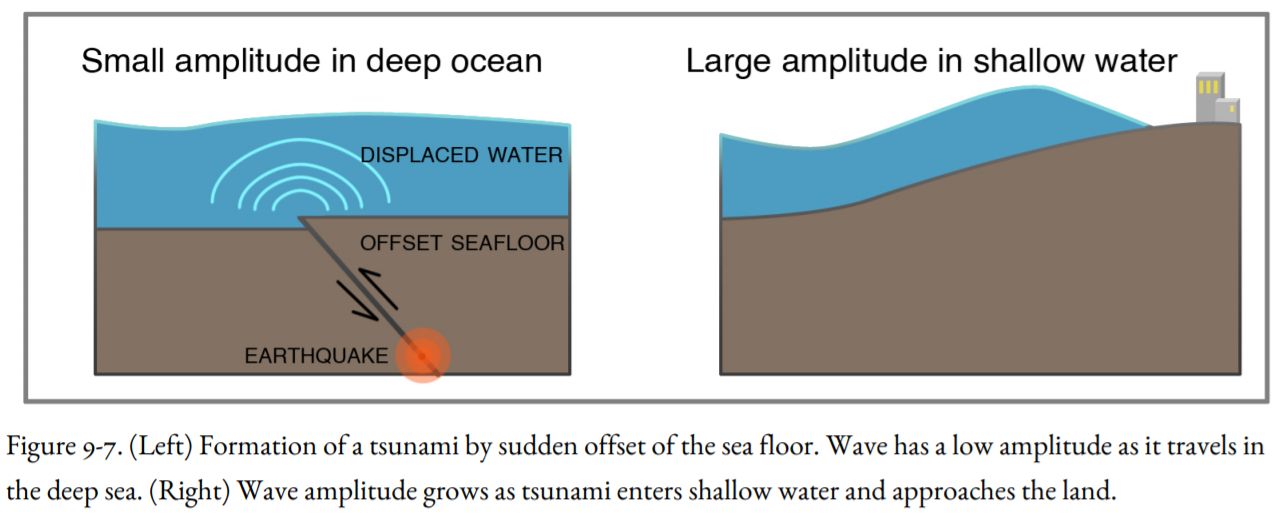
In the Alaska Earthquake of 1964, a section of seafloor more than four hundred miles long and one hundred miles across suddenly arched upward, forcing the overlying water upward and outward as if the seafloor were a giant paddle (Figures 4-14 and 9-7). Although this happened almost instantaneously, it was not the speed of the uplifted seas but the sheer volume of water displaced that produced the powerful tsunami. A tsunami generated by a sudden change in the deep ocean floor is a wave that extends from the bottom to the sea surface. The wave travels at great speed, five hundred miles an hour or faster, depending on the depth of the ocean.
The wave travels fastest through the deep ocean and slows down as it approaches the land, as can be observed in the computer simulation in Figure 9-1. The waves traveling down the coast are slower than those in the open sea so that the wavefront of the 1964 tsunami made a sweeping turn to the left and attacked the coast almost head-on.
Tectonic tsunamis have very long wave periods. (Figure 3-12 illustrates wave amplitude and wavelength; the period is the length of time it takes a full wavelength to pass a point.) An ordinary ocean wave breaking on the beach has a period of five to fifteen seconds, but a tsunami generated by a subduction-zone earthquake has wave periods ranging from seven minutes to nearly an hour, depending on the origin of the tsunami. It was the long periods of twenty-five to forty minutes that caused so much havoc at Crescent City and elsewhere. The wave rushed onshore and then it receded. When this happens, observers assume that the tsunami differs from an ordinary ocean wave in size only. If the next wave does not arrive in the next few minutes, they assume that the danger is past. They return to the shore, out of curiosity or a desire to help in rescue or cleanup operations. Then, perhaps as much as an hour later, another giant wave strikes. The loss of life from the follow-up wave, which might be bigger than the first one, is commonly larger than that from the initial wave.
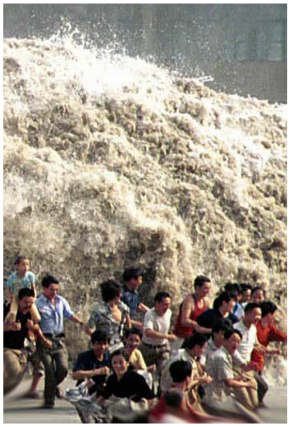
Figures 9-9 and 9-10 graphically (and disturbingly) illustrate the folly of rushing to the ocean too soon. In Figure 9-9, tourist swimmers have ventured away from shore as the next wave approaches. The sea bottom in the foreground is exposed because the incoming wave was immediately preceded by a drop in water level from the previous wave, giving the swimmers a false sense of security. The swimmers in the center of the photo realize that the next wave is approaching them, but it is too late for them. They were all drowned in the tsunami. In Figure 9-10, tourists have rushed to the shore to photograph the incoming tsunami, but the wave was much higher than they expected, and they also lost their lives.
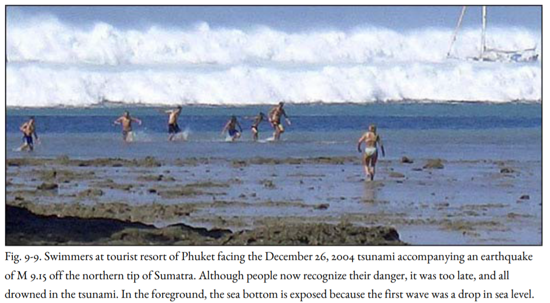
These two photos are a warning. If you hear a tsunami warning, DON’T GO TO THE BEACH; go to high ground immediately and stay there until you are told it is safe to return. It is my prayer that these two photos will save lives.
A tsunami has almost no expression on the ocean surface. (Here Figure 9-1 is misleading because it gives the impression that great wave heights are found in the deep ocean as well as along coastlines.) The height of a tsunami on the open ocean is typically only a few feet—less than the normal surface waves, and the wave height is gradual, not like a breaking wind-generated wave. Ships at sea cannot give a warning because people on board cannot detect the passage of the tsunami beneath the ship. During a deadly tsunami that struck Hilo, Hawaii in 1946, the crew of a freighter anchored offshore was surprised to see huge waves breaking over buildings and trees onshore because they were not strongly affected by the wave passing under their ship.
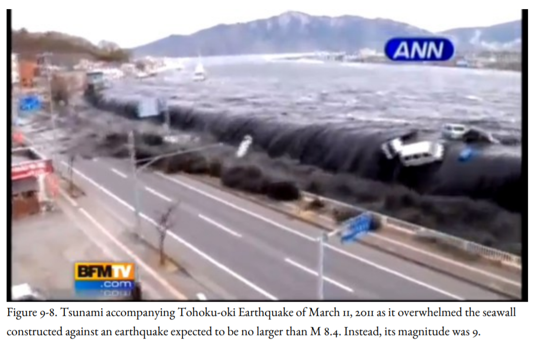
As a tsunami enters shallow water, it slows down but does not lose energy. It converts to a gigantic surface wave (Figures 9-7, 9-8, and 9-9). The way in which the tsunami approaches the shore is of critical importance in tsunami hazard analysis. It depends on the direction and energy of the approaching tsunami, of course, but it is also influenced by the configuration of the seafloor. Hilo Harbor in Hawaii is particularly susceptible to tsunamis because the adjacent seafloor is shaped like a funnel, concentrating the energy of the wave into a smaller area. In a similar fashion, the Vancouver Island fjords concentrated the wave energy of the 1964 tsunami like the nozzle of a fire hose, smashing against the communities at the heads of the fjords. Crescent City has a similar problem. Because the tsunami is controlled by water depth, even in deep water, the configuration of offshore banks and submarine canyons influences the size of a tsunami. Topographic maps of the seafloor, called bathymetric maps, are available for the west coast of the United States from the National Oceanic and Atmospheric Administration (NOAA). These bathymetric maps are important in determining which sections of the coastline are most susceptible to tsunamis.

In the 1964 earthquake, the seafloor was suddenly pushed upward and outward to the southeast, so that the first evidence of the tsunami in the Pacific Northwest was the great wave that crashed on the beaches and entered the harbors. But at Seward, Alaska, on the north side of the uplift, the force of the earthquake propagated away from the town. People at Seward saw a huge wave approaching them but as they looked at the remains of the small-boat harbor, they observed that it had been magically drained of water. This was part of the tsunami, too, but the sea had rushed away from land rather than toward it, immediately followed by the first wave to drive into the port and town.
Seward, and Cook Inlet behind it to the northwest, abruptly subsided during the earthquake, just as the coastal marshes of central Oregon, Washington, and Vancouver Island had subsided during the great Cascadia Earthquake of A.D. 1700, and previous earthquakes as well. If the next Cascadia earthquake behaves like the illustration in Figure 4-14, then the first evidence of the accompanying tsunami in northern Oregon or Washington might be a sudden outrushing of water, followed by a great wave. Coastal areas would see exposed parts of the seafloor that people living there had never before seen exposed (Figure 9-9), even at the lowest tides. There would be a great temptation to go to the beach to see this phenomenon—which could be fatal because there would not be enough time to get back to high ground before the first wave struck (Figures 9-9, 9-10).
Computer modeling of a Cascadia Subduction Zone tsunami predicts a different outcome for northern California because the coastline is much closer to the subduction zone than it is farther north (Figures 4-12, 4-22). The northern California coast would be suddenly uplifted, whereas the coast farther north would suddenly subside (Figure 4-14).
For those people who are into extreme sports, be advised that tsunamis are NOT surfable. The wave does not curl. It generally comes ashore as a rapidly rising surge of turbulent water choked with debris, including large logs. Even if a surfer managed to avoid being bashed to death by the maelstrom of debris, he or she could never “catch” the wave.