
5.2.4: A Brief Thirty-Million-Year History of Western North America
- Page ID
- 5914

Using sophisticated computer models, it is fairly straightforward to work out the plate-tectonic history of the Earth for hundreds of millions of years. This is illustrated in five stages in Figure 2-7, based on a copyrighted video created by Prof. Tanya Atwater of the University of California Santa Barbara through its Educational Multimedia Visualization Center and shown here as Figure 2-8. For an explanation in greater depth, see Atwater (1989).
What did the Pacific Northwest look like thirty million years ago?
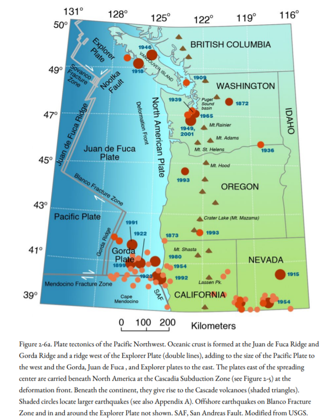
At that time, the oceanic crust west of North America formed part of the Farallon Plate, not the Pacific Plate (Figure 2-7, 2-8), and the Farallon Plate was being subducted beneath North America. The Farallon Plate and Pacific Plate were separated by the East Pacific Rise, part of the world-encircling mountain system that marks where new oceanic crust is formed (Figure 2-3) and spreads away, and by the Mendocino Transform Fault, which at that time was west of what would later become Los Angeles (Figures 2-7, 2-8). The Baja California peninsula was part of the Mexican mainland, with no Gulf of California in between.
Sea-floor spreading on the Mid-Atlantic Ridge had been forcing North America westward, away from Europe and toward the East Pacific Rise (Figure 2-3b). The Farallon Plate was being slowly subducted beneath North America, and active volcanoes erupted through the Cascades, the California Coast Range, and Baja California. The lofty cones of these old volcanoes were eroded away, and only the roots of the volcanoes are preserved in the deeply eroded mountains. As the Farallon Plate continued to be slowly consumed, the Pacific Plate came into contact with the North America Plate. But the Farallon Plate had been moving eastward, toward the continent, whereas the Pacific Plate was moving northwest, parallel to the continental edge. So, after the plates came into contact, the Pacific Plate moved northwest past North America along a new transform fault at the base of the continental slope, a forerunner to the San Andreas Fault (Figure 2-7, 20 My and 10 My). The Mendocino Triple Junction moved northwest, too, and the San Andreas ancestor grew in length as the former Farallon Plate broke up into the Juan de Fuca Plate off northern California, Oregon, Washington, and Vancouver Island, and the Cocos Plate off Mexico and Central America. Lavas continued to be spewed out in the Pacific Northwest and in Mexico even as they stopped along the transform fault in California.
About 4.5 million years ago, the transform fault shifted inland to its present position within the continent as the San Andreas Fault, and Baja California broke away from the rest of Mexico, leaving the Gulf of California in its wake. The Gulf of California is an ocean basin in the making, like the Atlantic Ocean one hundred and eighty million years ago, when the Americas were close to Europe and Africa. Baja California began to drift off to the northwest, taking coastal Alta California along with it and leaving a new ocean floor in its wake. The deep parts of the Gulf are mini-ocean basins called spreading centers. Basalt lava and hot springs are found in them, just as they are in the Mid-Atlantic Ridge and the East Pacific Rise. The northernmost spreading center, oddly enough, is in the Imperial Valley, where continental crust is being pulled apart at the same time that, and the gap is being filled by sediments of the Colorado River.
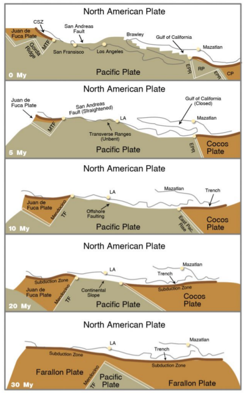
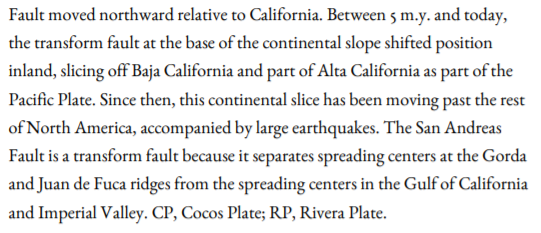
The Juan de Fuca Plate is breaking off the Gorda Plate along the Blanco Transform Fault (Figure 2-4b, 2-7), and the Rivera Plate (RP in the top map of Figure 2-7), part of the former Cocos Plate, has appeared at the mouth of the Gulf of California. Subduction still continues today in the Pacific Northwest and in Mexico south of the Gulf, accompanied by active volcanoes
Visualization of these examples of plate tectonics stretches the imagination until we recall that this has taken thirty million years, a length of time that overwhelms our ability to understand it. We are forced to put our imagination of natural processes into ultra-high-speed so that lifetimes flash by in a couple of seconds, and there is a plate-boundary subduction-zone earthquake at Cascadia every fifteen seconds. Even at that rate, the disappearance of the Farallon Plate would seem extraordinarily slow. If you were watching it as you would a movie, bring lots of popcorn.
Suggestions for Further Reading
Atwater, Tanya, 1989, Plate tectonic history of the northeast Pacific and western North America, in Winterer, E., Hussong, D., and Decker, R., eds., The Eastern Pacific Ocean and Hawaii: Geological Society of America Decade of North American Geology v. N, p. 21-72.
Glen, W., 1982. The Road to Jaramillo. Stanford, CA: Stanford University Press. An account of the plate tectonics revolution.
Kearey, P., and F. J. Vine. 1990. Global Tectonics. London: Blackwell Scientific Publications, 302 p.
Kious, W. J., and R. I. Tilling. 1996. This Dynamic Earth: the Story of Plate Tectonics: U.S. Geological Survey. Out of print, but on the web at http://pubs.usgs.gov/publications /text/dynamic.html
Lillie, R. J. 1999. Whole-Earth Geophysics. Englewood Cliffs, N.J.: Prentice-Hall, 361 p.