
7.5.2: California
- Page ID
- 6450

Overview
In 1853, five years after the start of the Gold Rush, a state geological survey was organized, with a prominent physician and geologist, John B. Trask, as the first state geologist. Three years later, Trask, also a co-founder of the California Academy of Natural Sciences, began publishing compilations of earthquakes that had struck California. This was not to alert people to the hazard, but to show “that California quakes were no more severe or frequent than those felt on the East Coast.” Trask’s geological survey expired but was followed in 1860 by a second state geological survey headed by Josiah D. Whitney. Whitney visited the area most heavily damaged in the 1872 Owens Valley Earthquake—the first time an earthquake had been studied by a scientist employed by the state. But Whitney’s style was abrasive, and he was more interested in studying fossils whereas the legislature wanted him to work on gold deposits. No one saw any value in studying earthquakes, so Whitney and his state geological survey were put out of business in 1874.
There was still interest in mining, though, and a state mining bureau was established in 1880, headed by a state mineralogist. This arrangement stayed in place until 1929, when the organization was renamed the Division of Mines and placed under the new Department of Natural Resources, under the supervision of the Mining Board. In that same year, the division hired its first geologist, whose assignment was to make a new geological map of the state. In 1961, the Division of Mines was renamed Division of Mines and Geology and placed under the Department of Conservation. Its head was named the state geologist, the first with that title since Whitney.
But the legislative charge to the division, like the USGS at the federal level, continued to be on mineral resources, although its geological staff had the expertise to work on environmental problems such as landslides and earthquakes. Things began to change in 1948 when Gordon B. Oakeshott was hired. Oakeshott and his family had been badly shaken by the Long Beach Earthquake of 1933, while he was completing his Ph.D. studies on the San Fernando Valley and western San Gabriel Mountains. Oakeshott was captivated by earthquakes, and he carried this fascination to his new job with the state.
Oakeshott’s chance came with the Kern County Earthquake of July 21, 1952, which he visited. At a meeting at Caltech, the Division of Mines agreed to publish a report to be edited by Oakeshott containing all the major scientific contributions from universities and government agencies alike. After the publication of this report in 1955, Oakeshott took the lead in earthquake studies within the division, even though there was no clear authority from the legislature or the Mining Board for the division to do so.
In 1959, Ian Campbell, a widely respected professor of geology at Caltech, became the new chief of the division. By focusing on mining, the division had mainly served the rural counties of the state, but Campbell believed that it should serve the cities as well. Urban sprawl was eliminating valuable deposits of sand and gravel, and Campbell justified an urban geology program to the Mining Board by calling it an assessment of sand and gravel resources around major cities. In 1960, he started a mapping program in an area near Los Angeles where landslides had been destroying expensive homes. Following the 1964 Alaska Earthquake, Campbell received approval from the board to start an urban hazards mapping program, including earthquake shaking, and to begin studies of the San Andreas Fault.
The Mining Board was reconstituted as the State Mining and Geology Board, and new appointees included earthquake geologist Clarence Allen, engineering geologist Richard Jahns, and earthquake engineer Karl Steinbrugge—all supporters of earthquake research. The division has now returned to its nineteenth-century name, the California Geological Survey.
A broad-based earthquake program was started with a budget of $260,000 in 1969 (one-fifth of the division’s total budget), increasing to more than $400,000 the following year. The popular division publication, Mineral Information Service (renamed California Geology in 1971), began to publish articles on earthquakes that were easy for the general public to read. (This publication was discontinued in 2002 as a result of a budget crisis.) At the request of the California Disaster Office (later the Governor’s Office of Emergency Services), the division published a map showing where earthquake damage could be expected. In 1970, an agreement was reached with the Division of Real Estate to review all proposals for subdividing land, about fourteen hundred per year. The Division of Mines and Geology recommended that, where appropriate, the Division of Real Estate should include a notice of possible earthquake hazard or other geologic hazards in its report to the public.
In 1969, following an earthquake-prediction scare in the Bay Area, State Senator Alfred Alquist of San Jose persuaded the legislature to appoint a Joint Committee on Seismic Safety, with himself as chairman. This legislative committee would be a driving force for earthquake legislation in the following decade. On February 9, 1971, the Sylmar Earthquake struck the San Fernando Valley, which Oakeshott had mapped as a Ph.D. student. This earthquake produced unusually high accelerations, leading structural engineers to request more information on the strong motion of earthquakes. In addition, a previously unrecognized reverse fault cut across housing developments, roads, and freeways, causing great damage. It became clear that the Field and Riley acts, which had been passed after the 1933 Long Beach Earthquake, were not adequate to regulate building construction. In addition, there was no requirement that active faults be taken into consideration in approving housing developments for construction.
Alquist’s Joint Committee on Seismic Safety heard recommendations resulting from the 1971 earthquake, including one that the state establish a program to measure strong ground shaking during earthquakes. This program was assigned to the Division of Mines and Geology and paid for by an assessment of 0.0007 percent of the value of new construction as part of the cost of the building permit—all except for Los Angeles and San Francisco, which already had such an assessment. The bill creating the Strong Motion Instrumentation Program was signed into law by Governor Ronald Reagan in October 1971. In the first three years of this program, the Division received nearly $1.25 million, an increase in its budget of about 25 percent.
Another law passed in 1971 was the requirement that cities and counties include a seismic safety element as one of the components of their general plan, adding earthquakes to other natural and urban hazards. This was an outgrowth of a requirement put into place in 1937 and beefed up in 1955 that each city and county adopt a general plan to guide decisions regarding long-term development. The Division of Mines and Geology, along with other agencies, helped develop guidelines for preparing seismic safety elements and assisted several counties in preparing their plans, including emergency response plans, a plan for reducing hazards from old, unsafe buildings; and a map of local seismic hazards. However, most local agencies did not develop procedures for building permit review, which is necessary to implement the hazard-reduction policies of their general plans.
What about active faults, like the fault that had ruptured in the 1971 earthquake and damaged or destroyed buildings on top of it? Developers in the San Francisco Bay Area were building directly across faults that were known to be active. Geologist Clarence Allen of Caltech argued that the most likely place for a future fault rupture is where the fault has ruptured in the past. Evidence for past rupture could be determined by geological investigations.
Two months after the Sylmar Earthquake, Sen. Alquist, through the Joint Committee on Seismic Safety, introduced a bill to require the state geologist to identify zones centered on the San Andreas Fault and other well-defined active faults, calling for special measures before construction on these zones could take place. Assemblyman Paul Priolo of Los Angeles introduced a similar bill, but both bills died in committee. The next year, both Alquist and Priolo revised their bills with advice from the Joint Committee on Seismic Safety and the Division of Mines and Geology. A compromise was necessary to get the support of local government lobbying groups, including adding an urban planner and a representative of county government to the State Mining and Geology Board. The final bill, renamed the Alquist-Priolo Geologic Hazard Zone Act, was signed into law by Governor Reagan in late 1972.
In the following year, guidelines for cities and counties were drawn up by the Mining and Geology Board defining an active fault under the new law. An Alquist-Priolo fault must have evidence of movement in the past eleven thousand years, the age of the Holocene Epoch following the Ice Ages. A geologic report on the presence of active faults was required prior to development in an Alquist-Priolo zone. The law established setbacks from the fault that would be off-limits for construction. The setback could be widened or narrowed based on the recommendation of the geologist; a wider zone might be mandated based on a broader fault zone or on uncertainty in locating the fault. Another provision of the law was that a seller was required to inform a potential buyer that the property for sale lies in an Alquist-Priolo zone.
When the first fault maps appeared in late 1973, they were criticized because they “amount[ed] to the libel of title to the lands inclosed” and “deprive[d] landowners of their property rights without due process of law.” In response to this opposition, single-family homes not part of a subdivision (four or more lots) and buildings with up to three living units were excluded from the law, and the law was renamed the “Alquist-Priolo Special Studies Zone Act,” a less-threatening title than “Geologic Hazard Zone.” An Alquist-Priolo fault was required to be well-defined by the Division of Mines and Geology. This neutralized enough of the opposition that fault zoning could continue.
The Alquist-Priolo Act has been amended eleven times and is now known as the Alquist-Priolo Earthquake Fault Zoning Act. The California Geological Survey (CGS) has issued 551 maps at a scale of 1 inch to 2,000 feet. On the basis of new evidence, 160 maps have been revised, and four have been withdrawn. Zone boundaries are set at five hundred feet away from most mapped faults but are as narrow as two hundred feet for less significant faults. For each fault that has been reviewed under the act, the CGS prepares a fault evaluation report documenting the reasons for zoning. CGS has completed 248 fault evaluation reports, which are available for public inspection. The geologic reports on proposed subdivisions required by the act must be accepted by the local jurisdiction, after which they are filed with the CGS where they, too, are available for public inspection. The fault-rupture hazard zones are described in detail by Hart and Bryant (1997), who also analyze the act’s success. See also the CGS website, www.consrv.ca.gov/ CGS/rghm/ap/ap_fer_cd/index.htm.
What is the track record of Alquist-Priolo? The only major surface ruptures since the act went into effect accompanied the 1992 Landers Earthquake and 1999 Hector Mine Earthquake, both in thinly populated or unpopulated areas in the Mojave Desert. Some of the faults that ruptured had been zoned under Alquist-Priolo, and others had not. The act has not really been tested by a major earthquake with surface rupture in an urban area along an Alquist-Priolo Zone fault.
Alquist-Priolo has been criticized as attacking the wrong problem: in the 1971 earthquake, the damage from surface rupture was considerably less than damage from other causes, such as strong shaking or liquefaction. The next three urban earthquakes, 1987 Whittier Narrows, 1989 Loma Prieta, and 1994 Northridge, were not accompanied by surface rupture at all, yet damage from the last two earthquakes ran into the billions of dollars. But the Chi-Chi, Taiwan, Earthquake of September 21, 1999, on a reverse fault was accompanied by many miles of surface rupture in developed areas, and the damage was nearly total along the fault rupture, with great loss of life, particularly in its hanging wall close to the fault (Fig. 12-15). The surface rupture was on a mapped fault. If Alquist-Priolo had been in effect in Taiwan when these areas were developed, great losses would have been prevented and many lives saved.
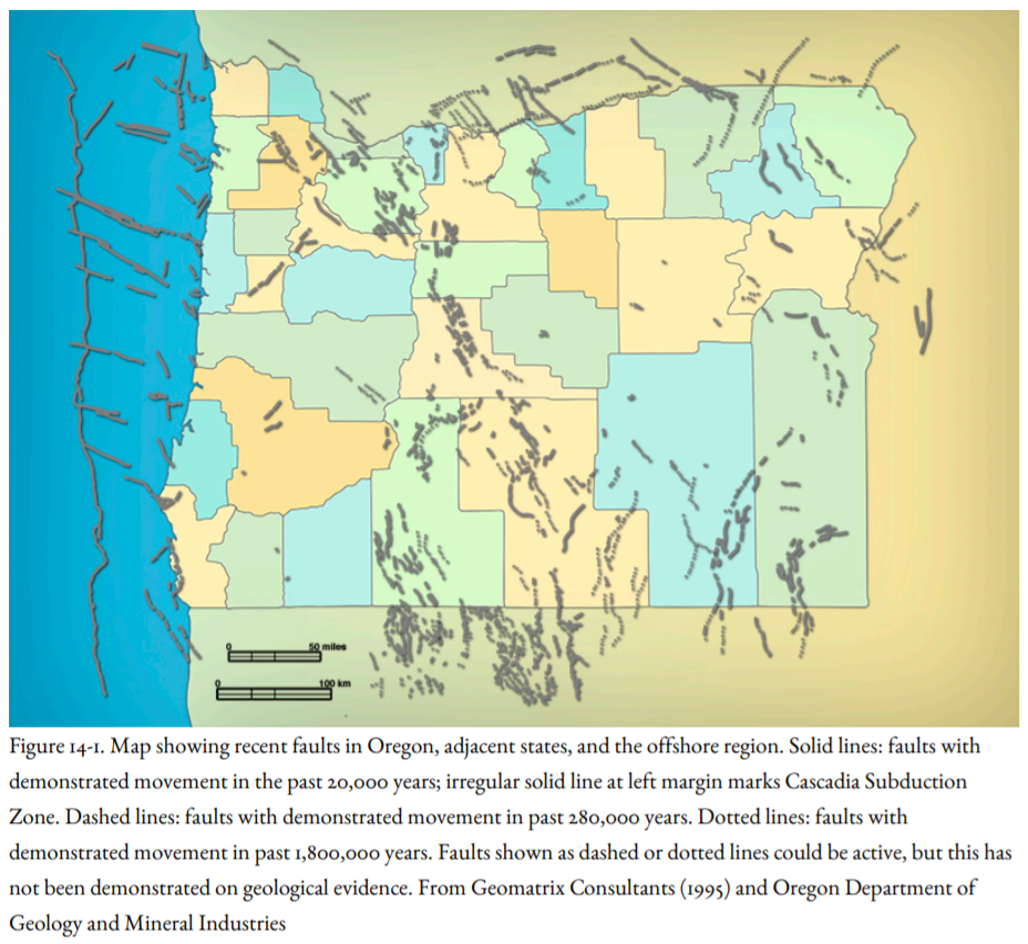
Should the Alquist-Priolo Act be exported to the Pacific Northwest? Many active faults have been mapped in Oregon (Figure 14-1) and Washington. In western Oregon, where most of the people live, only the Portland Hills Fault would be considered for Alquist-Priolo zoning; it is well defined, and it is marked by a linear scarp at the base of the Portland Hills, but without clear evidence of Holocene displacement. LiDAR imagery has revealed surface ruptures in the Puget Sound region that would qualify for Alquist-Priolo zoning, but the Seattle Fault would not qualify because it is not well defined at the surface. Blind faults do not qualify for Alquist-Priolo zoning, even in California. And in southwestern British Columbia, no faults have been mapped that would be zoned under AlquistPriolo.
The 1994 Northridge and 1989 Loma Prieta earthquakes in California demonstrated that much of the damage was to buildings in areas that underwent liquefaction and landslides. As noted in Chapter 8, geological and geotechnical studies are able to identify building sites that are vulnerable to earthquake-related ground displacements. To address this hazard, the Seismic Hazard Mapping Act was signed into law in 1990, which requires that not only active faults but earthquake-induced liquefaction and landslides must be taken into consideration in planning and development decisions.
Maps have been prepared for much of the Los Angeles metropolitan area and for the cities of San Francisco and Oakland, with additional maps being prepared (see the California Geological Survey Web site at http://www.consrv.ca.gov/). The mapping program is supported by building permit fees supplemented by a grant from FEMA and the Office of Emergency Services. Cities and counties must use these maps to regulate development within areas identified as seismic hazards. Building permits must be withheld until the developer shows that the development plan will mitigate the hazard. The law is not retroactive, but if the property within a seismic hazard zone is sold, the seller must disclose that fact to the buyer.
However, the lack of any major urban earthquakes since the 1994 Northridge earthquake has led to a reduction of enforcement standards in the Los Angeles metropolitan area, although starting in 2014, the Mayor of Los Angeles, advised by Lucile Jones of USGS, is committed to stronger enforcement.
Similar maps have been prepared for urban areas in Oregon, Washington, and British Columbia, but their use is advisory only, not mandated by law.
Does this cover all hazards? What about faults or folds that are clearly active but are not well defined according to the Alquist-Priolo Act? For example, geotechnical investigations connected with the planned Los Angeles subway revealed a warp on the south side of the Repetto Hills and Elysian Hills in East Los Angeles called the Coyote Pass Escarpment. This is not a well-defined fault, but it would clearly result in damage if it deformed during an earthquake. This hazard is covered under the Seismic Hazard Mapping Act. Response to faults that are not well defined departs from the Alquist-Priolo strategy of mitigation by avoidance (don’t build on an earthquake fault) to mitigation by design (recognize the zone of deformation, then design structures that will survive surface deformation on it), which is the intent of the Seismic Hazard Mapping Act.
The actions taken by the state of California starting in the early 1970s were groundbreaking, even revolutionary. In no state in the United States and in no country in the world, including Japan, has the government taken such steps to mitigate earthquake hazards. Earthquake programs in all other states lagged behind the establishment of a national earthquake program and, for the most part, they have been financed by federal grants. California, on the other hand, preceded the establishment of a national program by more than four years!
The Governor’s Office of Emergency Services (OES) is the state’s counterpart to FEMA, and federal disaster assistance is transmitted through OES. Like FEMA, the agency started out in civil defense in 1950, when the Soviets were ramping up their nuclear weapons program, and Chinese troops were battling Americans in Korea. By 1956, the agency became more involved in natural disaster operations, and the name was changed from the State Office of Civil Defense to the California Disaster Office. The Emergency Services Act was passed in 1970, and the agency’s name was changed to the Governor’s Office of Emergency Services (OES). In 2008, the cabinet-level California Emergency Management Agency and the Office of Homeland Security were combined as part of OES.
The OES coordinates the response of state agencies to major disasters in support of the local government. These disasters might be major wildfires, winter storms, floods, tsunamis, or earthquakes. They might be dam breaks, nuclear power plant emergencies, major spills of hazardous materials, and now, terrorist attacks. Communications vans and portable satellite units are available to be sent to disaster areas to ensure communications with remote areas as well as major cities where communications have been knocked out by an earthquake. One hundred and twenty fire engines are available at fire stations in strategic locations. A warning center is staffed twenty-four hours a day, and daily contact is maintained with the National Warning Center and offices of emergency services located in every county.
OES is responsible for the State Emergency Plan, California’s equivalent to the Federal Response Plan. This plan contains the organizational structure of state response to natural and man-made disasters. OES helps local governments and other state agencies in preparing their own emergency preparedness and response plans. A list of publications and videos is provided on the OES Web site at http://www.oes.ca.gov/ The Earthquake Program of OES provides assistance to local and regional governments, businesses, hospitals, schools, human service agencies, community organizations, and individuals in earthquake preparedness. This program has coordinated, through the California Geological Survey, earthquake scenarios on the Cascadia Subduction Zone, the San Jacinto Fault in southeast California, and the Rodgers Creek Fault in the Bay Area, and the Great California ShakeOut response each October 15 to an M 7.8 earthquake on the southern San Andreas fault. The state’s Earthquake Awareness Month is in April, the month in which the 1906 San Francisco Earthquake struck.
The Seismic Safety Commission was established by the legislature in 1975 as a state agency to advise the governor, the legislature, and the public on ways to reduce earthquake risk. The commission manages the California Earthquake Hazard Reduction Program and reviews earthquake-related activities funded by the state. Fifteen of the seventeen commissioners are appointed by the governor, and the other two by the senate and assembly. In 1985, the California Earthquake Hazards Reduction Act charged the commission with preparing an Earthquake Loss Reduction Plan, most recently for 2007-2012, to reduce earthquake hazards significantly. The commission proposes earthquake bills to the legislature and will oppose legislation that would weaken the state’s earthquake safety program.
The commission issues reports on earthquake hazard reduction, including reports on building codes. Lists of publications are available at the commission’s web site at http://www.seismic.ca.gov One of these publications is The Homeowner’s Guide to Earthquake Safety. If your house was built before 1960, and you want to sell it, state law requires you to deliver a copy of the Homeowner’s Guide to the buyer.
Humboldt and Del Norte counties are at risk from the Cascadia Subduction Zone, and activities in California have led to greater resilience to the Cascadia Subduction Zone in California than in regions to the north.