
5.5.5: Discussion and Summary
- Page ID
- 5967

Overview
Why should seismicity within the subducting oceanic plate be concentrated in the Puget Sound region? Oddly, this lower-plate seismicity does not extend very far south into Oregon (Figure 5-1). If subduction is taking place all along Cascadia, why should seismicity be concentrated only in Washington?
To answer this question, we look at the contours of the subducting Juan de Fuca Plate and we observe that the plate has an eastward-convex bend in Washington, curving from a north trend in Oregon to a northwest trend in southwest British Columbia (Figure 5-8). This bend is also reflected in the distribution of Cascade volcanoes (Figure 5-1). In northern California, Oregon, and southern Washington, these volcanoes line up north-south, parallel to the subduction-zone contours. But in southwest British Columbia and northern Washington, including Mt. Baker and Glacier Peak, the volcanoes line up northwest-southeast, parallel to the subduction-zone contours.
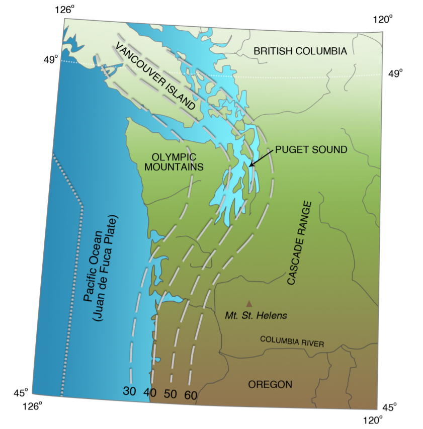
This arch in the subduction zone may explain why the Olympic Mountains are so much higher than the Coast Range of Oregon or the hills of southwest Washington. The Olympic Mountains are arched up where the subduction zone bends the most, in map view.
To imagine the effect of this eastward-convex arch, consider a tablecloth hanging over the corner of a table. The tablecloth is straight along the sides of the table, but it makes a fold at the corner. Now suppose that, instead of a tablecloth, the table is covered by a sheet of hard plastic, the edges of which stick out over the side of the table. You want to bend the plastic down the side of the table, like the tablecloth, but you find that it won’t bend at the corner unless you make a cut in the plastic so that the two sides fit together down the sides. (This is the same difficulty I have in gift-wrapping a present in a box. The wrapping folds neatly down the sides of the box, but in order to make the corners neat, I have to make a fold in the wrapping paper where it goes around the corner. I do not excel at this, and so I generally have the present gift-wrapped at the store or by my wife.)
The Juan de Fuca Plate has the same problem when it is forced to bend beneath North America. The plate can bend easily beneath Oregon or beneath southwest British Columbia, where the subduction zone is straight, but in trying to bend beneath the curved arch beneath Washington, internal stresses are built up that generate earthquakes.
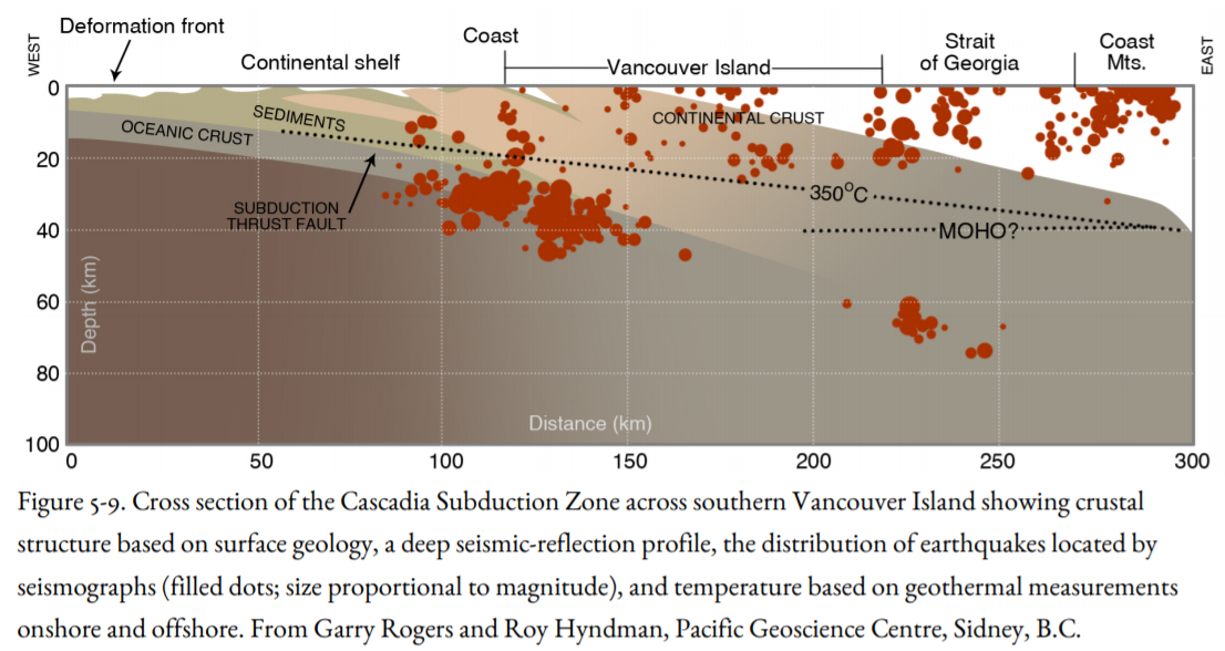
This “corner problem” explains the distribution of slab earthquakes beneath Puget Sound, but not in southwest British Columbia. Slab earthquakes occur there in two zones, even though the downgoing Juan de Fuca Plate there is relatively straight. One zone is a northward continuation of the Puget Sound deep zone, and it dies out near Vancouver (Figure 5-1). The other zone is beneath the west coast of Vancouver Island and it has lots of earthquakes (Figure 5-9). Leiph Preston and Ken Creager of the University of Washington have found earthquakes in this western zone as far south as southwestern Washington. These earthquakes tend to occur in the oceanic mantle of the Juan de Fuca Plate whereas earthquakes of the eastern zone are more likely in the oceanic Juan de Fuca crust (Figure 2-5).
Why should the slab have earthquakes beneath the straight subduction zone in British Columbia, but not the straight subduction zone in Oregon? Seismologists at the Pacific Geoscience Centre in Sidney, B.C., are quick to say that “we really don’t know.” The deeper zone of high seismicity may correspond to a downward increase in the dip of the subducting slab beneath Vancouver Island and the mainland coast, producing a bend in the slab (Figure 5-9). The zone beneath the west coast of Vancouver Island may correspond to a shallower bend, but seismologists disagree on this point.
We have assumed that Oregon has a hazard from slab earthquakes, just as Washington does, even though it has not had any big slab earthquakes in historical time, with the possible exception of the 1873 earthquake near the California border, considered further below. Perhaps the Puget Sound earthquakes are in a temporal cluster, an increase in slab earthquakes over nearly a century, and at some future time, Oregon might have a similar cluster. Not only does Oregon lack large slab earthquakes, but it also has essentially no small ones either, whereas these are abundant in western Washington and in northern California (Figure 5-1). It is difficult to explain the lack of slab seismicity by saying that the slab is fully locked because the earthquakes farther north are broadly distributed and are not localized on a few faults within the slab. Ivan Wong of URS Greiner Associates (2005) suggests that the Oregon slab is younger than it is in Washington, and the convergence rate between the Juan de Fuca and North America plates may be slower than in Washington. In addition, the crust of western Oregon is underlain by Siletzia basalt, which, as stated above, keeps the temperature of underlying Juan de Fuca Plate too hot to generate slab earthquakes. Wong also reanalyzed the 1873 Brookings earthquake, previously believed to have occurred in the Juan de Fuca Plate, and concluded that this earthquake was crustal, like similar earthquakes in northern California. The implication of Wong’s observations is that western Oregon faces hazards from the subduction zone and earthquakes in the crust, but unlike western Washington, does not face a hazard from the Juan de Fuca Plate. However, this idea is speculative, and not confirmed enough for Oregonians to relax and not worry about slab earthquakes like those in Washington.
Another mystery is that wherever the deep slab is seismically active, the overlying continental crust is active, too. The crustal seismicity is high beneath Puget Sound where the slab seismicity is high. In Northern California, both the Gorda Plate and the overlying and adjacent continental crust are characterized by frequent earthquakes. On Vancouver Island, the largest crustal earthquakes occurred on the onshore projection of the Nootka Transform Fault, and they were characterized by left-lateral strike-slip faulting, just as earthquakes on the Nootka Fault are.
If our speculations about a bending origin for the localization of seismicity are correct, there should be no relationship between earthquakes in the slab and earthquakes in the crust. Yet they appear to be somehow tied together, even though the seismicity zones in North American crust and in the Juan de Fuca Plate are generally separated by the lower crust that is too hot and ductile to produce earthquakes (Figure 5-9). These questions, now being addressed by seismologists in Canada and the United States, are of practical importance because they bear on estimates of hazards in the Pacific Northwest and the Vancouver-Victoria region.
In summary, the three largest slab earthquakes in the Puget Sound region were characterized by very large areas of intensity VII, but only the 1949 earthquake had a very large area of intensity VIII. There were no areas of higher intensity, such as one would expect for crustal earthquakes of the same magnitude, probably due to the greater distance from the source to the ground surface. Unlike crustal earthquakes, the Puget Sound slab earthquakes, including the 1939 and 1946 Puget Sound earthquakes, lacked significant aftershocks. A deep earthquake off the west coast of Vancouver Island on December 16, 1957, with M 5.9, had only one aftershock, and intensities recorded were not much higher than III. The Nisqually Earthquake had four aftershocks in the following two weeks.
Even though the slab earthquakes beneath western Washington have caused most of the damage and loss of life in the Pacific Northwest, the general conclusion is that the Juan de Fuca Plate beneath the edge of the North American continent is not capable of storing enough strain energy to produce earthquakes much larger than the M 7.1 event of April 1949 beneath Puget Sound. But the downgoing plate, covered as it is by continental crust, is still not well enough known to make this statement with a lot of confidence.
Suggestions for Further Reading
Preston, L. A., K. C. Creager, R. S. Crosson, T. M. Brocher, and A. M. Tréhu. 2003. Intraslab earthquakes: Dehydration of the Cascadia slab. Science, v. 302, p. 1197-1200.
Rogers, A.M., T. J. Walsh, W. J., Kockelman, and G. R. Priest, eds. 1996. Assessing earthquake hazards and reducing risk in the Pacific Northwest. U.S. Geological Survey Professional Paper 1560, 306 p.
Staff of the Pacific Northwest Seismograph Network. 2001. Preliminary report on the MW = 6.8 Nisqually, Washington earthquake of 28 February 2001. Seismological Research Letters, v. 72, p. 352-61.
Thorsen, G. W., compiler. 1986. The Puget Lowland earthquakes of 1949 and 1965.Washington Division of Geology and Earth Resources, Information Circular 81, 113 p.
Washington Division of Geology and Earth Resources Staff. 1999. July 2, 1999, Satsop earthquake. Washington Geology, v. 27, no. 2/3/4, p. 28-29. Includes an account by John Hughes of The Daily World, Aberdeen.
Washington Division of Geology and Earth Resources Staff. 2001. Nisqually earthquake issue. Washington Geology, v. 26, no. 3, p. 2-21.
Wong, I.G., 2005, Low potential for large intraslab earthquakes in the central Cascadia Subduction Zone: Seismological Society of America Bulletin, v. 95, p.1880-1902.