
5.2.3: The Dance of the Plates; We Know the Beat but Not the Tune
- Page ID
- 5913

Overview
The dominant cause of the tectonic activity that takes place at the Earth’s surface is the extremely slow flow of rock in the mantle that is solid, yet ductile. This leads us now to a discussion of plate tectonics.
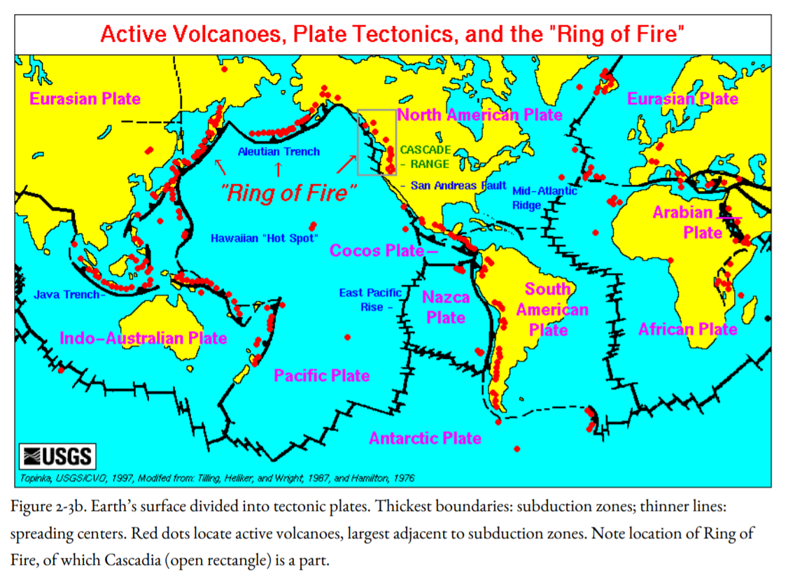
We would have no earthquake problem if the lithosphere, 60 miles thick, completely encircled the Earth without any breaks, as it does on the other inner planets. Unfortunately, though, the 60-mile thickness of the lithosphere on the “third rock from the sun” is not enough to withstand the stresses coming from the slow, roiling currents of the asthenosphere below. The lithosphere is broken up into gigantic tectonic plates (Figure 2-3a, 2-3b, 2-4) that grind against one another, producing earthquakes and volcanic eruptions in the process. Most of these plates are of continental size. The Pacific Northwest is part of the North American Plate, which extends all the way across the United States and Canada to the middle of the Atlantic Ocean (Fig. 2-3b). Most of the Pacific Ocean is underlain by the Pacific Plate, the world’s largest, which reaches to Alaska, Japan, and New Zealand (figure 2-3b). Other plates are smaller, like the Juan de Fuca Plate off the Pacific Northwest coast, which is a little smaller than Washington and Oregon taken together (Fig. 2-4b).
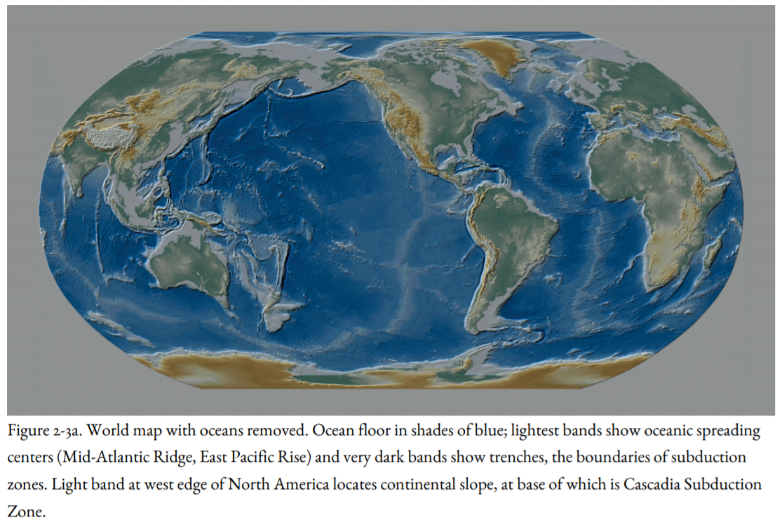
Running down the center of the floor of the Atlantic Ocean, like the seam on a baseball, the Mid-Atlantic Ridge (Figures 2-3a, b) is formed by the upwelling of hot material from the asthenosphere, which broke up the granite supercontinent of Pangea, starting about one hundred and eighty million years ago. North and South America, fragments of Pangea, sailed away from Africa and Eurasia like great granitic ice floes in a basaltic sea, and the deep Atlantic Ocean floor of basalt began to grow in the widening rift welling up between the continents. The Atlantic Ocean Basin is still widening at a rate slightly less than an inch per year. The Mid-Atlantic Ridge is a ridge (lighter blue, Figure 2-3a) because the newly formed oceanic lithosphere is hotter and thus lighter and more buoyant than older oceanic lithosphere closer to the continents. There are hot springs along the ridge, called black smokers (first discovered by marine scientists from OSU), and new basaltic lava flows erupt on the ocean floor at the ridge. All of the ocean floor of the Atlantic has been created as basaltic lava in the past one hundred and eighty million years.
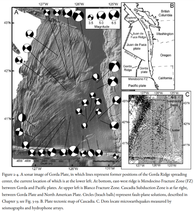
There is also a ridge in the Pacific Ocean called the East Pacific Rise, but this ridge is not at the center of the ocean, like the Mid-Atlantic Ridge. Instead, it lies toward the eastern margin of the Pacific (Figures 2-3a, b). But its origin is the same: oceanic crust rises to the surface and solidifies at the East Pacific Rise, then it moves away to the east and west. That part moving toward the west becomes part of the great Pacific Plate. That part moving toward the east becomes part of several smaller plates off the west coast of North and South America, including the Juan de Fuca Plate off the Pacific Northwest (Figure 2-4b, 2-6), and the Cocos Plate off Mexico and Central America (Figure 2-3b). These plates drive against and beneath the American continents.
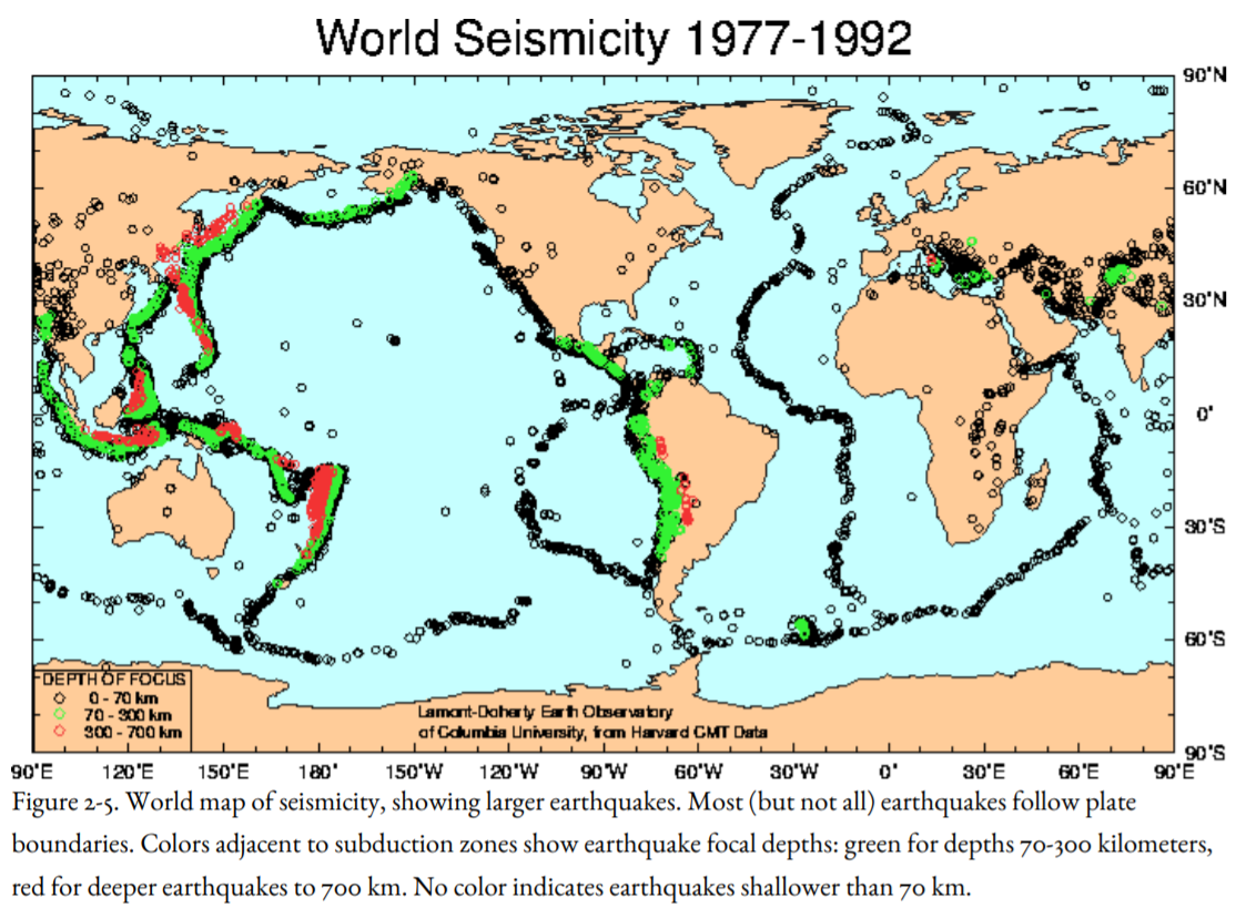
But if a new crust is being made, then old crust must be destroyed at the same rate somewhere else, because the Earth has remained the same size through time. The destruction of the crust takes place at the subduction zones, where the oceanic lithosphere sinks down into the asthenosphere. Most subduction zones are found around the edges of the Pacific Ocean, which leads to the name Pacific Ring of Fire (Figure 2-3b) because of the abundance of active volcanoes and earthquakes, including the largest earthquakes experienced on Earth. The greatest depths in the oceans, nearly seven miles, are found in deep-sea trenches in the western Pacific (Figure 2-4, 2-5), where oceanic lithosphere is being subducted beneath the Philippines and beneath the Marianas Islands and the island of Guam. Volcanoes erupt through the lithosphere of the plate on top.
One of these subduction zones, the Cascadia Subduction Zone, lies off the Pacific Northwest, including northern California, where the Juan de Fuca, Gorda, and Explorer plates are being driven beneath the North American continent (Figures 2-4, 2-5, 2-6). Mt. Baker, Mt. Rainier, Mt. St. Helens, Mt. Hood, Mt. Shasta, and Mt. Lassen are products of the subduction of the Juan de Fuca and Gorda plates. The Cascadia Subduction Zone is discussed further in Chapter 4.
At some plate boundaries, the lithosphere is neither created at a mid-ocean ridge nor destroyed at a subduction zone. Instead, two plates crunch and grind past each other, producing earthquakes in the process. These boundaries are called transform faults, and on the ocean floor, they are called fracture zones. The best-known transform fault on Earth is the San Andreas Fault of California (lower right corner of Figure 2-4b, Figure 2-6), where the Pacific and North American plates grate past each other. Off the Pacific Northwest, part of the boundary between the Juan de Fuca-Gorda and Pacific plates is the Blanco Fracture Zone, separating the Gorda and Juan de Fuca ridges (Figures 2-4c, 2-6, 2-7). Both the San Andreas Fault and the Blanco Fracture Zone are major sources of earthquakes.
Scientists are able to determine the rates at which the plates move with respect to one another. This is done by observing changes in the Earth’s magnetic field preserved in the oceanic crust (Figure 2-6) and by drilling core holes in the deep-ocean floor to determine the age of the oldest sediment overlying the basaltic crust in various parts of the oceans. In the last few years, these rates have been confirmed by direct measurements using space satellites through the Global Positioning System (GPS) and by the relative motion of radio telescopes with respect to quasar signals from outermost space (discussed further in Chapter 3). All our information about relative plate motion can be fed into a computer model that tells us the motion of any given plate with respect to any other. We can even predict with some confidence the plate configuration of the Earth millions of years from now, which allows us to forecast that coastal California, including Los Angeles, is moving slowly but inexorably toward Alaska (video, Fig. 2-8).
However, we have no underlying theory that explains why the plates move as they do, which leads to our description of the dance of the plates: we know the beat, but we don’t know the tune.
Near the tiny settlement of Petrolia in northern California, the Pacific, North America, and Gorda plates come together in a seismically active place called the Mendocino Triple Junction (Fig. 2-7). North of the triple junction, the Gorda Plate is driving beneath the North American continent (Figures 2-4 and 2-8). Southeast of the junction, North America is sliding southeast against the Pacific Plate along the San Andreas Transform Fault. West of the junction, the Pacific Plate is sliding westward against the Gorda Plate along an oceanic transform fault called the Mendocino Fracture Zone (Figures 2-4, 2-6, and 2-7). We know the rates at which these processes are taking place, and so we can reconstruct the plate tectonic history of western North America backward for the last thirty million years.