
6.2.5: Tsunami Warning Systems
- Page ID
- 6047

Overview
The tsunami at Crescent City struck more than four hours after the earthquake. Loss of communication with Alaska delayed the issuance of a tsunami advisory for nearly an hour and a half after the earthquake, and the advisory was not upgraded to a warning until two hours and twenty minutes after the earthquake—about the time the first wave was striking the north end of Vancouver Island.
The warning system in place at that time—the Pacific Tsunami Warning Center—was established in Hawaii after a disastrous tsunami in Hawaii in 1946 caused by an earthquake on the Aleutian Subduction Zone of Alaska. The Hawaii center was not designed to warn against tsunamis like the one produced by the 1964 Alaska Good Friday Earthquake, so a second warning center was set up—the West Coast/Alaska Tsunami Warning Center in Palmer, Alaska. Both are operated by NOAA. The Alaska center initially was organized to warn against tsunamis only in Alaska, but now it’s responsible for alerting Alaska, British Columbia, Washington, Oregon, and California about all earthquakes around the Pacific that might produce a tsunami.
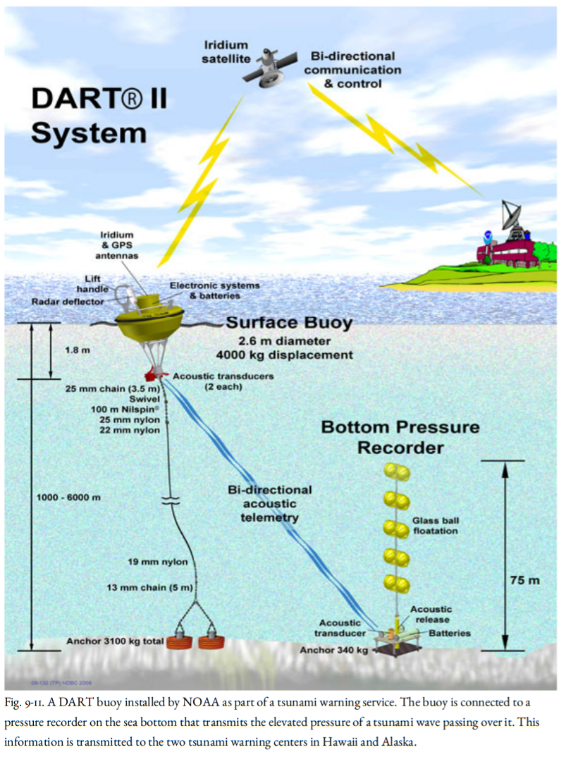
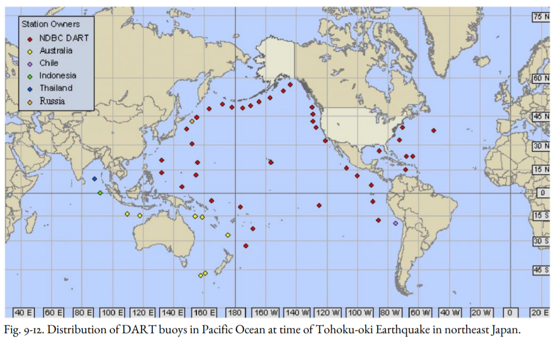
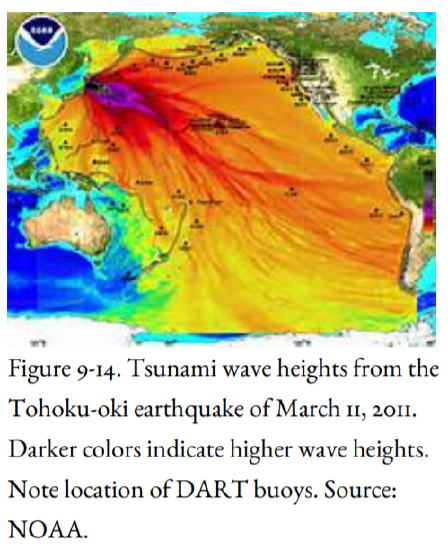
Seismographs and tide gauges around the Pacific Rim report immediately to Ewa Beach, Hawaii, and Palmer, Alaska, and tsunami arrival times are estimated for shorelines around the Pacific. The Deep-ocean Assessment and Reporting of Tsunamis (DART) Project has installed pressure gauges on the deep ocean floor, permitting tracking of tsunamis in the deep sea in real-time, which has never before been possible (Figure 9-11). NOAA has a large number of DART tsunami detectors in the Pacific Ocean and a few in the Atlantic and Indian oceans (Figure 9-12). There were enough DART buoys in place that the magnitude 9 Tohoku-oki earthquake was tracked by the buoys as it traveled from Japan across the Pacific Ocean. In addition, the seismic networks in southern Alaska, western Washington and Oregon, and northern California were upgraded.
When a subduction-zone earthquake of moment magnitude 7.5 or larger strikes anywhere around the Pacific Ocean (magnitude 7.0 or larger on the Aleutian Subduction Zone), the tsunami warning centers swing into action. After the epicenter of the earthquake has been located from the seismic network (commonly within a few minutes) and the earthquake is confirmed as shallow, rupturing the subduction zone, the travel time of a potential tsunami is estimated, and stations near the epicenter are alerted. A tsunami warning is issued to all communities within three hours of the first wave. For communities three to six hours away from the first wave, a tsunami watch is established. For coastal regions that are still farther away, an advisory bulletin is issued and is updated as more information becomes available, such as confirmation of a tsunami by observers, tide gauges, or deep-sea DART pressure gauges. For the West Coast, the tsunami warning would come from Palmer, Alaska. As the tsunami advances, its progress is monitored, and the warning is updated with new projected arrival times of waves and possible wave heights. This gives time for local authorities to order the evacuation of low-lying areas. If a tsunami warning is issued for Hawaii, evacuation of low-lying areas is mandatory, but in other states, the decision to evacuate is made by local authorities.
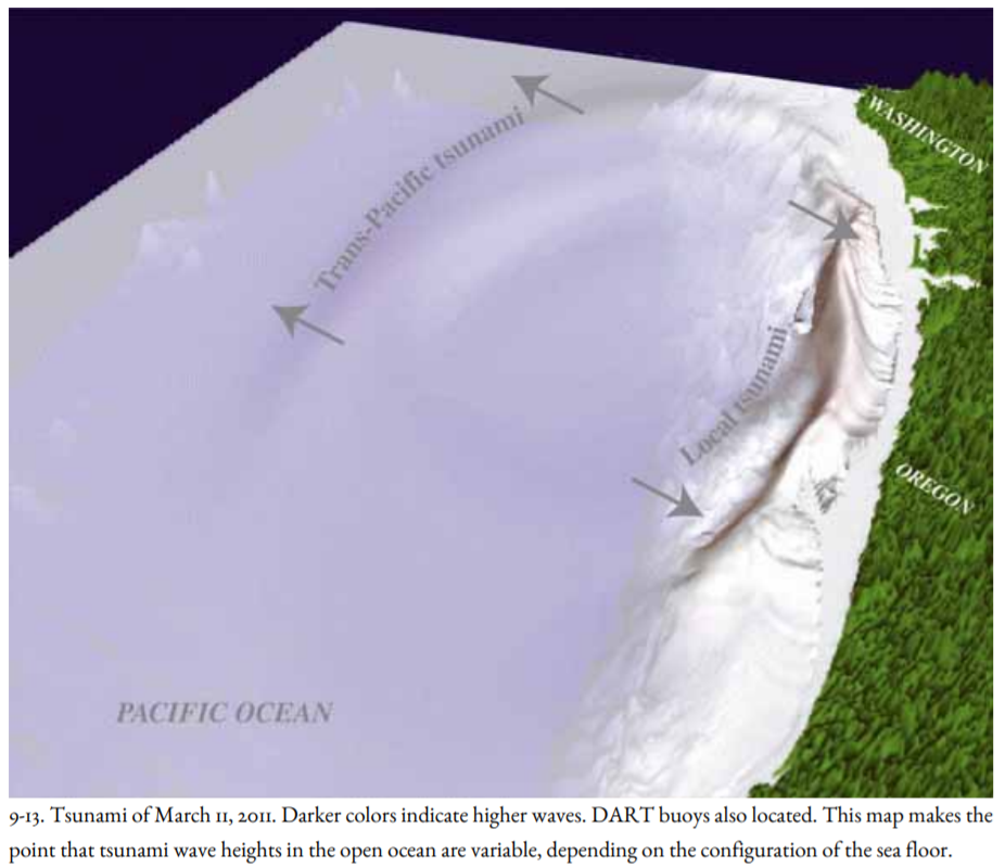
Computer modeling of tsunamis gives more confidence to the warnings, although modeling is not yet used by the tsunami warning centers in issuing warnings or alerts. This might change because models can take into account the strong directivity of tsunamis (Figures 9-13, 9-14). It’s important to learn not only the location of the epicenter and the magnitude of an earthquake but also the direction of motion of the ocean floor, which can be determined by studying the waveforms of seismograms of the mainshock recorded at many seismograph stations. Armed with such information, the warning of the 1964 Alaska tsunami could have been more strongly directed to the west coast of North America and less toward Japan, which recorded the tsunami but suffered no damage.
 A tsunami wave was once compared to the waves in a pond radiating out from a pebble that is thrown into it, with the pebble representing the earthquake. The directivity of a tsunami leads to a better analogy. It’s more like throwing a log into the water; waves in front of the log are much higher than the waves at the ends.
Tsunami warning systems worked well for two distant tsunamis that traveled great distances: the tsunamis of 1952 and 1957. But they were of limited value in saving lives from the 1960 Chile tsunami that traveled from Chile to Japan, and the 1964 Alaska tsunami that did damage as far away as southern California. Furthermore, more than 75 percent of the tsunami warnings have been false alarms. Nevertheless, a partnership among the USGS, NOAA, and the five western states called CREST (Consolidated Reporting of Earthquakes and Tsunamis) has reduced the response time from more than ten minutes to less than two minutes for the 2001 Nisqually Earthquake.
What about warnings to coastal areas when the earthquake occurs on a fault that is just offshore? Tsunami warnings were of no use to towns in southern Alaska struck by the 1964 tsunami. How about an earthquake on the Cascadia Subduction Zone or on the Seattle Fault in Puget Sound? There is little time—perhaps less than ten or fifteen minutes—before the first wave reaches the coast (Figure 9-13). A tsunami struck Okushiri Island off the northwest coast of Japan only two to three minutes after a large offshore earthquake, killing schoolchildren on the beach.
The best advice now for regions subjected to subduction-zone earthquakes is to get to high ground immediately when the shaking from a great earthquake stops long enough to allow one to move. Don’t wait for a tsunami warning. The Cascadia tsunami off the Oregon coast will arrive within 20 minutes of strong ground motion. Some earthquakes generate tsunamis that are unusually large for the amount of shaking they cause. This can happen for two reasons.
Some earthquakes are characterized by motion of the ground that is so slow that little shaking damage occurs, even though the earthquake magnitude is large. A slow earthquake in Nicaragua on September 2, 1992, produced a tsunami that killed hundreds of coastal villagers, even though the amount of shaking was deceptively small. If a slow earthquake struck a coastal area, people might not take seriously the tsunami potential of the earthquake seriously until it was too late.
The second reason is that an earthquake can trigger a submarine landslide. On July 17, 1998, more than twenty-two hundred villagers along a fifteen-mile stretch of the north coast of Papua New Guinea lost their lives in a tsunami that was generated by an earthquake of M 7.1. The earthquake apparently caused a submarine landslide, and the earthquake and landslide together produced a tsunami with wave heights of thirty to forty-five feet. The tsunami arrived about twenty minutes after the earthquake. In contrast to the long periods of tsunamis from a distant source, the Papua New Guinea tsunami had wave periods of one to five minutes. Landslide-generated tsunamis are of particular concern to the Pacific Northwest; huge landslides off the southern Oregon coast mapped by Chris Goldfinger probably generated large and devastating tsunamis.
In the 1964 Alaska Earthquake, Seward and Valdez were hit by tsunamis from two different sources. The first one was triggered by submarine landslides immediately offshore, extending onshore and causing the collapse of the waterfronts of both towns. In some areas, waves began to strike less than sixty seconds after the beginning of the earthquake, while strong shaking was still going on. The landslide-generated tsunamis caused the largest waves, more than one hundred sixty feet high at Valdez, with waves bouncing off the sides of the narrow bays leading into the towns for ten to fifteen minutes. Then, about fifteen minutes after the beginning of the earthquake, the tectonic tsunami arrived, generated by the sudden change in depth of the seafloor in Prince William Sound. The tsunamis were worse because both towns are at the heads of narrow fjords. This concept is illustrated for Cascadia in Figure 9-13. One set of tsunamis heads toward the Northwest coast, taking about 15 to 20 minutes after the earthquake to arrive. The other set heads west into the Pacific Ocean, arriving in Japan and other areas several hours later, allowing a warning to be issued for Japan.
The 1992 Cape Mendocino Earthquake generated a small tsunami that arrived at Eureka twenty minutes after the earthquake and at Crescent City forty-seven minutes after the quake. Waves continued to arrive for about ten hours, with the strongest waves eighteen inches high at Crescent City almost four hours after the earthquake.
As was shown in the 1964 tsunami, a warning system needs more than notification by radio. A siren system would wake people up if the tsunami struck at night, as it did in 1964. The siren at Copalis Beach, Washington, probably saved lives in 1964. However, a siren might be knocked out by a local earthquake. Crescent City now has a siren, but it will be activated for distant tsunamis only. If a siren system is proposed for your community, make sure that funds are provided to maintain and test it, including funds for an emergency generator. The county emergency manager (see Chapter 14) is a logical person to be responsible for a siren system.