
6.1.3: When the Earth Turns to Soup (Liquefaction)
- Page ID
- 6039

Overview
Robert D. Norris of the USGS was driving on Harbor Island in the industrial area of Seattle when the Nisqually Earthquake hit. His truck was yawing from side to side, and he stopped to watch a dozen giant cargo cranes quivering and flexing, like nodding giraffes trying to dance. What followed next was reported by him in Washington Geology:
"I was distracted by a wet swishing sound coming from the ground nearby. I looked over to its source and saw a smooth dome of brown fluid, perhaps half a meter … wide and high, issuing from the ground. … This dome lasted perhaps two seconds, then grew and burst into a muddy geyser. The geyser issued three or four very fluid splashes over the next few seconds … then it widened and collapsed into a column about a half meter wide that discharged a tremendous volume of muddy water. The fluid emerged much faster than it could spread so that within a few seconds the flow front had become a surge several centimeters high, like a small wave traveling up a dry beach. Its velocity was nearly one meter (yard) per second as far as I could tell. Within an estimated 30 seconds, the surge had grown into a shallow rotating pool about six or seven meters … across with bits of suds floating on it, still vigorously fed by the column of water at the original breakout site. … The feeder column began to gradually wane after a couple of minutes. I … was surprised to find the water was relatively clear; I could see to a depth of several centimeters in the pond."
Soft, unconsolidated sand deposits saturated with water can change from a solid to a liquid when shaken. You can observe this property in wet beach sand. Just tap-tap-tap your foot on the saturated sand at the water’s edge. The sand will first start to bubble and eject a mixture of sand and water. Then the saturated sand from which the bubbles are emanating will flow downslope toward the sea.
Liquefaction is defined as “the act or process transforming any substance into a liquid.” If you have the misfortune of building a house on liquefiable sediment, and an earthquake strikes, your house might sink into the ground at a crazy angle as the sediment liquefies and turns into quicksand. Liquefaction is especially common in clean, loose sand, or gravelly sand saturated with water. Most sand layers with liquefaction potential are Holocene in age (less than ten thousand years old) and are unconsolidated.
Sands that are subject to liquefaction are almost always buried to depths of less than thirty feet. At greater depths, the burial pressure is high enough to compact the sand and prevent liquefaction from taking place, unless the shaking is extremely severe. When earthquake waves shake the sand, the pressure of the waves deforms and compresses the sand for an instant, raising the water pressure in the pore spaces between sand grains, thereby turning the sand-water mixture into a liquid. This temporary overpressuring (cyclic shear stress or cyclic loading) is repeated as long as strong shaking takes place. Such sand is generally overlain by a more cohesive material such as clay, soil, or pavement, which serves to confine the compressed water in the sand. If the sediment layer is on a slight slope, it will move downslope en masse; this is called a lateral spread. A lateral spread can move down a slope as low as 0.2 percent, which would hardly appear as a slope at all.
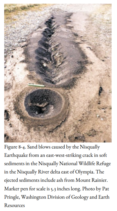
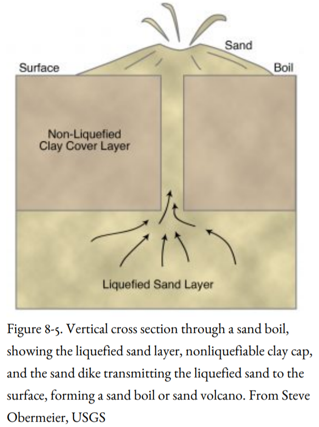
Perhaps the most spectacular expression of liquefaction, as observed by Norris on Harbor Island, occurs when watery sand vents to the surface through a clay cap or pavement, where it can spout up in the air like a fountain or geyser for minutes to hours after the mainshock, leaving a low crater or mound (sand boil) after the fountain has died down (Figure 8-4). Excavation of sand boils by a backhoe or bulldozer reveals a vertical filling of sand within the clay cap, called a sand dike (Figure 8-5). The sand dike marks the place where sand at depth has vented to the surface. The presence of sand dikes in sediments, for example, those found in an excavation beneath the Oregon Convention Center in Portland, is used as evidence for prehistoric earthquakes, although an alternative hypothesis holds that the sand dikes are related to the Missoula Floods of latest Pleistocene age.
The liquefaction susceptibility of sand can be determined by standard geotechnical engineering tests such as the Standard Penetration Test. During this test, a sampling tube is driven into the ground by dropping a 140-pound weight from a height of thirty inches (okay, it isn’t rocket science, but it works because every foundation engineer does it exactly the same way). The penetration resistance is the number of blows (number of times the weight is dropped) it takes to drive the sampler one foot into the soil. A low penetration resistance would be fewer than ten blows per foot; a high resistance would be greater than thirty blows per foot. Liquefiable sands have a very low penetration resistance; it’s very easy to drive the sampling tube into the sand.
Liquefaction can be triggered by earthquake accelerations as low as 0.1 g. It has been observed with earthquakes with magnitudes as low as 5, and it becomes relatively common with larger magnitudes. Liquefaction is more extensive with a longer duration of shaking, which is itself related to a large moment magnitude.
Much of the severe damage in the Marina District of San Francisco during the 1989 earthquake was due to liquefaction of the artificial fill that had been emplaced after the 1906 earthquake. Sand boils erupted into townhouse basements, streets, yards, and parks. Lateral spreading of the ground surface broke underground utility lines, leaving about a thousand homes without gas or water. The gas was not shut off, and the broken gas lines caused large fires to break out.
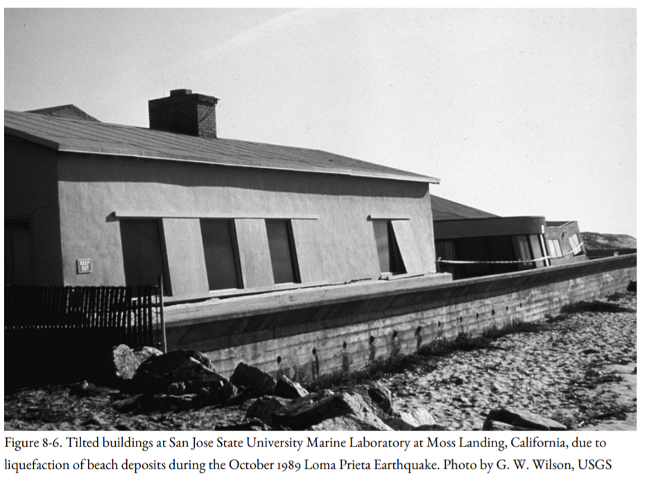
Liquefaction of beach deposits during the 1989 earthquake severely damaged the San Jose State University Marine Laboratory at Moss Landing (Figure 8-6). This illustrates the problem for cities like Seaside, Oregon, and Long Beach, Washington, built on sand bars.
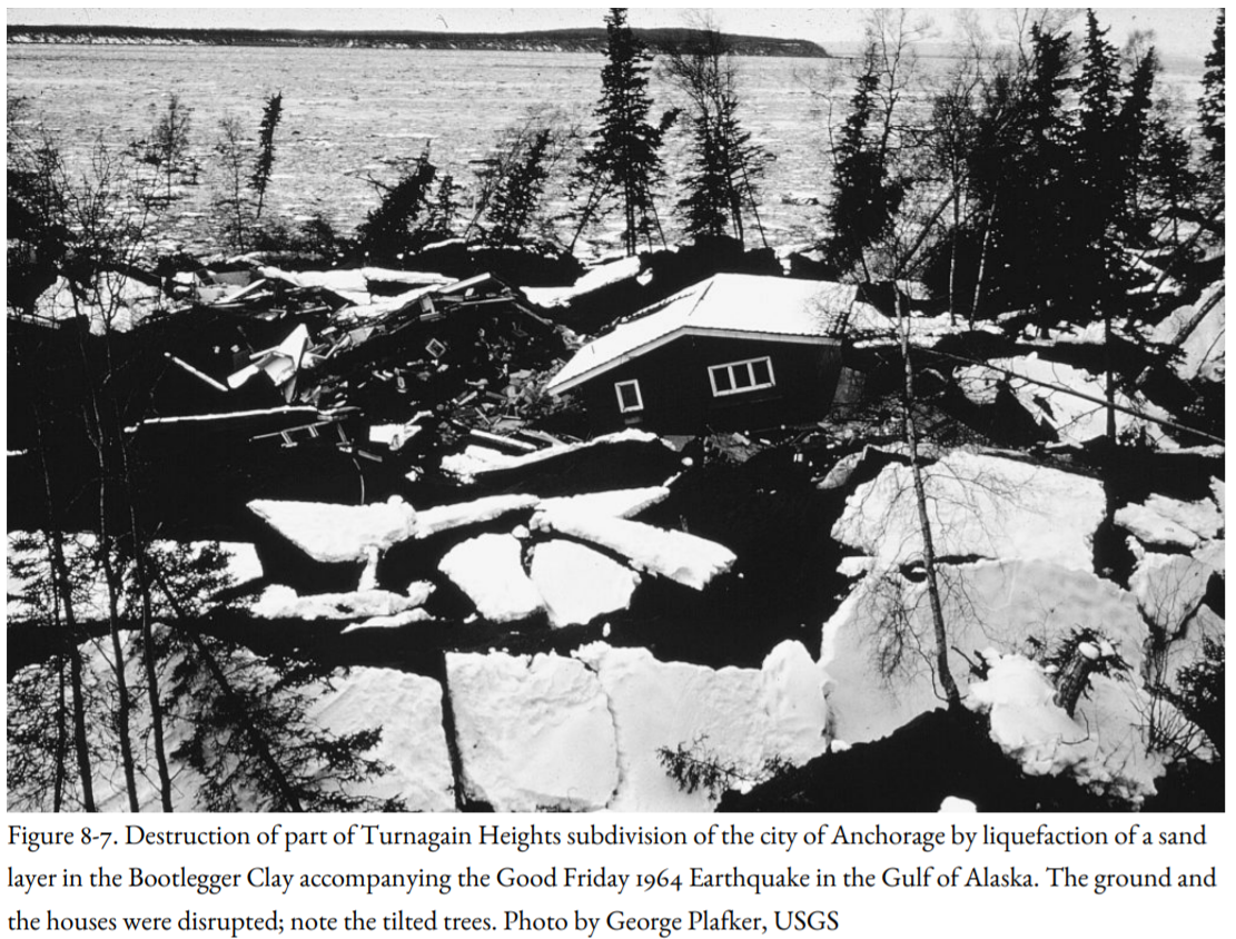
Liquefaction during the Good Friday Earthquake of 1964 in Alaska destroyed part of the new Turnagain Heights subdivision of Anchorage, situated on a thirty-foot bluff overlooking Cook Inlet (Figure 8-7). Earthquake waves liquefied a layer of sand and clay, causing part of the subdivision to break up and slide toward the bay. Homes, patios, streets, and trees tilted at weird angles, and gaping chasms opened, swallowing up and burying alive two small children. One house slid more than twelve hundred feet toward the sea, destroying itself as it did so. The instability of the water-saturated layer within the Bootlegger Cove Clay had been pointed out in a report by the USGS in 1959, five years before the earthquake, but this information evidently had no influence on development plans for Turnagain Heights.
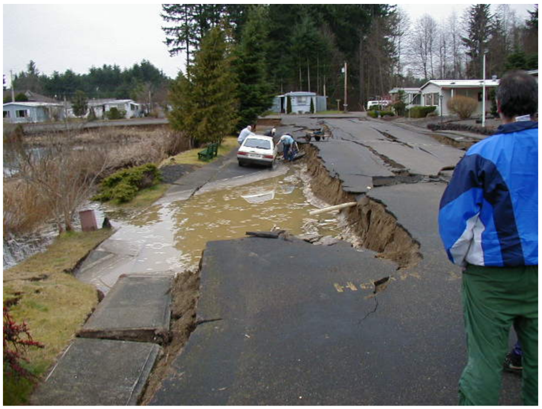
During the Puget Sound earthquakes of 1949 and 1965, 25 percent of the damage may have been caused by liquefaction. Drawbridges across the Duwamish Waterway in Seattle were disabled during both earthquakes. The distance between the piers in the main span of the Spokane Street Bridge was shortened by six to eight inches due to a lateral spread, jamming the drawbridge in the closed position. Geysers of sandy water were reported in 1949 at Longview, Centralia, Puyallup, and Seattle, and a large part of a sandy spit jutting into Puget Sound north of Olympia disappeared in 1949, probably due to liquefaction of the sand. Sediments beneath a mobile home park at Tumwater, Washington, liquefied during the Nisqually Earthquake, as they had in the earlier 1949 and 1965 earthquakes (Figure 8-8). Severe liquefaction also occurred in the delta of the Nisqually River east of Olympia (Figure 8-4), but much of that area is a wildlife refuge, an appropriate use for this unstable ground.

One of the arguments raised against a seismic origin of the buried marsh deposits on the Pacific coast is the rarity of liquefaction features such as sand dikes. However, many of these marshes are not underlain by clean sand. Pleistocene beach sand may underlie the Holocene marsh sequences, but if so, it is probably too consolidated and too deeply buried to undergo liquefaction.
On the other hand, liquefaction features are common on low islands in the tidal reaches of the Columbia River between Astoria, Oregon, and Kalama, Washington (Figure 8-9). These islands are flat, poorly drained, and swampy, and large parts of them are submerged during very high tides. Steve Obermeier of the USGS examined steep banks sculpted by the river and found that the islands are composed mainly of soft clay-rich silt, locally containing volcanic ash layers from Mt. St. Helens. Radiocarbon dating and correlation of the ash to a dated Mt. St. Helens ash indicate that the silt is less than one thousand years old.
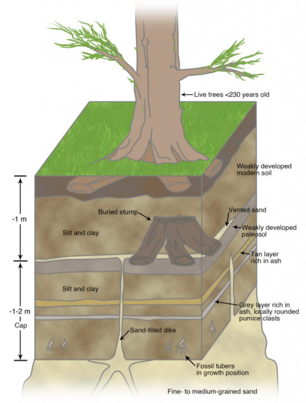
The silt layers are cut by hundreds of sand dikes (Figure 8-9), widest on islands near Astoria, and progressively narrower on islands upriver. These sand dikes were emplaced prior to the oldest trees now found on the islands, which are less than two hundred and thirty years old based on tree-ring dating. For this reason, Obermeier suggests that the dikes were probably emplaced during the great Cascadia Subduction Zone Earthquake of A.D. 1700. The dikes are present in the islands of the Columbia River because a source of river sand may lie just below the silt layer.
Curt Peterson of Portland State University has found that the late Pleistocene marine terrace deposits of the coast between central Washington and northern California contain abundant dikes, some as thick as three feet, evidence for strong earthquake shaking. The source for these dikes is the beach sand marking the base of the terrace. As stated earlier, nearly all examples of liquefaction during historical and late Holocene times involve sand sources that are Holocene in age, not Pleistocene. The sand dikes in the Pleistocene terrace deposits must have been generated by Pleistocene subduction-zone earthquakes, slightly younger than the terrace material in which they are found.
The potential for liquefaction can be reduced by various foundation-engineering techniques to strengthen the soil. These techniques include driving deep piles or piers through the liquefiable layer, emplacing concrete grout through weak layers, or even replacing liquefiable sediments with earth materials not subject to liquefaction. Sloping areas with a potential for lateral spread can be buttressed in the downslope direction. Such solutions are expensive, but they were shown to work during the Loma Prieta Earthquake of 1989. The Marina District suffered greatly from liquefaction, but sites in the San Francisco Bay Area that had received foundation-engineering treatment, including Treasure Island, Emeryville, Richmond, Union City, and South San Francisco, had little or no damage to the ground or to structures.