
5.6.8: Eastern Washington and Northeastern Oregon
- Page ID
- 5986

Overview
John McBride and his partner, Jack Ingram, were in trouble with the law. Contemporaries referred to them as “border ruffians . . . scoundrels who for pure cussedness could not be excelled anywhere on the border,” probably a compliment in the Washington Territory in 1872. Things had started out well; they had set up the first trading post in Wenatchee. But they were caught selling liquor to the Indians, and this got them arrested in Yakima. They bribed the prosecutor and were set free, but John McBride was then rearrested by federal marshals in Walla Walla, and he posted bond. He and Ingram had sold the trading post and were living in a cabin west of the Columbia River near the Wenatchee River while awaiting trial.
In the early morning hours of December 15, 1872, they were awakened by a loud noise, as if the stove had fallen over. As they were pulling on their clothes, they were thrown to the floor, and they realized that they were experiencing an earthquake. They made their way to the Wenatchee trading post, six miles away, where they found the new owners in a state of confusion, with sacks of flour thrown about and damage to the roof and upper logs of the cabin and to the kitchen. Great masses of earth came down from the hills, and the gulches were filled with debris. A group of Spokane Indians crowded around the white settlers, crying out that the world was coming to an end.
North along the Columbia River, a fifteen-year-old Indian boy, Peter Wapato, told of a landslide at Ribbon Cliff near Winesap (present-day Entiat) that dammed the Columbia River for several hours. This landslide was also reported by the Indians to a settler, Elizabeth Ann Coonc, camped downstream. Decades later, geologist I. C. Russell of the USGS would describe this landslide at a place that became known as Earthquake Point. The Indians called it Coxit (Broken-off) Point.
Chilliwack and Lake Osoyoos, B.C., and Snoqualmie Pass and Kittitas Valley, Washington, reported intensities of VII. Port Townsend, Seattle, Olympia, Vancouver, and Walla Walla, Washington, and Victoria, B.C., experienced intensities of VI.
A century later, the 1872 earthquake was the subject of great speculation because of plans for nuclear power plants by the Washington Public Power Supply System and Seattle City Light. The epicenter was variously located in the north Cascades, in the western foothills of the north Cascades, even in British Columbia, with magnitude estimates as high as 7.4. Bill Bakun of the USGS and his colleagues used the distribution of felt reports to locate the epicenter near Entiat and to estimate the magnitude as MI 6.8 (see Chapter 3 and Figure 2-6a), which made it the largest historical crustal earthquake in the Pacific Northwest except for Vancouver Island.
No source fault has been found. The eastern edge of the North Cascades near the Columbia River continues to be a source of small earthquakes, including an earthquake of M 5-5.4 on August 5, 1951, near Chelan. If there is something special about the Entiat region that should cause it to be more seismogenic than other areas, it is not known what it is.
On June 25, 2001, Spokane was rattled by a very shallow magnitude 3.7 earthquake that was followed by several aftershocks lasting into August. The distribution of the aftershocks suggested that they originated on a fault called the Hangman or Latah Creek fault, although no surface rupture related to these earthquakes was found. Such earthquakes are referred to as an earthquake swarm, in which there is a series of small earthquakes rather than a mainshock. Another earthquake swarm was recorded in 1987 in the Columbia Plateau near Othello, Washington, with more than two hundred events over a period of about a year. Like the 1872 earthquake, these could not be assigned to a specific fault.
The largest earthquake to strike northeastern Oregon shook the Milton-Freewater area shortly before midnight on July 16, 1936 (Figure 6-20). This earthquake has been given a magnitude as high as 6.1 and maximum intensity of VIII, although a recent study assigned it an intensity magnitude of MI 5.1 to 5.5 and maximum intensities of only VI. It was preceded by two foreshocks and followed by many aftershocks. The damage was reported in Milton-Freewater, Umapine, and Stateline, Oregon, and it was strongly felt in Walla Walla, Washington. Chimneys were damaged, houses were moved off their foundations, and liquefaction, as well as landslides, were reported.
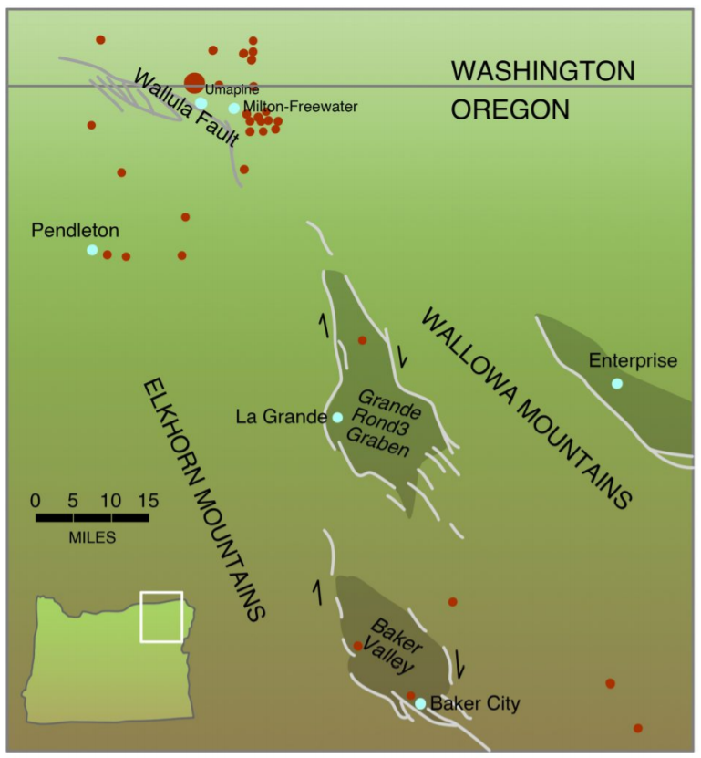
As in the previous examples, no source fault was immediately found. But in this case, a possible culprit has been identified: the Olympia-Wallowa Lineament, otherwise known as the OWL (Figure 6-21). This subtle structural alignment can be traced from the Olympic Peninsula across the Cascades and Hanford Reservation to the Wallowa Mountains in northeastern Oregon. Geologists have had difficulty in mapping the OWL on the ground, even though a straight-line feature can be observed from space (Fig. 6-22). However, geology students from Whitman College at Walla Walla found evidence that a branch of this structure may cut deposits only a few thousand years old. The Wallula Fault Zone cutting the Columbia River Basalts near Milton-Freewater could be part of the OWL (Figure 6-21), and one branch, the Umapine Fault, may have evidence of Holocene activity.
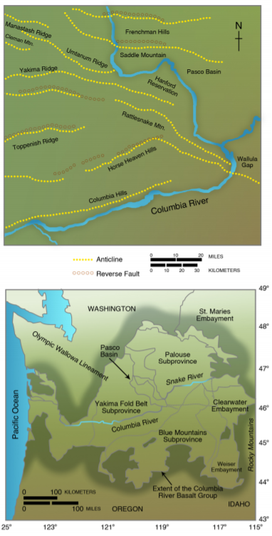
The southeast end of the OWL is the linear northeast range front of the high Wallowa Mountains, Oregon’s version of the Swiss Alps, although glacial moraines 140,000 years old do not appear to be cut by a range-front fault. Other faults mark the boundaries of basins within the Blue Mountains, including Grande Ronde Valley containing the city of La Grande, and Baker Valley containing Baker City (Figure 6-20). The Baker Valley Fault at the base of the Elkhorn Mountains has evidence of Late Quaternary (although not Holocene) displacement. The West Grande Ronde and East Grande Ronde faults also have evidence of Late Quaternary movement. Both faults are expressed in tectonic topography. Further southeast, other faults coincide with a zone of high seismicity near the Snake River in both Oregon and Idaho.