
3.19: Paleomagnetism and the Study of the Seafloor
- Page ID
- 9843

Paleomagnetism and the Study of the Seafloor
Earth's magnetic field has been a curiosity since ancient times. The magnetic compass was first invented as early as the Chinese Han Dynasty (about 206 BC). The compass was used during China’s Song Dynasty for military navigation by 1044 AD, and for maritime navigation by about 1117 AD. Today, the source of the magnetic field is presumed to be from the movement of molten iron and metals in the earth's core. The spinning of these liquid metals produces electric currents in the same manner as an electric coil produces a magnetic field. The magnetic field extends into space (see Figure 3.11). Over time, these currents fade, change direction, or intensify elsewhere, causing the magnetic poles to migrate or reverse the magnetic polarity of the entire planet (events called magnetic reversals).
Magnetometers (devices used to detect and measure the strength of magnetic fields) were used in World War II to search for submarines. It was noted from these investigations that the seafloor preserved large magnetic anomalies that lined up parallel the Mid-Atlantic Ridge (Figure 3.32). These investigations showed that the Earth's magnetic field has reversed many times through Earth history; magnetic reversals happened over periods ranging from thousands to millions of years. The chronology of magnetic reversals through geologic time are now well know.
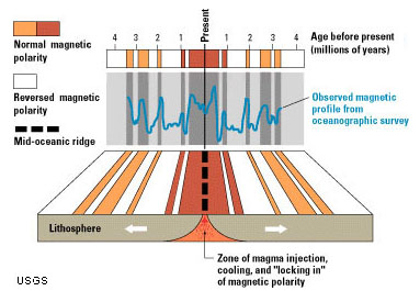
Figure 3.32. Mapping of the seafloor with magnetometers revealed lines of magnetic reversals on opposite sides of mid-ocean ridges. (USGS)
Paleomagnetism is the study of the fixed orientation of a rock's magnetic minerals as originally aligned at the time of the rock's formation (simply, old magnetism). Paleomagnetism is usually the result of thermoremanent magnetization (magnetization that occurs in igneous rocks as they cool below a certain temperature (called the Curie Point). As rocks (with iron in them) solidify, the magnetism direction points to the magnetic pole (which is currently north).Igneous rocks may keep their magnetic orientation they obtain at the time they form (if they are not altered). This magnetic signature is preserved, even if the landmass the magnetic rocks are on is moving. Mapping of the seafloor with magnetometers revealed lines of rock preserving history of magnetic reversals running parallel to the mid-ocean ridges [first published by Vine & Matthews, 1963] (Figure 3.33). With decades of studies of paleomagnetism of seafloor rocks and volcanoes around world the chronology of magnetic reversals through geologic time are now well known.
Paleomagnetism studies provide important data for resolving the age of rocks, where they formed, and where they have traveled over time. Fundamental information about the formation of new oceanic crust and explains the migration of landmasses over time. Paleomagnetism studies are fundamental to the theory of seafloor spreading.
Seafloor Spreading
Seafloor spreading is the processes associated with the formation of new areas of oceanic crust, which occurs through the upwelling of magma at mid-ocean ridges and its subsequent outward spreading movement on either side. As new rock forms along spreading centers it becomes attached to the lithospheric plates on either side of the spreading centers. Because the Earth's magnetic field is reversing frequently through geologic time, the rocks forming and moving away from spreading centers preserve the pattern of preserved magnetic orientation. This pattern turns out to be mappable (Figures 3-32 and 3-33).
Paleomagnetic studies of the world ocean basin resulted in the discovery of mid-ocean ridges and spreading centers. These undersea mountain ridges extend for 10s of thousands of miles beneath portions of the global ocean basins (see Figure 3.18, 3-30, and 3-36 below). Seafloor spreading became a mechanism to explain continental drift. However, seafloor spreading alone does not explain the formation of continental landmasses through geologic time.
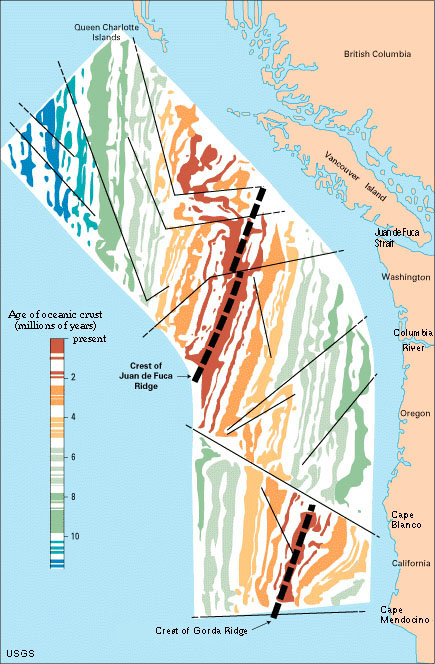
Figure 3.33. West Coast magnetic reversals reveal the location of spreading centers and fault boundaries in the ocean basin offshore of California, Oregon, Washington, and British Columbia