
3.9: Earthquakes, Faults, and Earthquake Faults
- Page ID
- 9826

Earthquakes, Faults, and Earthquake Faults
An earthquake is ground shaking caused by a sudden movement on a fault, by a volcanic disturbance, a landslide, or a explosion (natural or man made).
A fault is a fracture or crack along which two blocks of rock slide past one another. This movement may occur rapidly, in the form of an earthquake, or slowly, in the form of creep.
Earthquakes occur somewhere around the world every hour of every day. Most are too small to even feel. However, large-magnitude, damaging earthquakes happen somewhere around the world almost every year. Large earthquakes can cause widespread chaos, destruction, and death. Earthquakes are associated with faults, but not all faults currently generate earthquakes (some faults may have been active long ago, but are now inactive). Faults range is size from small fractures in a local outcrop to great fault systems that can extend for thousands of miles.
Features Associated With Faults
A fault is a fracture or crack along which two blocks of rock slide past one another. This movement may occur rapidly, in the form of an earthquake, or slowly, in the form of creep (Figure 6.18). Types of faults include strike-slip faults, normal faults, reverse faults, thrust faults, and oblique-slip faults. Faults can be small to large complex systems of interlinking faults and may change form one kind of fault in one location to another kind somewhere else. Many faults are associated with folds. Faults split, bifurcate, merge, or can peter out over distances, sometime forming complex systems of fractures.
The relative motion of faults (one side to the other) is described in terms of relationship of a hanging wall and foot wall (see normal fault and reverse fault examples in Figure 3.13).
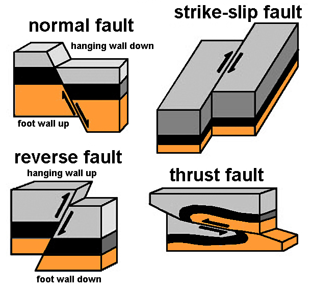 Figure 3.13. Block diagrams illustrating common types of faults: normal fault, reverse fault, strike-slip fault, and thrust fault. Offset strata illustrates the relative motion of the foot wall to the hanging wall of each type of fault.
A foot wall is the underlying block of a fault having an inclined fault plane.
A hanging wall is the block (rocks) on the upper side of an inclined fault plane.
Simply described here—if a fault is exposed well enough to see that the fault plane is inclined, the side you could stand on is called the foot wall. The side you could hang from without your feet touching the ground is the hanging wall. For instance, on a normal fault, the hanging wall has moved down relative to the foot wall. On a reverse fault, the hanging wall has moved up relative to the foot wall.
Terms Used To Describe Earthquakes
A rupture zone is the area of the Earth through which fault movement occurred during an earthquake. For large earthquakes, the section of the fault that ruptured may be several hundred miles in length. Ruptures may or may not extend to the ground surface.
A focus is the point below the Earth's surface where seismic waves originate during an earthquake (Figure 3.14).
An epicenter is the point on the Earth’s surface above the point at depth in the Earth’s crust where an earthquake begins.
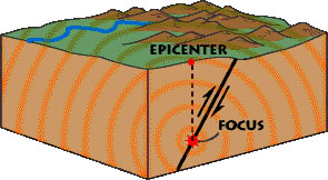 Figure 3.14. Diagram illustrating the focus and epicenter of an earthquake along a fault.
Seismic Waves
Seismology is the study of earthquake shock waves as they pass through the earth. Seismology is the science that helped resolve many questions about the internal structure of the earth.
Seismic waves are shock wave and vibrations in the Earth which issue from the focus of an earthquake. Seismic waves are a result of an earthquake, impact, or explosion, or some other process that imparts low-frequency acoustic energy into the earth. (Figures 3-14 and 3-15).
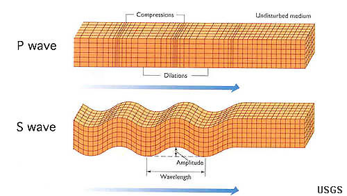 Figure 3.15. Earthquake waves include:
P-compression waves and
S-shear waves.
P-waves move faster than S-waves and are first to be felt. The S-waves arrive next and produce the majority of shaking in an earthquake.
Two Types of Seismic Waves: Surface Waves and Body Waves
• Surface waves travel on the surface.
• Body waves travel through the earth.
There are two types of body waves: P waves and S waves
P (primary) waves are compressional and cause rocks to move back-and-forth parallel to the direction of wave movement.
• P waves travel faster than S waves through denser and more compact elastic materials (solid, liquids, gases).
S (shear) waves have a shear effect and cause rocks to move back-and-forth perpendicular to the direction of wave movement.
• S waves are slower than P waves and travel only through solid mater, not liquids or gases. S wave speed varies depending on materials, but typically they only move about 60-70% as fast as P waves in the upper part of the Earth's crust. The fact that S waves travel through all parts of the Earth except the outer core tell us that the outer core is the only part of the Earth's interior that is fully liquid.
Locating Earthquakes With Seismographs
A seismograph is a device used to record earthquake shaking and is used to determine the distance from an earthquake focus, and the magnitude and intensity of earthquakes. Data from numerous seismographs linked together in networks are used to determine the focus, epicenter, extent of rupture, and amount of shaking in a region caused by an earthquake. A minimum of 3 seismographs are needed to determine the epicenter of an earthquake (Figure 3.15).
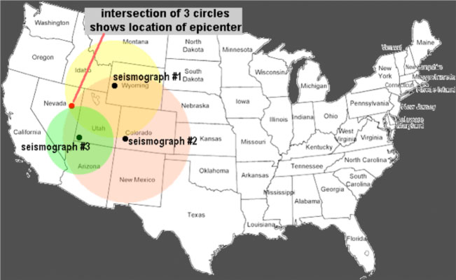
Figure 3.15. At least three seismographs are needed to locate the epicenter of an earthquake. A single seismograph can only tell you how far away an earthquake occurred, but not in which direction.
Note that the Global Seismographic Network consists of thousands of seismographs around the world, so information about earthquakes can be calculated quite precisely.
In earthquake-prone regions, many seismographs have been installed, along with related fault motion sensors that measure stress and strain buildup along faults or the extremely slow creep of some faults, and even changes in the gas content, water level changes, and electrical properties of rocks in the vicinity of fault zones. The more measurement devices, the better detail can be determined about the nature of earthquake-prone fault systems.
Describing Earthquakes: Earthquake Magnitude and Earthquake Intensity
Earthquake magnitude (M) is a numeric measure that represents the size or strength of an earthquake, as determined from seismographic observations. The Richter scale is a numerical (logarithmic) scale for expressing the magnitude of an earthquake on the basis of seismograph oscillations. Today earthquake intensity is recorded with a Moment Magnitude Scale (MMS) which is based on the seismic moment of the earthquake, which is equal to the rigidity of the Earth multiplied by the average amount of slip on the fault and the size of the area that slipped. Richter scale and moment magnitude scales are similar, but the MMS scale is more precise (Figure 3.13).
Earthquake intensity (I) is a measure of ground shaking describing the local severity of an earthquake in terms of its effects on the Earth’s surface and on humans and their structures. The Modified Mercalli Intensity (MMI) scale, which uses Roman numerals, is one way scientists measure intensity (Figure 3.16).
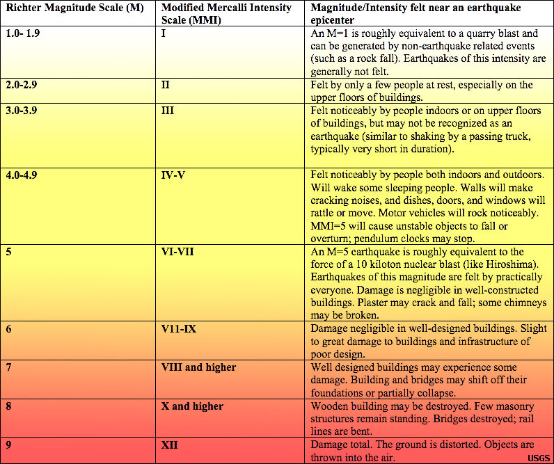 Figure 3.16. Comparison of earthquake magnitude (MMS) and intensity (MMI) scales (USGS)
Video: Historic Earthquakes compared (Pacific Tsunami Warning Center)
Video: Earthquakes of the First 15 Years of the 21st Century (US NWS Pacific Tsunami Warning Center)