Geosciences LibreTexts

2.32: Where are rocks of different ages exposed in the United States?

  • Page ID
    9801
  • \( \newcommand{\vecs}[1]{\overset { \scriptstyle \rightharpoonup} {\mathbf{#1}} } \) \( \newcommand{\vecd}[1]{\overset{-\!-\!\rightharpoonup}{\vphantom{a}\smash {#1}}} \)\(\newcommand{\id}{\mathrm{id}}\) \( \newcommand{\Span}{\mathrm{span}}\) \( \newcommand{\kernel}{\mathrm{null}\,}\) \( \newcommand{\range}{\mathrm{range}\,}\) \( \newcommand{\RealPart}{\mathrm{Re}}\) \( \newcommand{\ImaginaryPart}{\mathrm{Im}}\) \( \newcommand{\Argument}{\mathrm{Arg}}\) \( \newcommand{\norm}[1]{\| #1 \|}\) \( \newcommand{\inner}[2]{\langle #1, #2 \rangle}\) \( \newcommand{\Span}{\mathrm{span}}\) \(\newcommand{\id}{\mathrm{id}}\) \( \newcommand{\Span}{\mathrm{span}}\) \( \newcommand{\kernel}{\mathrm{null}\,}\) \( \newcommand{\range}{\mathrm{range}\,}\) \( \newcommand{\RealPart}{\mathrm{Re}}\) \( \newcommand{\ImaginaryPart}{\mathrm{Im}}\) \( \newcommand{\Argument}{\mathrm{Arg}}\) \( \newcommand{\norm}[1]{\| #1 \|}\) \( \newcommand{\inner}[2]{\langle #1, #2 \rangle}\) \( \newcommand{\Span}{\mathrm{span}}\)\(\newcommand{\AA}{\unicode[.8,0]{x212B}}\)

    Where are rocks of different ages exposed in the United States?

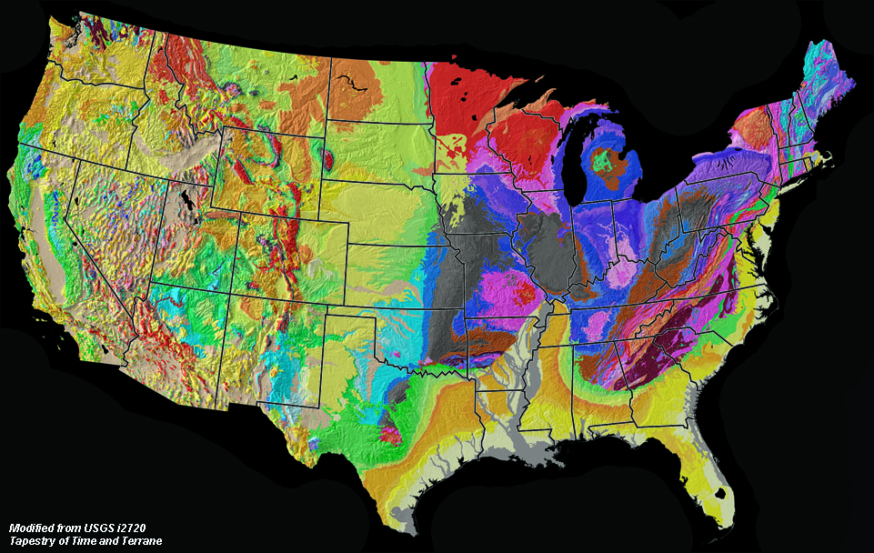
    Rocks of all geologic ages are exposed in different parts of the United States. Figure 2.83 is a geologic map of the conterminous United States, and Figure 2.84 is the geologic map legend that shows colors associated with regions where rocks of different ages are exposed at the surface. Earth scientists use geologic maps like these to locate areas where they may go study the fossil record where rocks of different ages (and the fossils they contain) occur. Each region of the country has unique fossil record. The best place to start an investigation is to visit museums, universities, and government organizations that host fossil and rock collections in the vicinity where rocks are exposed. Learn more about the regional geology and natural resources of the United States on this link: Regional Geology of the United States.

    Geologic Map of the United States (48 states) Geologic age units associated with the geologic map of the United States.
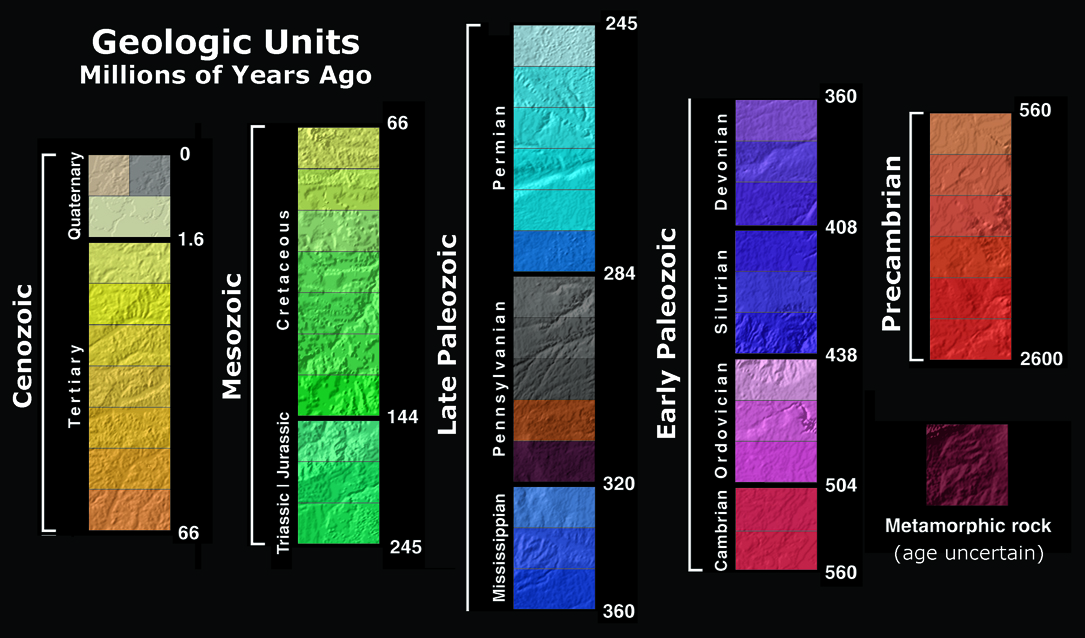
    Figure 2.83. Geologic map of the United States. Figure 2.84. Geologic ages of bedrock on the geologic map.

    Selected comprehensive websites for paleontology and evolution:

    U.C. Berkeley Museum of Paleontology website
    http://www.ucmp.berkeley.edu/exhibits/index.php

    American Museum of Natural History
    https://www.amnh.org/our-research/paleontology

    Smithsonian Institution, Department of Paleobiology
    http://paleobiology.si.edu/


    This page titled 2.32: Where are rocks of different ages exposed in the United States? is shared under a not declared license and was authored, remixed, and/or curated by Miracosta Oceanography 101 (Miracosta)) via source content that was edited to the style and standards of the LibreTexts platform; a detailed edit history is available upon request.