
1.43: Unconformities- Gaps in the Geologic Record
- Page ID
- 9765

Unconformities: Gaps in the Geologic Record
Following on the Law of Original Horizontality and Law of Superposition, both Hutton and Lyell recognized erosional boundaries preserved between rock layers that represent gaps in the geologic record. They named these gaps unconformities. An unconformity is a surface between successive strata that represents a missing interval in the geologic record of time, and produced either by: a) an interruption in deposition, or b) by the erosion of depositionally continuous strata followed by renewed deposition. It should be noted that the unconformable gaps in the geologic record in one region may be represented by sedimentary deposits in another region. Through time, geologists and paleontologists have been able to correlate rock formations and associated unconformities across large regions and even across oceans to other continents. Research over the past two centuries have provided information that in many of the gaps, making a more complete history of the geologic record.
 |
 |
| Figure 1.105. Types of unconformities (boundaries between layered rocks). | Fig. 106. Layered sedimentary rocks in a sea cliff in Encinitas, CA showing an angular unconformity (evidence of a gap in the geologic record). |
Several types of unconformable boundaries are recognized (Figure 1.107):
- nonconformity—an unconformity between sedimentary rocks and metamorphic or igneous rocks when the sedimentary rock lies above and was deposited on the pre-existing and eroded metamorphic or igneous rock
. - angular unconformity—an unconformity where horizontally parallel strata of sedimentary rock are deposited on tilted and eroded layers, producing an angular discordance with the overlying horizontal layers
. - disconformity—an unconformity between parallel layers of sedimentary rocks which represents a period of erosion or non-deposition.
- conformable boundary—an arrangement where layers of sedimentary strata are parallel, but there is little apparent erosion and the boundary between two rock layer surfaces resemble a simple bedding plane.
 |
 |
 |
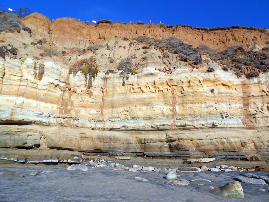 |
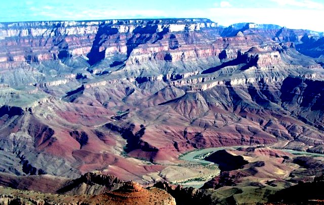
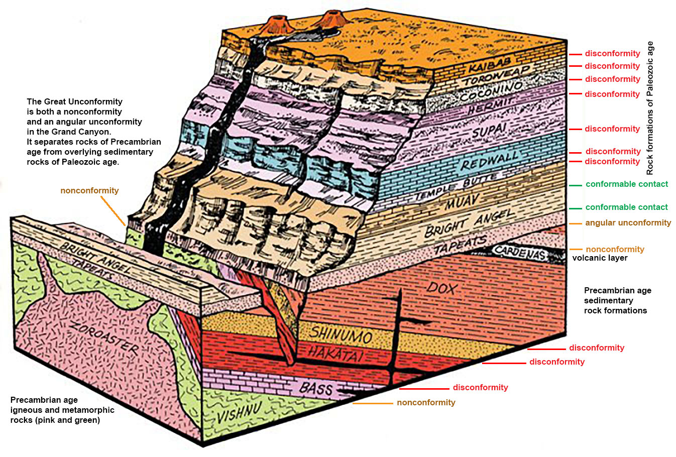
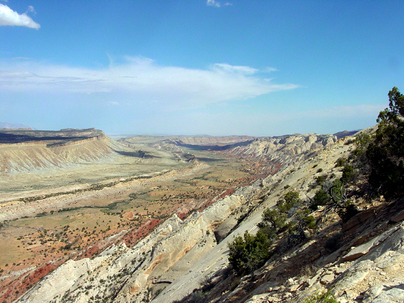
| Figure 1.107. Rock formations exposed in the Grand Canyon were originally deposited in different stages during the Precambrian and Paleozoic Eras. Some layers were deposited in shallow oceans, others layers accumulated on land. | Figure 1.108. A block diagram of the Grand Canyon shows the names of rock formations separated by unconformities (representing gaps in time when sediments were not deposited). Can you spot an angular unconformity? | Figure 1.109. Rock formations like these in Utah record information about 100 million years of Mesozoic Era of the region. These sedimentary rock layers were originally deposited horizontally, but were tilted by later mountain-building (tectonic) activity. | Figure 1.110. Layers of sedimentary rock formations with unconformities are exposed in many locations along the California coastline. For example, these sedimentary rock formations are exposed at the Dog Beach in Del Mar, CA. |
How Do Unconformities Form?
Unconformities are caused by relative changes in sea level over time. Wave erosion wears away materials exposed along coastlines, scouring surfaces smooth. On scales of thousands to millions of years, shorelines may move across entire regions. Erosion strips away materials exposed to waves and currents. New (younger) material can be deposited on the scoured surface. Shallow seas may flood in and then withdrawal repeatedly. Long-lasting transgressions can erode away entire mountain ranges with enough time.
A transgression occurs when a shoreline migrates landward as sea level (or lake level) rises.
A regression occurs when a shoreline migrates seaward as sea level (or lake level) falls (Figure 3.111).
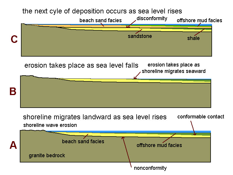 Figure 3.111. Unconformities can form by the rise and fall of sea level. Erosion strips away materials exposed to waves and currents. A rise in sea level causes a transgression which creates space underwater for sediments to be deposited. New (younger) material is deposited on the scoured surface. When sea level falls it causes a regression, and sediments are not deposited or are eroded away.
Sea level changes may be caused by region uplift or global changes in sea level, such at the formation or melting of continental glaciers. Whatever the cause of sea level change, when sea level falls, sediments are eroded from exposed land. When sea level rises, sediments are typically deposited in quiet water settings, such as on shallow continental shelves or in low, swampy areas on coastal plains.
Some unconformities represent great gaps in time. For example, the Great Unconformity in the lower Grand Canyon illustrates where a great mountain range existed in the region during Precambrian before erosion completely stripped the landscape away back down, eventually allowing seas to flood over the region again in Cambrian time (see the angular unconformity below the Tapeats Formation in Figure 1.108). The gap in the geologic record in some locations along the Great Unconformity represents billions of years.