Geosciences LibreTexts

9.7.1: Introduction

  • Page ID
    16409
  • \( \newcommand{\vecs}[1]{\overset { \scriptstyle \rightharpoonup} {\mathbf{#1}} } \) \( \newcommand{\vecd}[1]{\overset{-\!-\!\rightharpoonup}{\vphantom{a}\smash {#1}}} \)\(\newcommand{\id}{\mathrm{id}}\) \( \newcommand{\Span}{\mathrm{span}}\) \( \newcommand{\kernel}{\mathrm{null}\,}\) \( \newcommand{\range}{\mathrm{range}\,}\) \( \newcommand{\RealPart}{\mathrm{Re}}\) \( \newcommand{\ImaginaryPart}{\mathrm{Im}}\) \( \newcommand{\Argument}{\mathrm{Arg}}\) \( \newcommand{\norm}[1]{\| #1 \|}\) \( \newcommand{\inner}[2]{\langle #1, #2 \rangle}\) \( \newcommand{\Span}{\mathrm{span}}\) \(\newcommand{\id}{\mathrm{id}}\) \( \newcommand{\Span}{\mathrm{span}}\) \( \newcommand{\kernel}{\mathrm{null}\,}\) \( \newcommand{\range}{\mathrm{range}\,}\) \( \newcommand{\RealPart}{\mathrm{Re}}\) \( \newcommand{\ImaginaryPart}{\mathrm{Im}}\) \( \newcommand{\Argument}{\mathrm{Arg}}\) \( \newcommand{\norm}[1]{\| #1 \|}\) \( \newcommand{\inner}[2]{\langle #1, #2 \rangle}\) \( \newcommand{\Span}{\mathrm{span}}\)\(\newcommand{\AA}{\unicode[.8,0]{x212B}}\)

    Within the basin, the tide is strongly deformed by bottom friction and other non-linear effects associated with the basin geometry (see Sects. 5.7.3 and 5.7.4). This tidal distortion can either strengthen or weaken the magnitude of the maximum flood flow compared to the maximum ebb flow (flood versus ebb dominance) and causes an asymmetry between durations of the slack water periods as well. These asymmetries greatly impact the net movement of sediment, both sand and silt, and therewith the morphological development of the basin in time. As mentioned before, due to this feedback mechanism the basin in essence determines its own evolution (if we ignore external conditions such as sediment availability, storm surges and the tidal conditions at sea).

    截屏2021-11-30 下午9.35.12.png
    Figure 9.27: Hypsometric curves for two different basin types; the wetted basin surface area \(O(z)\) as a function of the water level. The left figure is representative of a situation with shallow channels and large intertidal storage areas. The right situation is the opposite; deep channels and small intertidal areas. Here the flats are defined as lying above MLW.

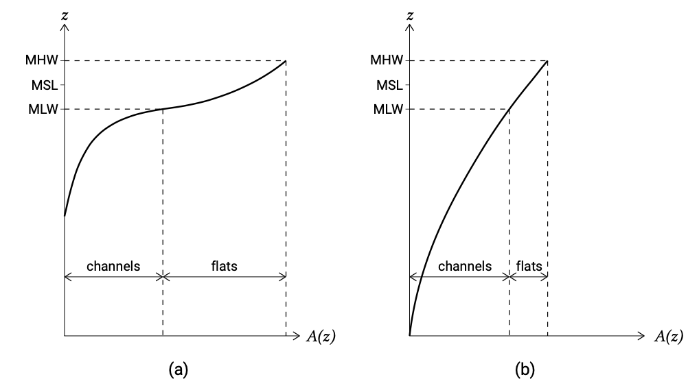
    So-called hypsometric5 curves give information about the depth of the channels and the extent of the flats (see Fig. 9.27). In Sect. 5.7.4, these parameters were found to control ebb- and flood-dominance in the following way:

    • A large tidal amplitude and shallow channels enhance flood-dominance;
    • A large intertidal storage volume (as compared to channel volume) enhances ebb-dominance.

    The import or export of sand is strongly steered by the velocity signal being flood-dominant or ebb-dominant, as we will see in Sect. 9.7.2.


    5. The term hypsometry refers to the topographical characteristics of tidal basins.


    This page titled 9.7.1: Introduction is shared under a CC BY-NC-SA 4.0 license and was authored, remixed, and/or curated by Judith Bosboom & Marcel J.F. Stive (TU Delft Open) via source content that was edited to the style and standards of the LibreTexts platform; a detailed edit history is available upon request.