
9.2.1: Bays, lagoons and estuaries
- Page ID
- 16396

Three distinct types of tidal basins can be discerned (Carter (1988), see Table 9.1 for a summary):
- Tidal lagoons are basins that are enclosed by wave-shaped coastal barriers islands or barrier spits. Almost 12% of the world’s coastline is made up of barriers, many of them enclosing lagoons. The Dutch Wadden Sea is a good example. Due to the presence of the barriers, the penetration of waves into the lagoons is limited. Water flows into the lagoon with the flood and out during the ebb through passes or inlets between the barrier islands. These narrow waterways are also called throats or gorges. In most cases the tidal fluxes in and out of the lagoon are balanced over a tidal period. Sometimes it is a sub-surface rather than a surface connection with the open sea that allows the water levels in the basin to be modulated by the tide. Where the basins proper are tide-dominated, the inlets to the basins experience both wave and tidal influence. Sediment tends to be finer in the more protected regions away from the entrances. The fresh water run-off is typically limited;
- In the absence of barrier islands, tidal bays are basins that are more open to the deep water of the sea or ocean. Bays have a limited fresh water run-off. The Baie de St. Michel is a good example. Waves can enter unhindered, but generally lose their energy not far from the entrance (mouth) before the shorelines in the bay are reached, due to depth-limited breaking (Sect. 5.2.5) and bottom friction;
- Estuaries are different from bays in that they experience a (strong) fresh-water run-off. Therefore, the seawater in these basins is measurably diluted by fresh-water. But unlike river mouths, estuaries are typically tide-dominated; the water motion in estuaries is controlled more by the tides than by the river discharge. Also, sedimentation is primarily controlled by import from the adjacent coastal region. The coarser sediment (sand) settles predominantly in the seaward regions, while the finer sediment (silt) settles in the more protected landward regions. The entrances of some estuaries may be constricted by the development of spits, shoals or barriers across their mouths, as a result of wave effects.
| Environment | Distinctive attributes |
Tidal bays
|
|
Tidal Lagoons
|
|
Estuaries
|
|
The three types of basins mainly differ in terms of the characteristics of the entrance and the importance of fresh-water run-off. The basins are either interlinked with the adjacent coast or barrier islands through tidal inlets, openings in the shoreline, such as between two barrier islands, or wider entrances such as estuary mouths. Fresh- water run-off and hence the interaction between salt- and fresh water is a fundamental characteristic of estuaries (see Intermezzo 9.1). Based on the degree of mixing of the two water masses, estuaries can be classified as stratified, partially mixed/stratified and mixed or homogeneous. One of the phenomena related to fresh-salt water mixing is the turbidity maximum. In the present version of these lecture notes we refrain from paying due attention to the mixing between fresh water and salt water, a topic which would require a rather extensive treatment. We therefore mostly assume a negligible influence of fresh-water run-off in this chapter.
In estuaries, there exists a transitional region between salt and fresh water. In the case of small and medium fresh water discharges the salt-fresh water transition region is located near the estuary head (the location of the river mouth). Seaward of the transition region the tidal water motion dominates and the water is mainly saline. More landward the river flow dominates and the water is mainly fresh. The pressure gradient associated with the density difference between the saline (of sea origin mainly) water and the upstream fresh river water drives a vertical flow circulation, the so-called estuarine circulation (see Fig. 9.1). When the fresh water meets the saline water, the less dense fresh water overrides the denser saline water. Hence, along the bottom the net (i.e. tidally averaged) flow is in the landward direction, while it is seaward along the surface. Note that wide estuaries may show little salinity variation with depth, but considerable variation with width; as a result of Coriolis, the denser flood and less dense ebb currents are concentrated along different banks.
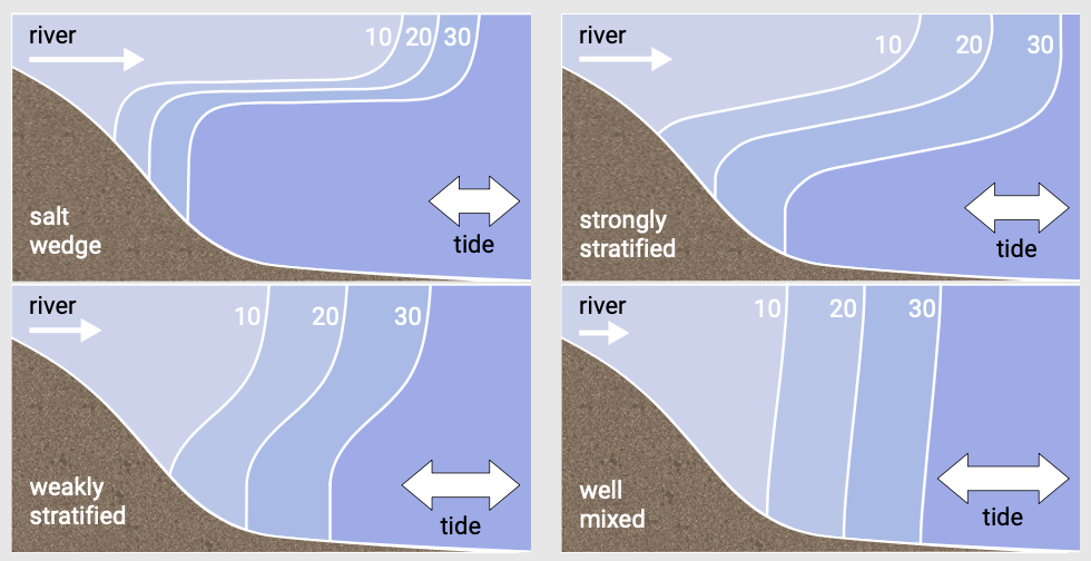
As suspended sediment concentrations are higher near the bed, estuarine circulation promotes sediment import. A related phenomenon is the formation of a turbidity maximum, which is the concentration of fine sediments not far from the end of a salt water wedge. It occurs since salt water stimulates the flocculation of clay particles being transported by the river.
When treating lagoons, we assume an approximately equal influx and outflux of water (as is the case for the Wadden Sea basins). This means that we exclude lagoons for which the seawater inflow exceeds the outflow due to evaporation. These lagoons are called sabkhas and are common on low-latitude arid coasts.
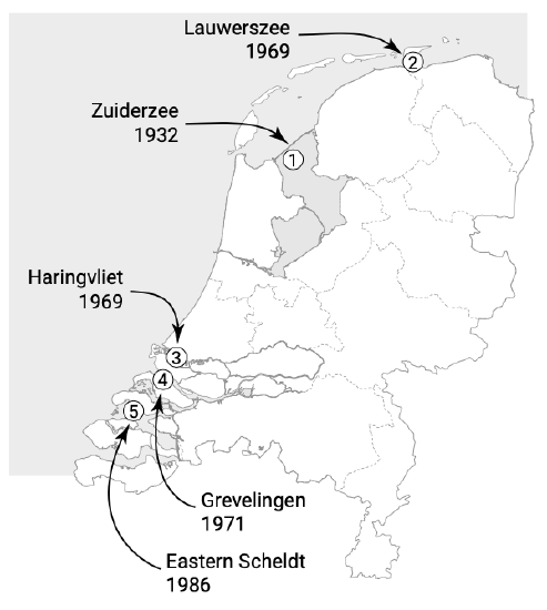
In these lecture notes we often use the two distinct types of Dutch coastal basins, the estuaries of the Southwest Delta1 and the Wadden Sea barrier inlet systems, to illustrate the above described differences. They are indicated in Fig. 9.2. Three of the estuaries in the Southwest Delta were partly or entirely closed as part of the Delta Works (numbers 3, 4 and 5 in Fig. 9.2). The Delta Works are a series of dams, sluices, locks, dikes and storm surge barriers built between 1950 and 1997 (Maeslant storm surge barrier) to protect a large area of land around the Southwest Delta from the sea. In the Dutch Wadden Sea system two closure barriers have also been constructed in the 20th century (numbers 1 and 2 in Fig. 9.2). The response to (semi-)closures of tidal basins is further discussed in Sect. 9.8.
1. The southwest coast of the Netherlands is often called our Delta Coast. It is here that Rhine, Meuse and Scheldt rivers exit to the North Sea. However, there is no real delta present and these rivers have mainly indirectly contributed to the Holocene formation of this coastal area; marine feeding (with reworked Pleistocene riverine sediments) was the major source of sediment.