Geosciences LibreTexts

8.4.6: Deltaic coastlines

  • Page ID
    16395
  • \( \newcommand{\vecs}[1]{\overset { \scriptstyle \rightharpoonup} {\mathbf{#1}} } \) \( \newcommand{\vecd}[1]{\overset{-\!-\!\rightharpoonup}{\vphantom{a}\smash {#1}}} \)\(\newcommand{\id}{\mathrm{id}}\) \( \newcommand{\Span}{\mathrm{span}}\) \( \newcommand{\kernel}{\mathrm{null}\,}\) \( \newcommand{\range}{\mathrm{range}\,}\) \( \newcommand{\RealPart}{\mathrm{Re}}\) \( \newcommand{\ImaginaryPart}{\mathrm{Im}}\) \( \newcommand{\Argument}{\mathrm{Arg}}\) \( \newcommand{\norm}[1]{\| #1 \|}\) \( \newcommand{\inner}[2]{\langle #1, #2 \rangle}\) \( \newcommand{\Span}{\mathrm{span}}\) \(\newcommand{\id}{\mathrm{id}}\) \( \newcommand{\Span}{\mathrm{span}}\) \( \newcommand{\kernel}{\mathrm{null}\,}\) \( \newcommand{\range}{\mathrm{range}\,}\) \( \newcommand{\RealPart}{\mathrm{Re}}\) \( \newcommand{\ImaginaryPart}{\mathrm{Im}}\) \( \newcommand{\Argument}{\mathrm{Arg}}\) \( \newcommand{\norm}[1]{\| #1 \|}\) \( \newcommand{\inner}[2]{\langle #1, #2 \rangle}\) \( \newcommand{\Span}{\mathrm{span}}\)\(\newcommand{\AA}{\unicode[.8,0]{x212B}}\)

    Built primarily from river-borne sediments, deltas form when the amount of sediment delivered at the mouth of a river exceeds the amount removed by waves and tidal currents (see Ch. 2). The main effect of waves and tides is to redistribute the sediment along the coast. Section 2.7.3 has discussed the classification of deltas based on the relative river, wave and tidal influence.

    截屏2021-11-16 下午10.10.15.png
    Figure 8.30: Developments of deltaic coastline with normally incident wave (no tidal influence). The river discharge is \(Q_r\) and the sediment discharge \(S_r\). The angle \(\phi\) is determined by the sediment discharge and wave conditions.

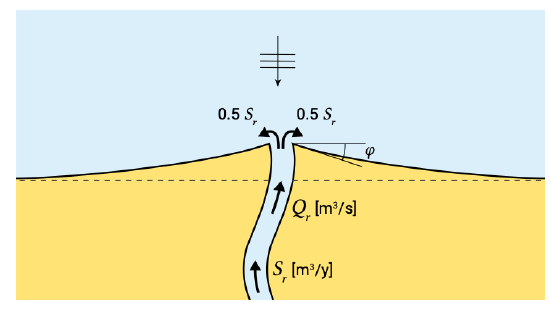
    Figure 8.30 shows the schematised development of a wave-dominated deltaic coastline (cf. Fig. 1.7). An equilibrium coastline position requires that all of the sediment supplied by the river is transported to the coastlines on either side of the river mouth by the wave-driven longshore currents. From the wave characteristics and the river sediment supply the equilibrium coastline orientation (see Fig. 8.30) can be calculated; at the delta mouth the angle \(\varphi\) with the ‘normally’ incident waves will be such that the longshore transport rate is equal to \(\tfrac{1}{2} S_r\).

    截屏2021-11-16 下午10.11.21.png
    Figure 8.31: Delta erosion after the sediment supply is cut-off. Due to wave-induced longshore transport gradients sediments are redistributed along the coast, resulting in erosion of the delta (cf. the development of a shoreline perturbation in Sect. 8.4.4).

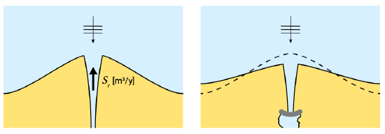
    Man-induced changes in the characteristics of the river (e.g. sand mining in the river bed, or damming of the river for irrigation or hydro-power purposes), might change the natural accreting tendency of the coast to an eroding tendency in the vicinity of the river outlet (see Fig. 8.31).

    截屏2021-11-16 下午10.12.45.png
    Figure 8.32: Senegal river delta.

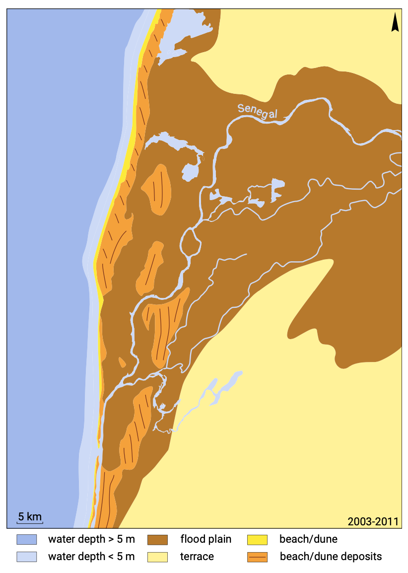
    For obliquely incident waves, the redistribution of the river sediment along the shore is asymmetric. Also, a sand spit can develop in these cases due to a strong longshore sediment transport. The process of spit formation was already described in Sect. 8.4.5. Section 2.7.3 gives examples of various wave-dominated deltas. The Ebro delta (Fig. 2.49) and the Senegal delta (Fig. 8.32) are examples of spit formation in a deltaic environment.


    This page titled 8.4.6: Deltaic coastlines is shared under a CC BY-NC-SA 4.0 license and was authored, remixed, and/or curated by Judith Bosboom & Marcel J.F. Stive (TU Delft Open) via source content that was edited to the style and standards of the LibreTexts platform; a detailed edit history is available upon request.