
4.2: The long trail of the Hawaiian hotspot
- Page ID
- 18234
Over the past 70 million years, the combined processes of magma formation, volcano eruption and growth, and continued movement of the Pacific Plate over the stationary Hawaiian "hot-spot" have left a long trail of volcanoes across the Pacific Ocean floor. The Hawaiian Ridge-Emperor Seamounts chain extends some 6,000 km from the "Big Island" of Hawaii to the Aleutian Trench off Alaska. The Hawaiian Islands themselves are a very small part of the chain and are the youngest islands in the immense, mostly submarine mountain chain composed of more than 80 volcanoes. The length of the Hawaiian Ridge segment alone, from the Big Island northwest to Midway Island, is about equal to the distance from Washington, D.C. to Denver, Colorado (2,600 km). The amount of lava erupted to form the Hawaiian-Emperor chain is calculated to be at least 750,000 cubic kilometers-more than enough to blanket the entire State of California with a layer of lava roughly 1.5 km thick.
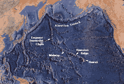
Map of part of the Pacific basin showing the volcanic trail of the Hawaiian hotspot-- 6,000-km-long Hawaiian Ridge-Emperor Seamounts chain. (Base map reprinted by permission from World Ocean Floor by Bruce C. Heezen and Marie Tharp, Copyright 1977.)
A sharp bend in the chain indicates that the motion of the Pacific Plate abruptly changed about 43 million years ago, as it took a more westerly turn from its earlier northerly direction. Why the Pacific Plate changed direction is not known, but the change may be related in some way to the collision of India into the Asian continent, which began about the same time.
As the Pacific Plate continues to move west-northwest, the Island of Hawaii will be carried beyond the hotspot by plate motion, setting the stage for the formation of a new volcanic island in its place. In fact, this process may be under way. Loihi Seamount, an active submarine volcano, is forming about 35 km off the southern coast of Hawaii. Loihi already has risen about 3 km above the ocean floor to within 1 km of the ocean surface. According to the hotspot theory, assuming Loihi continues to grow, it will become the next island in the Hawaiian chain. In the geologic future, Loihi may eventually become fused with the Island of Hawaii, which itself is composed of five volcanoes knitted together-Kohala, Mauna Kea, Hualalai, Mauna Loa, and Kilauea.
Contributors and Attributions
W. Jacquelyne Kious and Robert Tilling ("The Dynamic Earth" via the U.S. Geological Survey)