
19.1: Front Matter
- Page ID
- 14870

A glacier is a long-lasting accumulation of ice and snow that is large enough to flow down slope under the influence of its own weight. Typically, glaciers are classified by their size and location. Glaciers will develop in areas where 1) the average annual temperatures are close to freezing (32°F or 0°C), 2) the winter season produces significant accumulations of snow, and 3) the temperatures throughout the year remain low enough to retain any of the winter snow accumulation through to the following winter season. Should these criteria be met over multiple decades, the continued accumulation of snow will generate a large enough mass to induce a change from snow to glacial ice. Overall, glaciers are an important component of the cryosphere and are sensitive indicators of changing climate (see Chapter 20 for additional information).
A person who studies glaciers is typically referred to as a glaciologist. Glaciology is the study of snow and ice and their physical properties. Glaciologists analyze the formation, movement, and effects of the different kinds of glaciers, for example alpine and arctic glaciers, ice caps, ice sheets, and ice shelves. A large part of the research conducted by glaciologists analyzes how glaciers and ice caps move and change in response to climate change and how these changes in turn influence climate and the surrounding environment. Therefore, many glaciologists are also considered climate scientists. Like many other geoscientists, working with other disciplines is common, with a heavy influence from both math and technology. Many are employed by universities where they teach and/or do research, state and federal agencies, including geological surveys, like the California Geological Survey or United State Geological Survey (USGS). Additional career pathways include environmental policy and legislation and consulting, via the private sector or state and federal agencies. Many of these career options require a college degree and postgraduate work. If this pathway is of interest to you, talk to your geology instructor for advice. We recommend completing as many math and science courses as possible. Also, visit National Parks, CA State Parks, museums, gem & mineral shows, or join a local rock and mineral club. Typically, natural history museums will have wonderful displays of rocks, including those from your local region. Here in California, there are a number of large collections, including the San Diego Natural History Museum, Natural History Museum of Los Angeles County, Santa Barbara Museum of Natural History, and Kimball Natural History Museum. Many colleges and universities also have their own collections/museums.
What Are the Glacial Types?
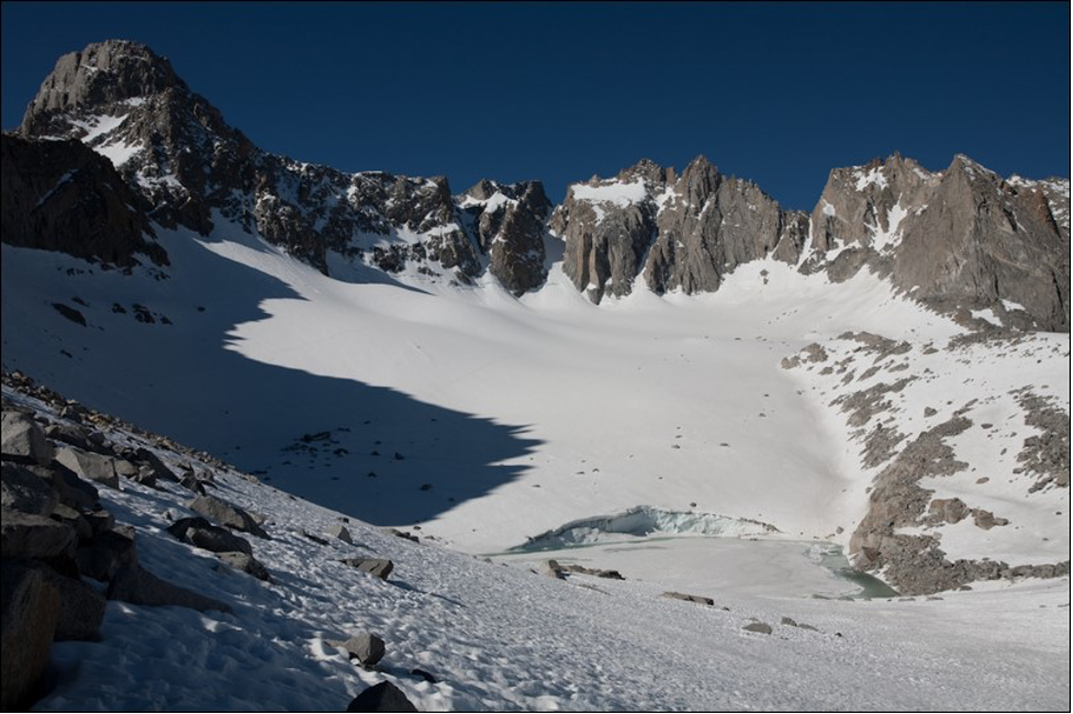
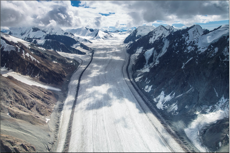
Mountain, alpine, or valley glaciers (Figure 19.2) typically develop in mountainous regions, often flowing out of icefields that span several peaks or even an entire mountain range. The largest mountain glaciers are found in Arctic Canada, Alaska, the Andes in South America, and the Himalaya in Asia.
Piedmont glaciers form where steep valley glaciers spill onto relatively flat plains and spread out into bulb-like lobes.
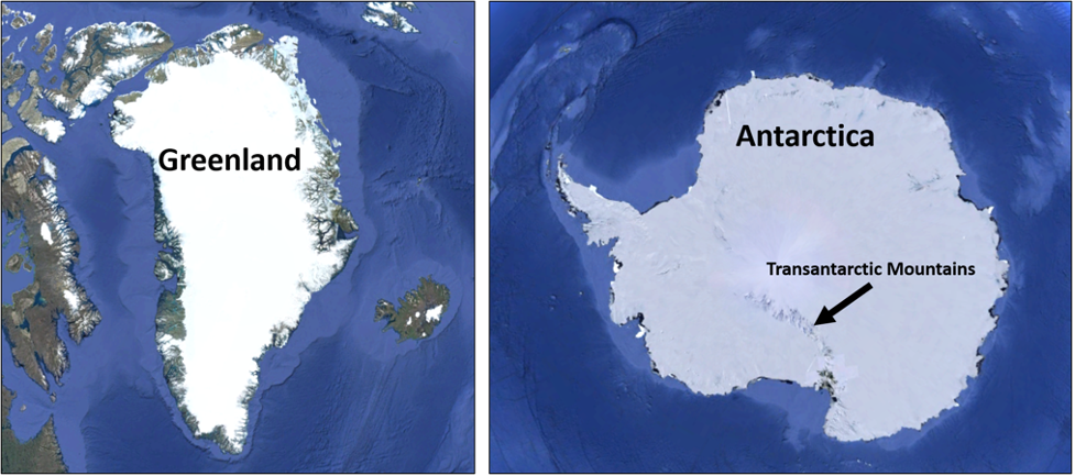
Ice sheets are enormous continental masses of glacial ice and snow expanding over 50,000 square kilometers (19,305 square miles). Currently, the only ice sheets are found in Antarctica and Greenland (Figure 19.3). Ice caps are miniature ice sheets, covering less than 50,000 square kilometers (19,305 square miles) and forming primarily in polar and subpolar regions.
Ice shelves occur when ice sheets extend over the sea and float on the water. They range from a few hundred meters to over 1 kilometer (0.62 mile) in thickness. Ice shelves surround most of the Antarctic continent. Sea ice is NOT a glacier, as glaciers develop only on land; however, much of the world's sea ice is enclosed within the polar regions.
How Does a Glacier Develop?
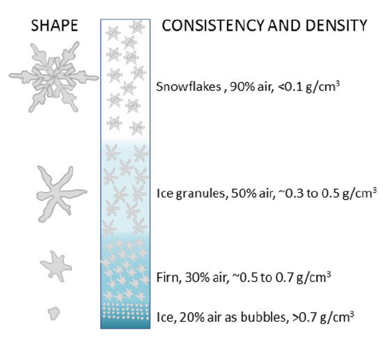
Glaciers require very specific climatic conditions to develop. Most form in polar latitudes or high-altitude regions, where accumulation of winter snow and ice is greater than its loss in the summer. As snow accumulates during winter, compression forces the older snow to recrystallize. After about a year, a denser, more compressed layer called firn develops (Figure 19.4). With enough pressure (from sequential burial) and time, firn will transform into crystalline glacial ice. True glacier ice takes hundreds of years to develop.
As the interconnecting air passages between the firn grains are sealed off, air bubbles will be formed. These air bubbles are important for exploring climate and the events of the geologic, or historic, past.

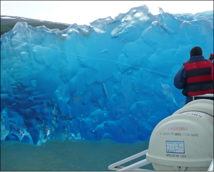
Why is Glacial Ice Blue? Ice only appears blue when it is sufficiently consolidated such that air bubbles cannot interfere with the passage of light. Without the scattering effect of air bubbles, light can penetrate ice undisturbed. In ice, the absorption of light at the red end (long wavelengths) of the spectrum is greater than at the blue end (short wavelengths). In general, the deeper light energy travels within a glacier, the more longwave colors are lost. About two meters into the glacier, most of the red colors are gone. The short wavelengths are left behind, which results in the distinct blue color we see (Figure 19.5).
How Do Glaciers Move?
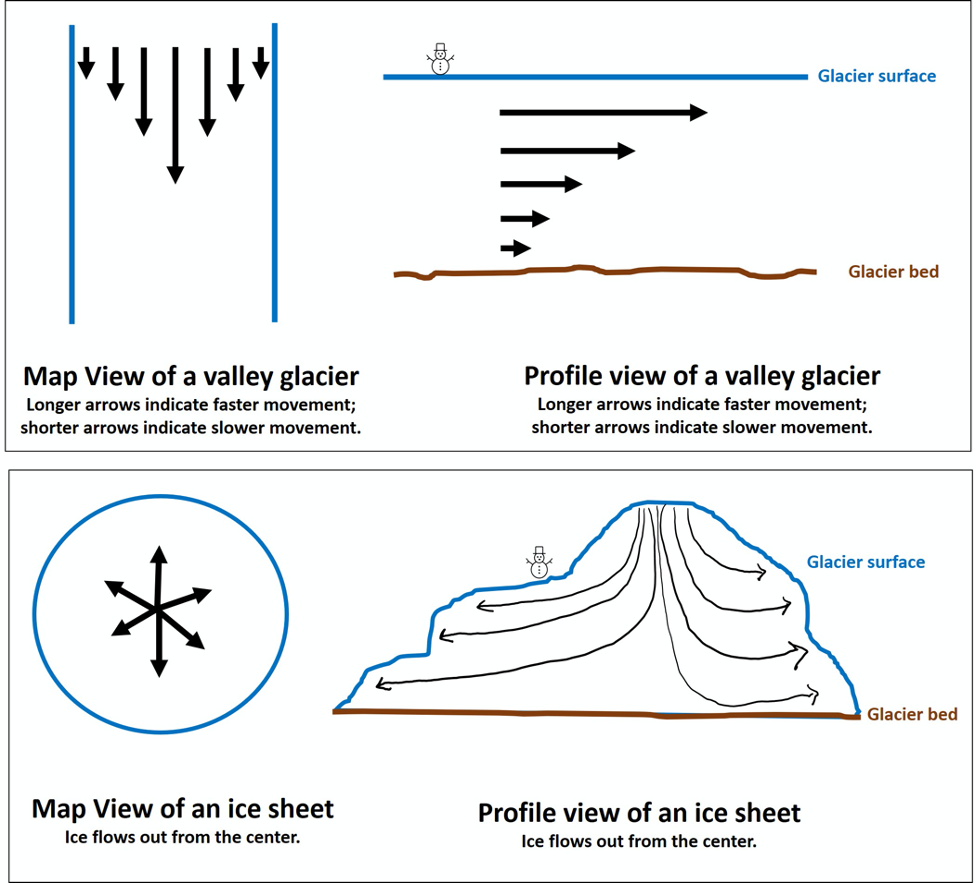
Glaciers flow outwards and downwards under the pressure of their own weight and the forces of gravity. Valley glaciers tend to flow down valleys, with the fastest flow rate in the upper central region of the glacier. Friction along the valley glaciers’ sides and base cause the flow rate to be much slower, whereas continental ice sheets flow outward in all directions (Figure 19.6).
Glacial movement happens mostly through internal deformation of the ice, and by sliding over the rocks and sediments at the glacier’s bed or base. Internal deformation occurs when the weight and mass of a glacier cause it to spread out due to gravity. Sliding primarily occurs due to the presence of meltwater at the bed; more meltwater reduces friction at the base and increases the likelihood of movement. In some glaciers, an excess of meltwater can induce glacial surge events, where a glacier will advance quickly during a short period of time (up to 100x the normal movement). During rapid uneven movement, some glaciers will develop cracks or crevasses.
What Is Glacial Advance and Retreat?
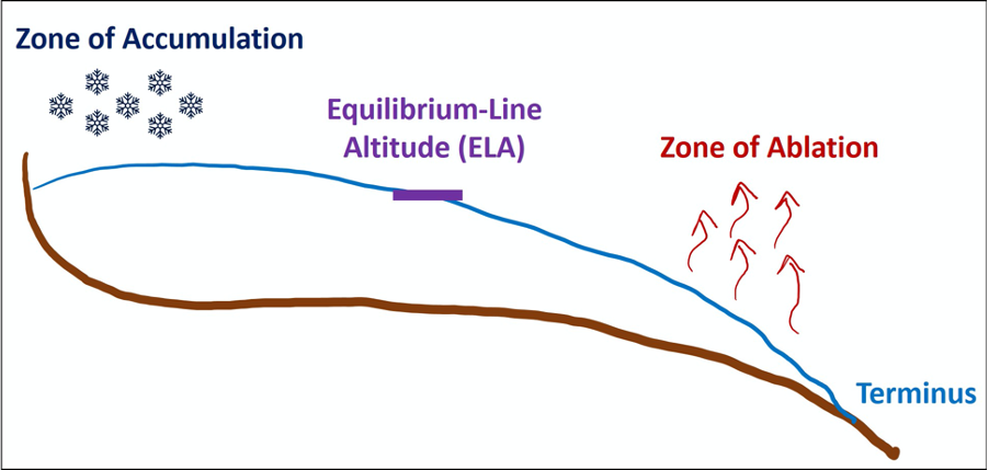
Glacial advance and retreat are dictated by the amount of material entering the zone of accumulation and exiting the zone of ablation. The glacier will advance (i.e. extend its terminus down the length of the valley) when accumulation exceeds ablation. For this to occur, more snow and ice must fall and accumulate than is melted or evaporated away. The glacier will recede (i.e. the terminus retreats up the length of the valley) when ablation exceeds accumulation. More snow and ice is melted or evaporated from the zone of ablation than is added to the accumulation zone. (Figure 19.7). It is important to remember that even in retreat, glaciers are always moving forward. You can liken their movement to the conveyor belts we put our groceries on at the store.
Over the last century, we have witnessed many glaciers retreating worldwide. This has become an important marker for global climate change. Here in the US, many of our National Parks contain glaciers which are heavily monitored, including at Yosemite National Park here in California, but also Glacier National Park in Montana and the many National Parks and glaciated areas in Alaska.
What Are Milankovitch Cycles?
Over a century ago, Serbian scientist Milutin Milankovitch hypothesized the long-term, collective effects of changes in Earth’s position relative to the Sun were a strong driver of Earth’s long-term climate and responsible for triggering the beginning and end of glacial periods (Ice Ages). Milankovitch determined that over time, Earth’s movement in space affects the amount of radiation received from the sun. Collectively, his ideas are known as the Milankovitch Cycles and include the following patterns of motion.
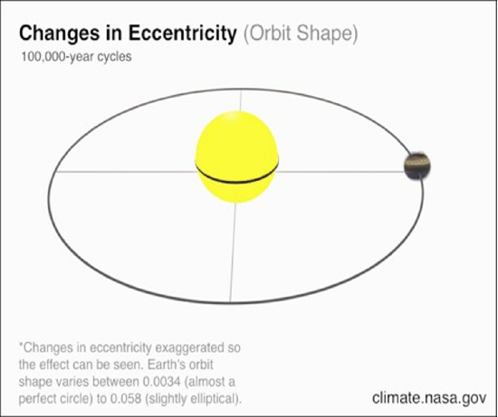
Eccentricity, the overall shape of Earth’s orbit around the Sun, alternates between more circular and more elliptical in a cycle that spans about 100,000 years, in part due to the gravitational influence of the gas giants, Jupiter and Saturn. Currently, Earth’s eccentricity is near its least elliptic (i.e. most circular) and is very slowly decreasing (Figure 19.9). For GIFS visit this NASA page.
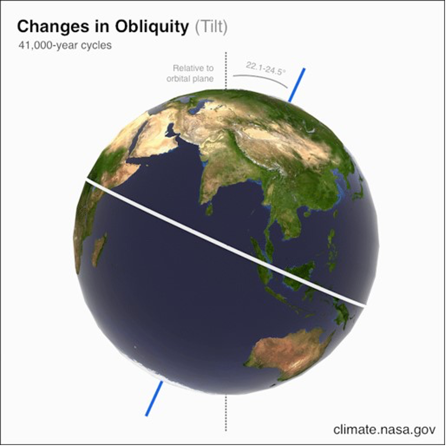
Obliquity is the angle of Earth’s axis of rotation relative to its ecliptic plane around the Sun. Obliquity is the reason Earth has seasons and is a very strong control on Earth’s climate and glacial periods. Typically, Earth’s obliquity varies between 22.1 and 24.5 degrees in a cycle that spans about 41,000 years, with minimum tilt favoring glaciation and maximum tilt promoting interglacial periods. Earth’s axis is currently tilted 23.4 degrees and is very slowly decreasing towards minimum tilt (Figure 19.10). For GIFS visit this NASA page.
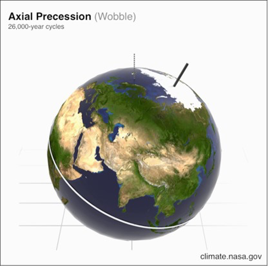
Precession is the slight wobble of Earth as it rotates on its axis. This wobble is due to tidal forces caused by the gravitational influences of the Sun and Moon. The direction of wobble is determined relative to the fixed positions of stars; Earth is currently fixed to Polaris in the northern hemisphere but may wobble toward other North Stars, including Thuban and Kochab. The cycle of axial precession spans about 25,000 years (Figure 19.11). For GIFS visit this NASA page.
When the cycles occur together at the same interval, they can influence Earth’s climate, and with other factors in place may encourage a glacial period or glaciation to occur.
What Is a Glacial Period?
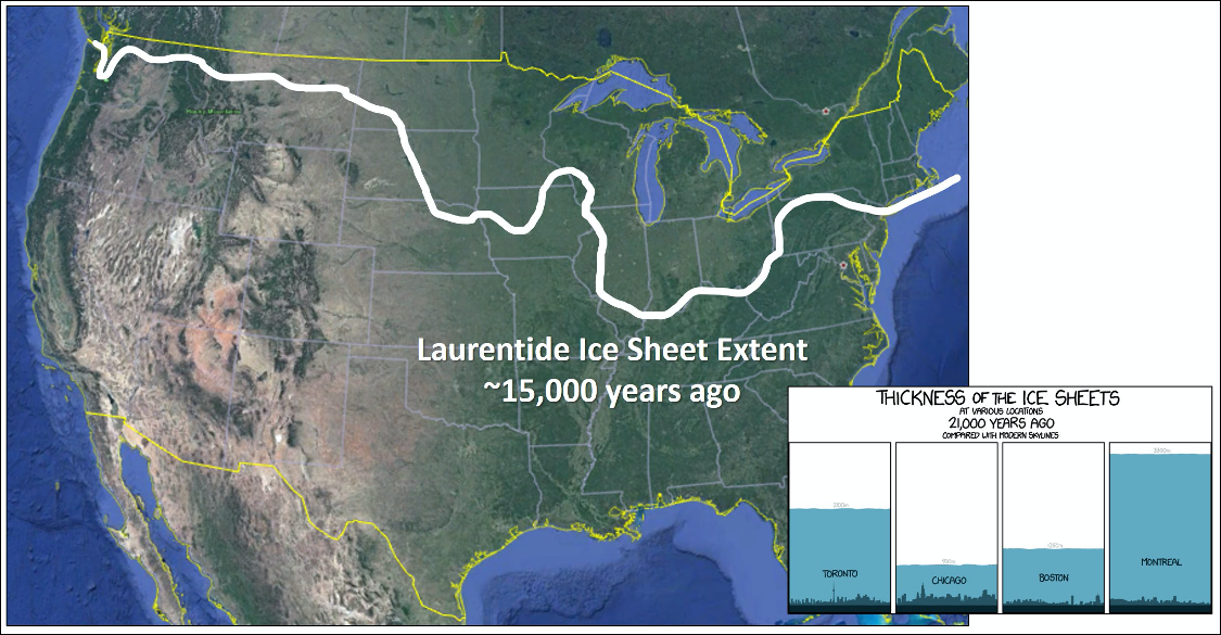
A glaciation is the modification of the land surface by the action of glaciers. Typically, the dominant glacier will be an ice sheet, but valley glaciers will also advance during this time. At the peak of the Last Glacial Maximum (~21,000 years ago), the Laurentide Ice Sheet covered most of northern North America and extended as far south as Nebraska and Illinois. During this time, major cities like Chicago, New York City, and Boston were buried beneath one to two miles of ice (Figure 19.12). The ice sheet essentially bulldozed the North American continent and left behind a distinct landscape and landforms. During this time, the valley glaciers in the Sierras and Rockies also grew and heavily altered their landscape.
How Are Glacial Sediments Unique?
As glaciers flow, they plow up or push aside rock and debris, which is then left behind when the glacier recedes. As large glaciers retreat, the underlying ground surface is typically abraded of most materials, leaving scars and debris on the underlying bedrock surface. Glacial ice is responsible for a large amount of erosion, and a lot of sediment can be carried on top of (supraglacial), within (englacial), and beneath (subglacial) ice. When sediment is left behind by a melting glacier, it is called glacial till (Figure 19.13).
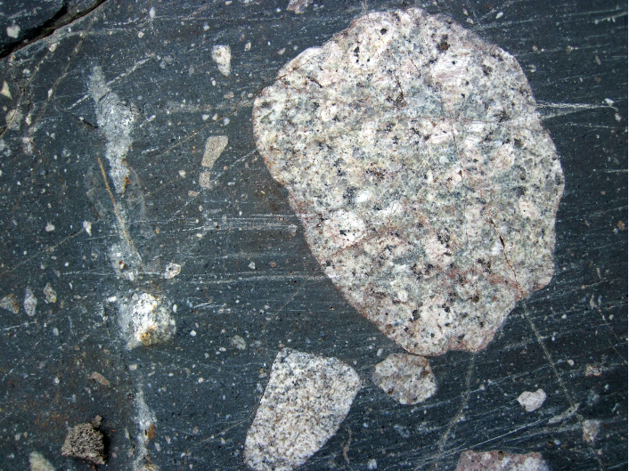
Till is generally poorly sorted, angular to subrounded, with grain sizes ranging from clay and silt to pebbles and boulders. The lithified rock is referred to as tillite or, more generally, a diamictite; both signify a rock that includes a wide range of clast sizes (Figure 19.14).
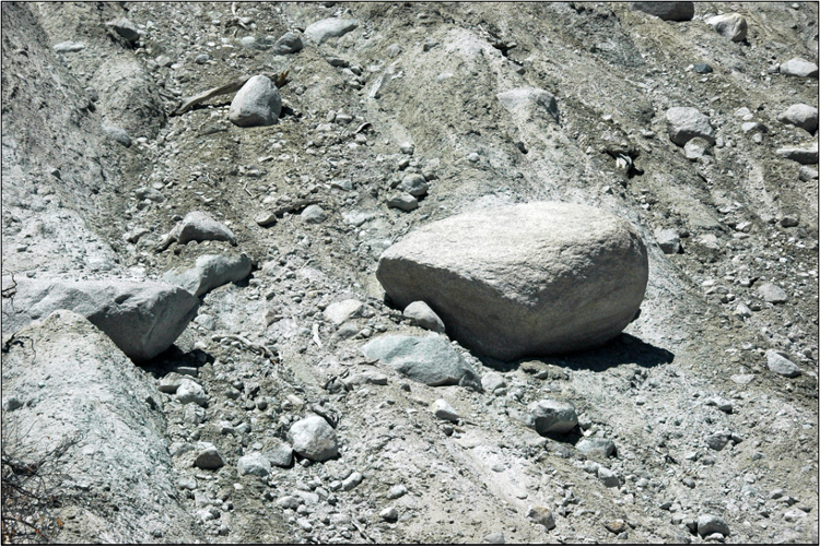
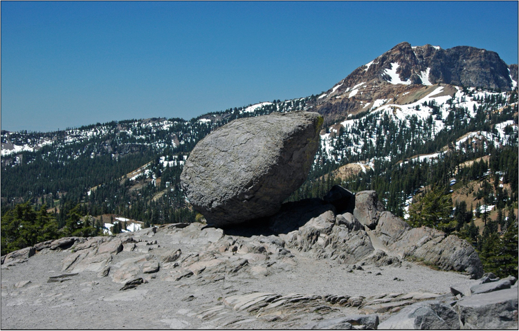
When glaciers retreat, they may leave behind large boulders of rock types that do not match the local bedrock, called glacial erratics (Figure 19.15). Really small clay-sized sediment frequently forms glacial or rock flour, which can cause glacial lakes and water bodies to have a milky appearance.
Often, the sediment carried within the ice affects the underlying bedrock, or even other sediment carried by the glacier. Glacial striations, scratches, or grooves can be carved into the bedrock, or on the cobbles and boulders carried by the ice (Figure 19.16).
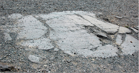
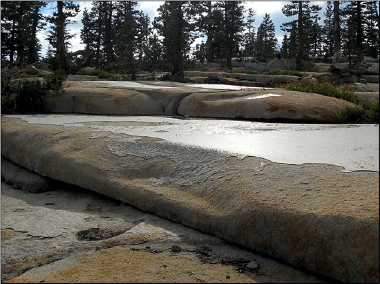
Additionally, glacial polish, produced by fine-sediment carried by the glacier, creates an almost mirror-like finish to the bedrock (Figure 19.17).
Glacial Depositional Landforms
A moraine is an accumulation of glacial till derived by the grinding and erosive effects of a glacier. In valley glaciers, moraines can be produced by material falling on the sides of the glacier via landslides from the valley walls. Overall, glaciers act like conveyor belts, always flowing downslope, carrying sediments inside and on the ice and depositing them at the end of their flow and along their sides. There are few varieties of moraine that are categorized by deposition location and glacial type.
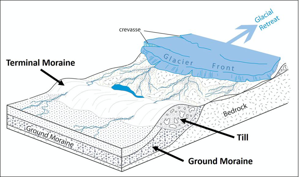
A terminal moraine is a ridge of unsorted till at the terminus, or farthest extent, of a glacier (Figure 19.18). As glaciers retreat, they typically leave behind deposits called recessional moraines, which are similar to terminal moraines but instead form when glacier retreat pauses. Behind the terminal and recessional moraines is a thin sheet of till on top of bedrock called the ground moraine. (Figure 19.18).
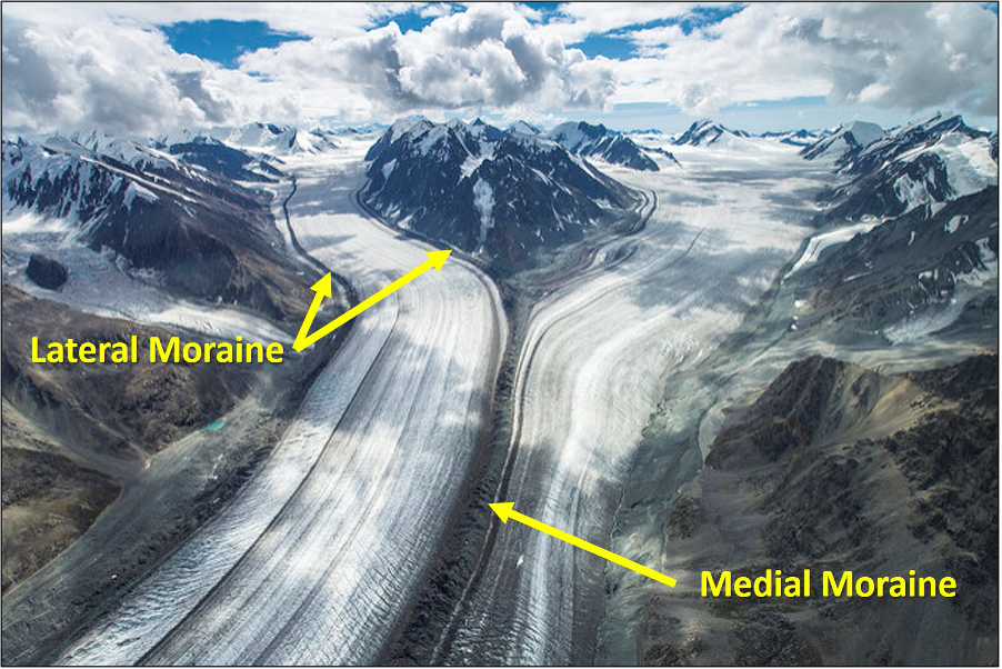
In valley glaciers, moraines located along the side of a glacier are called lateral moraines and mostly represent material that fell via landslides onto the sides of the glacier from the valley walls. When two tributary glaciers join, the two lateral moraines merge and combine to form a medial moraine. (Figure 19.19).
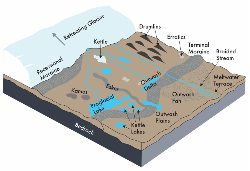
Other depositional landforms can be produced by meltwater streams as they carry sediment from the melting glacier. This sediment is deposited at the terminus of the glacier in an area called the outwash plain. These areas, particularly those at the terminus of continental glaciers, contain an abundance of additional landforms (Figure 19.20). For example, large blocks of ice can be left behind on the plain to melt creating a depression called a kettle that can be later filled with surface water like a kettle lake.
As glaciers melt, the meltwater flows over the ice surface until it descends into crevasses, finding channels within the ice or continuing to the base of the glacier into channels along the bottom. Such streams located under continental glaciers carry sediment in a sinuous channel within or under the ice, like a river. When the ice recedes, the sediment remains as a long sinuous ridge known as an esker (Figure 19.20).
Meltwater descending through the ice or along the margins of the ice may deposit mounds of sediment that remain as hills called kames (Figure 19.20). The meltwater that forms eskers and kames results in these landforms being composed of sediment (stratified drift), which is layered, sorted, and more rounded than till.
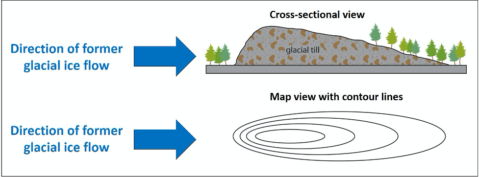
Other landforms typical of the outwash plain include drumlins, elongated teardrop-shaped hills. Drumlins form with their steepest side pointing upstream to the flow of ice and streamlined side (low angle side) pointing in the direction the ice is flowing (Figure 19.21). Vast quantities of drumlins occur in drumlin fields, common in the US in places like New York, Wisconsin and Minnesota. The origin of drumlins is still unknown; however, leading ideas suggest incremental accumulation of till under the glacier, large catastrophic meltwater floods beneath the glacier, or surface deformation by the weight of the overlying glacial ice.
Glacial Erosional Landforms
The sediment carried glacial ice and subglacial runoff is responsible for the majority of the erosion of glacial environments. As we saw above, the sediment grinds, carves, and polishes the bedrock surface.
Continental glaciers act as bulldozers, and as a result produce uniformly subdued topography. Valley glaciers, on the other hand, are confined by their topography and typically produce distinct erosional features, visible once the glacier recedes (Figure 19.22): for example, glacial troughs or U-shaped valleys, and, in coastally glaciated areas, fjords (submerged glacial valleys). Between two adjacent U-shaped valleys you will typically find a ridge called an arête. At the head of a valley glacier there is often a cirque, a bowl-shaped feature where the head of the glacier is eroding against the mountain by plucking rock away.
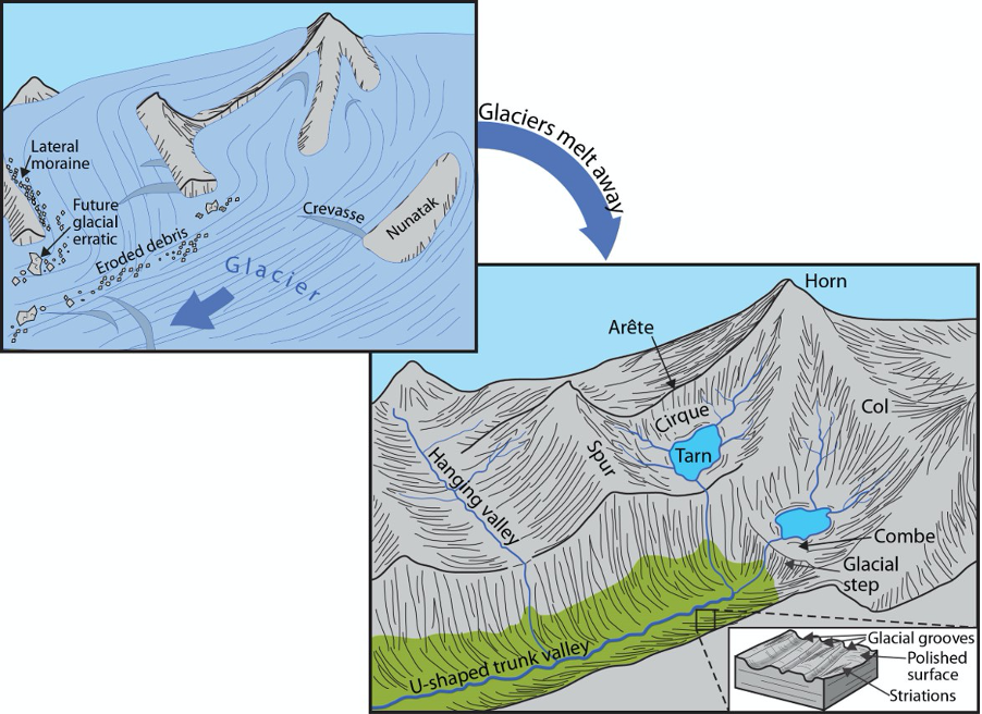
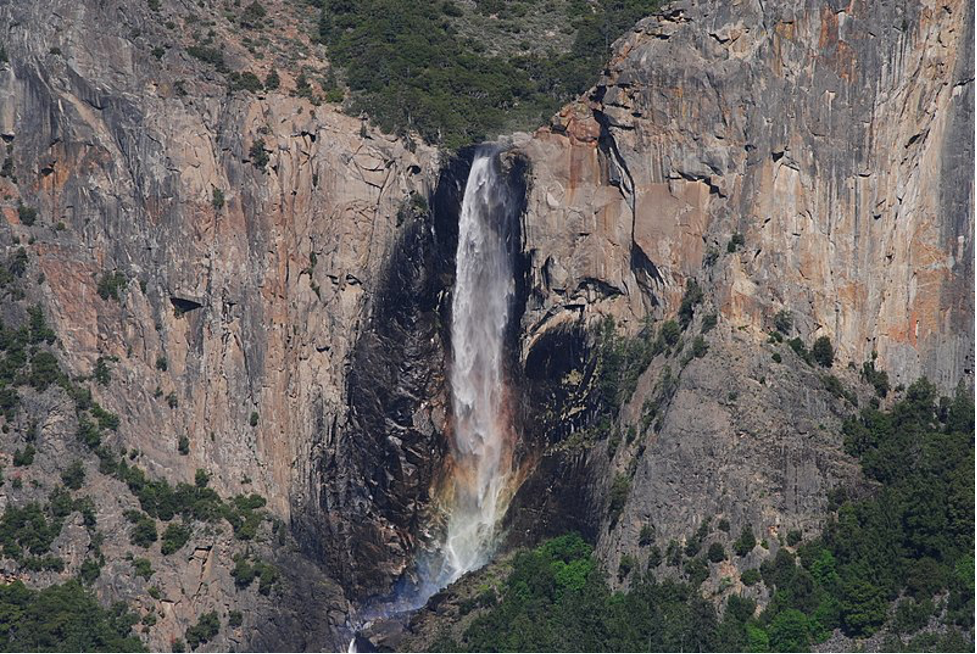
After the glacier is gone, the bowl at the bottom of the cirque can be occupied by a tarn lake. Headward cirque erosion by three or more mountain glaciers produces glacial horns, steep-sided, pyramid-shaped mountains. Low points along arêtes or between horns are termed cols, or mountain passes. Smaller tributary glaciers can intersect larger glaciers, and, after the ice recedes, the tributary valley becomes a hanging valley, sometimes with a waterfall, like Bridalveil Falls in Yosemite National Park (Figure 19.23).
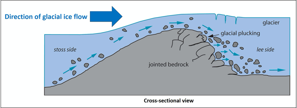
Lastly, roche moutonnée (or sheepback) are bedrock formations that are produced when the glacial ice abrades and plucks the underlying bedrock into an asymmetric form (Figure 19.24).
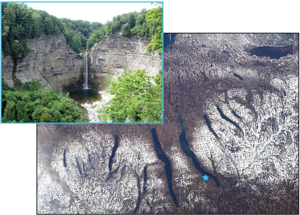
Lakes are common features in glacial environments. In addition to the tarn lakes of valley glaciers, there may be a series of lakes, called paternoster lakes, which can develop when recessional moraines isolate multiple basins within a glaciated valley. Common in both valley and continental glaciated areas, elongated lakes may occupy glacially carved depressions, known as finger lakes, the most famous being the aptly named Finger Lakes of central New York (Figure 19.25). In areas of continental glaciation, the crust is depressed isostatically by crustal loading from the weight of thick glacial ice. Basins are formed along the edges these continental glaciers will fill with meltwater and form proglacial lakes (Figure 19.20). These glacial lakes often have unique sediment deposition, including glacial varves, which represent seasonal sediment accumulation.
Attributions
- Figure 19.1: “Palisade Glacier and Mount Sill” (CC-BY-SA 2.0; Dave Ciskowski via Flickr)
- Figure 19.2: “Types of Glaciers: Valley Glacier, Fraser Glacier” (Public Domain; Jacob W. Frank/NPS Photo via Flickr)
- Figure 19.3: “Ice Sheets” (CC-BY 4.0; Chloe Branciforte via Google Earth, own work)
- Figure 19.4: “Glacial Ice Development” (CC-BY 4.0; Steven Earle via OpenText)
- Figure 19.5: “Blue Glacial Ice” (CC-BY 2.0; James St. John via Flickr)
- Figure 19.6: “Glacial Movement” (CC-BY 4.0; Chloe Branciforte, own work)
- Figure 19.7: “Zone of Accumulation and Ablation” (CC-BY 4.0; Chloe Branciforte, own work)
- Figure 19.8: “Glacier” (CC-BY-NC 2.5; xkcd via xkcd.com)
- Figure 19.9: “Milankovitch (Orbital) Cycles and Their Role in Climate” (Public Domain; NASA)
- Figure 19.10: “Milankovitch (Orbital) Cycles and Their Role in Climate” (Public Domain; NASA)
- Figure 19.11: “Milankovitch (Orbital) Cycles and Their Role in Climate” (Public Domain; NASA)
- Figure 19.12: Derivative of “Glacier” (CC-BY-NC 2.5; xkcd via xkcd.com) by Chloe Branciforte
- Figure 19.13: “Alpine Glacial Till” (CC-BY 2.0; James St. John via Flickr)
- Figure 19.14: “Glacially Smoothed & Striated Tillite” (CC-BY 2.0; James St. John via Flickr)
- Figure 19.15: “Pleistocene Glacial Erratic” (CC-BY 2.0; James St. John via Flickr)
- Figure 19.16: “Glacial Striations on Lava” (CC-BY 2.0; James St. John via Flickr)
- Figure 19.17: “Glacial Polish Emigrant” (CC-BY-SA 4.0; Smack via Wikipedia)
- Figure 19.18: Derivative of “Glacial Features” (Public Domain; Trista L. Thornberry-Ehrlich, Colorado State University/NPS via Flickr) by Chloe Branciforte
- Figure 19.19: Derivative of “Baldwin and Fraser Glaciers Confluence” (Public Domain; Jacob W. Frank/NPS via Flickr) by Chloe Branciforte
- Figure 19.20: “Continental Ice Sheet Landforms” (CC-BY 4.0; Emily Haddad, own work)
- Figure 19.21: Derivative of “Drumlin & Roche Moutonnée” (Public Domain; Trista L. Thornberry-Ehrlich, Colorado State University/NPS via Flickr) by Chloe Branciforte
- Figure 19.22: “All Things Glacial” (Public Domain; Trista L. Thornberry-Ehrlich, Colorado State University/NPS via Flickr) by Chloe Branciforte
- Figure 19.23: "Bridalveil Falls, Yosemite" (CC-BY 3.0; Asamudra via Wikimedia Commons)
- Figure 19.24: Derivative of “Drumlin & Roche Moutonnée” (Public Domain; Trista L. Thornberry-Ehrlich, Colorado State University/NPS via Flickr) by Chloe Branciforte
- Figure 19.25: Derivative of "New York's Finger Lakes" (Public Domain; NASA) by Emily Haddad