
16.5: Activity 16D- Murky Mists Mountain Geologic Map and Cross-section
- Page ID
- 14860

\( \newcommand{\vecs}[1]{\overset { \scriptstyle \rightharpoonup} {\mathbf{#1}} } \) \( \newcommand{\vecd}[1]{\overset{-\!-\!\rightharpoonup}{\vphantom{a}\smash {#1}}} \)\(\newcommand{\id}{\mathrm{id}}\) \( \newcommand{\Span}{\mathrm{span}}\) \( \newcommand{\kernel}{\mathrm{null}\,}\) \( \newcommand{\range}{\mathrm{range}\,}\) \( \newcommand{\RealPart}{\mathrm{Re}}\) \( \newcommand{\ImaginaryPart}{\mathrm{Im}}\) \( \newcommand{\Argument}{\mathrm{Arg}}\) \( \newcommand{\norm}[1]{\| #1 \|}\) \( \newcommand{\inner}[2]{\langle #1, #2 \rangle}\) \( \newcommand{\Span}{\mathrm{span}}\) \(\newcommand{\id}{\mathrm{id}}\) \( \newcommand{\Span}{\mathrm{span}}\) \( \newcommand{\kernel}{\mathrm{null}\,}\) \( \newcommand{\range}{\mathrm{range}\,}\) \( \newcommand{\RealPart}{\mathrm{Re}}\) \( \newcommand{\ImaginaryPart}{\mathrm{Im}}\) \( \newcommand{\Argument}{\mathrm{Arg}}\) \( \newcommand{\norm}[1]{\| #1 \|}\) \( \newcommand{\inner}[2]{\langle #1, #2 \rangle}\) \( \newcommand{\Span}{\mathrm{span}}\)\(\newcommand{\AA}{\unicode[.8,0]{x212B}}\)
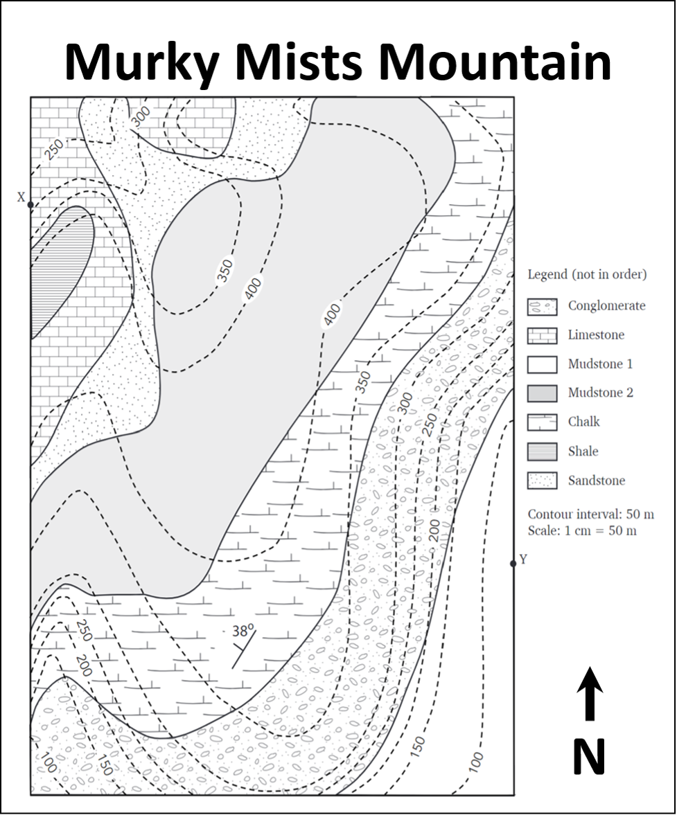
- Examine the map of the Murky Mists Mountain. Refer to the map legend. What kind of rocks are found in this map area (circle all that apply),
- Sedimentary
- Igneous
- Metamorphic
- How many units can you see?
- Note the strike and dip symbol on the map. Presume that the units all have identical strike and dip. Which direction are the units striking and dipping?
- Examine the contour lines on the map (dashed lines).
- Where are the highest points on the map?
- Where are the lowest points on the map?
- Note the scale of the map. What is the distance in meters between point X and point Y?
- If you walk from X to Y, in what direction are you walking?
- Prepare a cross-section through the map from position X to Y (X-Y) using the cross-section template we have provided. Do not forget to indicate the X and Y positions on your cross-section. Also, add a scale bar and the ratio scale, legend, and a title. Remember to add these critical components of a cross-section, legend, orientation, title, scale. Note: ensure your vertical scale and horizontal scale are the same, and order the units in your legend with the oldest at the bottom and the youngest at the top.
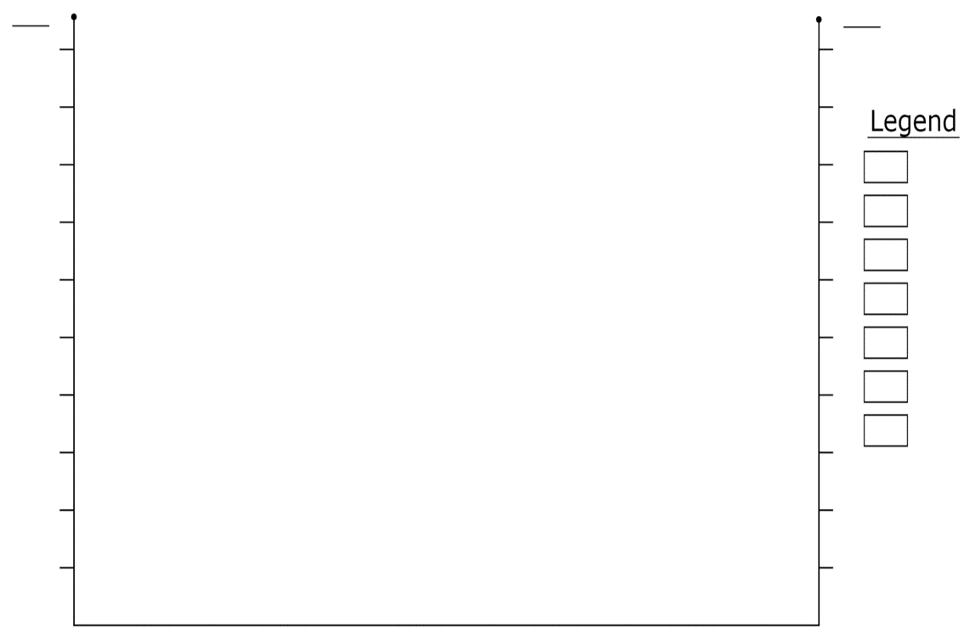
8. Using the cross-section you have prepared and the distances between the upper and lower contacts for each unit, calculate the thickness of the following units. Mark the location where you measured your thicknesses with a line on your cross-section. Note: the thickness is the shortest distance between the upper and lower contact of a bed: a line that runs perpendicular to both contacts.
a. Limestone:
b. Sandstone:
c. Mudstone 2:
d. Chalk:
e. Conglomerate:
9. Why can’t you measure the thickness of the shale or mudstone 1 units?
10. Describe the geological history of the map area, a bulleted list is OK to use here. Hint: start with the oldest event and describe events as they occurred up to the present day.