
9.9: Types of Volcano Hazards
- Page ID
- 2543
Volcanic eruptions are one of Earth’s most dramatic and violent agents of change. Not only can powerful explosive eruptions drastically alter land and water for tens of kilometers around a volcano, but tiny liquid droplets of sulfuric acid erupted into the stratosphere can change our planet’s climate temporarily. Eruptions often force people living near volcanoes to abandon their land and homes, sometimes forever. Those living farther away are likely to avoid complete destruction, but their cities and towns, crops, industrial plants, transportation systems, and electrical grids can still be damaged by tephra, ash, lahars, and flooding.
Fortunately, volcanoes exhibit precursory unrest that if detected and analyzed in time allows eruptions to be anticipated and communities at risk to be forewarned with reliable information in sufficient time to implement response plans and mitigation measures.
VOLCANIC GASES AND THEIR EFFECTS
Magma contains dissolved gases that are released into the atmosphere during eruptions. Gases are also released from magma that either remains below ground (for example, as an intrusion) or is rising toward the surface. In such cases, gases may escape continuously into the atmosphere from the soil, volcanic vents, fumaroles, and hydrothermal systems.
At high pressures deep beneath the earth’s surface, volcanic gases are dissolved in molten rock. But as magma rises toward the surface where the pressure is lower, gases held in the melt begin to form tiny bubbles. The increasing volume taken up by gas bubbles makes the magma less dense than the surrounding rock, which may allow the magma to continue its upward journey. Closer to the surface, the bubbles increase in number and size so that the gas volume may exceed the melt volume in the magma, creating a magma foam. The rapidly expanding gas bubbles of the foam can lead to explosive eruptions in which the melt is fragmented into pieces of volcanic rock, known as tephra. If the molten rock is not fragmented by explosive activity, a lava flow will be generated.
Together with the tephra and entrained air, volcanic gases can rise tens of kilometers into Earth’s atmosphere during large explosive eruptions. Once airborne, the prevailing winds may blow the eruption cloud hundreds to thousands of kilometers from a volcano. The gases spread from an erupting vent primarily as acid aerosols (tiny acid droplets), compounds attached to tephra particles, and microscopic salt particles.
Volcanic gases undergo a tremendous increase in volume when magma rises to the Earth’s surface and erupts. For example, consider what happens if one cubic meter of 900°C rhyolite magma containing five percent by weight of dissolved water were suddenly brought from depth to the surface. The one cubic meter of magma now would occupy a volume of 670 m3 as a mixture of water vapor and magma at atmospheric pressure (Sparks et. al., 1997)! The one meter cube at depth would increase to 8.75 m on each side at the surface. Such enormous expansion of volcanic gases, primarily water, is the main driving force of explosive eruptions.
The most abundant gas typically released into the atmosphere from volcanic systems is water vapor (H2O), followed by carbon dioxide (CO2) and sulfur dioxide (SO2). Volcanoes also release smaller amounts of others gases, including hydrogen sulfide (H2S), hydrogen (H2), carbon monoxide (CO), hydrogen chloride (HCL), hydrogen fluoride (HF), and helium (He).
| Examples of volcanic gas compositions, in volume percent concentrations (from Symonds et. al., 1994) | |||
|---|---|---|---|
| Volcano Tectonic Style Temperature | Kilauea Summit Hot Spot 1170°C | Erta` Ale Divergent Plate 1130°C | Momotombo Convergent Plate 820°C |
| H20 | 37.1 | 77.2 | 97.1 |
| C02 | 48.9 | 11.3 | 1.44 |
| S02 | 11.8 | 8.34 | 0.50 |
| H2 | 0.49 | 1.39 | 0.70 |
| CO | 1.51 | 0.44 | 0.01 |
| H2S | 0.04 | 0.68 | 0.23 |
| HCl | 0.08 | 0.42 | 2.89 |
| HF | — | — | 0.26 |
The volcanic gases that pose the greatest potential hazard to people, animals, agriculture, and property are sulfur dioxide, carbon dioxide, and hydrogen fluoride. Locally, sulfur dioxide gas can lead to acid rain and air pollution downwind from a volcano. Globally, large explosive eruptions that inject a tremendous volume of sulfur aerosols into the stratosphere can lead to lower surface temperatures and promote depletion of the Earth’s ozone layer. Because carbon dioxide gas is heavier than air, the gas may flow into in low-lying areas and collect in the soil. The concentration of carbon dioxide gas in these areas can be lethal to people, animals, and vegetation. A few historic eruptions have released sufficient fluorine-compounds to deform or kill animals that grazed on vegetation coated with volcanic ash; fluorine compounds tend to become concentrated on fine-grained ash particles, which can be ingested by animals.
Sulfur Dioxide (SO2)
The effects of SO2 on people and the environment vary widely depending on (1) the amount of gas a volcano emits into the atmosphere; (2) whether the gas is injected into the troposphere or stratosphere; and (3) the regional or global wind and weather pattern that disperses the gas. Sulfur dioxide (SO2) is a colorless gas with a pungent odor that irritates skin and the tissues and mucous membranes of the eyes, nose, and throat. Sulfur dioxide chiefly affects upper respiratory tract and bronchi. The World Health Organization recommends a concentration of no greater than 0.5 ppm over 24 hours for maximum exposure. A concentration of 6-12 ppm can cause immediate irritation of the nose and throat; 20 ppm can cause eye irritation; 10,000 ppm will irritate moist skin within minutes.
Emission rates of SO2 from an active volcano range from <20 tonnes/day to >10 million tonnes/day according to the style of volcanic activity and type and volume of magma involved. For example, the large explosive eruption of Mount Pinatubo on 15 June 1991 expelled 3-5 km3 of dacite magma and injected about 20 million metric tons of SO2 into the stratosphere. The sulfur aerosols resulted in a 0.5-0.6°C cooling of the Earth’s surface in the Northern Hemisphere. The sulfate aerosols also accelerated chemical reactions that, together with the increased stratospheric chlorine levels from human-made chlorofluorocarbon (CFC) pollution, destroyed ozone and led to some of the lowest ozone levels ever observed in the atmosphere.
At Kilauea Volcano, the recent effusive eruption of about 0.0005 km3/day (500,000 m3) of basalt magma releases about 2,000 tonnes of SO2 into the lower troposphere. Downwind from the vent, acid rain and air pollution is a persistent health problem when the volcano is erupting.
- SO2 causes air pollutionVolcanic smog. Eruptions of Kilauea Volcano release large quantities of sulfur dioxide gas into the atmosphere that can lead to volcanic air pollution on the Island of Hawai`i. Sulfur dioxide gas reacts chemically with sunlight, oxygen, dust particles, and water to form volcanic smog known as vog.
- SO2 effects Earth’s surface temperature Global cooling and ozone depletion. Measurements from recent eruptions such as Mount St. Helens, Washington (1980), El Chichon, Mexico (1982), and Mount Pinatubo, Philippines (1991), clearly show the importance of sulfur aerosols in modifying climate, warming the stratosphere, and cooling the troposphere. Research has also shown that the liquid drops of sulfuric acid promote the destruction of the Earth’s ozone layer.
Hydrogen Sulfide (H2S)
Hydrogen sulfide (H2S) is a colorless, flammable gas with a strong offensive odor. It is sometimes referred to as sewer gas. At low concentrations it can irritate the eyes and acts as a depressant; at high concentrations it can cause irritation of the upper respiratory tract and, during long exposure, pulmonary edema. A 30-minute exposure to 500 ppm results in headache, dizziness, excitement, staggering gait, and diarrhea, followed sometimes by bronchitis or bronchopneumonia.
Carbon Dioxide (CO2)
Volcanoes release more than 130 million tonnes of CO2 into the atmosphere every year. This colorless, odorless gas usually does not pose a direct hazard to life because it typically becomes diluted to low concentrations very quickly whether it is released continuously from the ground or during episodic eruptions. But in certain circumstances, CO2 may become concentrated at levels lethal to people and animals. Carbon dioxide gas is heavier than air and the gas can flow into in low-lying areas; breathing air with more than 30% CO2can quickly induce unconsciousness and cause death. In volcanic or other areas where CO2 emissions occur, it is important to avoid small depressions and low areas that might be CO2 traps. The boundary between air and lethal gas can be extremely sharp; even a single step upslope may be adequate to escape death.
CO2 trapped in depressions can be lethal to people and animals. When a burning piece of cloth is lowered into a hole that has a high concentration of CO2, the fire goes out. Such a condition can be lethal to people and animals.
Air with 5% CO2 causes perceptible increased respiration; 6-10% results in shortness of breath, headaches, dizziness, sweating, and general restlessness; 10-15% causes impaired coordination and abrupt muscle contractions; 20-30% causes loss of consciousness and convulsions; over 30% can cause death (Hathaway et. al., 1991).
Please see the web article, “Volcanic Gases and Climate Change Overview” for more information on Volcanic versus anthropogenic CO2emissions.
Here is a historical example of the effects of carbon dioxide gas: Mammoth Mountain in Long Valley Caldera, California kills trees near Mammoth Mountain, California
Hydrogen Chloride (HCL)
Chlorine gas is emitted from volcanoes in the form of hydrochloric acid (HCl). Exposure to the gas irritates mucous membranes of the eyes and respiratory tract. Concentrations over 35 ppm cause irritation of the throat after short exposure; >100 ppm results in pulmonary edema, and often laryngeal spasm. It also causes acid rain downwind from volcanoes because HCl is extremely soluble in condensing water droplets and it is a very “strong acid” (it dissociates extensively to give H+ ions in the droplets).
Hydrogen Fluoride (HF)
Fluorine is a pale yellow gas that attaches to fine ash particles, coats grass, and pollutes streams and lakes. Exposure to this powerful caustic irritant can cause conjunctivitis, skin irritation, bone degeneration and mottling of teeth. Excess fluorine results in a significant cause of death and injury in livestock during ash eruptions. Even in areas that receive just a millimeter of ash, poisoning can occur where the fluorine content of dried grass exceeds 250 ppm. Animals that eat grass coated with fluorine-tainted ash are poisoned. Small amounts of fluorine can be beneficial, but excess fluorine causes fluorosis, an affliction that eventually kills animals by destroying their bones. It also promotes acid rain effects downwind of volcanoes, like HCl.
Secondary Gas Emissions
Another type of gas release occurs when lava flows reach the ocean. Extreme heat from molten lava boils and vaporizes seawater, leading to a series of chemical reactions. The boiling and reactions produce a large white plume, locally known as lava haze or laze, containing a mixture of hydrochloric acid and concentrated seawater.
- Laze plumes are very acidic. Extreme heat from lava entering the sea rapidly boils and vaporizes seawater, leading to a series of chemical reactions. The boiling and reactions produce a large white plume, locally known as lava haze or laze, which contains a mixture of hydrochloric acid (HCl) and concentrated seawater. This is a short-lived local phenomenon that only affects people or vegetation directly under the plume.
The hydrochloric acid (HCl) comes from the breakdown of seawater-derived chlorides during sudden boiling. Because the lava is largely degassed by the time it reaches the sea, any HCL coming from it is insignificant by comparison. Analyzed samples of the plume show that is is a brine with a salinity of about 2.3 times that of seawater and a pH of 1.5-2.0. - Key seawater chloride breakdown reactions that produce HCl gas
- MgCl2 (sea salt) + H2O (steam) = MgO (periclase) + 2HCl (HCl gas)
- 2 NaCl (sea salt) + H2O (steam) = Na2O (sodium oxide) + 2 HCL (HCl gas)
- CaCl2 (sea salt) + H2O (steam) = CaO (lime) + 2 HCL (HCl gas)
- Avoid standing beneath a laze plume. Dense laze plumes, such as that shown here (Photograph by C.C. Heliker, February 10, 1994) contain as much as 10-15 parts per million of hydrochloric acid. These values drop off sharply as the plume moves away from the lava entry areas. During along-shore or on-shore winds, this plume produces acid rain that may fall on people and land along the coast. This rain (pH 1.5 to 2), often more acidic that lime juice or stomach acid, is very corrosive to the skin and clothing. Visitors to the lava entry areas should avoid standing directly in, under, or downwind of the laze plume.
LAHARS AND THEIR EFFECTS
Lahar is an Indonesian term that describes a hot or cold mixture of water and rock fragments flowing down the slopes of a volcano and (or) river valleys. When moving, a lahar looks like a mass of wet concrete that carries rock debris ranging in size from clay to boulders more than 10 m in diameter. Lahars vary in size and speed. Small lahars less than a few meters wide and several centimeters deep may flow a few meters per second. Large lahars hundreds of meters wide and tens of meters deep can flow several tens of meters per second–much too fast for people to outrun.
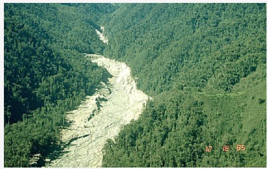
Figure 1. Gualí River valley. Photograph by R. Janda on December 18, 1985
As a lahar rushes downstream from a volcano, its size, speed, and the amount of water and rock debris it carries constantly change. The beginning surge of water and rock debris often erodes rocks and vegetation from the side of a volcano and along the river valley it enters. This initial flow can also incorporate water from melting snow and ice (if present) and the river it overruns. By eroding rock debris and incorporating additional water, lahars can easily grow to more than 10 times their initial size. But as a lahar moves farther away from a volcano, it will eventually begin to lose its heavy load of sediment and decrease in size.
Eruptions may trigger one or more lahars directly by quickly melting snow and ice on a volcano or ejecting water from a crater lake. More often, lahars are formed by intense rainfall during or after an eruption–rainwater can easily erode loose volcanic rock and soil on hillsides and in river valleys. Some of the largest lahars begin as landslides of saturated and hydrothermally altered rock on the flank of a volcano or adjacent hillslopes. Landslides are triggered by eruptions, earthquakes, precipitation, or the unceasing pull of gravity on the volcano.
Lahars almost always occur on or near stratovolcanoes because these volcanoes tend to erupt explosively and their tall, steep cones are either snow covered, topped with a crater lake, constructed of weakly consolidated rock debris that is easily eroded, or internally weakened by hot hydrothermal fluids. Lahars are also common from the snow- and ice-covered shield volcanoes in Iceland where eruptions of fluid basalt lava frequently occur beneath huge glaciers.
The scenarios listed below illustrate most of the mechanisms by which lahars are generated. For convenience, we’ve grouped the mechanisms according to whether a volcano is erupting, has erupted, or is quiet. Each mechanism is illustrated with one or more case studies.
VOLCANO LANDSLIDES AND THEIR EFFECTS
Landslides are large masses of rock and soil that fall, slide, or flow very rapidly under the force of gravity. These mixtures of debris move in a wet or dry state, or both. Landslides commonly originate as massive rockslides or avalanches which disintegrate during movement into fragments ranging in size from small particles to enormous blocks hundreds of meters across. If the moving rock debris is large enough and contains a large content of water and fine material (typically, >3-5 percent of clay-sized particles), the landslide may transform into a lahar and flow downvalley more than 100 km from a volcano!
Volcano landslides range in size from less than 1 km3 to more than 100 km3. The high velocity (>100 km/hr) and great momentum of landslides allows them to run up slopes and to cross valley divides up to several hundred meters high. For example, the landslide at Mount St. Helens on May 18, 1980, had a volume of 2.5 km3, reached speeds of 50-80 m/s (180-288 km/hr), and surged up and over a 400 m tall ridge located about 5 km from the volcano!
Landslides are common on volcanoes because their massive cones (1) typically rise hundreds to thousands of meters above the surrounding terrain; and (2) are often weakened by the very process that created them–the rise and eruption of molten rock. Each time magma moves toward the surface, overlying rocks are shouldered aside as the molten rock makes room for itself, often creating internal shear zones or oversteepening one or more sides of the cone. Magma that remains within the cone releases volcanic gases that partially dissolve in groundwater, resulting in a hot acidic hydrothermal system that weakens rock by altering rock minerals to clay. Furthermore, the tremendous mass of thousands of layers lava and loose fragmented rock debris can lead to internal faults and fault zones that move frequently as the cone “settles” under the downward pull of gravity.
These conditions permit a number of factors to trigger a landslide or to allow part of a volcano’s cone to simply collapse under the influence of gravity:
- intrusion of magma into a volcano
- explosive eruptions (magmatic or phreatic–steam-driven explosions)
- large earthquake directly beneath a volcano or nearby (typically >M5)
- intense rainfall that saturates a volcano or adjacent tephra-covered hillslopes with water, especially before or during a large earthquake.
A landslide typically destroys everything in its path and may generate a variety of related activity. Historically, landslides have caused explosive eruptions, buried river valleys with tens of meters of rock debris, generated lahars, triggered waves and tsunami, and created deep horseshoe-shaped craters.
By removing a large part of a volcano’s cone, a landslide may abruptly decrease pressure on the shallow magmatic and hydrothermal systems, which can generate explosions ranging from a small steam explosion to large steam- and magma-driven directed blasts. A large landslide often buries valleys with tens to hundreds of meters of rock debris, forming a chaotic landscape marked by dozens of small hills and closed depressions. If the deposit is thick enough, it may dam tributary streams to form lakes in the subsequent days to months; the lakes may eventually drain catastrophically and generate lahars and floods downstream.
Landslides also generate some of the largest and most deadly lahars, either by transforming directly into a lahar or, after it stops moving, from dewatering of the deposit. Historically, however, the most deadly volcano landslide occurred in 1792 when sliding debris from Mt. Mayuyama near Unzen Volcano in Japan slammed into the Ariaka Sea and generated a wave on the opposite side that killed nearly 15,000 people.
On a volcano, landslides typically carve deep gashes into its cone or create large horseshoe-shaped craters hundreds of meters deep and more than a kilometer in width.
Volcanic landslides can do the following:
- Trigger volcanic explosions
- Generate lahars that travel far downstream
- Cause waves and tsunamis in a lake or ocean
- Bury river valleys with rock debris
- Dam tributary streams to form lakes
- Create a crater or scar on the volcano
LAVA FLOWS AND THEIR EFFECTS
Lava flows are streams of molten rock that pour or ooze from an erupting vent. Lava is erupted during either nonexplosive activity or explosive lava fountains. Lava flows destroy everything in their path, but most move slowly enough that people can move out of the way. The speed at which lava moves across the ground depends on several factors, including (1) type of lava erupted and its viscosity; (2) steepness of the ground over which it travels; (3) whether the lava flows as a broad sheet, through a confined channel, or down a lava tube; and (4) rate of lava production at the vent.
Fluid basalt flows can extend tens of kilometers from an erupting vent. The leading edges of basalt flows can travel as fast as 10 km/hour on steep slopes but they typically advance less than 1 km/hour on gentle slopes. But when basalt lava flows are confined within a channel or lava tube on a steep slope, the main body of the flow can reach velocities >30 km/hour.
Viscous andesite flows move only a few kilometers per hour and rarely extend more than 8 km from their vents. Viscous dacite and rhyolite flows often form steep-sided mounds called lava domes over an erupting vent. Lava domes often grow by the extrusion of many individual flows >30 m thick over a period of several months or years. Such flows will overlap one another and typically move less than a few meters per hour.
Everything in the path of an advancing lava flow will be knocked over, surrounded, or buried by lava, or ignited by the extremely hot temperature of lava. When lava erupts beneath a glacier or flows over snow and ice, meltwater from the ice and snow can result in far-reaching lahars. If lava enters a body of water or water enters a lava tube, the water may boil violently and cause an explosive shower of molten spatter over a wide area. Methane gas, produced as lava buries vegetation, can migrate in subsurface voids and explode when heated. Thick viscous lava flows, especially those that build a dome, can collapse to form fast-moving pyroclastic flows.
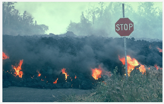
Figure 2. `A`a lava flow moves through an intersection in the Royal Garderns subdivision on the south flank of Kilauea Volcano, Hawai`i. Photograph by J.D. Griggs in 1984.
Deaths caused directly by lava flows are uncommon because most move slowly enough that people can move out the way easily and flows usually don’t travel far from the vent. Death and injury can result when onlookers approach an advancing lava flow too closely or their retreat is cut off by other flows. Deaths attributed to lava flows are often due to related causes, such as explosions when lava interacts with water, the collapse of an active lava delta, asphyxiation due to accompanying toxic gases, pyroclastic flows from a collapsing dome, and lahars from meltwater.
Other natural phenomena such as hurricanes, tornadoes, tsunami, fires, and earthquakes often destroy buildings, agricultural crops, and homes, but the owner(s) can usually rebuild or repair structures and their businesses in the same location. Lava flows, however, can bury homes and agricultural land under tens of meters of hardened black rock; landmarks and property lines become obscured by a vast, new hummocky landscape. People are rarely able to use land buried by lava flows or sell it for more than a small fraction of its previous worth.
Lava erupted from Kilauea Volcano covers part of Highway 130 on the southeast coast of the Island of Hawai`i (see figure 3). By the end of 1998, lava from the Pu’u’ ‘O’o-Kupaianaha eruption covered about 13 km of the highway to depths as great as 25 m. Between 1983 and 1998, lava flows covered an area of 99.7 km2 (38.5 mi2).
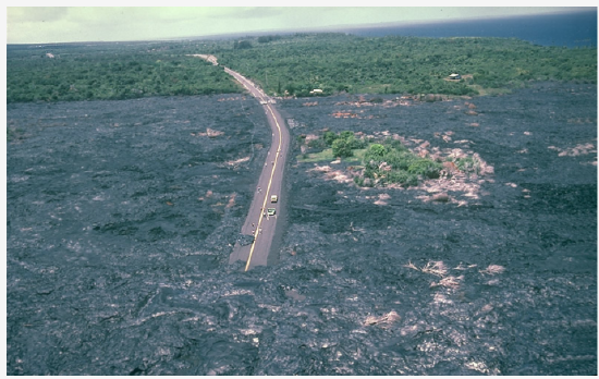
Figure 3. Lava buries or surrounds everything.
Because lava flows can completely block roads and highways that may serve as the only evacuation route for people threatened by an advancing flow, it is vital for communities that could be inundated with lava to develop emergency-response plans.
One of the chief threats of lava flows to property owners is that the flows may burn buildings and homes even if the flow doesn’t reach the structure. This house caught fire from the intense heat of an advancing `a`a flow (note red glow of flow left of the house).
Basalt has the highest temperature of any lava, typically between about 1170-1100°C (~2140-2000°F). The other lava types (andesite, dacite, and rhyolite) form cooler flows with temperatures between about 1000-800°C (~1800-1500°F); some flows can still move slowly at temperatures as low as about 600°C (~1100°F).
Lava melts snow and ice to form jökulhlaups and lahars. By this time, the area of subsidence had grown to about 9 km long and 2-3 km wide. The eruption continued for about another 10 days, and meltwater from the glacier flowed into the Grímsvötn caldera. On October 1, water level in the caldera’s subglacial lake was about 1410 m; by October 16, the water level had risen to 1504 m, an increase of 94 m! According to scientists monitoring the activity, lava erupting from the fissure was piled up on the ground beneath the glacier, “forming a mountain ridge which in places is expected to be 200 m high.”
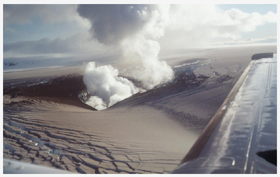
Figure 4. View of eruption crater and ash-covered Vatnajökull glacier about 36 hours after the eruption had broken through the ice. Photograph courtesy of Magnús Tumi Guðmundsson. Science Institute, University of Iceland. October 1, 1996, 12:30 p.m.
On October 16, scientists stated that the meltwater, which had been accumulating under the ice shelf in the Grímsvötn caldera lake, could begin draining at any time to trigger a jökulhlaup (glacial outburst flood). On November 5 the expected jökulhlaup began.
Collapsing lava flows trigger pyroclastic flows. The fast-moving pyroclastic flow was caused by the collapse of a thick lava flow that was extruding from the summit area and oozing down the volcano’s steep upper cone. When the lava flow collapsed, the hot lava broke apart into fragments ranging in size from boulders to tiny ash particles and swept down the volcano under the influence of gravity to form the pyroclastic flow; the flow reached a maximum distance of 4.5 km from the summit.
PYROCLASTIC FLOWS AND THEIR EFFECTS
About Pyroclastic Flows
Pyroclastic flows are high-density mixtures of hot, dry rock fragments and hot gases that move away from the vent that erupted them at high speeds. They may result from the explosive eruption of molten or solid rock fragments, or both. They may also result from the nonexplosive eruption of lava when parts of dome or a thick lava flow collapses down a steep slope. Most pyroclastic flows consist of two parts: a basal flow of coarse fragments that moves along the ground, and a turbulent cloud of ash that rises above the basal flow. Ash may fall from this cloud over a wide area downwind from the pyroclastic flow.
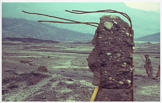
Figure 5. Pyroclastic Flows destroy by direct impact.
Figure 5 shows a remnant of a building in Francisco Leon that was destroyed by pyroclastic flows and surges during the eruption of El Chichon volcano in southeastern Mexico between March 29 and April 4, 1982. Francisco Leon was located about 5 km SSE of the volcano. The reinforcement rods in the concrete wall are bent in the direction of flow (right to left).
Several pyroclastic surges swept down all sides of the volcano, reaching as far as 2 to 8 km from the volcano; pyroclastic flows represent only about 30 percent of the total combined mass of surges and flows. In addition to Francisco Leon, eight other villages were destroyed, claiming the lives of up to 2,000 people.
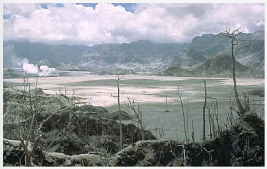
Figure 6. Pyroclastic Flows bury sites with hot rock debris.
Pyroclastic flows erupted by Mount Pinatubo on June 15, 1991, buried the Marella River valley (SW of Pinatubo) with pumice, ash, and other volcanic rocks to depths of between 50 and 200 m (as shown in figure 6). This eruption was one of the largest in the 20th century, depositing about 5.5 km3 of rock debris over nearly 400 km2. The pyroclastic flows traveled as far as 12 to 16 km from the volcano in all directions. Unlike river valleys, the steep slopes around the volcano were veneered with very thin, discontinuous pyroclastic-flow deposits.
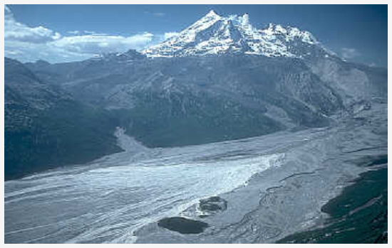
Figure 7. Pyroclastic Flows melt snow and ice to form lahars.
A series of pyroclastic flows from Redoubt Volcano in Alaska between December 1989 and April 1990 rapidly melted snow and ice that generated lahars in Drift River (valley in figure 7). The lahars swept 40 km to Cook Inlet. Most of the pyroclastic flows were caused by the repeated collapse of a lava dome growing high on the volcano’s north flank.
This view across the upper Drift River valley is to the SW; the north flank is on the right side of the volcano, but the dome is not visible. As each pyroclastic flow swept down the volcano’s snow- and glacier-covered north flank, the hot lava-dome fragments eroded and mixed with the snow and ice to form a torrent of water that swept into Drift River. The sudden surges of water eroded loose sediment on the valley floor and transformed into lahars.
In this part of the Drift River valley, many of the lahars covered the entire valley floor, but they were generally no more than a few meters thick. The lahars provided an excellent opportunity to test a new lahar detection system.
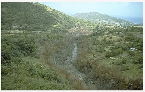
Figure 8. Pyroclastic Flows burn forests, crops, and buildings.
A small but highly fluidized pyroclastic flow traveled down the narrow Belham stream channel as far as 5 to 6 km from a lava dome growing at the summit of Soufriere Hills volcano in Montserrat (shown in figure 8). The basal part of the pyroclastic flow was confined to the channel bottom, but the overriding hot ash cloud burned and killed vegetation along the channel. The pyroclastic flow was triggered by a partial collapse of the dome. With initial temperatures higher than 900°C, the rock debris and gas carried by a pyroclastic flow or surge easily remain hot enough to burn or singe combustible material even when they travel more than 20 km from a vent.
Effects of Pyroclastic Flows
A pyroclastic flow will destroy nearly everything in its path. With rock fragments ranging in size from ash to boulders traveling across the ground at speeds typically greater than 80 km per hour, pyroclastic flows knock down, shatter, bury or carry away nearly all objects and structures in their way. The extreme temperatures of rocks and gas inside pyroclastic flows, generally between 200°C and 700°C, can cause combustible material to burn, especially petroleum products, wood, vegetation, and houses.
Pyroclastic flows vary considerably in size and speed, but even relatively small flows that move less than 5 km from a volcano can destroy buildings, forests, and farmland. And on the margins of pyroclastic flows, death and serious injury to people and animals may result from burns and inhalation of hot ash and gases.
Pyroclastic flows generally follow valleys or other low-lying areas and, depending on the volume of rock debris carried by the flow, they can deposit layers of loose rock fragments to depths ranging from less than one meter to more than 200 m. Such loose layers of ash and volcanic rock debris in valleys and on hillslopes can lead to lahars indirectly by:
- Damming or blocking tributary streams, which may cause water to form a lake behind the blockage, overtop and erode the blockage, and mix with the rock fragments as it rushes downstream (for example, see this case study at Pinatubo Volcano, Philippines)
- Increasing the rate of stream runoff and erosion during subsequent rainstorms. Hot pyroclastic flows and surges can also directly generate lahars by eroding and mixing with snow and ice on a volcano’s flanks, thereby sending a sudden torrent of water surging down adjacent valleys (see case study from Nevado del Ruiz volcano, Colombia).
TEPHRA AND THEIR EFFECTS
Tephra is a general term for fragments of volcanic rock and lava regardless of size that are blasted into the air by explosions or carried upward by hot gases in eruption columns or lava fountains. Such fragments range in size from less than 2 mm (ash) to more than 1 m in diameter. Large-sized tephra typically falls back to the ground on or close to the volcano and progressively smaller fragments are carried away from the vent by wind. Volcanic ash, the smallest tephra fragments, can travel hundreds to thousands of kilometers downwind from a volcano.
Tephra consists of a wide range of rock particles (size, shape, density, and chemical composition), including combinations of pumice, glass shards, crystals from different types of minerals, and shattered rocks of all types (igneous, sedimentary, and metamorphic). A great variety of terms are used to describe the range of rock fragments thrown into the air by volcanoes. The terms classify the fragments according to size, shape, or the way in which they form and travel.
| Mount St. Helens Tephra: block | Mount St. Helens Tephra: ash & pumice | Kilauea Tephra: reticulite | Kilauea Tephra: Pele’s hair |
 |  |  |  |
Volcanic Ash
How far will it fall downwind from an erupting volcano?
Ash usually covers a much larger area and disrupts the lives of far more people than the other more lethal types of volcano hazards. Unfortunately, the size of ash particles that fall to the ground and the thickness of ashfall downwind from an erupting volcano are difficult to predict in advance. Not only is there a wide range in the size of an eruption that might occur and the amount of tephra injected into the atmosphere, but the direction and strength of the prevailing wind can vary widely.
Case Histories: Tephra Distribution Downwind from Eruption
- Tephra Falls of the 1991 Eruptions of Mount Pinatubo
online report from Fire and Mud: eruptions and lahars of Mount Pinatubo, Philippines. - Tephra fall from Mount St. Helens, Washington, on May 18, 1980
graph, ash thickness and particle size downwind from volcano
Potential Effects of Volcanic Ash
Volcanic ash is highly disruptive to economic activity because it covers just about everything, infiltrates most openings, and is highly abrasive. Airborne ash can obscure sunlight to cause temporary darkness and reduce visibility to zero. Ash is slippery, especially when wet; roads, highways, and airport runways may become impassable. Automobile and jet engines may stall from ash-clogged air filters and moving parts can be damaged from abrasion, including bearings, brakes, and transmissions.
More effects include the following:
- Daylight turns into darkness.
- Roofs may collapse from added weight.
- Machinery and vehicles will be abraded.
- Farmland will be covered.
- Roads will be slippery, blocked, or blocked.
- Power systems may shut down.
- Waste-water systems may clog.
- Gutters may fill and collapse.
REFLECTION QUESTIONS
- What skill does this content help you develop?
- What are the key topics covered in this content?
- How can the content in this section help you demonstrate mastery of a specific skill?
- What questions do you have about this content?
Contributors and Attributions
Original content from Kimberly Schulte (Columbia Basin College) and supplemented by Lumen Learning. The content on this page is copyrighted under a Creative Commons Attribution 4.0 International license.