
11.4: Water Basin and Budgets
- Page ID
- 6911

Drainage Basins

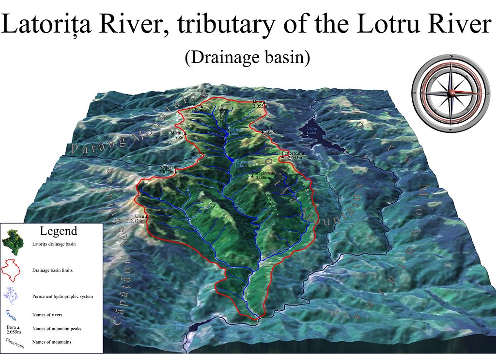
The basic unit of division of the landscape is the drainage basin. A drainage basin, also known as a catchment or watershed, is the area of land that captures precipitation and contributes runoff to a stream or stream segment (Figure). Drainage divides are local topographic high points that separate one drainage basin from another [5]. If water falls on one side of the divide, that water goes to one stream, and if it falls on the other side of the divide, then the water goes to a different stream. Each stream has its own drainage basin. Further, a drainage basin for each tributary can also be designated. In areas with flatter topography, drainage divides are not as easily identified but they still exist [6].
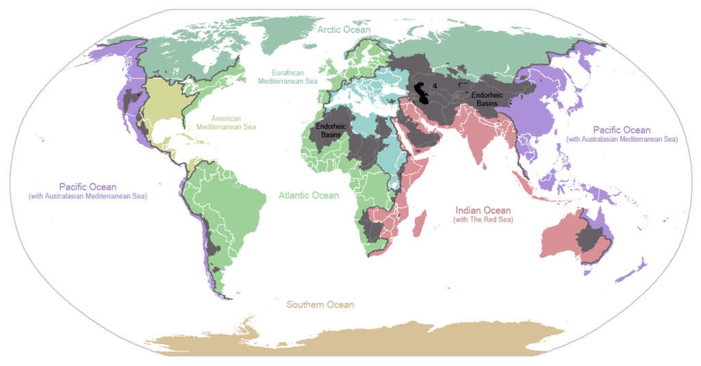
Streams only flow downhill and smaller tributary streams combine downhill to make the larger trunk of the stream. Where a stream begins is called the headwaters and where it finally reaches its end is called the mouth. Most streams have the mouth of the stream at the ocean. However, a rare number of streams do not flow to the ocean, but rather end in a closed basin (or endorheic basin) where the water evaporates from a stream or lake before it can reach the ocean. Most streams in the Great Basin are in closed basins. For example, Little Cottonwood Creek and the Jordan River flow into the Great Salt Lake where the water evaporates.
In humid climates, many streams are perennial and in arid climates like Utah, many streams are ephemeral. Perennial streams flow all year round. They occur in humid or temperate climates where there are sufficient rainfall and low evaporation rates. Water levels rise and fall with the seasons, depending on the discharge. Ephemeral streams flow only during rain events or the wet season. These are often dry washes or arroyos for much of the year. They are above the water table and occur in dry climates with low amounts of rainfall and high evaporation rates. They flow mostly during flash floods.
Special Topic: Watershed Protection Areas
Along Utah’s Wasatch Front, there are several watersheds that are designated as “Watershed Protection Areas” that limit the type of use allowed in those drainages. Dogs and swimming are limited in those watersheds because they could contribute harmful bacteria and substances to the drinking supply of Salt Lake City and surrounding municipalities.
Water in an area is very much like currency in a personal budget. There is income in the form of precipitation, stream inflow, and groundwater inflow, and there are expenses, in the form of groundwater withdrawal, evaporation, and stream and groundwater outflow. If the expenses outweigh the income, then the water budget is not balanced, and, if available, water will be removed from storage. Reservoirs, snow and ice, soil moisture, and aquifers can all act as storage in a water budget.
Water Budgets
Scientists can make groundwater budgets within any designated boundary, but they are generally made for watershed (basin) boundaries because groundwater and surface water are easier to account for within these boundaries. However, water budgets can be created for state, county, or aquifer extent boundaries as well. The groundwater budget is an essential component of the hydrologic model, where measured data are used with a conceptual workflow of the model to better understand the water system.
Like budgets for families and organizations, there is income from precipitation and expense from discharge and evaporation, with the ultimate expense for freshwater by returning to the salty ocean. For dry regions, the water budget is critical for sustaining human activities and understanding and managing it is an ongoing political challenge.