
19.6: Review and Additional Resources
- Page ID
- 17221

Review
Review and assess your learning. Start with the "Important Terms and Concepts" to ensure you know the terminology related to the topic of the chapter and concepts discussed. Move on to the "Review Questions" to answer critical thinking questions about concepts and processes discussed in the chapter. Finally, test your overall understanding by taking the "Self-assessment quiz".
-
- glaciation
- great ice sheets waxed and waned over the surface
-
- glacier
- a natural accumulation of land ice showing movement at some time
-
- firn
- granular form; transistion stage between snow and ice
-
- zone of accumulation
- the portion of the glacier over which accumulation exceeds ablation
-
- Zone of ablation
- where loss of ice mass is greater than accumulation
-
- equilibrium line
- boundary between zone of accumulation and zone of ablation
-
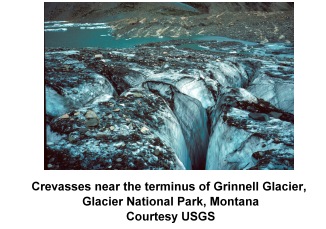
- crevasse
- a deep crack, crevice, or fissure found in a glacier
-
- internal deformation
- Under the weight of accumulating ice,the ice is deformed and begins to move by pseudo-plastic flow
-
- basal slip
- Glaciers slip over the surface lubricated by meltwater at their base
-
- crushing
- glaciers detach material from the surface by crushing the underlying bedrock
-
- quarry
- aka plucking; freezing around and into fractures, then lifting it from the surface
-
- striations
- fine scratches left in bedrock by abrasion
-
- grooves
- ground into the bedrock in the direction of ice movement
-
- chatter marks
- crescent-shaped marks left by chipping of bedrock
-
- polished bedrock
- caused by the constant abrasion of exposed rock
-
- glacial drift
- sediment transported and deposited by a glacier
-
- till
- deposited directly by a glacier
-
- stratified drift
- sorted sediment deposited by glacier
-
- moraine
- a glacially formed accumulation of unconsolidated debris
-
- terminal moraine
- an end moraine that marks the furthest advance of the ice sheet
-
- interlobate moraine
- form between lobes of the ice sheet
-
- ground moraine
- till deposited beneath a steadily retreating glacier that was lodged beneath the glacier and generally found behind the terminal moraine
-
- recessional moraine
- deposited when the ice sheet pauses during retreat
-
- outwash plain
- forms ahead of the terminal moraine as melt water from the snout of a glacier deposits stratified drift.
-
- kettle
- its in the surface that may or may not be occupied by water. They form when an isolated block of ice is surrounded by till or stratified drift.
-
- kame
- steep mounds or conical hills built by the deposition of stratified drift in or around ice
-
- esker
- sinuous ridges of glacio-fluvial material that form in tunnels in an ice sheet
-
- drumlin
- stream-lined hills that appear separately or in "swarms".
-
- cirque
- a huge, amphitheater-like depression at the valley head
-
- tarn
- a small lake formed after a glacier melts away
-
- horn
- a pyramid-shaped peak
-
- glacial trough
- valley takes on the characteristic U-shaped
-
- hanging valley
- When tributary valleys are left hanging at a higher elevation above the main valley floor as a result of more intensive downward cutting by the main valley glacier
-
- arête
- a serrated ridge
-
- rock step
- composed of the more resistant rocks with small depression behind them where the weaker rock is exposed
-
- staircase lakes
- rock steps occupied with water
-
- lateral moraine
- Glacial till deposited along the valley sides
-
- medial moraine
- When lateral moraines merge upon entering a main glacial trough
Briefly describe the conditions under which glaciers form.
- Answer
-
Glaciation occurs where the winter-time accumulation of snow exceeds the summer loss. Through time, snow accumulates to a sufficient depth to metamorphose into ice. Conditions for glaciation usually occur at high latitudes or high altitudes where temperatures are cool enough to inhibit melting.
Under what conditions will a glacier advance or retreat?
- Answer
-
If the mass balance is positive the glacier will advance. If the mass balance is negative it will retreat.
Describe how a glacier moves across the surface.
- Answer
-
Glaciers move when the weight of ice causes the ice to deform and bulge outwards from the zone of accumulation and bby basal slip, the sliding of ice over the surface on a film of meltwater.
How do glaciers erode the surface?
- Answer
-
Crushing, plucking and abrasion.
Compare and contrast glacial till and stratified drift.
- Answer
-
Till is an unsorted mixture of material deposited by ice. Stratified drift is sorted material deposited by melt water.
How do striations, grooves, and chatter marks indicate the direction of glacier flow?
- Answer
-
Striations and grooves are oriented in the direction of flow, while chatter marks are perpendicular to flow.
Compare and contrast ground, terminal, and recessional moraines.
- Answer
-
A moraine is an accumulation of till producing irregular topography and often taking the form of a belt of low hills. A terminal moraine marks the furthest advance of a glacier. A recessional moraine forms when the glacier recedes and stagnates for a period of time. Ground moraine is an irregular deposit of till spread over the surface beneath the ice.
How do kettles and kames form?
- Answer
-
Kettles are depressions left by melting ice blocks surrounded by till or stratified drift. Kames are steep-sided hills built by the deposition of stratified drift laid down in or around ice.
How do drumlins show the direction of glacier flow?
- Answer
-
The "tail" of the drumlin points in the direction of movement.
What is an esker and how does it form?
- Answer
-
Eskers form by the deposition of glacial drift, composed mostly of glacio-fluvial gravel in a subglacial stream during ice stagnation.
Explain how cirques and tarns form.
- Answer
-
Cirques are bowl-shaped depressions scoured into the side of a mountain by an alpine glacier. Tarns are small depressions filled with water on the cirque floor.
How do hanging valleys form?
- Answer
-
A hanging valley is a tributary valley left hanging at a high elevation above the main valley glacier floor.
What are horns are arêtes and how do they form?
- Answer
-
A horn is a pyramidal peak formed by the headward erosion of cirque glaciers. Arêtes are serrated ridges formed by the erosion of an interfluve by valley glaciers.
How do glacial valleys differ from stream valleys?
- Answer
-
Stream valleys are V-shaped while glaciated valleys are U-shaped.
How do staircase lakes form?
- Answer
-
Staircase lakes form when mountain valley streams are blocked by and fill depressions behind rock steps or moraines.
What relationship do medial moraines have to lateral moraines?
- Answer
-
Medial moraines form by the merger of lateral moraines.
- Which of the following landforms are most commonly associated with continental glaciation?
- cirques
- lateral moraine
- drumlins
- horns
- Unsorted material laid down by glacial ice is called
- till
- stratified drift
- alluvium
- none of the above
- Stratified drift
- is sorted
- laid down by melt water
- accumulates in layers
- all the above
- Which of the following is a product of glacial deposition?
- Striations
- A cirque
- A horn
- A drumlin
- Which feature is found in the zone of accumulation?
- A cirque
- A terminal moraine
- An outwash plain
- None of the above
- Which of the following features are found on the side of an alpine glacier?
- A lateral moraine
- A terminal moraine
- A medial moraine
- None of the above
- Which of the following features form parallel to the ice front?
- Striation
- Grooves
- Drumlins
- Chatter marks
- What is the ridge-like feature shown below?
- A drumlin
- An esker
- A cirque
- A horn
- Ground moraine
- is typically found behind a terminal moraine
- has been deposited beneath the ice
- is composed of unsorted till
- all the above
- You are hiking in a region that has been created by a continental glacier and see a steep sided, conical shaped hill. You decide that it must be a
- kettle
- an esker
- a drumlin
- a kame
- Answer
-
- C
- A
- D
- D
- A
- A
- D
- B
- D
- D
Additional Resources
Use these resources to further explore the world of geography
Multimedia
 "USGS Public Lecture Series: Baked Alaska--What's Happening to the Glaciers in Alaska?" (September, 2009)
"Glaciers" (Annenberg/CPB) from the site: "Many of the world’s most beautiful landscapes were made by glaciers. This program shows how, explaining glacial formation, structure, movement, and methods of gouging and accumulating earth. The program provides images of glaciers and glacial landforms such as moraines, and discusses how study of glaciers may help us understand ice ages and the greenhouse effect." (30:00) Go to the Earth Revealed site and scroll to "Glaciers". One-time, free registration may be required to view film.
Activity
"What's Happening to Alaska's Glaciers? Their Dynamic Response to Changing Climate and Other Factors" Dr. Bruce Molina (USGS) Descriptive Flyer pdf.
 "Snowball Earth" National Geographic
Visualization
![]() Satellite Image Atlas of Glaciers of the World (USGS)
Satellite Image Atlas of Glaciers of the World (USGS)
Readings
![]() Glaciers on Mt. Rainier (USGS Open-File Report 92-474) Brief overview of Mt. Rainier's glaciers including, glacier flow, glaciers and climate, and history of glacier fluctuations.
Glaciers on Mt. Rainier (USGS Open-File Report 92-474) Brief overview of Mt. Rainier's glaciers including, glacier flow, glaciers and climate, and history of glacier fluctuations.