
19.3: Landforms of Continental Glaciation
- Page ID
- 17210

A receding continental glacier exposes a variety of depositional and erosional landforms shown in Figure \(\PageIndex{1}\). Refer to this diagram as you read about the various landforms created by continental glaciers.
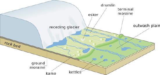
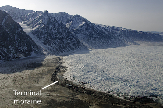
A moraine is a glacially formed accumulation of unconsolidated debris. Moraines often take the form of a belt of low hills composed of till. Those forming at the leading edge of the glacier end moraine ![]() can be found. A terminal moraine is an end moraine that marks the furthest advance of the ice sheet. A recessional moraine and end moraine deposited when the ice sheet pauses during retreat.
can be found. A terminal moraine is an end moraine that marks the furthest advance of the ice sheet. A recessional moraine and end moraine deposited when the ice sheet pauses during retreat.
Often, uplands will cause an ice sheet to separate into lobes. Interlobate moraines form between lobes of the ice sheet. Ground moraine is till deposited beneath a steadily retreating glacier that was lodged beneath the glacier and generally found behind the terminal moraine. Ground moraine. Wetland areas are often created in ground moraine which is a convenient way of identifying them from a topographic map.
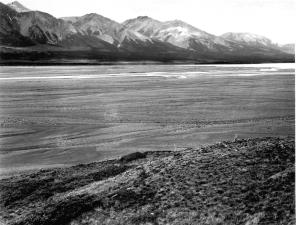
An outwash plain forms ahead of the terminal moraine as melt water from the snout of a glacier deposits stratified drift. The outwash plain is a relatively flat surface that may be pock marked with depressions called kettles. If numerous kettles are present the surface is called a pitted outwash plain.
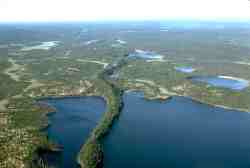
Eskers are sinuous ridges of glacio-fluvial material that form in tunnels in an ice sheet . The sides of the tunnel act as part of the channel for a melt water stream. As the glacier recedes, the support for the stream is removed and the stream deposits its load into a long ridge-like form. Eskers are good sources for sand and gravel, and many of them have been destroyed by mining for these materials.
Drumlins are stream-lined hills that appear separately or in "swarms". Their formation is not well known but form by the deposition of till. As the ice rides over the till it is smoothed into an inverted spoon-shaped feature. The steep side faces the direction the ice sheet came from while the more gentle slope of the tail points toward the direction of ice flow.
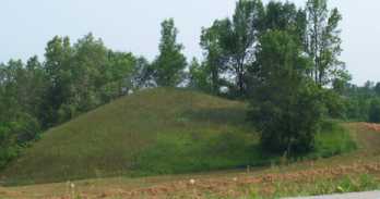
Kames are steep mounds or conical hills built by the deposition of stratified drift in or around ice. Some kames form in holes in the ice where sediment accumulates. A mound of glacial drift is left behind once the ice melts.
Kettles are pits in the surface that may or may not be occupied by water. They form when an isolated block of ice is surrounded by till or stratified drift. After a period of time the ice block melts away leaving behind a hole in the surface. Kettles are often found on outwash plains or embedded in moraines (hence the name for Kettle Moraine State Forest in Wisconsin).
Video: "Moulin, Kame, and Esker Formation" (Courtesy of UBC Virtual Soil Learning Resources)