15.3.3: Tsunamis
- Page ID
- 16492

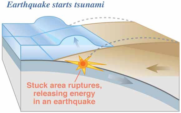
A tsunami is a fast moving, long wavelength water wave generated by a sudden displacement of water by undersea landslides, earthquakes, or volcanic activity. They are commonly called "tidal waves", but are by no means created by the tides. The sudden slippage of the ocean floor near the source of an earthquake can send a train of seismic waves across the ocean. When an overriding plate along a subduction zone suddenly breaks free it moves upward raising the sea floor and the water above. The waves move outward in ever-expanding circles, nearly imperceptible in deep ocean water. As they approach land, water recedes from the shore. This dramatic action often entices the curious to investigate. But very shortly a water wave rises rapidly from the ocean surface, crashing onto shore and rushing landward.
On December 26th, 2004 subduction between the Indian and Eurasian (more specifically the Burma) plates off the coast off the coast of Indonesia resulted in a magnitude 9 earthquake and large tsunami that devastated South Asia. [Watch  "Violent Earth" from National Geographic.] The earthquake was a result of stresses being released when the Indian plate slid beneath the Burma plate. The resulting vertical movement of the ocean floor displaced hundreds of cubic meters of water and large waves propagated outward from the focus of the quake. The massive tsunami
  devastated coastal regions of South Asia as it crashed ashore.
Video: "Killer Tsunamis" from National Geographic
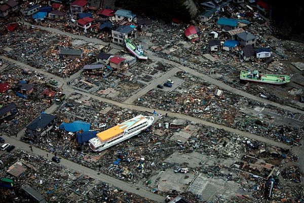
One of the largest earthquakes to occur in recent memory occurred March 11, 2011 off the coast of Japan. The huge tsunami it created devasted the northeast coast of Japan, destroying towns and infrastructure. Learn more about this magnitude 9 earthquake and its aftermath by "Digging Deeper: The Great East Japan Earthquake of 2011", or skip and continue reading.
Digging Deeper: The Great East Japan Earthquake of 2011
On March 11, 2011 the Island of Japan was rocked by a violent earthquake. The magnitude 9 Tōhoku earthquake, officially named the Great East Japan Earthquake, originated 129 km (80 miles) offshore east of Sendai, Honshu, Japan, at a depth of 30 km. It was the fourth largest earthquake in the world since 1900. Honshu lies near the junction of the North American, Eurasian, Pacific, and Phillippine Sea plates. The massive earthquake radiated from plates slipping along the subduction zone, actually moving the entire country. Areas near Ishinomaki moved southeast by 5.3 meters (17 feet), while parts of Tokyo moved 9 inches.

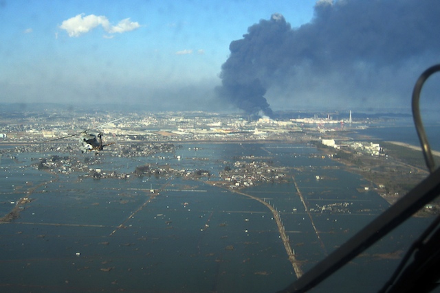
As the North American plate slid upward over the Pacific plate, a 16 foot bulge of water rose and swept across the Pacific at an estimated 500 mph. As the water approached land the wave increased to incredible heights. A huge tsunami washed across the northern coast of Japan within moments. Sendai airport was inundated by a wall of water 12 m(39 ft) high. An estimated tsunami height of 37.9 m (124 ft) swept across the slope of a mountain 200 m (656 ft) from the coast. Flooded fields several kilometers inland remained so after more than a week due in part to coastal subsidence. Land subsidence at Oshika Peninsula Miyagi was as much as 1.2 m (3.93 ft). Those coast locations suffering from subsidence are now more susceptible to flooding during high tides.
Video: Tōhoku earthquake tsunami propagation (Courtesy NOAA)
The effects of the tsunami were far more deadly than the earthquake itself. Nearly 15,000 people were killed and 10,000 missing. Hundreds of thousands were left homeless as whole towns were devastated. The earthquake and subsequent tsunami severely damaged the Fukushima nuclear reactor station in the towns of Okuma and Futaba, leaking radioactivity into the air and water. Large evacuations of the surrounding area and contamination of food and water supplies resulted from the leakage.
Damage from the tsunami was not confined to Japan. Tens of millions of dollars in damage to public infrastructure and private property occurred in Hawaii. Along the west coast of North America docks and harbor facilities were damaged as a tsunami surge of up to 2.4 m (8 ft) struck portions of California and Oregon. An California man attempting to photograph the rising water was swept out to sea and died.